| Ryker-Grayford silt loams, karst, rolling, eroded | RzvC2 | 2618 | 185178 | 66ph | in019 | 2001 | 1:12000 |
Ryker-Grayford silt loams, 6 to 12 percent slopes, eroded | RztC2 | 2251 | 210676 | 7270 | in019 | 2001 | 1:12000 |
Ryker-Grayford silt loams, 6 to 12 percent slopes, severely eroded | RztC3 | 1452 | 201113 | 6r8j | in019 | 2001 | 1:12000 |
Ryker-Grayford silt loams, karst, rolling, severely eroded | RzvC3 | 1289 | 185179 | 66pj | in019 | 2001 | 1:12000 |
Grayford silt loam, karst, hilly, severely eroded | GykD3 | 625 | 198262 | 6n9k | in019 | 2001 | 1:12000 |
Grayford silt loam, karst, hilly, eroded | GykD2 | 581 | 201118 | 6r8p | in019 | 2001 | 1:12000 |
Grayford silt loam, 12 to 25 percent slopes, eroded | GyaD2 | 436 | 210678 | 7272 | in019 | 2001 | 1:12000 |
Grayford silt loam, 12 to 25 percent slopes, severely eroded | GyaD3 | 148 | 210679 | 7273 | in019 | 2001 | 1:12000 |
Grayford silt loam, 12 to 25 percent slopes, gullied | GyaD5 | 23 | 201122 | 6r8t | in019 | 2001 | 1:12000 |
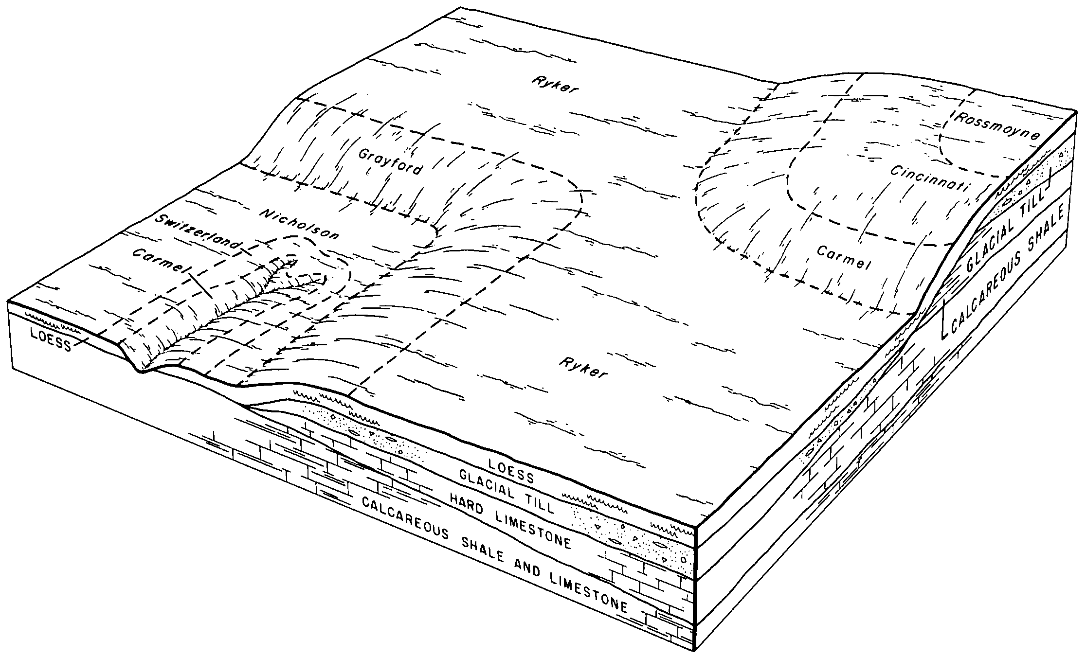
Grayford-Ryker silt loams, 4 to 10 percent slopes, eroded | GrC2 | 1318 | 162385 | 5fz7 | in031 | 1980 | 1:15840 |
Grayford silt loam, 10 to 20 percent slopes | GfD | 765 | 162384 | 5fz6 | in031 | 1980 | 1:15840 |
Grayford silt loam, 12 to 18 percent slopes, eroded | GrD2 | 2931 | 964652 | 11cst | in077 | 1982 | 1:15840 |
Grayford silt loam, 6 to 12 percent slopes, eroded | GrC2 | 1290 | 964650 | 11csr | in077 | 1982 | 1:15840 |
Grayford silt loam, 12 to 18 percent slopes, severely eroded | GrD3 | 1081 | 964653 | 11csv | in077 | 1982 | 1:15840 |
Grayford silt loam, 6 to 12 percent slopes, severely eroded | GrC3 | 320 | 964651 | 11css | in077 | 1982 | 1:15840 |
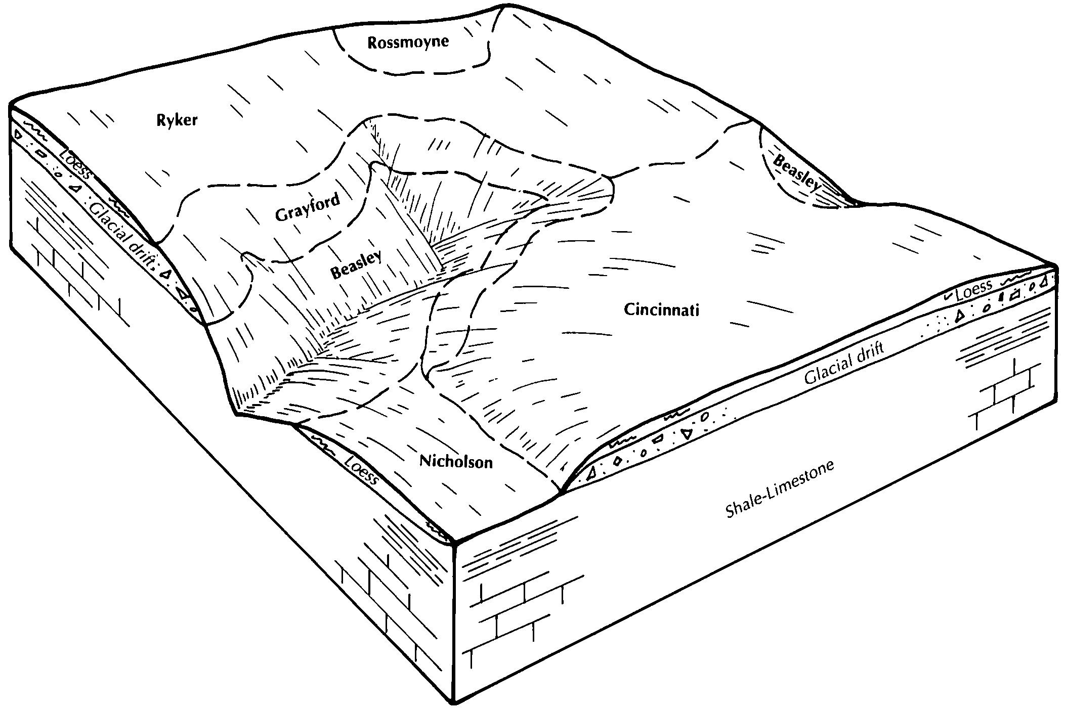
Hickory-Grayford silt loams, 12 to 25 percent slopes, eroded | HizE2 | 3119 | 1716797 | 1vmgk | in079 | 2010 | 1:12000 |
Ryker-Grayford-Muscatatuck complex, karst, rolling, severely eroded | RzhC3 | 1481 | 848708 | xh4p | in079 | 2010 | 1:12000 |
Caneyville and Grayford silt loams, 12 to 25 percent slopes, eroded | CcgD2 | 1418 | 1612735 | 1r45q | in079 | 2010 | 1:12000 |
Hickory-Grayford silt loams, 12 to 25 percent slopes, severely eroded | HizE3 | 1090 | 1716799 | 1vmgm | in079 | 2010 | 1:12000 |
Bonnell-Grayford silt loams, karst, hilly, eroded | BnxE2 | 610 | 1861470 | 20h0f | in079 | 2010 | 1:12000 |
Caneyville and Grayford silt loams, 12 to 25 percent slopes, severely eroded | CcgD3 | 594 | 709113 | rswm | in079 | 2010 | 1:12000 |
Bonnell-Grayford silt loams, karst, hilly, severely eroded | BnxE3 | 51 | 2427927 | 2mhg7 | in079 | 2010 | 1:12000 |
Grayford silt loam, 6 to 12 percent slopes | GrC | 1189 | 163217 | 5gv2 | in109 | 1979 | 1:15840 |
Grayford silt loam, 12 to 18 percent slopes, eroded | GrD2 | 244 | 163218 | 5gv3 | in109 | 1979 | 1:15840 |
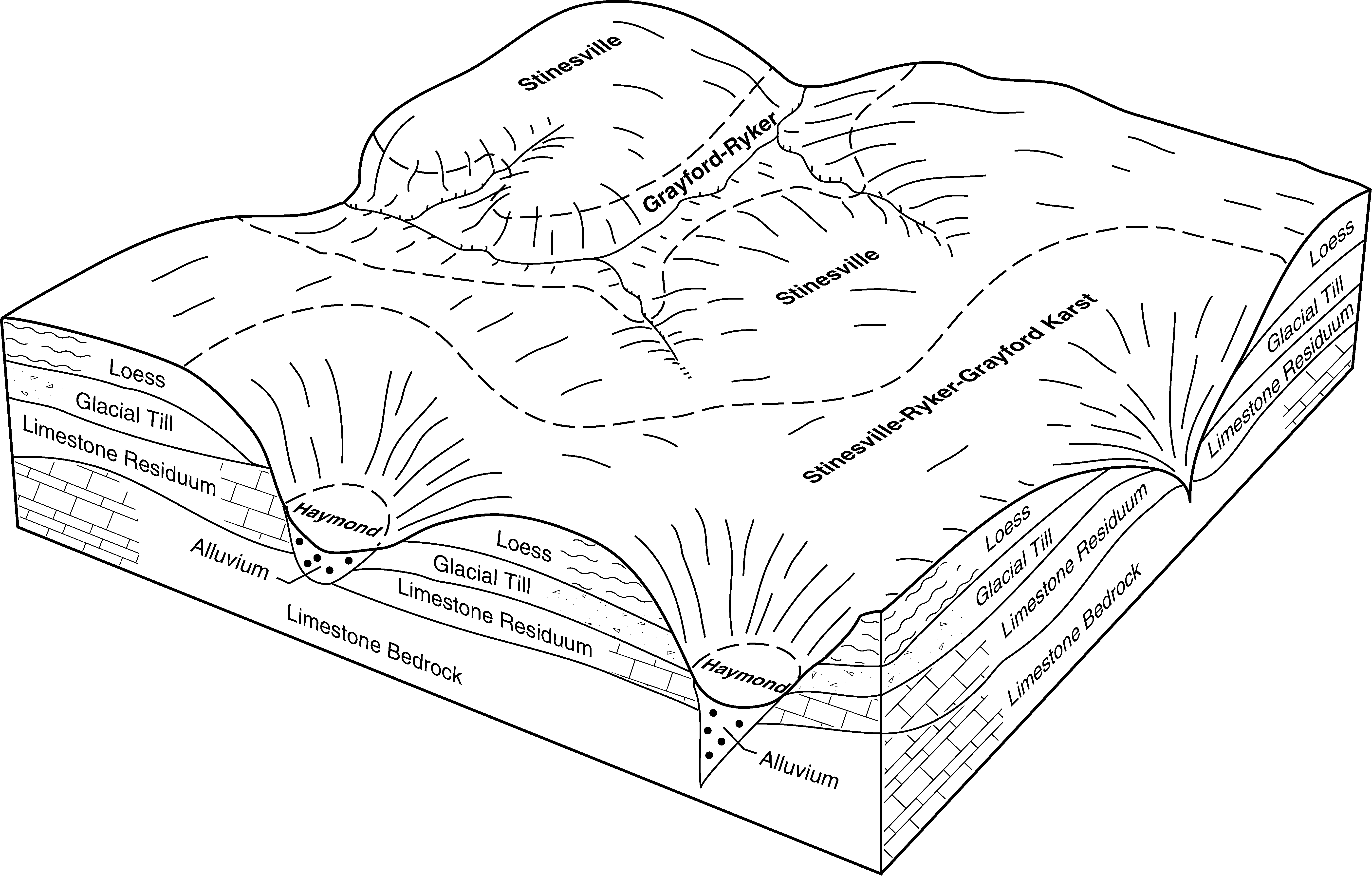
Stinesville-Ryker-Grayford silt loams, karst, hilly, eroded | StgD2 | 2614 | 166309 | 5l1t | in119 | 1997 | 1:12000 |
Grayford silt loam, 18 to 25 percent slopes, eroded | GmcE2 | 1956 | 166007 | 5kr2 | in119 | 1997 | 1:12000 |
Grayford-Ryker silt loams, 12 to 18 percent slopes, eroded | GmhD2 | 1534 | 166008 | 5kr3 | in119 | 1997 | 1:12000 |
Grayford silt loam, 12 to 18 percent slopes, severely eroded | GmcD3 | 1006 | 166006 | 5kr1 | in119 | 1997 | 1:12000 |
Stinesville-Ryker-Grayford silt loams, karst, rolling, eroded | StgC2 | 800 | 166308 | 5l1s | in119 | 1997 | 1:12000 |
Grayford silt loam, 6 to 12 percent slopes, eroded | GrC2 | 1137 | 159833 | 5c9x | in133 | 1979 | 1:15840 |
Grayford silt loam, 12 to 18 percent slopes, eroded | GrD2 | 990 | 159834 | 5c9y | in133 | 1979 | 1:15840 |
Grayford silt loam, 18 to 25 percent slopes, eroded | GrE2 | 529 | 159835 | 5c9z | in133 | 1979 | 1:15840 |
Grayford silt loam, 18 to 35 percent slopes | GrE | 3035 | 1479635 | 1lnp5 | in137 | 1982 | 1:15840 |
Grayford silty clay loam, 12 to 18 percent slopes, eroded | GrD2 | 2476 | 1479634 | 1lnp4 | in137 | 1982 | 1:15840 |
Grayford-Beasley complex, 12 to 20 percent slopes, eroded | GbD2 | 5204 | 551921 | lj9x | ky622 | 1989 | 1:20000 |
Boston-Grayford silt loams, 2 to 6 percent slopes, moderately eroded | BnB2 | 3631 | 1420369 | 1jp0c | oh071 | 1973 | 1:15840 |
Boston-Grayford silt loams, 2 to 6 percent slopes | BnB | 2220 | 1420368 | 1jp0b | oh071 | 1973 | 1:15840 |


