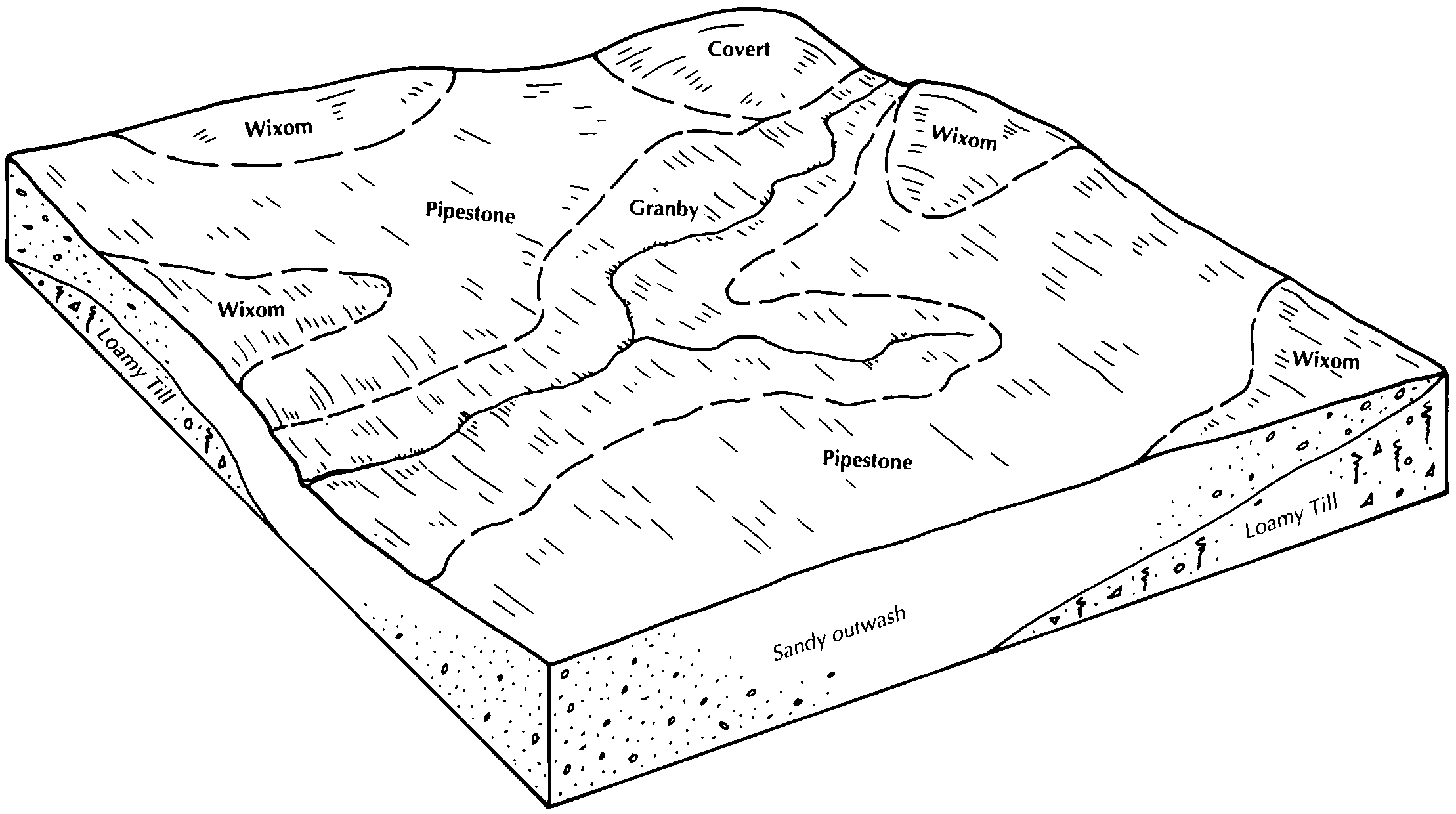
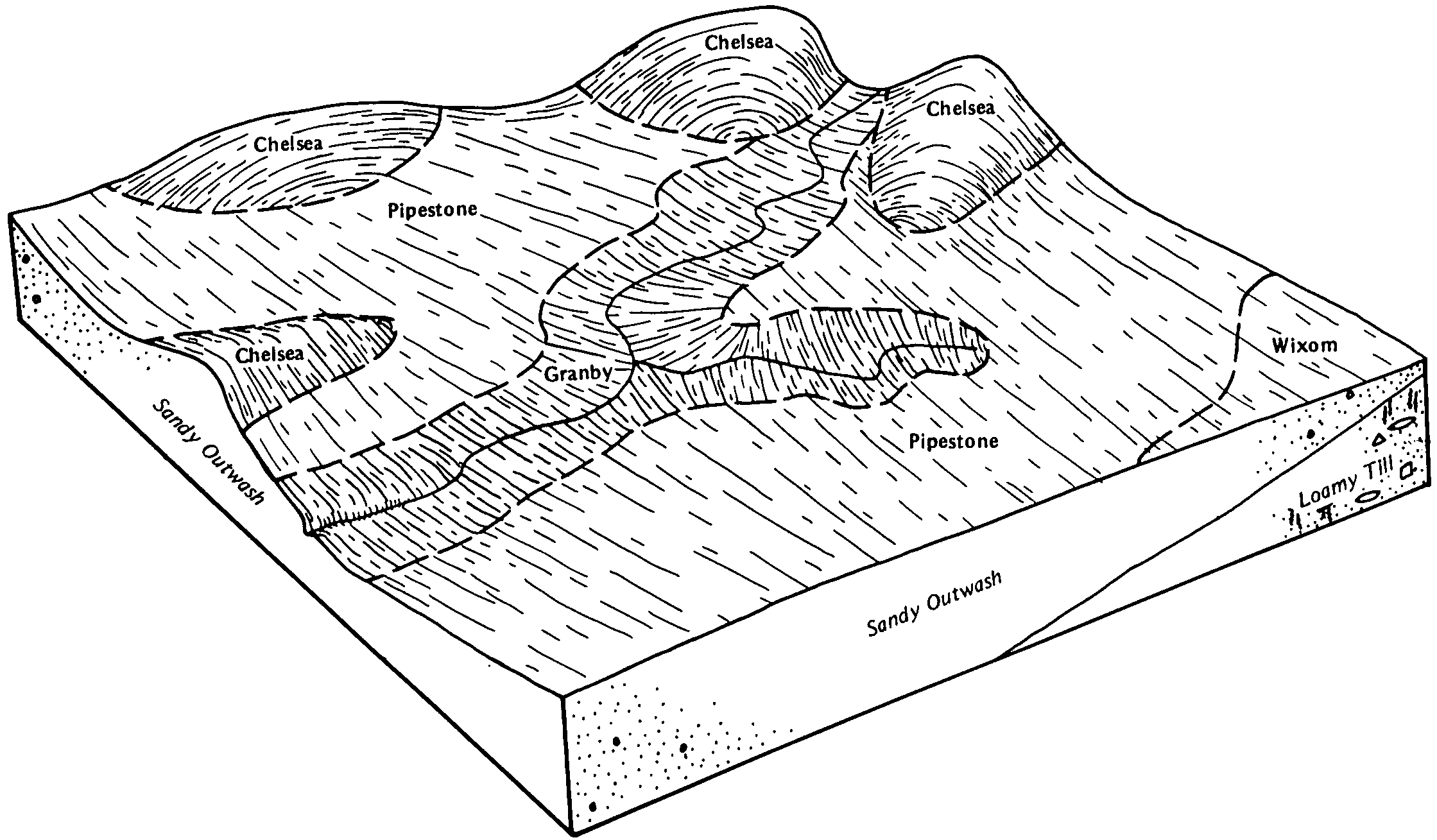
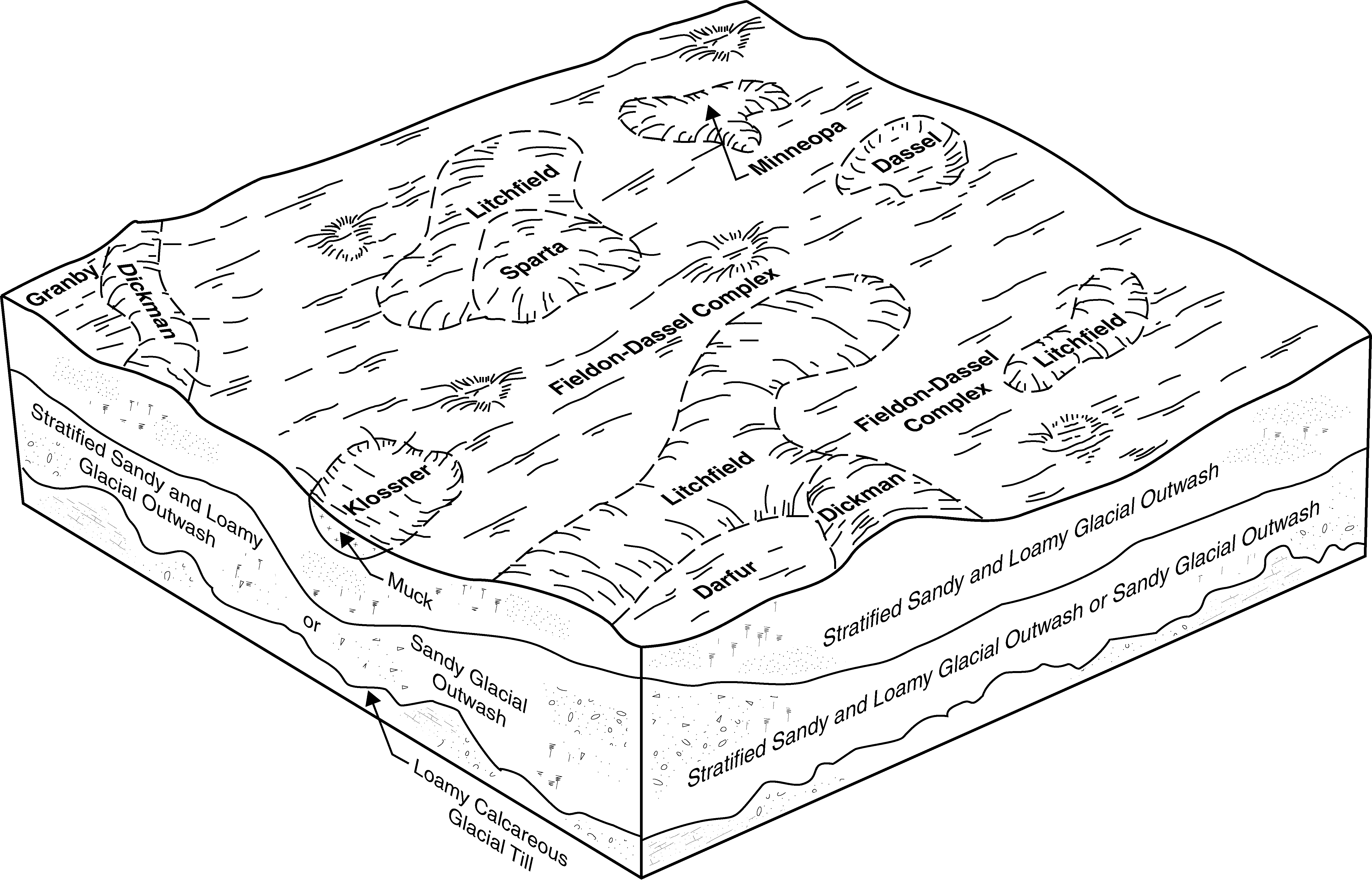
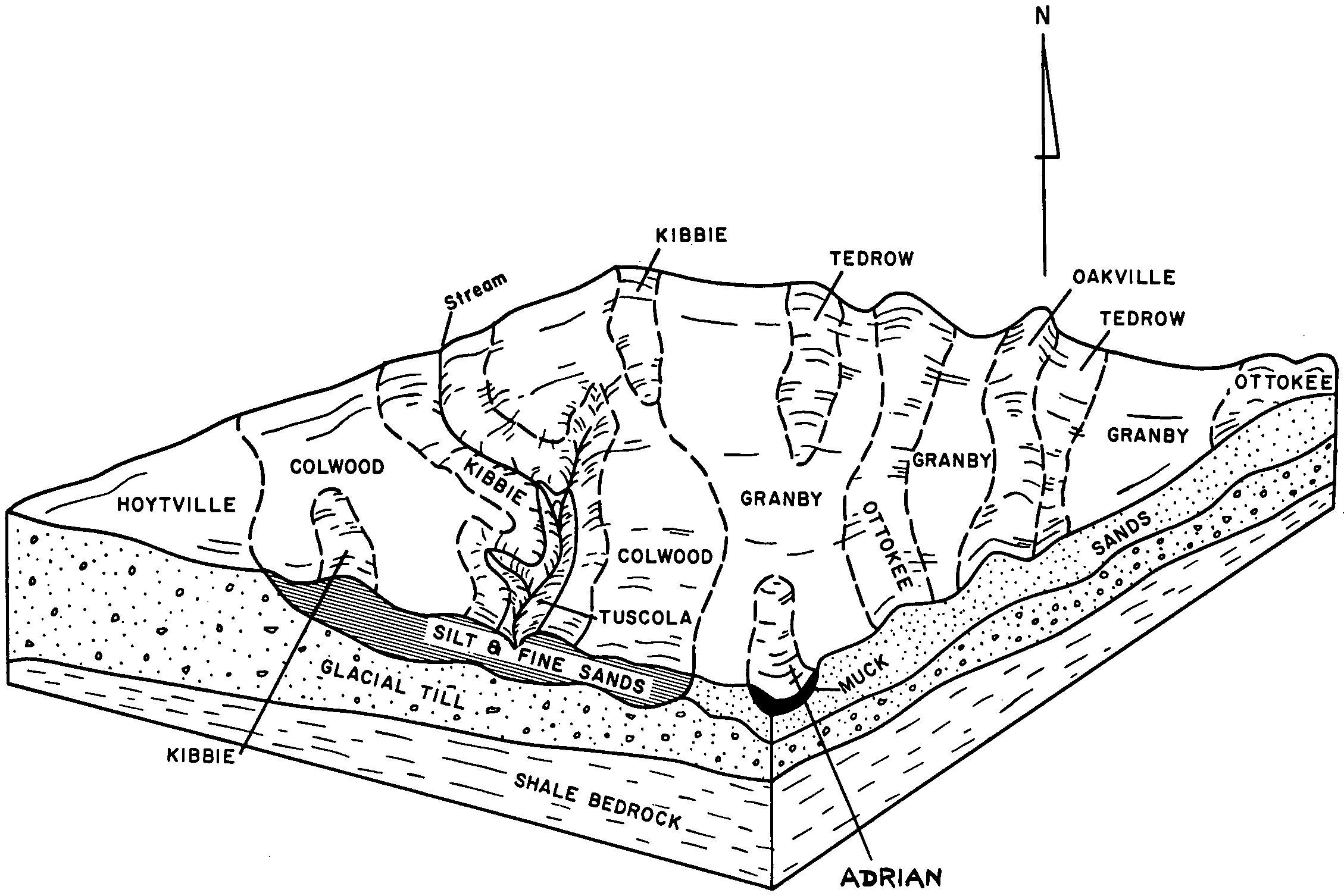
| Granby fine sandy loam, 0 to 2 percent slopes | 42 | 1124 | 404425 | 30qwm | ia045 | 1978 | 1:15840 |
Granby fine sandy loam, 0 to 2 percent slopes | 42 | 203 | 408159 | 30qwm | ia105 | 1988 | 1:15840 |
Granby fine sandy loam, 0 to 2 percent slopes | 513A | 1085 | 1384426 | 1hglx | il063 | 2005 | 1:12000 |
Granby fine sandy loam, 0 to 2 percent slopes | 513A | 6088 | 175588 | 2zdj5 | il075 | 1980 | 1:15840 |
Granby fine sandy loam, 0 to 2 percent slopes | 513A | 12790 | 263222 | 2zdj5 | il091 | 2003 | 1:12000 |
Granby fine sandy loam, 0 to 2 percent slopes | 513A | 578 | 789462 | 2zdj5 | il097 | 2003 | 1:12000 |
Granby fine sandy loam, 0 to 2 percent slopes | 513A | 6571 | 215037 | 2zdj5 | il197 | 2002 | 1:12000 |
Granby loamy sand, 0 to 2 percent slopes | GndA | 262 | 165372 | 2w5mv | in039 | 1997 | 1:12000 |
Granby loamy fine sand, 0 to 2 percent slopes | Gr | 1078 | 272600 | 2w5mx | in087 | 1978 | 1:20000 |
Granby loamy fine sand, 0 to 2 percent slopes | Gt | 31604 | 163588 | 2w5mx | in111 | 1990 | 1:15840 |
Zadog-Granby complex | Zg | 19295 | 163822 | 5hgl | in111 | 1990 | 1:15840 |
Granby mucky loamy fine sand | Gn | 1235 | 163586 | 5h6z | in111 | 1990 | 1:15840 |
Granby loamy fine sand, 0 to 2 percent slopes | GrfA | 2304 | 184937 | 2w5mx | in131 | 2001 | 1:12000 |
Granby-Gilford complex, 0 to 1 percent slopes | GsaA | 1452 | 185004 | 66hw | in131 | 2001 | 1:12000 |
Granby variant loamy sand | Gs | 1437 | 160199 | 5cpq | in151 | 1979 | 1:20000 |
Granby loamy sand | Gw | 285 | 161778 | 5fbn | in183 | 1985 | 1:15840 |
Granby loamy sand, lake plain, 0 to 2 percent slopes | 39 | 13229 | 212460 | 2w5mw | mi005 | 1984 | 1:15840 |
Granby loamy sand, 0 to 2 percent slopes | 19 | 1945 | 186066 | 2w5mv | mi015 | 1988 | 1:15840 |
Granby loamy fine sand, lake plain, 0 to 2 percent slopes | 37 | 4665 | 186177 | 2w5my | mi021 | 1979 | 1:15840 |
Granby-Morocco complex, 0 to 3 percent slopes | 68A | 1033 | 186199 | 67rf | mi021 | 1979 | 1:15840 |
Granby loamy sand, 0 to 2 percent slopes | 62 | 1347 | 188719 | 2w5mv | mi025 | 1993 | 1:15840 |
Granby loamy sand, 0 to 2 percent slopes | Gr | 831 | 186373 | 2w5mv | mi037 | 1974 | 1:15840 |
Granby loamy sand | Gm | 2957 | 186853 | 68fj | mi049 | 1967 | 1:20000 |
Granby fine sand | Go | 964 | 2399524 | 2ljx0 | mi049 | 1967 | 1:20000 |
Granby sand, loamy substratum | Gl | 168 | 2399549 | 2ljxt | mi049 | 1967 | 1:20000 |
Granby loamy fine sand | Gn | 33 | 2423844 | 2mc6j | mi049 | 1967 | 1:20000 |
Granby sand, loamy substratum | Gs | 1094 | 2673585 | 688n | mi057 | 1975 | 1:12000 |
Granby fine sand | Gr | 162 | 2673584 | 687p | mi057 | 1975 | 1:12000 |
Granby loamy sand | 45 | 1221 | 186794 | 68cm | mi063 | 1978 | 1:20000 |
Granby loamy fine sand, 0 to 2 percent slopes | Gr | 1569 | 186729 | 2w5mx | mi065 | 1977 | 1:15840 |
Granby loamy sand, 0 to 2 percent slopes | Go | 665 | 187974 | 2w5mv | mi067 | 1965 | 1:15840 |
Granby loamy sand, lake plain, 0 to 2 percent slopes | Gy | 901 | 187065 | 2w5mw | mi077 | 1978 | 1:15840 |
Granby loamy fine sand, 0 to 2 percent slopes | 43 | 4245 | 187147 | 2w5mx | mi081 | 1984 | 1:15840 |
Granby loamy sand | Gm | 2954 | 192026 | 6ftd | mi087 | 1966 | 1:15840 |
Granby loam | Gn | 297 | 192027 | 6ftf | mi087 | 1966 | 1:15840 |
Granby loamy fine sand | Gk | 10 | 2508401 | 6933 | mi087 | 1966 | 1:15840 |
Granby sandy loam, 0 to 3 percent slopes | GeA | 560 | 188485 | 6b45 | mi091 | 1957 | 1:20000 |
Granby loamy sand, 0 to 3 percent slopes | GdA | 276 | 188484 | 6b44 | mi091 | 1957 | 1:20000 |
Granby loamy fine sand | Gm | 5099 | 187646 | 6983 | mi099 | 1967 | 1:20000 |
Granby-Urban land complex, dense substratum, 0 to 2 percent slopes | GrbuaA | 419 | 3015242 | 2tx71 | mi099 | 1967 | 1:20000 |
Granby fine sand | Gn | 19 | 2673545 | 687p | mi111 | 1976 | 1:15840 |
Granby loamy fine sand | 18 | 15624 | 187228 | 68tm | mi115 | 1980 | 1:15840 |
Granby loamy sand, lake plain, 0 to 2 percent slopes | Ga | 5557 | 187345 | 2w5mw | mi121 | 1966 | 1:15840 |
Granby mucky sand | 20 | 2815 | 186452 | 680l | mi123 | 1990 | 1:15840 |
Granby mucky sand, gravelly substratum | 27 | 2135 | 186459 | 680t | mi123 | 1990 | 1:15840 |
Granby loamy sand | 39 | 2638 | 188842 | 6bhp | mi125 | 1980 | 1:15840 |
Granby-Urban land complex, dense substratum, 0 to 2 percent slopes | GrbuaA | 63 | 3015268 | 2tx71 | mi125 | 1980 | 1:15840 |
Granby loamy sand, lake plain, 0 to 2 percent slopes | 52 | 9382 | 189055 | 2w5mw | mi127 | 1992 | 1:15840 |
Granby mucky loamy sand, gravelly substratum | 41 | 1623 | 189030 | 6bpr | mi127 | 1992 | 1:15840 |
Granby loamy sand, lake plain, 0 to 2 percent slopes | Gm | 37128 | 192667 | 2w5mw | mi139 | 1967 | 1:15840 |
Granby fine sandy loam, lake plain, 0 to 2 percent slopes | Gn | 7105 | 192668 | 2zdj6 | mi139 | 1967 | 1:15840 |
Granby fine sand | 33 | 18272 | 186672 | 687p | mi145 | 1991 | 1:15840 |
Granby sand, loamy substratum | 82 | 6995 | 186702 | 688n | mi145 | 1991 | 1:15840 |
Granby loamy fine sand | 151 | 1332 | 2673616 | 6933 | mi145 | 1991 | 1:15840 |
Granby loamy fine sand | Gm | 14 | 2508371 | 6983 | mi147 | 1969 | 1:20000 |
Granby loamy fine sand | Gn | 64 | 2508275 | 6933 | mi151 | 1955 | 1:15840 |
Granby loamy sand, 0 to 2 percent slopes | Go | 960 | 187801 | 2w5mv | mi155 | 1967 | 1:12000 |
Granby loamy fine sand | 33 | 17816 | 187491 | 6933 | mi157 | 1984 | 1:15840 |
Granby loamy fine sand | Gs | 1587 | 2508709 | 68tm | mi161 | 1974 | 1:20000 |
Granby fine sand | Gr | 698 | 191631 | 6fdn | mi161 | 1974 | 1:20000 |
Granby loamy fine sand | Gr | 12176 | 3015043 | 6bk8 | mi163 | 1974 | 1:12000 |
Granby-Urban land complex, dense substratum, 0 to 2 percent slopes | GrbuaA | 470 | 3015130 | 2tx71 | mi163 | 1974 | 1:12000 |
Granby loamy sand | Gy | 82 | 3015230 | 6bhp | mi163 | 1974 | 1:12000 |
Granby fine sandy loam | 178 | 1425 | 396145 | f96w | mn013 | 1975 | 1:12000 |
Webster-Darfur-Granby complex | 968 | 626 | 396233 | f99q | mn013 | 1975 | 1:12000 |
Granby fine sandy loam, 0 to 1 percent slopes | 178 | 1889 | 436296 | gn02 | mn093 | 1996 | 1:20000 |
Granby loamy fine sand, very wet, 0 to 1 percent slopes | 1099 | 466 | 436179 | gmw9 | mn093 | 1996 | 1:20000 |
Granby loamy sand | 178 | 247 | 428922 | gdb6 | mn165 | 1987 | 1:20000 |
Granby loamy fine sand, very wet, 0 to 1 percent slopes | 1099 | 160 | 435027 | glp4 | mn171 | 1998 | 1:12000 |
Granby loamy fine sand | Gr | 1884 | 288731 | 9pfx | ny001 | 1985 | 1:15840 |
Granby mucky loamy fine sand | Gr | 973 | 291827 | 9sns | ny045 | 1981 | 1:15840 |
Granby loamy sand, 0 to 2 percent slopes | SfA | 751 | 2677793 | bmnw | ny049 | 2018 | 1:24000 |
Granby fine sandy loam, 0 to 2 percent slopes | GrA | 567 | 2677692 | bmkp | ny049 | 2018 | 1:24000 |
Granby loamy fine sand | Gr | 277 | 292818 | 9tpr | ny057 | 1973 | 1:24000 |
Naumburg-Granby complex, gently sloping | NGB | 14894 | 294139 | 9w2c | ny075 | 1973 | 1:15840 |
Granby loamy fine sand | Gr | 701 | 294115 | 9w1l | ny075 | 1973 | 1:15840 |
Granby loamy fine sand | Gr | 430 | 309575 | bd49 | ny093 | 1973 | 1:15840 |
Granby loamy sand, clayey substratum | Gx | 3 | 1539732 | 1np6s | oh039 | 1981 | 1:15840 |
Granby loamy fine sand | Gr | 11781 | 169088 | 5nyg | oh051 | 1981 | 1:15840 |
Granby loamy fine sand | Gr | 6281 | 168993 | 5nvd | oh069 | 1968 | 1:15840 |
Granby sandy loam | Gr | 1365 | 286817 | 9mg5 | oh085 | 1976 | 1:15840 |
Granby loamy fine sand | Gr | 19748 | 169845 | 5pqw | oh095 | 1978 | 1:15840 |
Granby-Urban land complex | Gs | 882 | 169846 | 5pqx | oh095 | 1978 | 1:15840 |
Granby loamy sand, clayey substratum | Gr | 256 | 244567 | 86h8 | oh125 | 1993 | 1:12000 |
Granby loamy sand | Gx | 1007 | 169564 | 5pft | oh143 | 1983 | 1:15840 |
Granby loamy fine sand, till substratum, 0 to 1 percent slopes | GpA | 1831 | 168313 | 5n4g | oh173 | 2000 | 1:12000 |
Granby fine sandy loam | 7513A | 772 | 3268474 | g60h | wi015 | 2023 | 1:15840 |
Granby loamy sand | 7515A | 12037 | 423278 | g6g4 | wi021 | 1972 | 1:15840 |
Granby loamy sand | 7515A | 2515 | 753511 | t92t | wi025 | 1972 | 1:15840 |
Granby variant fine sandy loam | 7513A | 1565 | 423575 | g6rq | wi027 | 1976 | 1:15840 |
Granby loamy fine sand | 7514A | 10320 | 423680 | g6w3 | wi047 | 1974 | 1:20000 |
Granby loamy fine sand, loamy subsoil variant, 0 to 3 percent slopes | 7814A | 4351 | 423681 | g6w4 | wi047 | 1974 | 1:20000 |
Granby loamy fine sand, clayey subsoil variant, 0 to 3 percent slopes | 7914A | 2347 | 423682 | g6w5 | wi047 | 1974 | 1:20000 |
Granby fine sandy loam, brown subsoil variant, 0 to 3 percent slopes | 7613A | 1225 | 3268648 | g77q | wi059 | 2023 | 1:15840 |
Granby fine sandy loam | 7513A | 515 | 3268646 | g77n | wi059 | 2023 | 1:15840 |
Granby fine sandy loam, loamy substratum | 7813A | 15 | 3268647 | g77p | wi059 | 2023 | 1:15840 |
Granby fine sandy loam | 7513A | 5798 | 3268534 | g60h | wi071 | 2023 | 1:15840 |
Oakville-Granby complex, 0 to 4 percent slopes | 7641B | 1163 | 3268602 | 30752 | wi071 | 2023 | 1:15840 |
Granby fine sandy loam | 7513A | 9205 | 426081 | g9ck | wi077 | 1969 | 1:20000 |
Granby fine sandy loam, loamy substratum | 7813A | 6398 | 426082 | g9cl | wi077 | 1969 | 1:20000 |
Granby loamy fine sand | 7514A | 2762 | 426080 | g9cj | wi077 | 1969 | 1:20000 |
Granby loamy sand, loamy substratum | 7815A | 317 | 425966 | g97v | wi089 | 1967 | 1:15840 |
Granby fine sandy loam, loamy substratum | 7813A | 265 | 3268779 | g77p | wi101 | 2023 | 1:15840 |
Granby fine sandy loam | 7513A | 209 | 3268778 | g77n | wi101 | 2023 | 1:15840 |
Granby variant, loamy sand | 7525A | 1666 | 423166 | g6bj | wi111 | 1977 | 1:15840 |
Granby loamy sand | 7515A | 1559 | 423165 | g6bh | wi111 | 1977 | 1:15840 |
Granby silt loam, gravelly variant | 7916A | 1197 | 423880 | g72k | wi117 | 1974 | 1:15840 |
Granby loamy fine sand | 7514A | 1050 | 423879 | g72j | wi117 | 1974 | 1:15840 |
Adrian-Granby-Oakville complex | 7039A | 663 | 423851 | g71m | wi117 | 1974 | 1:15840 |
Granby fine sandy loam, 0 to 3 percent slopes | 7513A | 275 | 425723 | g900 | wi131 | 1967 | 1:15840 |
Granby fine sandy loam | 7513A | 256 | 3403429 | g93t | wi133 | 2023 | 1:15840 |
