| Sogn-Gosport-Clanton complex, 9 to 18 percent slopes, moderately eroded | 413D2 | 1160 | 402683 | fj0s | ia007 | 1970 | 1:15840 |
Gosport-Clanton silt loams, 14 to 18 percent slopes, moderately eroded complex | 313E2 | 744 | 402676 | fj0k | ia007 | 1970 | 1:15840 |
Gosport-Clanton silt loams, 9 to 14 percent slopes, moderately eroded complex | 313D2 | 736 | 402675 | fj0j | ia007 | 1970 | 1:15840 |
Gosport-Clanton silt loams, 18 to 24 percent slopes, moderately eroded complex | 313F2 | 243 | 402677 | fj0l | ia007 | 1970 | 1:15840 |
Gosport silt loam, 18 to 30 percent slopes, moderately eroded | 313F2 | 1315 | 406377 | fmvy | ia077 | 1968 | 1:15840 |
Gosport silt loam, 9 to 18 percent slopes, moderately eroded | 313E2 | 310 | 406376 | fmvx | ia077 | 1968 | 1:15840 |
Clanton-Gosport silt loams, 18 to 25 percent slopes, moderately eroded | 322F2 | 2429 | 409174 | fqs5 | ia121 | 1968 | 1:15840 |
Clanton-Gosport silt loams, 25 to 40 percent slopes, moderately eroded | 322G2 | 1301 | 409175 | fqs6 | ia121 | 1968 | 1:15840 |
Clanton-Gosport silt loams, 14 to 18 percent slopes, moderately eroded | 322E2 | 499 | 409173 | fqs4 | ia121 | 1968 | 1:15840 |
Gosport silt loam, 18 to 25 percent slopes | 313F | 318 | 409201 | fqt1 | ia121 | 1968 | 1:15840 |
Clanton-Gosport silt loams, 9 to 14 percent slopes, moderately eroded | 322D2 | 220 | 409172 | fqs3 | ia121 | 1968 | 1:15840 |
Gosport silt loam, 14 to 18 percent slopes | 313E | 218 | 409200 | fqt0 | ia121 | 1968 | 1:15840 |
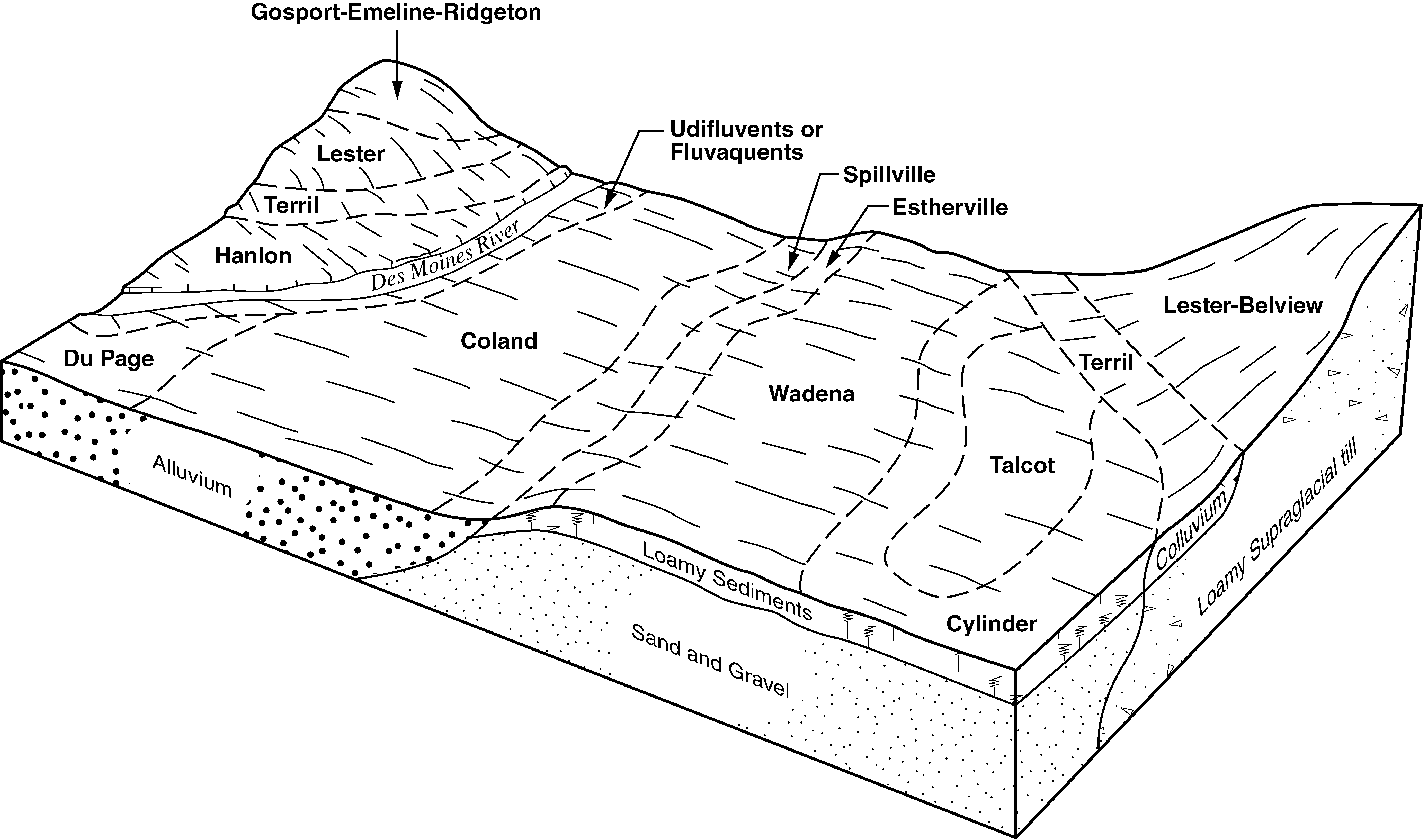
Gosport-Emeline-Ridgeton complex, 25 to 75 percent slopes | 413G | 2301 | 1612322 | 1r3rd | ia187 | 2006 | 1:12000 |
Hickory-Gosport complex, 15 to 30 percent slopes | 967F | 3572 | 173893 | 5tyg | il005 | 1981 | 1:12000 |
Hickory-Gosport complex, 18 to 35 percent slopes | 967F | 1623 | 2109200 | 28ssq | il025 | 1993 | 1:12000 |
Hickory-Gosport complex, 30 to 60 percent slopes | 967G | 35 | 174879 | 5vz8 | il035 | 1992 | 1:15840 |
Gosport loam, 35 to 50 percent slopes | 551G | 590 | 843571 | x9sz | il045 | 1997 | 1:12000 |
Gosport silt loam, 18 to 35 percent slopes | 551F | 130 | 843570 | x9sy | il045 | 1997 | 1:12000 |
Hickory-Gosport silt loams, 18 to 35 percent slopes | 967F | 5816 | 1586444 | 1q7tm | il079 | 2005 | 1:12000 |
Gosport silty clay loam, 4 to 7 percent slopes, eroded | 551C2 | 37 | 176744 | 5xxf | il101 | 1952 | 1:42240 |
Gosport silty clay loam, 7 to 12 percent slopes, severely eroded | 551D3 | 14 | 176745 | 5xxg | il101 | 1952 | 1:42240 |
Hickory-Gosport silt loams, 18 to 35 percent slopes | 967F | 582 | 198980 | 6p1q | il119 | 2001 | 1:12000 |
Hickory-Gosport silt loams, 18 to 35 percent slopes | 967F | 3375 | 2027383 | 261ng | il121 | 2008 | 1:12000 |
Gosport silt loam, 10 to 18 percent slopes, eroded | 551D2 | 1062 | 2027525 | 261t1 | il121 | 2008 | 1:12000 |
Gosport silt loam, 18 to 35 percent slopes | 551F | 324 | 2027527 | 261t3 | il121 | 2008 | 1:12000 |
Gosport silt loam, 35 to 60 percent slopes | 551G | 135 | 2027526 | 261t2 | il121 | 2008 | 1:12000 |
Gosport shaly silt loam, 50 to 70 percent slopes | GpG | 632 | 160438 | 5cyf | in165 | 1977 | 1:20000 |
Gosport channery silt loam, 25 to 40 percent slopes | GoF | 472 | 163115 | 5gqs | in171 | 1987 | 1:15840 |
Gosport silty clay loam, 25 to 45 percent slopes | 7951 | 6387 | 1475392 | 1lj89 | ks005 | 1998 | 1:24000 |
Knox-Gosport complex, 10 to 30 percent slopes | 7959 | 5739 | 1475395 | 1lj8d | ks005 | 1998 | 1:24000 |
Gosport-Sogn complex, 7 to 35 percent slopes | 7250 | 8035 | 1862364 | 20hy8 | ks103 | 1973 | 1:24000 |
Gosport complex, 10 to 30 percent slopes | 7950 | 3971 | 1862414 | 20hzw | ks103 | 1973 | 1:24000 |
Knox-Gosport complex, 10 to 30 percent slopes | 7959 | 243 | 1862420 | 20j02 | ks103 | 1973 | 1:24000 |
Gosport silty clay loam, 25 to 45 percent slopes | 7951 | 66 | 1862415 | 20hzx | ks103 | 1973 | 1:24000 |
Gosport-Sogn complex, 7 to 35 percent slopes | 7250 | 6487 | 1862252 | 20htn | ks209 | 1973 | 1:24000 |
Gosport complex, 10 to 30 percent slopes | 7950 | 74 | 1862302 | 20hw8 | ks209 | 1973 | 1:24000 |
Gosport silty clay loam, 15 to 45 percent slopes | 10155 | 4884 | 2528252 | 2ql0x | mo021 | 1984 | 1:24000 |
Gosport-Gasconade complex, 20 to 45 percent slopes | 10160 | 3435 | 913532 | znls | mo021 | 1984 | 1:24000 |
Gosport silty clay loam, 14 to 30 percent slopes | 30073 | 168 | 2531170 | 2qnqw | mo025 | 1967 | 1:24000 |
Gosport silt loam, 14 to 35 percent slopes | 30072 | 95 | 2531167 | 2qnqv | mo025 | 1967 | 1:24000 |
Gosport silty clay loam, 9 to 14 percent slopes | 30075 | 92 | 2531180 | 2qnqy | mo025 | 1967 | 1:24000 |
Gosport silt loam, 5 to 30 percent slopes | 50025 | 313 | 885961 | yqxd | mo027 | 1986 | 1:24000 |
Gosport silty clay loam, 9 to 14 percent slopes | 30075 | 13752 | 2531182 | 2qnqy | mo033 | 1988 | 1:24000 |
Gosport silty clay loam, 14 to 30 percent slopes | 30073 | 10280 | 2531171 | 2qnqw | mo033 | 1988 | 1:24000 |
Gosport silty clay loam, 5 to 9 percent slopes | 30074 | 2282 | 2531176 | 2qnqx | mo033 | 1988 | 1:24000 |
Gosport silt loam, 14 to 35 percent slopes | 30072 | 1809 | 2531166 | 2qnqv | mo033 | 1988 | 1:24000 |
Gosport silty clay loam, 14 to 30 percent slopes | 30073 | 6606 | 2531173 | 2qnqw | mo041 | 1992 | 1:24000 |
Gosport silty clay loam, 9 to 14 percent slopes, eroded | 30076 | 4275 | 2531186 | 2qnqz | mo041 | 1992 | 1:24000 |
Gosport silty clay loam, 15 to 45 percent slopes | 10155 | 64 | 2528251 | 2ql0x | mo049 | 1981 | 1:24000 |
Gosport-Gasconade complex, 14 to 30 percent slopes | 30071 | 88 | 2531164 | 2qnqt | mo061 | 1952 | 1:24000 |
Gosport-Gasconade complex, 14 to 30 percent slopes | 30071 | 2780 | 2531165 | 2qnqt | mo063 | 1974 | 1:24000 |
Gosport silty clay loam, 5 to 9 percent slopes | 30074 | 21 | 2531177 | 2qnqx | mo103 | 1973 | 1:24000 |
Gosport silty clay loam, 9 to 35 percent slopes, eroded | 30077 | 2292 | 2531188 | 2qnr0 | mo115 | 1987 | 1:24000 |
Gosport silty clay loam, 14 to 30 percent slopes | 30073 | 224 | 2531172 | 2qnqw | mo115 | 1987 | 1:24000 |
Gosport silty clay loam, 9 to 14 percent slopes, eroded | 30076 | 14 | 2531185 | 2qnqz | mo115 | 1987 | 1:24000 |
Gosport silt loam, 14 to 35 percent slopes | 30072 | 9928 | 2531168 | 2qnqv | mo117 | 1996 | 1:24000 |
Gosport silty clay loam, 9 to 14 percent slopes | 30075 | 214 | 2531181 | 2qnqy | mo117 | 1996 | 1:24000 |
Gosport loam, 14 to 20 percent slopes, eroded | 60111 | 3063 | 888558 | ytm5 | mo121 | 1991 | 1:24000 |
Gosport silty clay loam, 9 to 35 percent slopes, eroded | 30077 | 346 | 2531187 | 2qnr0 | mo121 | 1991 | 1:24000 |
Gosport silt loam, 14 to 30 percent slopes, eroded | 50024 | 61 | 2532671 | 2qnzb | mo121 | 1991 | 1:24000 |
Gosport silty clay loam, 14 to 30 percent slopes | 30073 | 21 | 2531174 | 2qnqw | mo121 | 1991 | 1:24000 |
Gosport silty clay loam, 9 to 14 percent slopes | 30075 | 2791 | 2531184 | 2qnqy | mo127 | 1982 | 1:24000 |
Gosport silty clay loam, 14 to 20 percent slopes | 50026 | 1766 | 2532674 | 2qnzc | mo127 | 1982 | 1:24000 |
Gosport silty clay loam, 14 to 20 percent slopes | 50026 | 2455 | 2532675 | 2qnzc | mo137 | 1973 | 1:24000 |
Gosport silty clay loam, 9 to 14 percent slopes | 30075 | 1920 | 2531183 | 2qnqy | mo137 | 1973 | 1:24000 |
Gosport silty clay loam, 5 to 9 percent slopes | 30074 | 1283 | 2531178 | 2qnqx | mo137 | 1973 | 1:24000 |
Gosport silt loam, 14 to 30 percent slopes, eroded | 50024 | 68 | 2532670 | 2qnzb | mo137 | 1973 | 1:24000 |
Gosport silty clay loam, 14 to 20 percent slopes | 50026 | 2157 | 2532673 | 2qnzc | mo173 | 1982 | 1:24000 |
Gosport silty clay loam, 9 to 14 percent slopes | 30075 | 1595 | 2531179 | 2qnqy | mo173 | 1982 | 1:24000 |
Gosport silt loam, 14 to 30 percent slopes, eroded | 50024 | 28447 | 2532672 | 2qnzb | mo175 | 1986 | 1:24000 |
Reger-Gosport complex, 14 to 35 percent slopes | 60197 | 7372 | 888604 | ytnn | mo175 | 1986 | 1:24000 |
Gosport silty clay loam, 14 to 30 percent slopes | 30073 | 282 | 2531169 | 2qnqw | mo175 | 1986 | 1:24000 |
Gosport silty clay loam, 5 to 9 percent slopes | 30074 | 22 | 2531175 | 2qnqx | mo205 | 1973 | 1:24000 |
Gosport silty clay loam, 25 to 70 percent slopes | GoF | 4445 | 286816 | 9mg4 | oh085 | 1976 | 1:15840 |