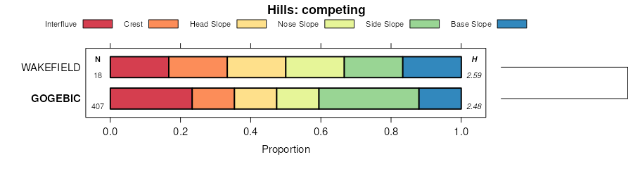
| Gogebic fine sandy loam, 1 to 6 percent slopes, stony | 310B | 59757 | 1456040 | 2tp01 | mi053 | 2007 | 1:24000 |
Tula-Gogebic complex, 0 to 6 percent slopes, stony | 311B | 52944 | 1702580 | 2xxjm | mi053 | 2007 | 1:24000 |
Gogebic fine sandy loam, 6 to 18 percent slopes, stony | 310C | 27595 | 1456041 | 2tp02 | mi053 | 2007 | 1:24000 |
Gogebic fine sandy loam, sandy substratum, 6 to 18 percent slopes, stony | 38C | 27376 | 1455937 | 2xxj8 | mi053 | 2007 | 1:24000 |
Gogebic silt loam, 6 to 18 percent slopes, stony | 317C | 24632 | 1456051 | 2xxjg | mi053 | 2007 | 1:24000 |
Gogebic fine sandy loam, sandy substratum, 1 to 6 percent slopes, stony | 38B | 23335 | 1455936 | 2xxj7 | mi053 | 2007 | 1:24000 |
Gogebic silt loam, 1 to 6 percent slopes, stony | 317B | 17054 | 1456050 | 2xxjf | mi053 | 2007 | 1:24000 |
Gogebic silt loam, sandy substratum, 6 to 18 percent slopes, stony | 39C | 16025 | 1455940 | 2xxjk | mi053 | 2007 | 1:24000 |
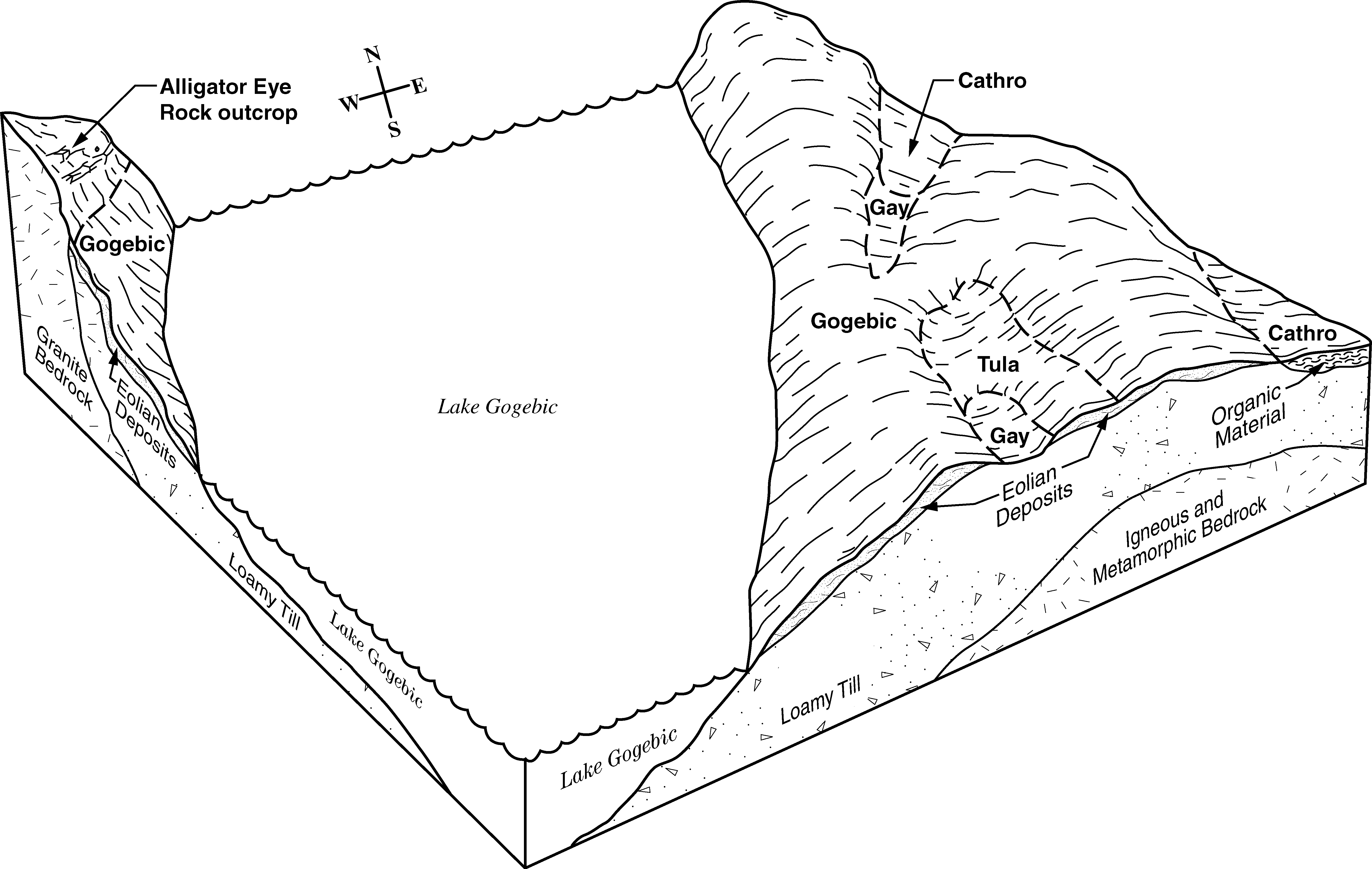
Gogebic-Peshekee complex, 6 to 18 percent slopes, very rocky, very stony | 429C | 14956 | 1456130 | 1kw6y | mi053 | 2007 | 1:24000 |
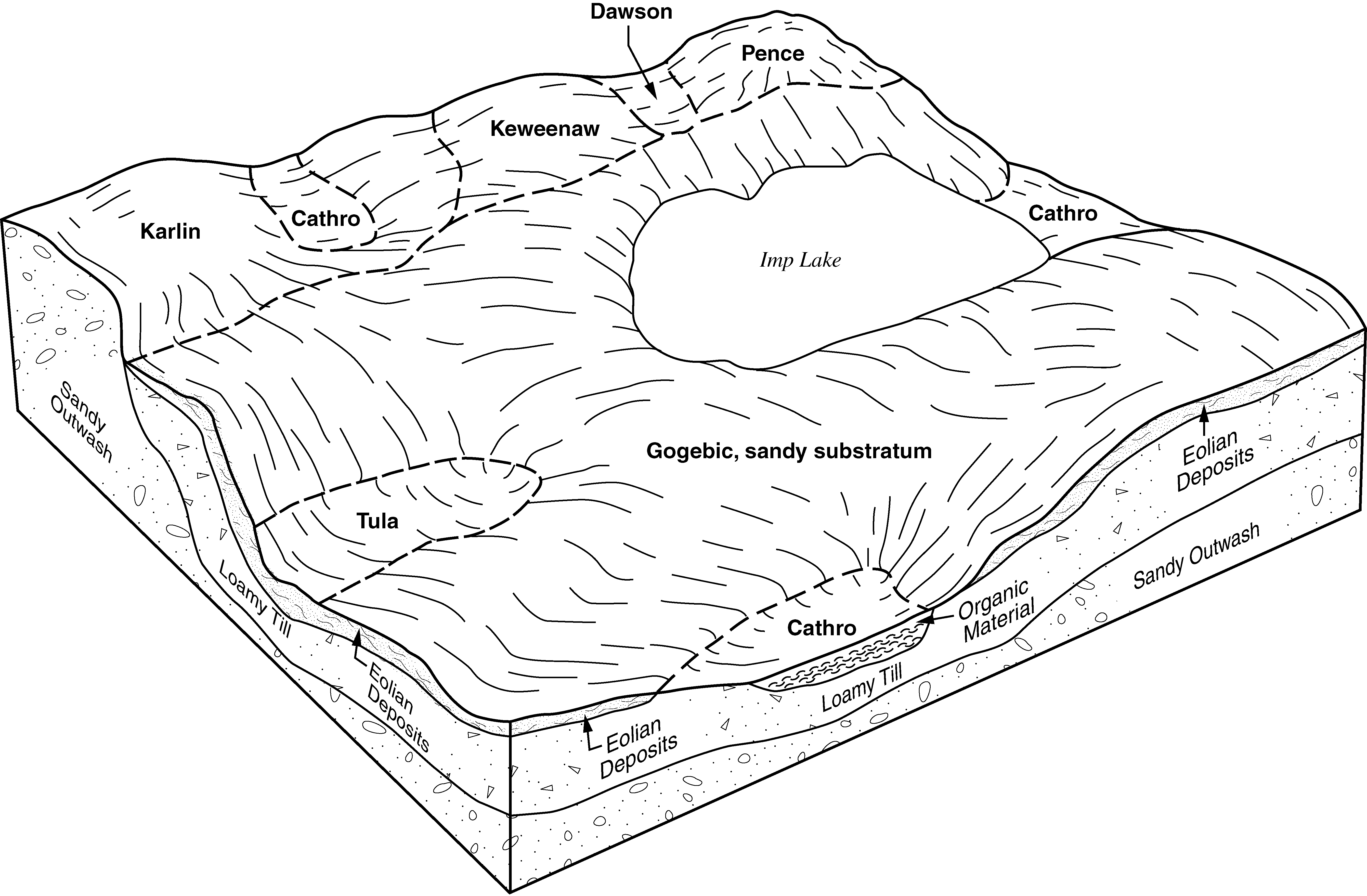
Gogebic-Tula-Lupton complex, 0 to 6 percent slopes | 37B | 13512 | 1455935 | 1kw0n | mi053 | 2007 | 1:24000 |
Gogebic silt loam, sandy substratum, 1 to 6 percent slopes, stony | 39B | 6406 | 1455939 | 2xxjj | mi053 | 2007 | 1:24000 |
Gogebic-Peshekee complex, 1 to 6 percent slopes, very rocky, very stony | 429B | 5605 | 1456129 | 1kw6x | mi053 | 2007 | 1:24000 |
Gogebic fine sandy loam, 6 to 18 percent slopes. very stony, rocky | 354C | 5076 | 1455978 | 2xxj5 | mi053 | 2007 | 1:24000 |
Gogebic silt loam, 12 to 35 percent slopes, very stony, rocky | 351D | 3994 | 1455973 | 2xxjd | mi053 | 2007 | 1:24000 |
Gogebic silt loam, 6 to 18 percent slopes, very stony, rocky | 351C | 3801 | 1455972 | 2xxjc | mi053 | 2007 | 1:24000 |
Gogebic, sandy substratum-Pence-Cathro complex, 0 to 18 percent slopes | 5172C | 3214 | 1455968 | 1kw1q | mi053 | 2007 | 1:24000 |
Gogebic-Tula-Chabeneau complex, 0 to 4 percent slopes | 511A | 3115 | 1456291 | 1kwd4 | mi053 | 2007 | 1:24000 |
Dishno-Gogebic-Peshekee-Rock outcrop complex, 18 to 35 percent slopes, very stony | 369D | 2961 | 1456000 | 1kw2r | mi053 | 2007 | 1:24000 |
Gogebic fine sandy loam, sandy substratum, 12 to 35 percent slopes, stony | 38D | 2728 | 1455938 | 2xxj9 | mi053 | 2007 | 1:24000 |
Gogebic silt loam, sandy substratum, 12 to 35 percent slopes, stony | 39D | 2595 | 1455941 | 2xxjl | mi053 | 2007 | 1:24000 |
Gogebic silt loam, 8 to 35 percent slopes, stony | 317D | 2522 | 1456052 | 2xxjh | mi053 | 2007 | 1:24000 |
Chabeneau-Channing-Gogebic complex, 0 to 6 percent slopes, stony | 689B | 2380 | 1456344 | 1kwfv | mi053 | 2007 | 1:24000 |
Gogebic-Michigamme-Rock outcrop complex, 6 to 35 percent slopes, very stony | 432D | 2235 | 1456142 | 1kw7b | mi053 | 2007 | 1:24000 |
Gogebic-Michigamme complex, 18 to 35 percent slopes, rocky, very stony | 428D | 2121 | 1456126 | 1kw6t | mi053 | 2007 | 1:24000 |
Gogebic-Michigamme complex, 2 to 18 percent slopes, rocky, very stony | 428C | 1952 | 1456125 | 1kw6s | mi053 | 2007 | 1:24000 |
Gogebic-Annalake complex, 1 to 6 percent slopes | 528B | 1175 | 1456316 | 1kwdy | mi053 | 2007 | 1:24000 |
Gogebic-Peshekee complex, 18 to 35 percent slopes, very rocky, very stony | 429D | 1145 | 1456131 | 1kw6z | mi053 | 2007 | 1:24000 |
Manido-Fence-Gogebic, sandy substratum, complex, 1 to 6 percent slopes | 296B | 942 | 1456174 | 1kw8c | mi053 | 2007 | 1:24000 |
Gogebic fine sandy loam, 1 to 6 percent slopes. very stony, rocky | 354B | 883 | 1455977 | 2xxj4 | mi053 | 2007 | 1:24000 |
Tula-Wormet-Gogebic, sandy substratum, complex, 0 to 6 percent slopes | 5171B | 753 | 1455966 | 1kw1n | mi053 | 2007 | 1:24000 |
Dishno-Gogebic-Peshekee-Rock outcrop complex, 6 to 18 percent slopes, very stony | 369C | 727 | 1455999 | 1kw2q | mi053 | 2007 | 1:24000 |
Gogebic, sandy substratum-Pence-Cathro complex, 0 to 6 percent slopes | 5172B | 706 | 1455967 | 1kw1p | mi053 | 2007 | 1:24000 |
Gogebic silt loam, 1 to 6 percent slopes, very stony, rocky | 351B | 685 | 1455971 | 2xxjb | mi053 | 2007 | 1:24000 |
Gogebic fine sandy loam, 12 to 35 percent slopes, very stony, rocky | 354D | 637 | 1455979 | 2xxj6 | mi053 | 2007 | 1:24000 |
Gogebic-Michigamme-Rock outcrop complex, 6 to 18 percent slopes, very stony | 432C | 438 | 1456141 | 1kw79 | mi053 | 2007 | 1:24000 |
Gogebic-Annalake complex, 18 to 35 percent slopes | 528D | 400 | 1456318 | 1kwf0 | mi053 | 2007 | 1:24000 |
Gogebic-Karlin complex, 1 to 6 percent slopes | 519B | 386 | 1456305 | 1kwdl | mi053 | 2007 | 1:24000 |
Manido-Sporley-Gogebic, sandy substratum, complex, 18 to 35 percent slopes | 296D | 300 | 1456175 | 1kw8d | mi053 | 2007 | 1:24000 |
Siskiwit-Gogebic complex, 1 to 6 percent slopes, stony | 325B | 206 | 1456069 | 1kw4z | mi053 | 2007 | 1:24000 |
Gogebic-Dishno complex, 1 to 6 percent slopes, rocky, very stony | 551B | 200 | 1456243 | 1kwbl | mi053 | 2007 | 1:24000 |
Gogebic, sandy substratum-Karlin complex, 6 to 35 percent slopes | 523D | 199 | 1456309 | 1kwdq | mi053 | 2007 | 1:24000 |
Gogebic, sandy substratum-Pence complex, 18 to 35 percent slopes | 5173D | 180 | 1455970 | 1kw1s | mi053 | 2007 | 1:24000 |
Gogebic, sandy substratum-Pence-Cathro complex, 0 to 35 percent slopes | 5172D | 177 | 1455969 | 1kw1r | mi053 | 2007 | 1:24000 |
Gogebic-Annalake complex, 6 to 18 percent slopes | 528C | 120 | 1456317 | 1kwdz | mi053 | 2007 | 1:24000 |
Gogebic-Karlin complex, 6 to 18 percent slopes | 519C | 82 | 1456306 | 1kwdm | mi053 | 2007 | 1:24000 |
Gogebic-Karlin complex, 18 to 35 percent slopes | 519D | 60 | 1456307 | 1kwdn | mi053 | 2007 | 1:24000 |
Siskiwit-Gogebic complex, 6 to 18 percent slopes, stony | 325C | 45 | 1456070 | 1kw50 | mi053 | 2007 | 1:24000 |
Gogebic fine sandy loam, sandy substratum, 1 to 6 percent slopes, stony | 8038B | 399 | 2485888 | 2xxj7 | mi061 | 1989 | 1:20000 |
Gogebic silt loam, sandy substratum, 1 to 6 percent slopes, stony | 8039B | 267 | 2485899 | 2xxjj | mi061 | 1989 | 1:20000 |
Gogebic fine sandy loam, sandy substratum, 6 to 18 percent slopes, stony | 8038C | 259 | 2485889 | 2xxj8 | mi061 | 1989 | 1:20000 |
Gogebic silt loam, sandy substratum, 6 to 18 percent slopes, stony | 8039C | 174 | 2485900 | 2xxjk | mi061 | 1989 | 1:20000 |
Gogebic fine sandy loam, 12 to 35 percent slopes, very stony, rocky | 8354D | 102 | 2485703 | 2xxj6 | mi061 | 1989 | 1:20000 |
Gogebic silt loam, 8 to 35 percent slopes, stony | 8317D | 100 | 2485852 | 2xxjh | mi061 | 1989 | 1:20000 |
Gogebic-Pence complex, 6 to 35 percent slopes, very rocky, stony | 8034D | 95 | 2485694 | 2pfkp | mi061 | 1989 | 1:20000 |
Gogebic fine sandy loam, 6 to 18 percent slopes, stony | 8310C | 82 | 2485726 | 2tp02 | mi061 | 1989 | 1:20000 |
Gogebic fine sandy loam, 1 to 6 percent slopes, stony | 8310B | 82 | 2485725 | 2tp01 | mi061 | 1989 | 1:20000 |
Gogebic silt loam, 6 to 18 percent slopes, stony | 8317C | 77 | 2485851 | 2xxjg | mi061 | 1989 | 1:20000 |
Gogebic-Tula-Lupton complex, 0 to 6 percent slopes | 8037B | 57 | 2485861 | 2pfr2 | mi061 | 1989 | 1:20000 |
Gogebic silt loam, 1 to 6 percent slopes, stony | 8317B | 25 | 2485781 | 2xxjf | mi061 | 1989 | 1:20000 |
Gogebic fine sandy loam, sandy substratum, 12 to 35 percent slopes, stony | 8038D | 25 | 2485890 | 2xxj9 | mi061 | 1989 | 1:20000 |
Gogebic silt loam, 12 to 35 percent slopes, very stony, rocky | 8351D | 18 | 2485700 | 2xxjd | mi061 | 1989 | 1:20000 |
Dishno-Gogebic-Peshekee-Rock outcrop complex, 6 to 18 percent slopes, very stony | 8369C | 15 | 2485818 | 2pfpp | mi061 | 1989 | 1:20000 |
Gogebic silt loam, sandy substratum, 12 to 35 percent slopes, stony | 8039D | 7 | 2485901 | 2xxjl | mi061 | 1989 | 1:20000 |
Dishno-Gogebic-Peshekee-Rock outcrop complex, 18 to 35 percent slopes, very stony | 8369D | 6 | 2485819 | 2pfpq | mi061 | 1989 | 1:20000 |
Gogebic silt loam, 6 to 18 percent slopes, very stony, rocky | 8351C | 1 | 2485723 | 2xxjc | mi061 | 1989 | 1:20000 |
Gogebic silt loam, 1 to 6 percent slopes, very stony, rocky | 8351B | 1 | 2485722 | 2xxjb | mi061 | 1989 | 1:20000 |
Gogebic fine sandy loam, sandy substratum, 1 to 6 percent slopes, stony | 38B | 2618 | 2452521 | 2xxj7 | mi071 | 1992 | 1:20000 |
Gogebic fine sandy loam, sandy substratum, 6 to 18 percent slopes, stony | 38C | 2443 | 2452522 | 2xxj8 | mi071 | 1992 | 1:20000 |
Gogebic-Pence complex, 6 to 35 percent slopes, very rocky, stony | 8034D | 2108 | 2452518 | 2nb1h | mi071 | 1992 | 1:20000 |
Gogebic-Tula-Lupton complex, 0 to 6 percent slopes | 37B | 1548 | 2452520 | 2nb1k | mi071 | 1992 | 1:20000 |
Gogebic fine sandy loam, sandy substratum, 12 to 35 percent slopes, stony | 38D | 140 | 2452523 | 2xxj9 | mi071 | 1992 | 1:20000 |
Gogebic silt loam, sandy substratum, 1 to 6 percent slopes, stony | 39B | 60 | 2452527 | 2xxjj | mi071 | 1992 | 1:20000 |
Gogebic silt loam, sandy substratum, 6 to 18 percent slopes, stony | 39C | 28 | 2452528 | 2xxjk | mi071 | 1992 | 1:20000 |
Gogebic-Dishno cobbly silt loams, 6 to 18 percent slopes, rocky, very stony | 124D | 4962 | 395012 | f81b | mi103 | 1999 | 1:24000 |
Gogebic cobbly silt loam, 1 to 6 percent slopes, very stony | 73B | 2965 | 395259 | f899 | mi103 | 1999 | 1:24000 |
Tula-Gogebic complex, 0 to 6 percent slopes, stony | 204B | 926 | 395161 | 2xxjm | mi103 | 1999 | 1:24000 |
Gogebic cobbly silt loam, 6 to 18 percent slopes, very stony | 73D | 834 | 395260 | f89b | mi103 | 1999 | 1:24000 |
Gogebic-Dishno cobbly silt loams, 1 to 6 percent slopes, rocky, very stony | 124B | 404 | 395011 | f819 | mi103 | 1999 | 1:24000 |
Gogebic fine sandy loam, 1 to 6 percent slopes, stony | 8310B | 12262 | 1674906 | 2tp01 | mi131 | 2007 | 1:24000 |
Gogebic silt loam, 6 to 18 percent slopes, stony | 8317C | 11775 | 1674915 | 2xxjg | mi131 | 2007 | 1:24000 |
Tula-Gogebic complex, 0 to 6 percent slopes, stony | 8311B | 11022 | 1674909 | 2xxjm | mi131 | 2007 | 1:24000 |
Gogebic silt loam, 1 to 6 percent slopes, stony | 8317B | 9049 | 1674914 | 2xxjf | mi131 | 2007 | 1:24000 |
Gogebic fine sandy loam, 6 to 18 percent slopes, stony | 8310C | 8399 | 1674907 | 2tp02 | mi131 | 2007 | 1:24000 |
Gogebic fine sandy loam, sandy substratum, 6 to 18 percent slopes, stony | 8038C | 4803 | 1674497 | 2xxj8 | mi131 | 2007 | 1:24000 |
Gogebic fine sandy loam, sandy substratum, 1 to 6 percent slopes, stony | 8038B | 4686 | 1674496 | 2xxj7 | mi131 | 2007 | 1:24000 |
Gogebic silt loam, sandy substratum, 1 to 6 percent slopes, stony | 8039B | 4671 | 1674499 | 2xxjj | mi131 | 2007 | 1:24000 |
Gogebic silt loam, sandy substratum, 6 to 18 percent slopes, stony | 8039C | 3307 | 1674500 | 2xxjk | mi131 | 2007 | 1:24000 |
Gogebic silt loam, 12 to 35 percent slopes, very stony, rocky | 8351D | 2867 | 1674933 | 2xxjd | mi131 | 2007 | 1:24000 |
Gogebic silt loam, 6 to 18 percent slopes, very stony, rocky | 8351C | 2570 | 1674932 | 2xxjc | mi131 | 2007 | 1:24000 |
Gogebic fine sandy loam, 12 to 35 percent slopes, very stony, rocky | 8354D | 1783 | 1674937 | 2xxj6 | mi131 | 2007 | 1:24000 |
Gogebic-Tula-Lupton complex, 0 to 6 percent slopes | 8037B | 1620 | 1674495 | 1t6fz | mi131 | 2007 | 1:24000 |
Gogebic fine sandy loam, 6 to 18 percent slopes. very stony, rocky | 8354C | 1403 | 1674936 | 2xxj5 | mi131 | 2007 | 1:24000 |
Gogebic silt loam, 8 to 35 percent slopes, stony | 8317D | 930 | 1674916 | 2xxjh | mi131 | 2007 | 1:24000 |
Dishno-Gogebic-Peshekee-Rock outcrop complex, 18 to 35 percent slopes, very stony | 8369D | 927 | 1674940 | 1t6xb | mi131 | 2007 | 1:24000 |
Siskiwit-Gogebic complex, 1 to 6 percent slopes, stony | 8325B | 671 | 1674924 | 1t6wt | mi131 | 2007 | 1:24000 |
Gogebic-Moquah, frequently flooded, complex, 0 to 55 percent slopes, very rocky | 8367E | 504 | 1674938 | 1t6x8 | mi131 | 2007 | 1:24000 |
Gogebic fine sandy loam, sandy substratum, 12 to 35 percent slopes, stony | 8038D | 500 | 1674498 | 2xxj9 | mi131 | 2007 | 1:24000 |
Gogebic silt loam, 1 to 6 percent slopes, very stony, rocky | 8351B | 336 | 1674931 | 2xxjb | mi131 | 2007 | 1:24000 |
Gogebic fine sandy loam, 1 to 6 percent slopes. very stony, rocky | 8354B | 328 | 1674935 | 2xxj4 | mi131 | 2007 | 1:24000 |
Sarona, dense substratum-Gogebic, sandy substratum-Graveraet complex, 12 to 35 percent slopes | 8294D | 242 | 1674899 | 1t6w0 | mi131 | 2007 | 1:24000 |
Siskiwit-Gogebic complex, 6 to 18 percent slopes, stony | 8325C | 227 | 1674925 | 1t6wv | mi131 | 2007 | 1:24000 |
Dishno-Gogebic-Peshekee-Rock outcrop complex, 6 to 18 percent slopes, very stony | 8369C | 108 | 1674939 | 1t6x9 | mi131 | 2007 | 1:24000 |
Gogebic silt loam, sandy substratum, 12 to 35 percent slopes, stony | 8039D | 82 | 1674501 | 2xxjl | mi131 | 2007 | 1:24000 |
Gogebic-Peshekee complex, 6 to 18 percent slopes, very rocky, very stony | 8429C | 70 | 1674953 | 1t6xr | mi131 | 2007 | 1:24000 |
Gogebic-Pence complex, 6 to 35 percent slopes, very rocky, stony | 8034D | 59 | 1674492 | 1t6fw | mi131 | 2007 | 1:24000 |
Gogebic-Peshekee complex, 1 to 6 percent slopes, very rocky, very stony | 8429B | 16 | 1674952 | 1t6xq | mi131 | 2007 | 1:24000 |
Gogebic, very stony-Pence, very stony-Cathro complex, 0 to 18 percent slopes | 5172C | 37139 | 1702853 | 1v4yr | wi003 | 2006 | 1:12000 |
Gogebic-Metonga-Rock outcrop complex, 10 to 35 percent slopes, very stony | 5809E | 11246 | 1444491 | 1kh3h | wi003 | 2006 | 1:12000 |
Tula-Wormet-Gogebic complex, 0 to 6 percent slopes, very stony | 5171B | 11127 | 1702851 | 1v4yp | wi003 | 2006 | 1:12000 |
Gogebic-Metonga-Rock outcrop complex, 6 to 18 percent slopes, very stony | 5809D | 7559 | 1444490 | 1kh3g | wi003 | 2006 | 1:12000 |
Gogebic, very stony-Pence, very stony-Cathro complex, 0 to 6 percent slopes | 5172B | 7478 | 1702852 | 1v4yq | wi003 | 2006 | 1:12000 |
Gogebic silt loam, 6 to 18 percent slopes, very stony, rocky | 5351D | 6395 | 1702857 | 2xxjc | wi003 | 2006 | 1:12000 |
Gogebic-Pence complex, 18 to 35 percent slopes, very stony | 5173E | 5469 | 1702855 | 1v4yt | wi003 | 2006 | 1:12000 |
Gogebic silt loam, 12 to 35 percent slopes, very stony, rocky | 5351E | 2726 | 1702858 | 2xxjd | wi003 | 2006 | 1:12000 |
Tula-Gogebic complex, 0 to 6 percent slopes, stony | 5353B | 2179 | 1702860 | 2xxjm | wi003 | 2006 | 1:12000 |
Gogebic silt loam, 1 to 6 percent slopes, very stony, rocky | 5351B | 1833 | 1702856 | 2xxjb | wi003 | 2006 | 1:12000 |
Gogebic, very stony-Pence, very stony-Cathro complex, 0 to 35 percent slopes | 5172D | 1793 | 1702854 | 1v4ys | wi003 | 2006 | 1:12000 |
Gogebic fine sandy loam, 1 to 6 percent slopes. very stony, rocky | 5354B | 1421 | 1702862 | 2xxj4 | wi003 | 2006 | 1:12000 |
Pence-Gogebic complex, 2 to 6 percent slopes, stony | 5519B | 1036 | 1702874 | 1v4zf | wi003 | 2006 | 1:12000 |
Chabeneau-Channing-Gogebic complex, 0 to 6 percent slopes, stony | 5689B | 573 | 1702884 | 1v4zr | wi003 | 2006 | 1:12000 |
Dishno-Gogebic-Peshekee-Rock outcrop complex, 18 to 35 percent slopes, very stony | 5869E | 423 | 1702869 | 1v4z8 | wi003 | 2006 | 1:12000 |
Pence-Gogebic complex, 6 to 18 percent slopes, stony | 5519D | 382 | 1702876 | 1v4zh | wi003 | 2006 | 1:12000 |
Gogebic, very stony-Annalake complex, 0 to 6 percent slopes | 6145B | 177 | 1444523 | 1kh4j | wi003 | 2006 | 1:12000 |
Gogebic, very stony-Annalake complex, 6 to 15 percent slopes | 6145C | 169 | 1444524 | 1kh4k | wi003 | 2006 | 1:12000 |
Gogebic fine sandy loam, 1 to 6 percent slopes, stony | 5427B | 148 | 1444432 | 2tp01 | wi003 | 2006 | 1:12000 |
Pence-Gogebic complex, 18 to 35 percent slopes, stony | 5519E | 30 | 1702878 | 1v4zk | wi003 | 2006 | 1:12000 |
Gogebic fine sandy loam, 1 to 6 percent slopes, stony | 5427B | 32883 | 434700 | 2tp01 | wi007 | 2005 | 1:12000 |
Gogebic, very stony-Pence, very stony-Cathro complex, 0 to 18 percent slopes | 5172C | 31671 | 1147454 | 17j0n | wi007 | 2005 | 1:12000 |
Gogebic, very stony-Pence, very stony-Cathro complex, 0 to 6 percent slopes | 5172B | 12194 | 1380245 | 1hb81 | wi007 | 2005 | 1:12000 |
Gogebic-Metonga-Rock outcrop complex, 10 to 35 percent slopes, very stony | 5809E | 8531 | 1383908 | 1hg26 | wi007 | 2005 | 1:12000 |
Gogebic-Pence complex, 18 to 35 percent slopes, very stony | 5173E | 4576 | 1146422 | 17gyc | wi007 | 2005 | 1:12000 |
Tula-Wormet-Gogebic complex, 0 to 6 percent slopes, very stony | 5171B | 3113 | 1147453 | 17j0m | wi007 | 2005 | 1:12000 |
Gogebic, very stony-Pence, very stony-Cathro complex, 0 to 35 percent slopes | 5172D | 1478 | 1147455 | 17j0p | wi007 | 2005 | 1:12000 |
Gogebic fine sandy loam, 6 to 18 percent slopes, stony | 5427D | 613 | 434701 | 2tp02 | wi007 | 2005 | 1:12000 |
Gogebic-Metonga-Rock outcrop complex, 6 to 18 percent slopes, very stony | 5809D | 544 | 1383907 | 1hg25 | wi007 | 2005 | 1:12000 |
Gogebic, very stony-Annalake complex, 0 to 6 percent slopes | 6145B | 414 | 433555 | gk4n | wi007 | 2005 | 1:12000 |
Gogebic, very stony-Annalake complex, 6 to 15 percent slopes | 6145C | 296 | 433556 | gk4p | wi007 | 2005 | 1:12000 |
Gogebic, very stony-Pence, very stony-Cathro complex, 0 to 18 percent slopes | 5172C | 61535 | 1532144 | 1nfb0 | wi051 | 2006 | 1:12000 |
Gogebic, very stony-Pence, very stony-Cathro complex, 0 to 6 percent slopes | 5172B | 22727 | 1532143 | 1nf9z | wi051 | 2006 | 1:12000 |
Tula-Wormet-Gogebic complex, 0 to 6 percent slopes, very stony | 5171B | 22240 | 1532142 | 1nf9y | wi051 | 2006 | 1:12000 |
Gogebic silt loam, 6 to 18 percent slopes, very stony, rocky | 5351D | 22120 | 1532159 | 2xxjc | wi051 | 2006 | 1:12000 |
Tula-Gogebic complex, 0 to 6 percent slopes, stony | 5353B | 13800 | 1702591 | 2xxjm | wi051 | 2006 | 1:12000 |
Gogebic silt loam, 1 to 6 percent slopes, very stony, rocky | 5351B | 9121 | 1532158 | 2xxjb | wi051 | 2006 | 1:12000 |
Gogebic silt loam, 12 to 35 percent slopes, very stony, rocky | 5351E | 5557 | 1532160 | 2xxjd | wi051 | 2006 | 1:12000 |
Chabeneau-Channing-Gogebic complex, 0 to 6 percent slopes, stony | 5689B | 4621 | 1532191 | 1nfcj | wi051 | 2006 | 1:12000 |
Gogebic-Peshekee complex, 6 to 18 percent slopes, very stony, very rocky | 5429D | 4611 | 1532168 | 1nfbs | wi051 | 2006 | 1:12000 |
Gogebic-Peshekee complex, 2 to 6 percent slopes, very stony, very rocky | 5429B | 3716 | 1532167 | 1nfbr | wi051 | 2006 | 1:12000 |
Pence-Gogebic complex, 2 to 6 percent slopes, stony | 5519B | 3690 | 1532175 | 1nfc0 | wi051 | 2006 | 1:12000 |
Gogebic, very stony-Pence, very stony-Cathro complex, 0 to 35 percent slopes | 5172D | 3464 | 1532145 | 1nfb1 | wi051 | 2006 | 1:12000 |
Pence-Gogebic complex, 6 to 18 percent slopes, stony | 5519D | 3281 | 1532176 | 1nfc1 | wi051 | 2006 | 1:12000 |
Gogebic-Pence complex, 18 to 35 percent slopes, very stony | 5173E | 2629 | 782135 | v7w5 | wi051 | 2006 | 1:12000 |
Dishno-Gogebic-Peshekee-Rock outcrop complex, 18 to 35 percent slopes, very stony | 5869E | 2238 | 1700781 | 1v2sx | wi051 | 2006 | 1:12000 |
Gogebic, very stony-Pence, very stony-Cathro complex, 0 to 18 percent slopes, rocky | 5175C | 1409 | 1702443 | 1v4jj | wi051 | 2006 | 1:12000 |
Gogebic fine sandy loam, 1 to 6 percent slopes, stony | 5427B | 1082 | 1532152 | 2tp01 | wi051 | 2006 | 1:12000 |
Gogebic-Michigamme-Rock outcrop complex, 6 to 35 percent slopes, very stony | 5432E | 671 | 1532171 | 1nfbw | wi051 | 2006 | 1:12000 |
Gogebic silt loam, 6 to 18 percent slopes, stony | 5317D | 645 | 1532156 | 2xxjg | wi051 | 2006 | 1:12000 |
Gogebic silt loam, 1 to 6 percent slopes, stony | 5317B | 594 | 1532155 | 2xxjf | wi051 | 2006 | 1:12000 |
Gogebic-Michigamme-Rock outcrop complex, 6 to 18 percent slopes, very stony | 5432D | 555 | 1532170 | 1nfbv | wi051 | 2006 | 1:12000 |
Pence-Gogebic complex, 18 to 35 percent slopes, stony | 5519E | 487 | 1532177 | 1nfc2 | wi051 | 2006 | 1:12000 |
Gogebic fine sandy loam, 6 to 18 percent slopes, stony | 5427D | 358 | 1532153 | 2tp02 | wi051 | 2006 | 1:12000 |
Gogebic fine sandy loam, 1 to 6 percent slopes. very stony, rocky | 5354B | 321 | 1700780 | 2xxj4 | wi051 | 2006 | 1:12000 |
Gogebic silt loam, 8 to 35 percent slopes, stony | 5317E | 310 | 1532157 | 2xxjh | wi051 | 2006 | 1:12000 |
Gogebic, very stony-Pence, very stony-Cathro complex, 0 to 35 percent slopes, rocky | 5175D | 213 | 1702444 | 1v4jk | wi051 | 2006 | 1:12000 |
Gogebic-Peshekee complex, 18 to 35 percent slopes, very stony, very rocky | 5429E | 174 | 1532169 | 1nfbt | wi051 | 2006 | 1:12000 |
Gogebic-Fence-Pence complex, 3 to 15 percent slopes | 5972C | 22098 | 421239 | g4bc | wi125 | 1985 | 1:20000 |
Gogebic-Pence complex, 15 to 30 percent slopes | 5972E | 17408 | 421240 | g4bd | wi125 | 1985 | 1:20000 |
Gogebic-Fence-Pence complex, 0 to 6 percent slopes | 5972B | 7666 | 421238 | g4bb | wi125 | 1985 | 1:20000 |


