| Gloucester gravelly sandy loam, 15 to 35 percent slopes, extremely stony | 59D | 1772 | 3395785 | 9lpl | ct601 | 2003 | 1:12000 |
Gloucester gravelly sandy loam, 3 to 15 percent slopes, extremely stony | 59C | 1700 | 3395784 | 9lpk | ct601 | 2003 | 1:12000 |
Gloucester gravelly sandy loam, 8 to 15 percent slopes, very stony | 58C | 1620 | 3395783 | 9lpj | ct601 | 2003 | 1:12000 |
Gloucester gravelly sandy loam, 3 to 8 percent slopes | 57B | 1095 | 3395779 | 9lpd | ct601 | 2003 | 1:12000 |
Gloucester gravelly sandy loam, 8 to 15 percent slopes | 57C | 1050 | 3395780 | 9lpf | ct601 | 2003 | 1:12000 |
Gloucester gravelly sandy loam, 3 to 8 percent slopes, very stony | 58B | 866 | 3395782 | 9lph | ct601 | 2003 | 1:12000 |
Gloucester gravelly sandy loam, 15 to 25 percent slopes | 57D | 381 | 3395781 | 9lpg | ct601 | 2003 | 1:12000 |
Gloucester gravelly sandy loam, 3 to 15 percent slopes, extremely stony | 59C | 2927 | 3400157 | 9lpk | ct602 | 2003 | 1:12000 |
Gloucester gravelly sandy loam, 3 to 8 percent slopes, very stony | 58B | 1724 | 3400155 | 9lph | ct602 | 2003 | 1:12000 |
Gloucester gravelly sandy loam, 8 to 15 percent slopes, very stony | 58C | 1569 | 3400156 | 9lpj | ct602 | 2003 | 1:12000 |
Gloucester gravelly sandy loam, 15 to 35 percent slopes, extremely stony | 59D | 1201 | 3400158 | 9lpl | ct602 | 2003 | 1:12000 |
Gloucester gravelly sandy loam, 3 to 8 percent slopes | 57B | 1100 | 3400152 | 9lpd | ct602 | 2003 | 1:12000 |
Gloucester gravelly sandy loam, 8 to 15 percent slopes | 57C | 1076 | 3400153 | 9lpf | ct602 | 2003 | 1:12000 |
Gloucester gravelly sandy loam, 15 to 25 percent slopes | 57D | 63 | 3400154 | 9lpg | ct602 | 2003 | 1:12000 |
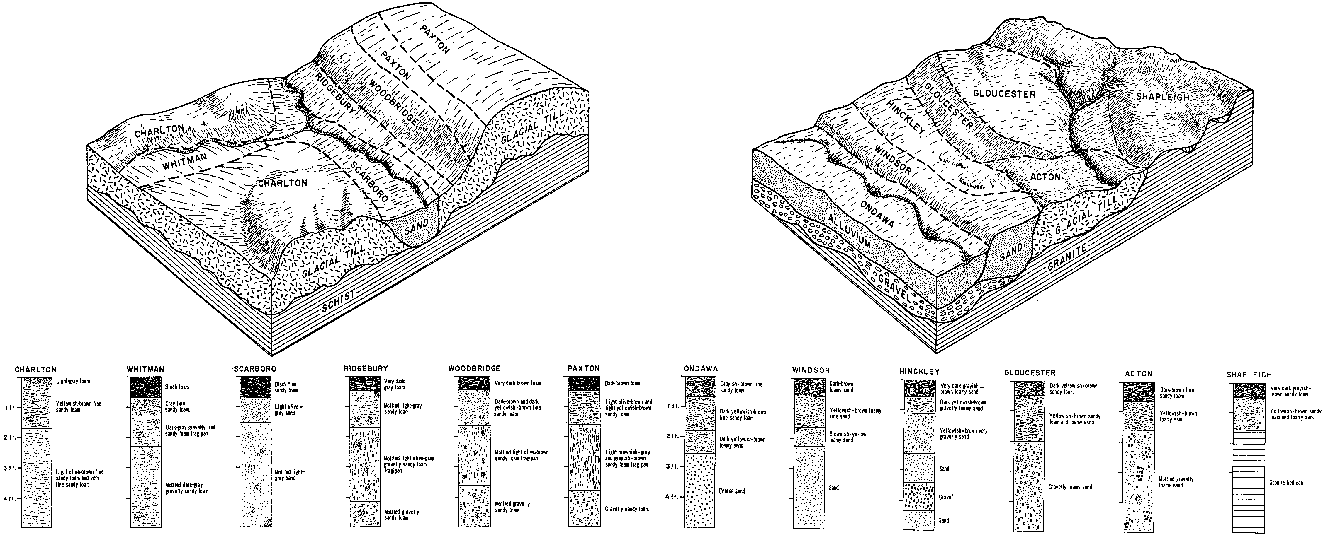
Gloucester sandy loam, 8 to 15 percent slopes, very stony | 441C | 843 | 278928 | 9c7p | ma011 | 2012 | 1:12000 |
Gloucester sandy loam, 3 to 8 percent slopes, very stony | 441B | 626 | 278927 | 9c7n | ma011 | 2012 | 1:12000 |
Gloucester sandy loam, 8 to 15 percent slopes | 440C | 532 | 278925 | 9c7l | ma011 | 2012 | 1:12000 |
Gloucester sandy loam, 15 to 25 percent slopes, very stony | 441D | 525 | 278929 | 9c7q | ma011 | 2012 | 1:12000 |
Gloucester sandy loam, 25 to 45 percent slopes, very stony | 441F | 515 | 279066 | 9cd4 | ma011 | 2012 | 1:12000 |
Gloucester sandy loam, 3 to 8 percent slopes | 440B | 317 | 278924 | 9c7k | ma011 | 2012 | 1:12000 |
Gloucester sandy loam, 15 to 25 percent slopes | 440D | 258 | 278926 | 9c7m | ma011 | 2012 | 1:12000 |
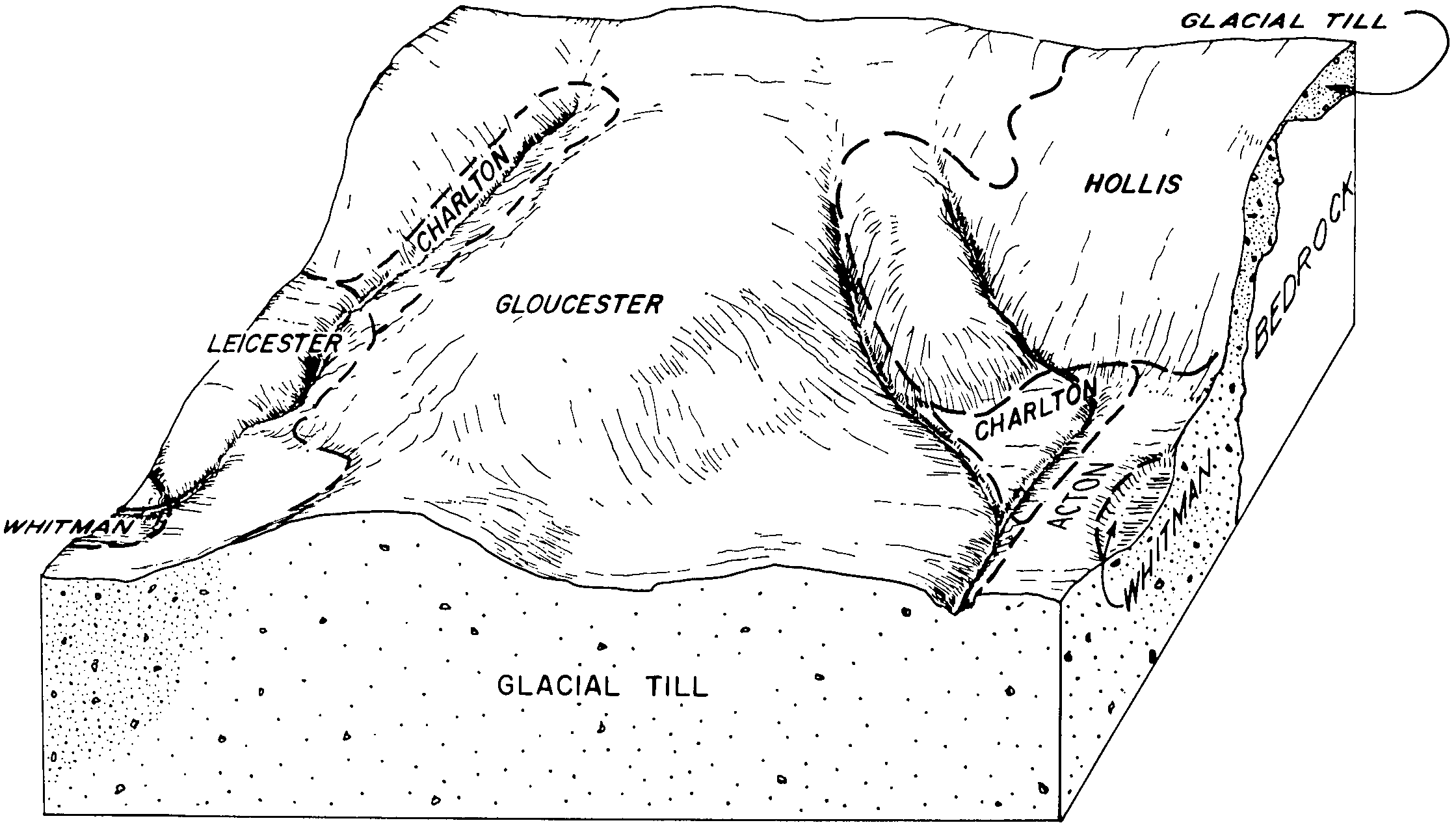
Gloucester - Canton complex, 8 to 15 percent slopes, extremely bouldery | 453C | 1091 | 309486 | bd1f | ma023 | 2010 | 1:12000 |
Gloucester - Canton complex, 3 to 8 percent slopes, extremely bouldery | 453B | 680 | 309483 | bd1b | ma023 | 2010 | 1:12000 |
Gloucester - Canton complex, 3 to 8 percent slopes | 439B | 478 | 309482 | bd19 | ma023 | 2010 | 1:12000 |
Gloucester - Canton complex, 15 to 35 percent slopes, extremely bouldery | 453E | 316 | 309485 | bd1d | ma023 | 2010 | 1:12000 |
Gloucester - Canton complex, 8 to 15 percent slopes | 439C | 220 | 309481 | bd18 | ma023 | 2010 | 1:12000 |
Gloucester - Canton complex, 15 to 35 percent slopes | 439E | 90 | 309484 | bd1c | ma023 | 2010 | 1:12000 |
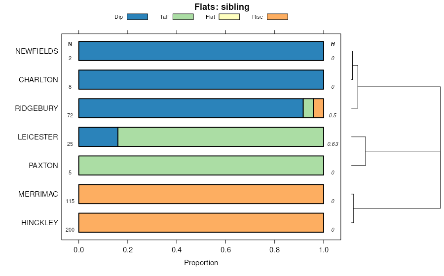
Gloucester-Hinckley complex, 3 to 8 percent slopes, very stony | 446B | 3052 | 779970 | 2svln | ma603 | 1979 | 1:20000 |
Gloucester-Hinckley complex, 8 to 15 percent slopes, very stony | 446C | 1486 | 779975 | 2svlq | ma603 | 1979 | 1:20000 |
Gloucester-Hinckley complex, 3 to 8 percent slopes | 449B | 651 | 779965 | 2svlr | ma603 | 1979 | 1:20000 |
Gloucester sandy loam, 8 to 15 percent slopes, extremely stony | 442C | 202 | 277424 | 99p5 | ma607 | 1975 | 1:15840 |
Gloucester sandy loam, 15 to 25 percent slopes, extremely stony | 442D | 160 | 277425 | 99p6 | ma607 | 1975 | 1:15840 |
Gloucester sandy loam, 3 to 8 percent slopes, very stony | 441B | 146 | 277420 | 99p1 | ma607 | 1975 | 1:15840 |
Gloucester sandy loam, 3 to 8 percent slopes | 440B | 123 | 277419 | 99p0 | ma607 | 1975 | 1:15840 |
Gloucester sandy loam, 3 to 8 percent slopes, extremely stony | 442B | 77 | 277423 | 99p4 | ma607 | 1975 | 1:15840 |
Gloucester sandy loam, 8 to 15 percent slopes, very stony | 441C | 63 | 277421 | 99p2 | ma607 | 1975 | 1:15840 |
Gloucester fine sandy loam, 8 to 15 percent slopes, very stony | 441C | 1061 | 277729 | 9b00 | ma609 | 1980 | 1:15840 |
Gloucester fine sandy loam, 3 to 8 percent slopes, very stony | 441B | 856 | 277728 | 99zz | ma609 | 1980 | 1:15840 |
Gloucester fine sandy loam, 15 to 25 percent slopes, very stony | 441D | 694 | 277730 | 9b01 | ma609 | 1980 | 1:15840 |
Gloucester fine sandy loam, 3 to 8 percent slopes, stony | 534B | 383 | 277726 | 99zx | ma609 | 1980 | 1:15840 |
Charlton and Gloucester fine sandy loams, 25 to 35 percent slopes , very stony | 743E | 339 | 277714 | 99zj | ma609 | 1980 | 1:15840 |
Gloucester fine sandy loam, 8 to 15 percent slopes, stony | 534C | 221 | 277727 | 99zy | ma609 | 1980 | 1:15840 |
Gloucester fine sandy loam, 3 to 8 percent slopes | 440B | 208 | 277724 | 99zv | ma609 | 1980 | 1:15840 |
Gloucester fine sandy loam, 8 to 15 percent slopes | 440C | 133 | 277725 | 99zw | ma609 | 1980 | 1:15840 |
Gloucester fine sandy loam, 15 to 25 percent slopes, extremely stony | 442D | 0 | 1903847 | 21x3f | ma609 | 1980 | 1:15840 |
Gloucester and Canton soils, steep, extremely stony | 447E | 3757 | 789781 | vhtt | ma610 | 1985 | 1:25000 |
Gloucester gravelly fine sandy loam, 8 to 15 percent slopes, extremely stony | 442C | 2775 | 789772 | vhtj | ma610 | 1985 | 1:25000 |
Gloucester gravelly fine sandy loam, 15 to 25 percent slopes, extremely stony | 442D | 1788 | 789776 | vhtn | ma610 | 1985 | 1:25000 |
Gloucester gravelly fine sandy loam, 3 to 8 percent slopes, extremely stony | 442B | 1458 | 789770 | vhtg | ma610 | 1985 | 1:25000 |
Gloucester gravelly fine sandy loam, 3 to 8 percent slopes, very stony | 441B | 668 | 789765 | vht9 | ma610 | 1985 | 1:25000 |
Gloucester gravelly fine sandy loam, 8 to 15 percent slopes, very stony | 441C | 557 | 789768 | vhtd | ma610 | 1985 | 1:25000 |
Gloucester gravelly fine sandy loam, 3 to 8 percent slopes | 440B | 263 | 789763 | vht7 | ma610 | 1985 | 1:25000 |
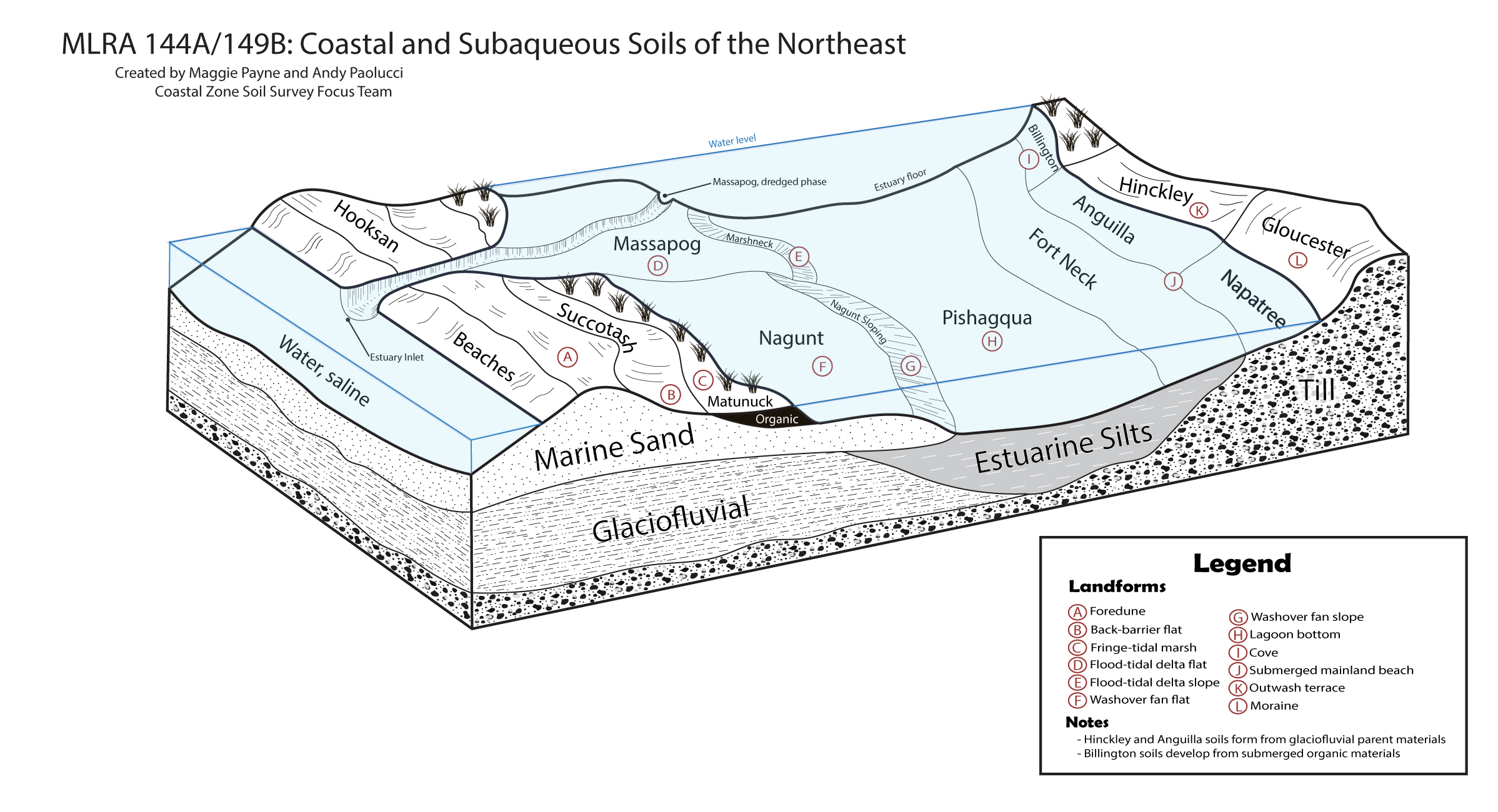
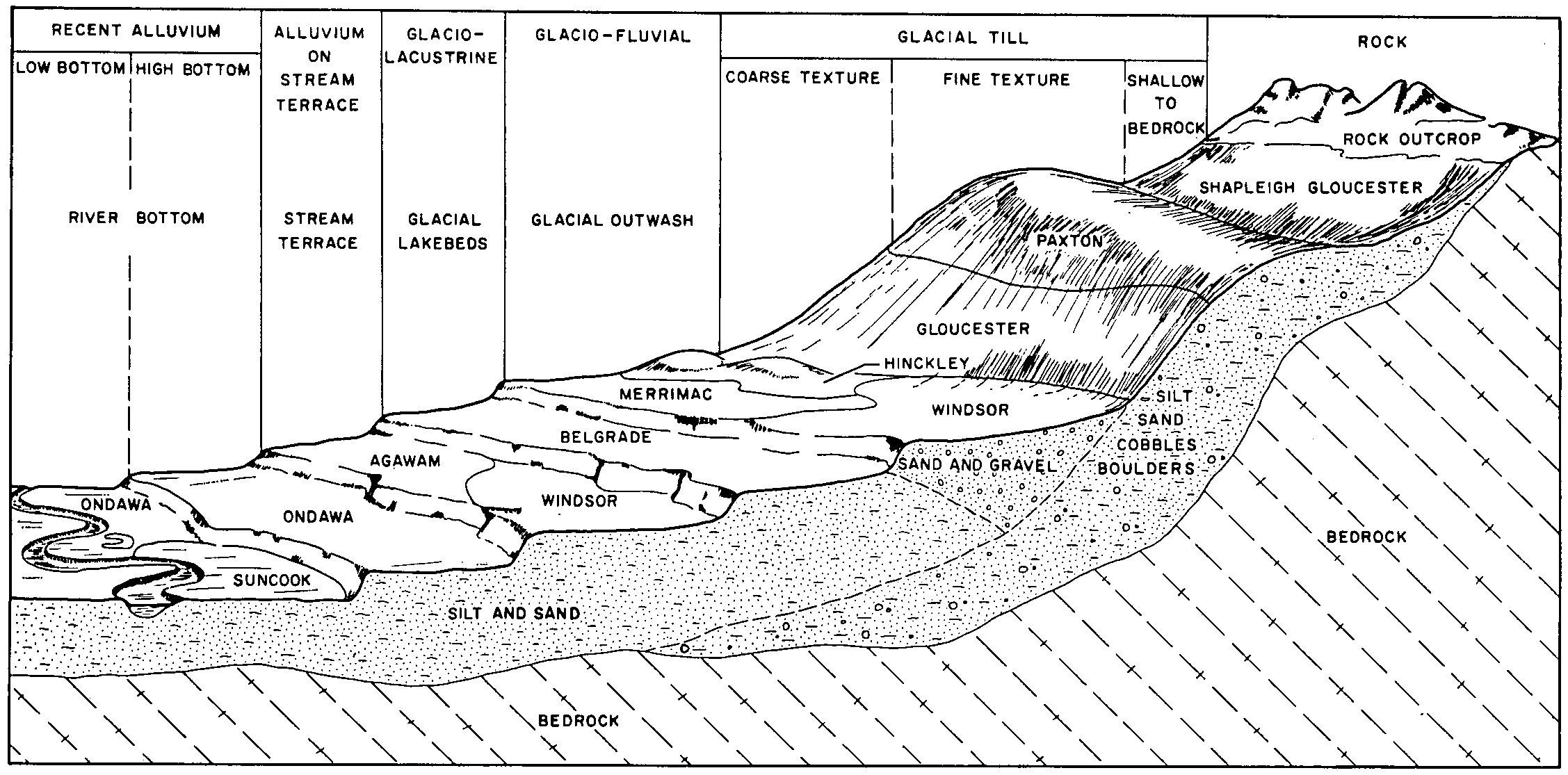
Gloucester extremely stony fine sandy loam, 8 to 25 percent slopes | GtD | 16782 | 279877 | 9d79 | nh017 | 1968 | 1:20000 |
Gloucester very stony fine sandy loam, 8 to 15 percent slopes | GsC | 16517 | 279874 | 9d76 | nh017 | 1968 | 1:20000 |
Gloucester very stony fine sandy loam, 3 to 8 percent slopes | GsB | 10414 | 279873 | 9d75 | nh017 | 1968 | 1:20000 |
Hollis-Gloucester extremely rocky fine sandy loams, 8 to 25 percent slopes | HlD | 6810 | 279897 | 9d7y | nh017 | 1968 | 1:20000 |
Hollis-Gloucester extremely rocky fine sandy loams, 25 to 60 percent slopes | HlE | 4726 | 279898 | 9d7z | nh017 | 1968 | 1:20000 |
Hollis-Gloucester very rocky fine sandy loams, 8 to 15 percent slopes | HgC | 4097 | 279895 | 9d7w | nh017 | 1968 | 1:20000 |
Gloucester very stony fine sandy loam, 15 to 25 percent slopes | GsD | 3135 | 279875 | 9d77 | nh017 | 1968 | 1:20000 |
Gloucester fine sandy loam, 3 to 8 percent slopes | GlB | 1898 | 279871 | 9d73 | nh017 | 1968 | 1:20000 |
Hollis-Gloucester very rocky fine sandy loams, 15 to 25 percent slopes | HgD | 1588 | 279896 | 9d7x | nh017 | 1968 | 1:20000 |
Hollis-Gloucester very rocky fine sandy loams, 3 to 8 percent slopes | HgB | 1513 | 279894 | 9d7v | nh017 | 1968 | 1:20000 |
Gloucester fine sandy loam, 8 to 15 percent slopes | GlC | 1013 | 279872 | 9d74 | nh017 | 1968 | 1:20000 |
Gloucester extremely stony fine sandy loam, 25 to 60 percent slopes | GtE | 994 | 279878 | 9d7b | nh017 | 1968 | 1:20000 |
Hollis-Gloucester fine sandy loams, 8 to 15 percent slopes | HfC | 475 | 279893 | 9d7t | nh017 | 1968 | 1:20000 |
Hollis-Gloucester fine sandy loams, 3 to 8 percent slopes | HfB | 454 | 279892 | 9d7s | nh017 | 1968 | 1:20000 |
Gloucester very stony fine sandy loam, 25 to 60 percent slopes | GsE | 432 | 279876 | 9d78 | nh017 | 1968 | 1:20000 |
Henniker-Gloucester fine sandy loams, cool, 8 to 15 percent slopes, very stony | 980C | 14058 | 1598363 | 1qn73 | nh603 | | 1:24000 |
Gloucester fine sandy loam, cool, 15 to 25 percent slopes, very stony | 245D | 5460 | 1600696 | 1qqnc | nh603 | | 1:24000 |
Gloucester fine sandy loam, cool, 8 to 25 percent slopes, extremely stony | 242D | 4816 | 1600715 | 1qqnz | nh603 | | 1:24000 |
Gloucester fine sandy loam, cool, 25 to 60 percent slopes, extremely stony | 242E | 1335 | 1600717 | 1qqp1 | nh603 | | 1:24000 |
Gloucester-Hinckley complex, 3 to 15 percent slopes, very stony | GhC | 7191 | 286237 | 2svlm | ri600 | 1977 | 1:12000 |
Gloucester-Hinckley complex, 15 to 35 percent slopes, very stony | GhD | 4412 | 286238 | 2svlp | ri600 | 1977 | 1:12000 |
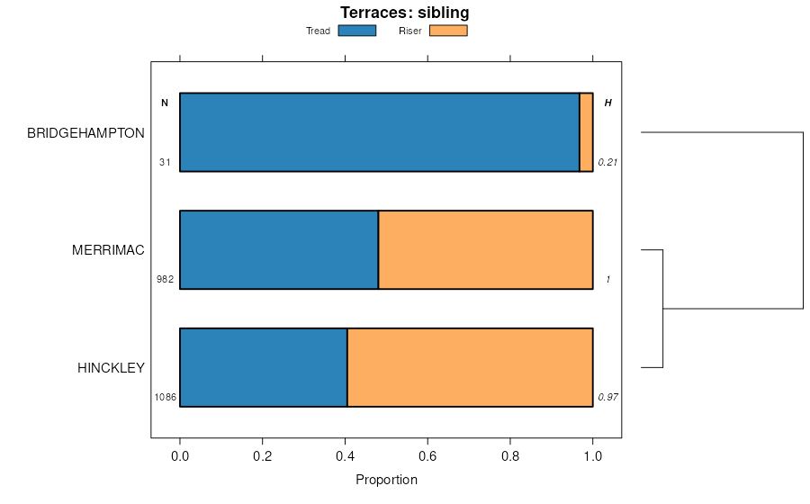
Gloucester-Bridgehampton complex, rolling | GBC | 849 | 286235 | 9lvd | ri600 | 1977 | 1:12000 |
Gloucester-Bridgehampton complex, hilly | GBD | 398 | 286236 | 9lvf | ri600 | 1977 | 1:12000 |