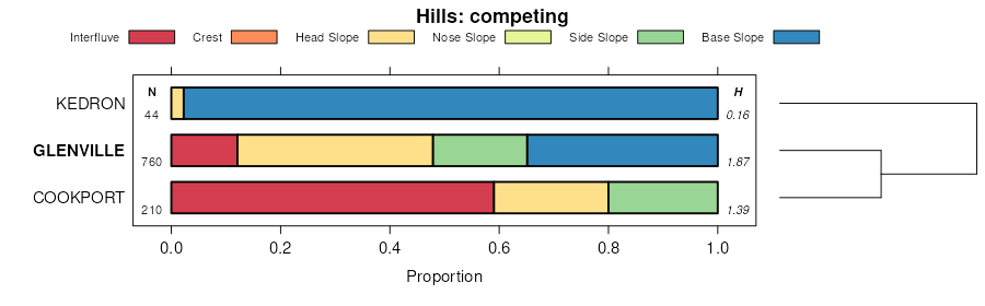
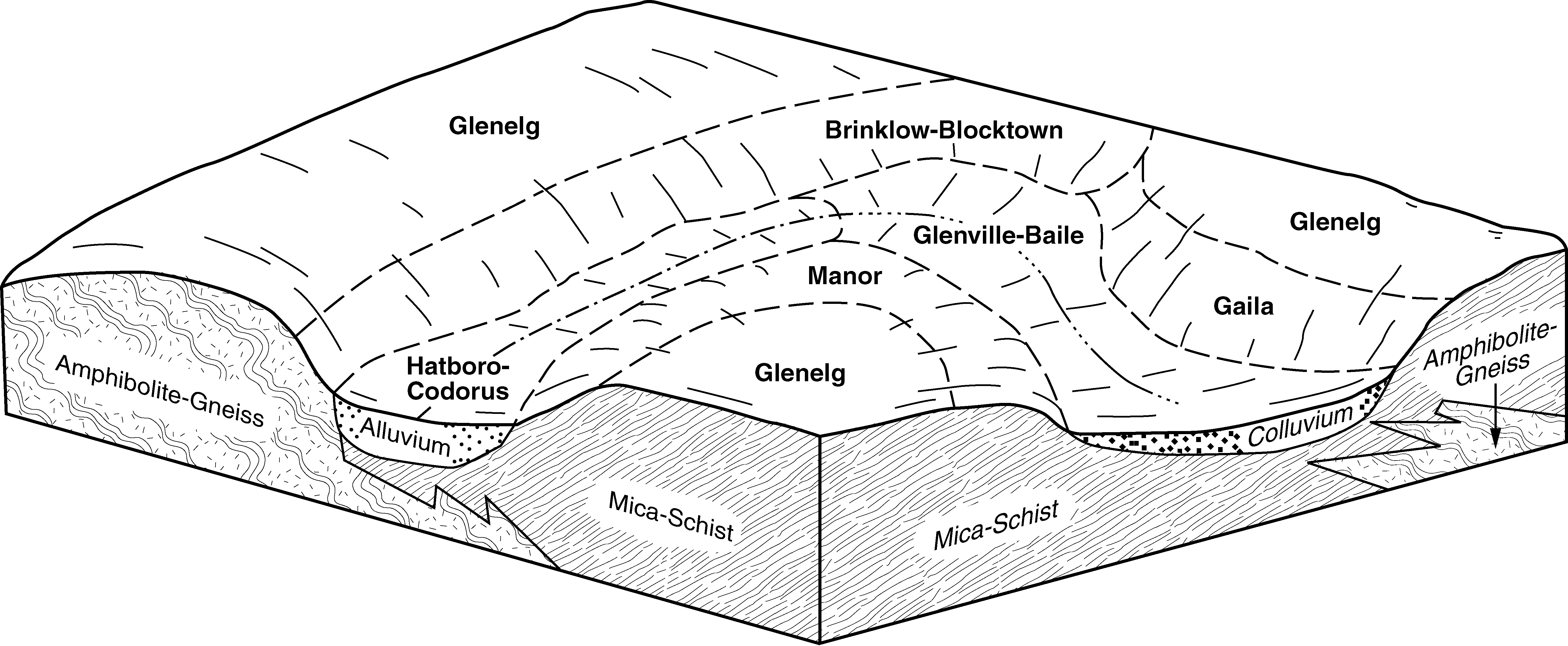
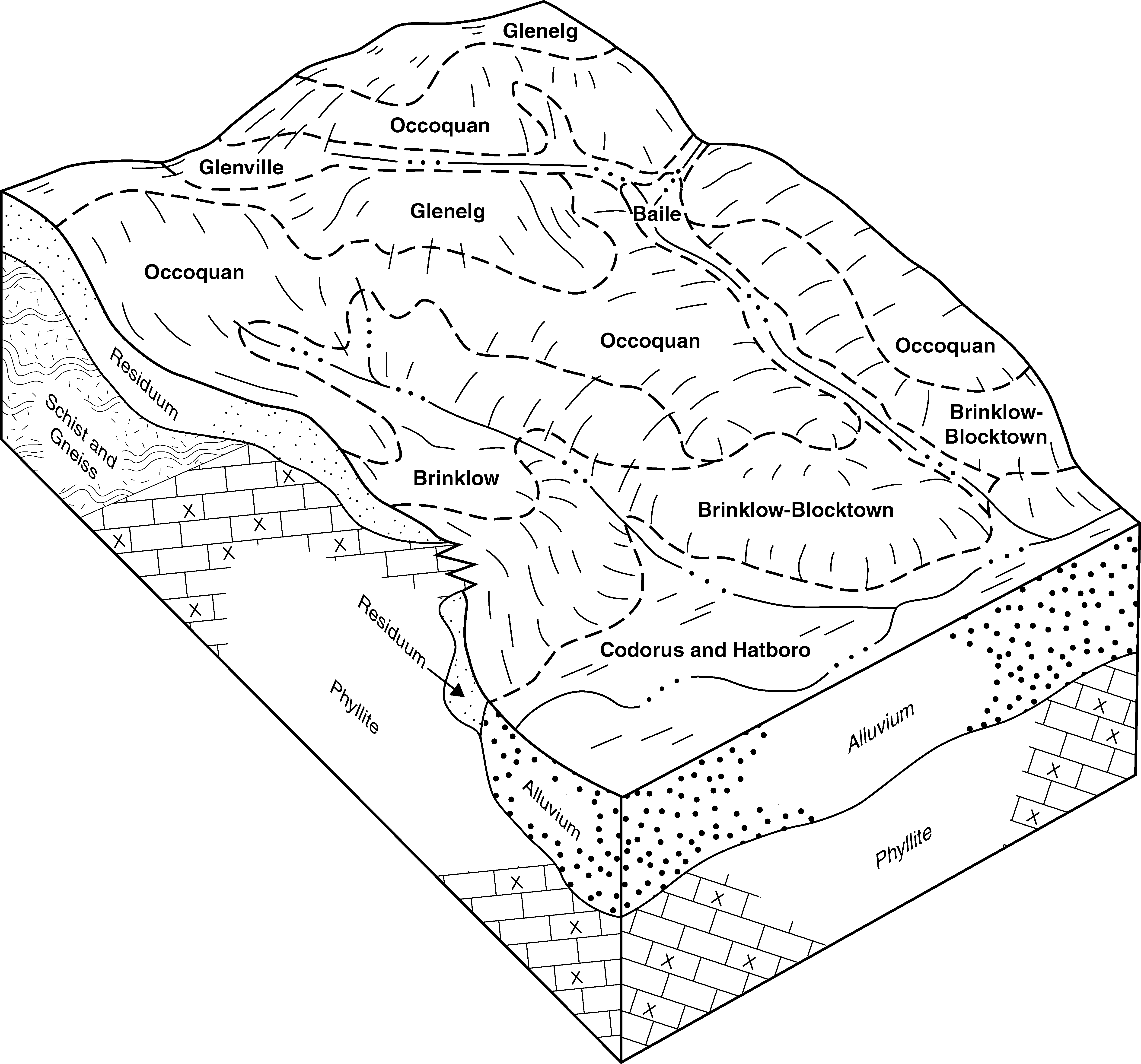
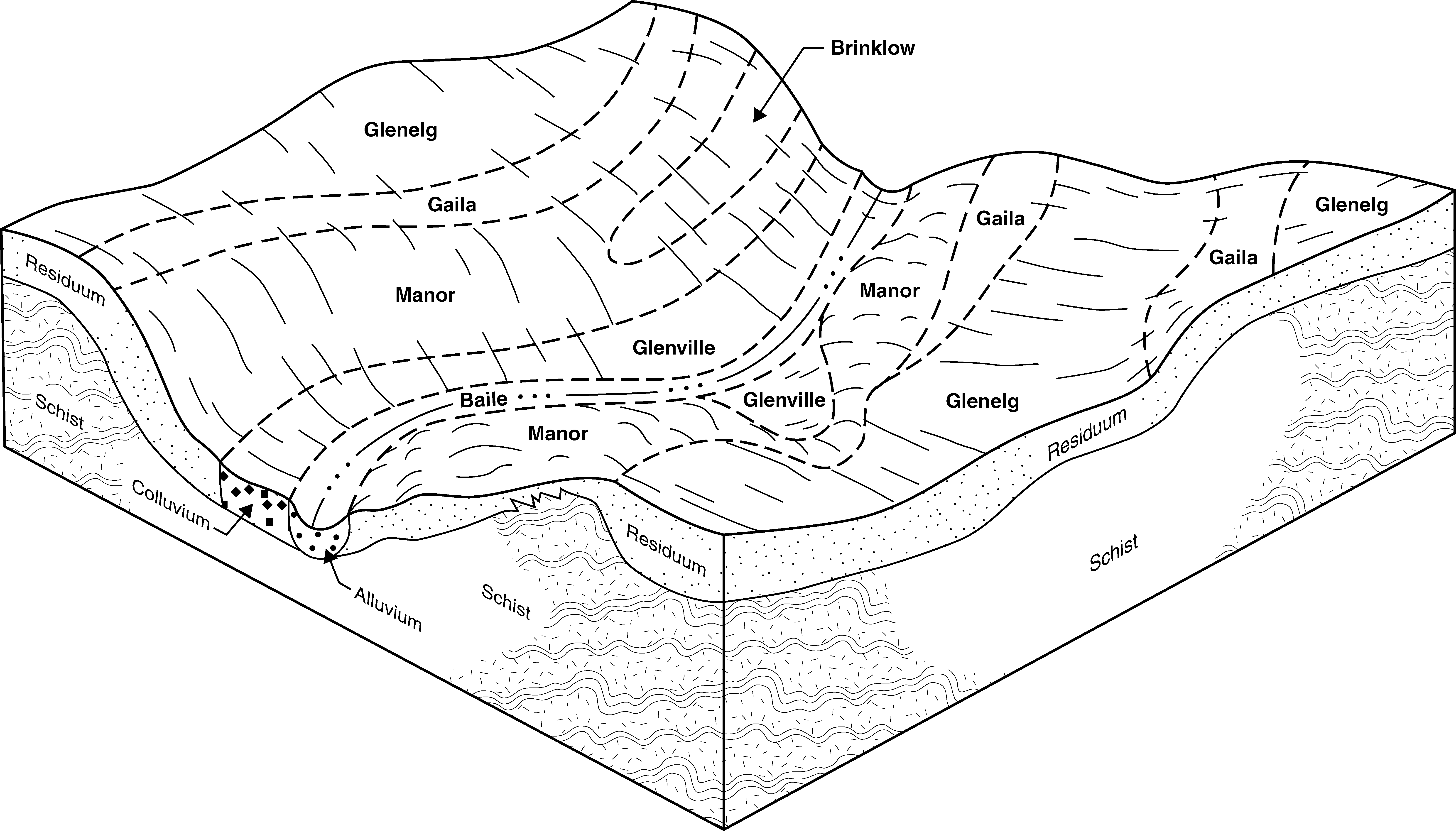
| Glenville silt loam, 3 to 8 percent slopes | GnB | 1933 | 2479867 | 2tmch | de003 | 2009 | 1:24000 |
Glenville silt loam, somewhat poorly drained, 0 to 3 percent slopes | GnA | 399 | 2479866 | 2w066 | de003 | 2009 | 1:24000 |
Glenville silt loam, somewhat poorly drained, 8 to 15 percent slopes | GnC | 258 | 2479868 | 2w067 | de003 | 2009 | 1:24000 |
Baile-Glenville complex, 0 to 8 percent slopes | BbB | 225 | 2479865 | 2p7hn | de003 | 2009 | 1:24000 |
Glenville silt loam, 3 to 8 percent slopes | GhB | 15960 | 2403681 | 2tmch | md005 | 2010 | 1:12000 |
Glenville silt loam, somewhat poorly drained, 8 to 15 percent slopes | GhC | 10202 | 2481199 | 2w067 | md005 | 2010 | 1:12000 |
Glenville silt loam, somewhat poorly drained, 0 to 3 percent slopes | GhA | 1478 | 2403680 | 2w066 | md005 | 2010 | 1:12000 |
Glenville-Urban land complex, 0 to 8 percent slopes | GkB | 1392 | 2403679 | 2lp71 | md005 | 2010 | 1:12000 |
Glenville silt loam, 3 to 8 percent slopes | GhB | 14244 | 2495833 | 2tmch | md013 | 2010 | 1:12000 |
Glenville silt loam, somewhat poorly drained, 8 to 15 percent slopes | GhC | 1688 | 2495834 | 2w067 | md013 | 2010 | 1:12000 |
Glenville-Urban land-Udorthents complex, 0 to 8 percent slopes | GkB | 605 | 2495835 | 2ptkc | md013 | 2010 | 1:12000 |
Glenville silt loam, somewhat poorly drained, 0 to 3 percent slopes | GhA | 351 | 2495832 | 2w066 | md013 | 2010 | 1:12000 |
Glenville silt loam, 3 to 8 percent slopes | GnB | 5749 | 2440720 | 2tmch | md015 | 2009 | 1:12000 |
Baile-Glenville complex, 3 to 8 percent slopes | BbB | 2448 | 2440717 | 2mxrt | md015 | 2009 | 1:12000 |
Glenville silt loam, somewhat poorly drained, 0 to 3 percent slopes | GnA | 768 | 2440719 | 2w066 | md015 | 2009 | 1:12000 |
Glenville silt loam, somewhat poorly drained, 8 to 15 percent slopes | GnC | 167 | 2440721 | 2w067 | md015 | 2009 | 1:12000 |
Glenville silt loam, 3 to 8 percent slopes | GoB | 3221 | 534976 | 2tmch | md021 | 2001 | 1:12000 |
Glenville-Baile silt loams, 3 to 8 percent slopes | GuB | 2908 | 534974 | kyp7 | md021 | 2001 | 1:12000 |
Baile-Glenville silt loams, 0 to 8 percent slopes | BcB | 1477 | 534906 | kym1 | md021 | 2001 | 1:12000 |
Glenville-Codorus complex, 3 to 8 percent slopes | GvB | 1131 | 559042 | lrqm | md021 | 2001 | 1:12000 |
Glenville silt loam, somewhat poorly drained, 8 to 15 percent slopes | GoC | 787 | 534975 | 2w067 | md021 | 2001 | 1:12000 |
Glenville-Codorus complex, 0 to 3 percent slopes | GvA | 293 | 534973 | kyp6 | md021 | 2001 | 1:12000 |
Glenville silt loam, 3 to 8 percent slopes | GmB | 7033 | 793000 | 2tmch | md027 | 2004 | 1:12000 |
Glenville-Baile silt loams, 0 to 8 percent slopes | GnB | 7011 | 793003 | vm5r | md027 | 2004 | 1:12000 |
Glenville silt loam, somewhat poorly drained, 8 to 15 percent slopes | GmC | 1103 | 793002 | 2w067 | md027 | 2004 | 1:12000 |
Glenville-Codorus silt loams, 0 to 8 percent slopes | GoB | 1086 | 793004 | vm5s | md027 | 2004 | 1:12000 |
Glenville-Urban land-Udorthents complex, 0 to 8 percent slopes | GuB | 950 | 793005 | vm5t | md027 | 2004 | 1:12000 |
Glenville silt loam, somewhat poorly drained, 0 to 3 percent slopes | GmA | 898 | 792999 | 2w066 | md027 | 2004 | 1:12000 |
Glenville silt loam, 3 to 8 percent slopes | 5B | 3905 | 533661 | 2tmch | md031 | 1989 | 1:15840 |
Glenville silt loam, somewhat poorly drained, 0 to 3 percent slopes | 5A | 1664 | 533660 | 2w066 | md031 | 1989 | 1:15840 |
Glenville silt loam, 3 to 8 percent slopes | GnB | 7588 | 533395 | 2tmch | md600 | 1972 | 1:15840 |
Glenville silt loam, somewhat poorly drained, 0 to 3 percent slopes | GnA | 1542 | 533394 | 2w066 | md600 | 1972 | 1:15840 |
Glenville silt loam, 3 to 8 percent slopes | GdB | 624 | 545589 | 2tmch | pa001 | 1991 | 1:24000 |
Glenville silt loam, somewhat poorly drained, 0 to 3 percent slopes | GdA | 126 | 545588 | 2w066 | pa001 | 1991 | 1:24000 |
Glenville silt loam, somewhat poorly drained, 0 to 3 percent slopes | GnA | 1566 | 543021 | 2w066 | pa011 | 1997 | 1:24000 |
Glenville silt loam, 3 to 8 percent slopes | GnB | 1365 | 543022 | 2tmch | pa011 | 1997 | 1:24000 |
Glenville silt loam, 3 to 8 percent slopes | GrB | 1287 | 543650 | 2tmch | pa017 | 1997 | 1:24000 |
Glenville silt loam, somewhat poorly drained, 0 to 3 percent slopes | GrA | 960 | 543649 | 2w066 | pa017 | 1997 | 1:24000 |
Urban land-Glenville complex, 0 to 8 percent slopes | UpB | 686 | 543740 | l7t0 | pa017 | 1997 | 1:24000 |
Glenville silt loam, 3 to 8 percent slopes | GlB | 9368 | 641523 | 2tmch | pa029 | 2008 | 1:24000 |
Glenville silt loam, somewhat poorly drained, 0 to 3 percent slopes | GlA | 1197 | 641522 | 2w066 | pa029 | 2008 | 1:24000 |
Urban land-Glenville complex, 0 to 8 percent slopes | UrnB | 230 | 1612247 | 1r3nz | pa029 | 2008 | 1:24000 |
Glenville silt loam, somewhat poorly drained, 8 to 15 percent slopes | GlC | 108 | 641525 | 2w067 | pa029 | 2008 | 1:24000 |
Glenville silt loam, 0 to 8 percent slopes, extremely stony | GxB | 24 | 641526 | pjkd | pa029 | 2008 | 1:24000 |
Glenville very stony silt loam, 0 to 8 percent slopes | GoB | 2887 | 693733 | r8wh | pa041 | 1980 | 1:15840 |
Glenville silt loam, 3 to 8 percent slopes | GnB | 1301 | 693732 | r8wg | pa041 | 1980 | 1:15840 |
Glenville silt loam, 3 to 8 percent slopes | GnB | 6322 | 984488 | 30cfc | pa045 | 2023 | 1:12000 |
Glenville silt loam, 0 to 8 percent slopes, very stony | GsB | 1078 | 984492 | 30cfg | pa045 | 2023 | 1:12000 |
Glenville silt loam, 0 to 3 percent slopes | GnA | 263 | 984487 | 30cfb | pa045 | 2023 | 1:12000 |
Glenville silt loam, 8 to 15 percent slopes | GnC | 117 | 984490 | 30cff | pa045 | 2023 | 1:12000 |
Glenville silt loam, 3 to 8 percent slopes | GdB | 17225 | 542754 | 2tmch | pa071 | 1982 | 1:15840 |
Glenville silt loam, 3 to 8 percent slopes | GnB | 1151 | 543152 | 2tmch | pa077 | 1997 | 1:24000 |
Glenville silt loam, somewhat poorly drained, 0 to 3 percent slopes | GnA | 121 | 543151 | 2w066 | pa077 | 1997 | 1:24000 |
Glenville silt loam, somewhat poorly drained, 8 to 15 percent slopes | GnC | 83 | 543153 | 2w067 | pa077 | 1997 | 1:24000 |
Glenville silt loam, 3 to 8 percent slopes | GsB | 660 | 2384072 | 2tmch | pa091 | 2008 | 1:12000 |
Glenville silt loam, somewhat poorly drained, 0 to 3 percent slopes | GsA | 108 | 541180 | 2w066 | pa091 | 2008 | 1:12000 |
Glenville silt loam, 3 to 8 percent slopes | GoB | 88 | 2396218 | 2tmch | pa101 | 1971 | 1:15840 |
Glenville silt loam, somewhat poorly drained, 0 to 3 percent slopes | GdA | 6093 | 542857 | 2w066 | pa133 | 1990 | 1:24000 |
Glenville silt loam, 3 to 8 percent slopes | GdB | 5459 | 542858 | 2tmch | pa133 | 1990 | 1:24000 |
Glenville loam, 0 to 4 percent slopes | 25A | 426 | 521168 | kh9w | va153 | 1985 | 1:15840 |


