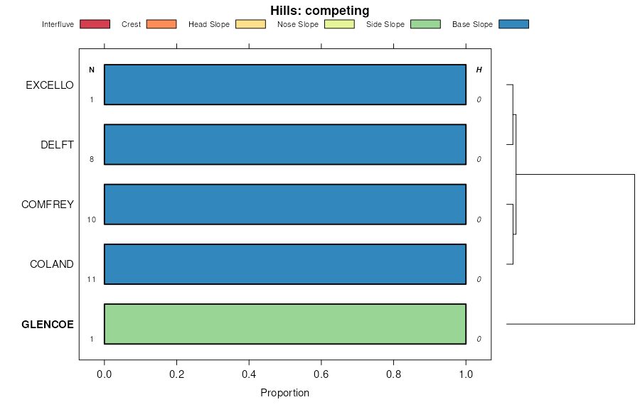
| Glencoe loam | Gc | 465 | 395923 | f8zq | mn003 | 1972 | 1:15840 |
Glencoe silty clay loam, 0 to 1 percent slopes | 114 | 6368 | 396134 | 2tsjs | mn013 | 1975 | 1:12000 |
Glencoe clay loam, 0 to 1 percent slopes | L84A | 5561 | 1674345 | 2tsjr | mn013 | 1975 | 1:12000 |
Glencoe-Dassel loams | 932 | 315 | 396222 | f99c | mn013 | 1975 | 1:12000 |
Glencoe clay loam, 0 to 1 percent slopes | L84A | 13748 | 1674347 | 2tsjr | mn015 | 1984 | 1:20000 |
Klossner, Okoboji and Glencoe soils, ponded, 0 to 1 percent slopes | 1052 | 2417 | 396252 | 2t3ny | mn015 | 1984 | 1:20000 |
Glencoe clay loam, 0 to 1 percent slopes | GL | 6627 | 396419 | 2tsjr | mn019 | 1987 | 1:12000 |
Glencoe clay loam, 0 to 1 percent slopes | L84A | 14006 | 1688308 | 2tsjr | mn033 | 2008 | 1:12000 |
Canisteo-Glencoe complex, 0 to 2 percent slopes | L107A | 3225 | 2421635 | 2vvf0 | mn033 | 2008 | 1:12000 |
Glencoe mucky silty clay loam, ponded, 0 to 1 percent slopes | L151A | 265 | 1857577 | 20byv | mn033 | 2008 | 1:12000 |
Glencoe silty clay loam, 0 to 1 percent slopes | 114 | 1856 | 396777 | 2tsjs | mn037 | 1980 | 1:15840 |
Canisteo-Glencoe complex, 0 to 2 percent slopes | L107A | 57405 | 1674439 | 2vvf0 | mn043 | 1989 | 1:20000 |
Klossner, Okoboji and Glencoe soils, ponded, 0 to 1 percent slopes | 1052 | 2806 | 397075 | 2t3ny | mn043 | 1989 | 1:20000 |
Glencoe clay loam, 0 to 1 percent slopes | L84A | 2542 | 1674348 | 2tsjr | mn043 | 1989 | 1:20000 |
Glencoe clay loam, 0 to 1 percent slopes | L84A | 27330 | 1674349 | 2tsjr | mn047 | 1977 | 1:15840 |
Glencoe clay loam, 0 to 1 percent slopes | L24A | 6986 | 451589 | 2tsjr | mn053 | 2001 | 1:12000 |
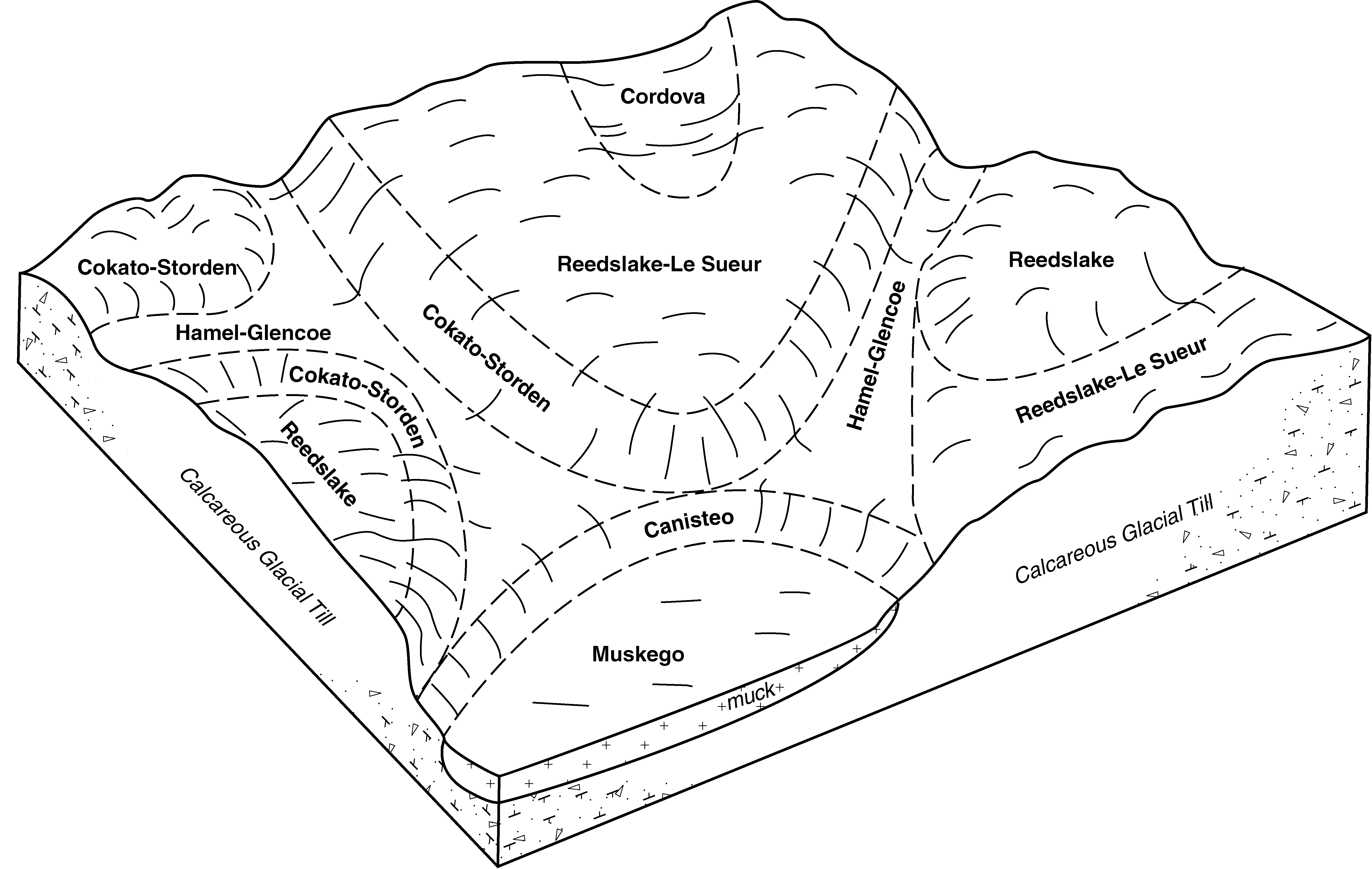
Hamel-Glencoe complex, 0 to 2 percent slopes | L132A | 3207 | 615947 | 2tsk3 | mn053 | 2001 | 1:12000 |
Klossner, Okoboji and Glencoe soils, ponded, 0 to 1 percent slopes | L15A | 468 | 451607 | 2t3ny | mn053 | 2001 | 1:12000 |
Canisteo-Glencoe complex, 0 to 2 percent slopes | L107A | 34113 | 1677510 | 2vvf0 | mn063 | 1984 | 1:20000 |
Glencoe clay loam, 0 to 1 percent slopes | L84A | 9071 | 1674346 | 2tsjr | mn063 | 1984 | 1:20000 |
Glencoe clay loam, ponded | 1051 | 6850 | 398488 | fcng | mn063 | 1984 | 1:20000 |
Harps-Glencoe-Seaforth complex, 0 to 3 percent slopes | 927 | 21797 | 398733 | 2t3p0 | mn067 | 1983 | 1:20000 |
Glencoe clay loam, 0 to 1 percent slopes | 114 | 181 | 398672 | 2tsjr | mn067 | 1983 | 1:20000 |
Harps-Glencoe-Seaforth complex, 0 to 3 percent slopes | 1108 | 49051 | 430215 | 2t3p0 | mn073 | 1994 | 1:20000 |
Glencoe clay loam, 0 to 1 percent slopes | L84A | 6742 | 1674338 | 2tsjr | mn073 | 1994 | 1:20000 |
Glencoe silty clay loam, ponded | 1051 | 3530 | 430210 | gfnr | mn073 | 1994 | 1:20000 |
Glencoe clay loam, 0 to 1 percent slopes | 114 | 13090 | 398928 | 2tsjr | mn079 | 1986 | 1:20000 |
Glencoe clay loam, 0 to 1 percent slopes | L84A | 19 | 1544675 | 2tsjr | mn081 | 2007 | 1:12000 |
Glencoe clay loam, 0 to 1 percent slopes | L84A | 12181 | 1859075 | 2tsjr | mn083 | 2008 | 1:12000 |
Glencoe silty clay loam, 0 to 1 percent slopes | 114 | 9 | 1859019 | 2tsjs | mn083 | 2008 | 1:12000 |
Canisteo-Glencoe complex, 0 to 2 percent slopes | L107A | 78961 | 1674437 | 2vvf0 | mn085 | 1993 | 1:20000 |
Harps-Glencoe complex | 1092 | 22785 | 399137 | fdbd | mn085 | 1993 | 1:20000 |
Glencoe clay loam, 0 to 1 percent slopes | L84A | 4197 | 1678850 | 2tsjr | mn085 | 1993 | 1:20000 |
Klossner, Okoboji and Glencoe soils, ponded, 0 to 1 percent slopes | 1080 | 3170 | 399133 | 2t3ny | mn085 | 1993 | 1:20000 |
Canisteo-Glencoe complex, 0 to 2 percent slopes | L107A | 137467 | 1674432 | 2vvf0 | mn091 | 1985 | 1:20000 |
Glencoe clay loam, 0 to 1 percent slopes | L84A | 12844 | 1674350 | 2tsjr | mn091 | 1985 | 1:20000 |
Klossner, Okoboji and Glencoe soils, ponded, 0 to 1 percent slopes | 1052 | 2870 | 400017 | 2t3ny | mn091 | 1985 | 1:20000 |
Hamel-Glencoe complex, 0 to 2 percent slopes | 740 | 9871 | 436417 | 2tsk3 | mn093 | 1996 | 1:20000 |
Canisteo-Glencoe complex, 0 to 2 percent slopes | L107A | 6412 | 1678852 | 2vvf0 | mn093 | 1996 | 1:20000 |
Klossner, Okoboji and Glencoe soils, ponded, 0 to 1 percent slopes | 1080 | 3172 | 436173 | 2t3ny | mn093 | 1996 | 1:20000 |
Glencoe clay loam, 0 to 1 percent slopes | L84A | 898 | 1674352 | 2tsjr | mn093 | 1996 | 1:20000 |
Glencoe silty clay loam, 0 to 1 percent slopes | 114 | 2643 | 1859420 | 2tsjs | mn101 | 2008 | 1:12000 |
Glencoe silty clay loam, ponded | 1051 | 2629 | 1859464 | 20dxq | mn101 | 2008 | 1:12000 |
Canisteo-Glencoe complex, 0 to 2 percent slopes | L107A | 28790 | 1676045 | 2vvf0 | mn103 | 1990 | 1:20000 |
Glencoe clay loam, 0 to 1 percent slopes | L84A | 10049 | 1674353 | 2tsjr | mn103 | 1990 | 1:20000 |
Glencoe silty clay loam, 0 to 1 percent slopes | 114 | 69 | 400573 | 2tsjs | mn103 | 1990 | 1:20000 |
Glencoe silty clay loam, 0 to 1 percent slopes | L146A | 5217 | 780765 | 2tsjs | mn105 | 2004 | 1:12000 |
Canisteo-Glencoe complex, 0 to 2 percent slopes | L107A | 1938 | 780781 | 2vvf0 | mn105 | 2004 | 1:12000 |
Glencoe mucky silty clay loam, ponded, 0 to 1 percent slopes | L151A | 422 | 785120 | vbzg | mn105 | 2004 | 1:12000 |
Glencoe clay loam, 0 to 1 percent slopes | L84A | 15025 | 2374072 | 2tsjr | mn127 | 2008 | 1:12000 |
Canisteo-Glencoe complex, 0 to 2 percent slopes | L107A | 80693 | 1678859 | 2vvf0 | mn129 | 1995 | 1:20000 |
Harps-Glencoe-Seaforth complex, 0 to 3 percent slopes | 927 | 9206 | 436136 | 2t3p0 | mn129 | 1995 | 1:20000 |
Klossner, Okoboji and Glencoe soils, ponded, 0 to 1 percent slopes | 1080 | 2634 | 435994 | 2t3ny | mn129 | 1995 | 1:20000 |
Glencoe clay loam, 0 to 1 percent slopes | 114 | 7651 | 429544 | 2tsjr | mn131 | 1996 | 1:12000 |
Klossner, Okoboji and Glencoe soils, ponded, 0 to 1 percent slopes | 1080 | 5351 | 429539 | 2t3ny | mn131 | 1996 | 1:12000 |
Webster-Glencoe silty clay loams | Wb | 17991 | 428058 | gcfb | mn139 | 1988 | 1:20000 |
Glencoe silty clay loam, 0 to 1 percent slopes | Ga | 7957 | 427972 | 2tsjs | mn139 | 1988 | 1:20000 |
Canisteo-Glencoe complex, 0 to 2 percent slopes | L107A | 65784 | 1676064 | 2vvf0 | mn143 | 1991 | 1:20000 |
Glencoe clay loam, 0 to 1 percent slopes | L84A | 5040 | 1674354 | 2tsjr | mn143 | 1991 | 1:20000 |
Glencoe clay loam, stratified substratum | 743 | 809 | 431538 | gh1l | mn143 | 1991 | 1:20000 |
Glencoe muck | 1828 | 1499 | 428093 | gcgg | mn145 | 1980 | 1:15840 |
Glencoe clay loam, 0 to 1 percent slopes | Gc | 18174 | 428234 | 2tsjr | mn147 | 1967 | 1:20000 |
Canisteo-Glencoe complex, 0 to 2 percent slopes | L107A | 28707 | 455462 | 2vvf0 | mn161 | 2001 | 1:12000 |
Glencoe clay loam, 0 to 1 percent slopes | L84A | 7624 | 455433 | 2tsjr | mn161 | 2001 | 1:12000 |
Klossner, Okoboji and Glencoe soils, ponded, 0 to 1 percent slopes | L15A | 1524 | 455466 | 2t3ny | mn161 | 2001 | 1:12000 |
Glencoe mucky clay loam, depressional, 0 to 1 percent slopes | L124A | 343 | 455484 | h8z1 | mn161 | 2001 | 1:12000 |
Canisteo-Glencoe complex, 0 to 2 percent slopes | L107A | 12969 | 1678856 | 2vvf0 | mn165 | 1987 | 1:20000 |
Glencoe clay loam, 0 to 1 percent slopes | L84A | 9765 | 1674355 | 2tsjr | mn165 | 1987 | 1:20000 |
Klossner, Okoboji and Glencoe soils, ponded, 0 to 1 percent slopes | 1055 | 2345 | 428910 | 2t3ny | mn165 | 1987 | 1:20000 |
Glencoe clay loam, 0 to 1 percent slopes | 114 | 11029 | 433689 | 2tsjr | mn171 | 1998 | 1:12000 |
Hamel-Glencoe complex, 0 to 2 percent slopes | 740 | 7201 | 433807 | 2tsk3 | mn171 | 1998 | 1:12000 |
Canisteo-Glencoe complex, 0 to 2 percent slopes | 956 | 7072 | 435012 | 2vvf0 | mn171 | 1998 | 1:12000 |
Klossner, Okoboji and Glencoe soils, ponded, 0 to 1 percent slopes | 1080 | 5930 | 435031 | 2t3ny | mn171 | 1998 | 1:12000 |
Glencoe clay loam, 0 to 1 percent slopes | L84A | 9321 | 1674339 | 2tsjr | mn173 | 1979 | 1:20000 |