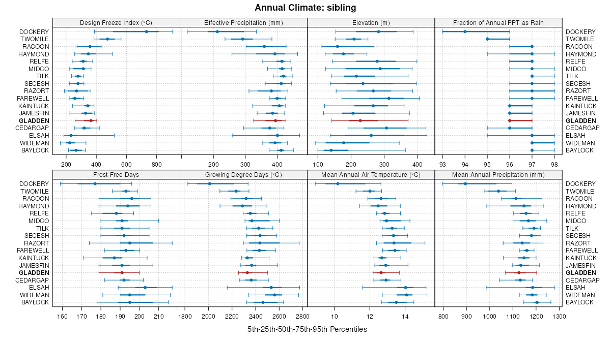
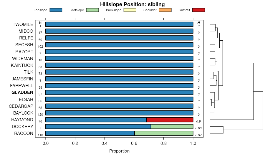
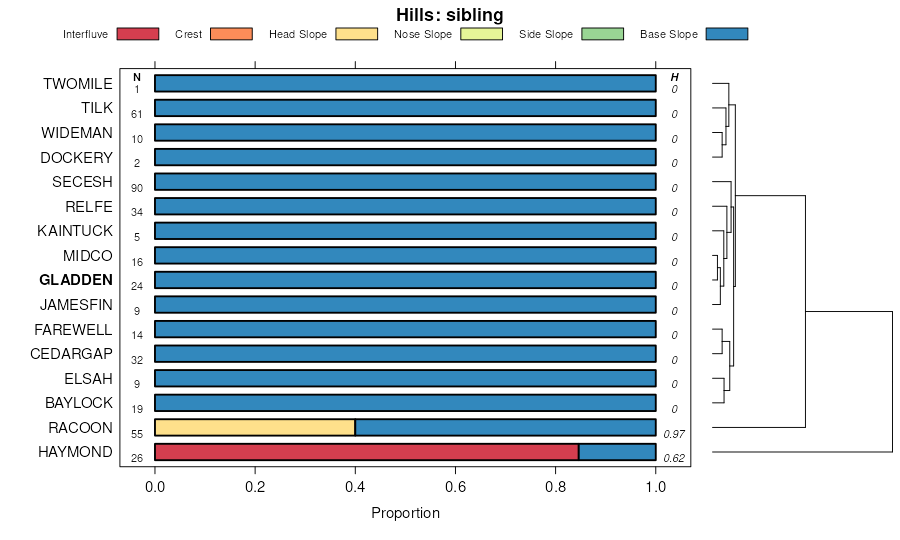
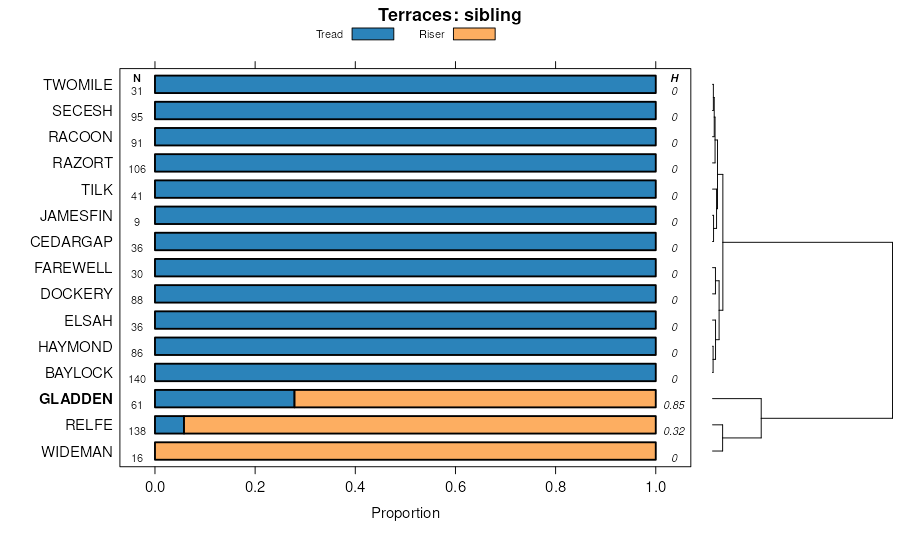
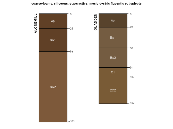
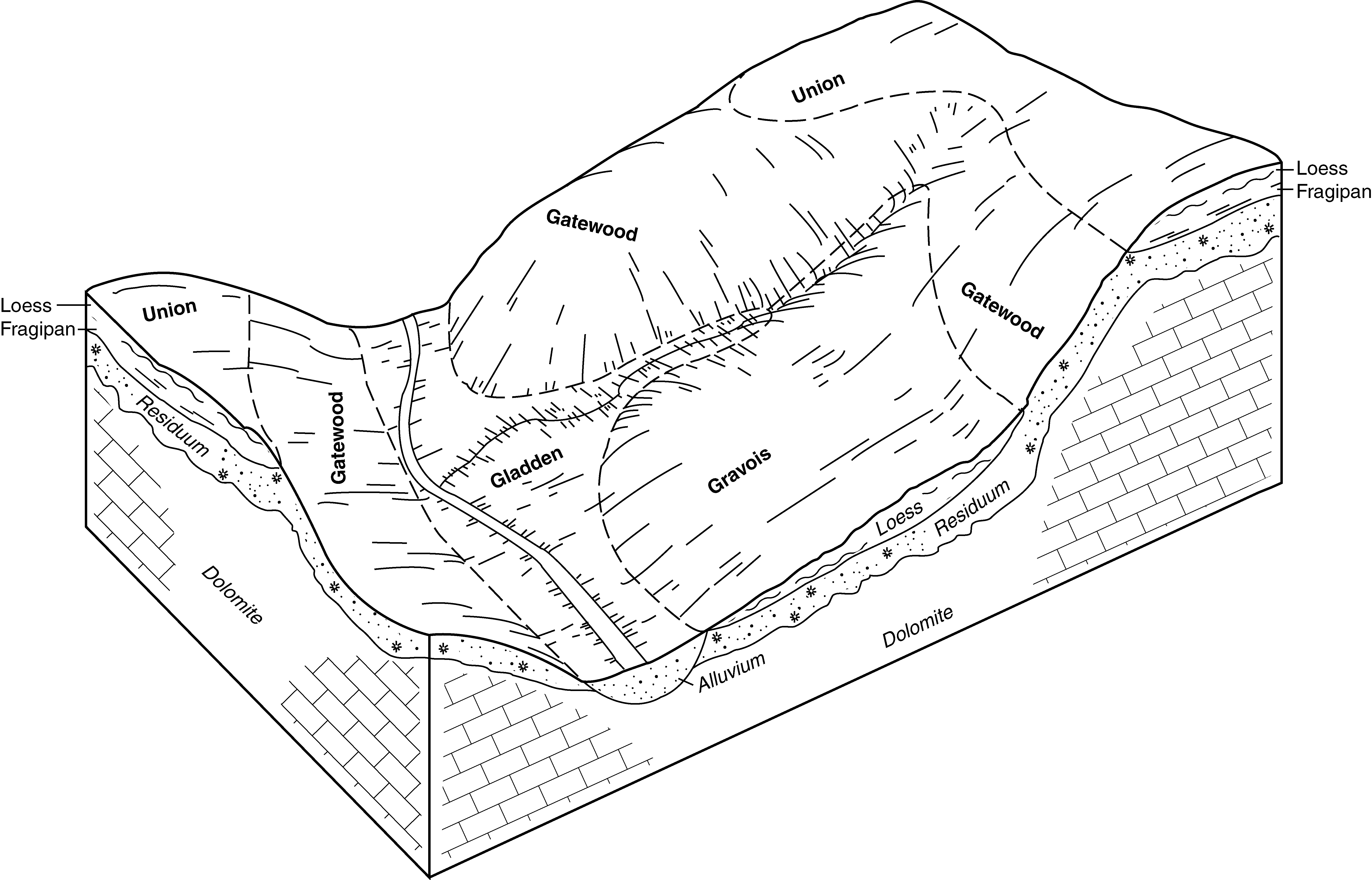
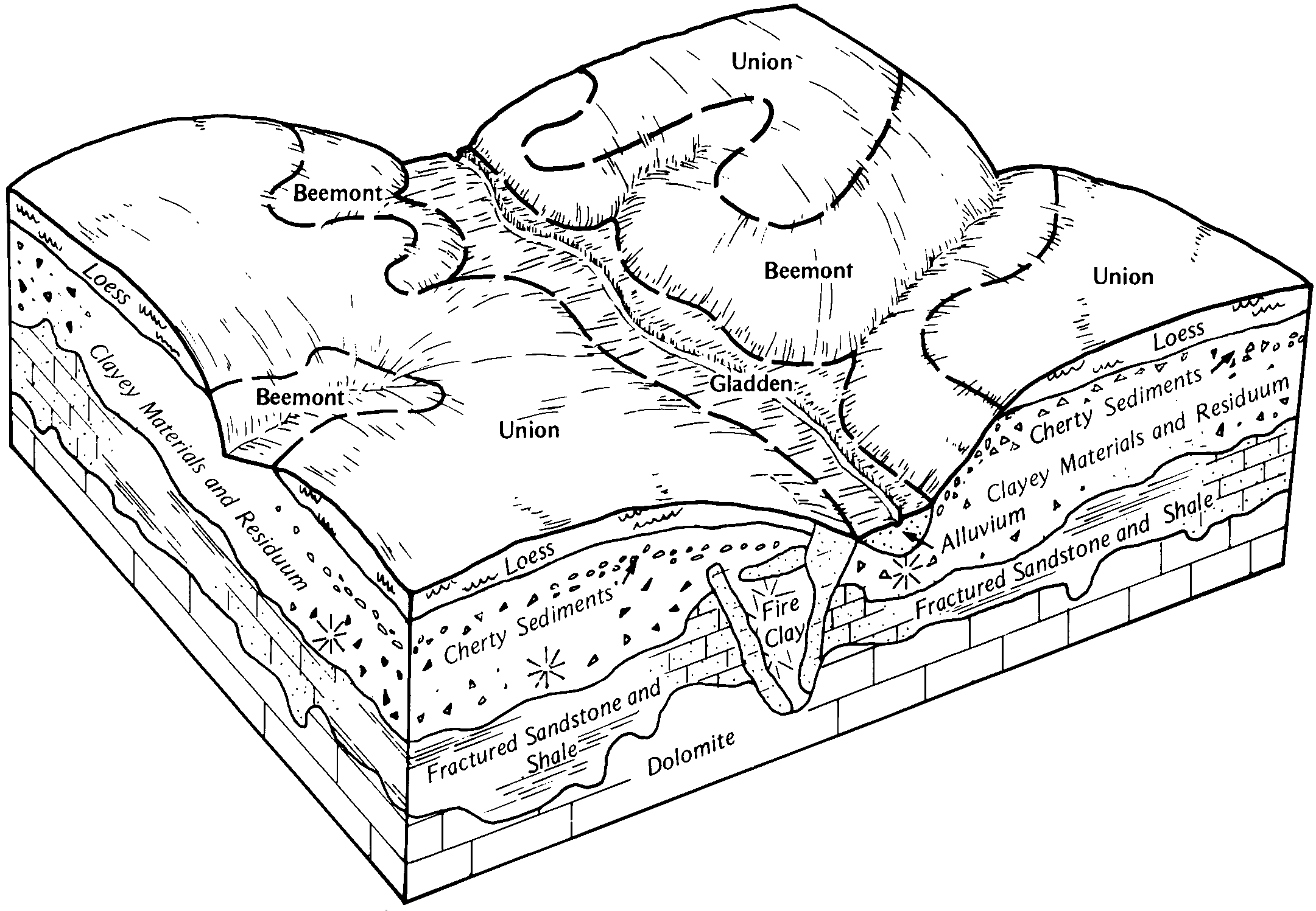
| Gladden silt loam, 0 to 3 percent slopes, occasionally flooded | 75451 | 568 | 2502847 | 2vxvn | mo017 | 2004 | 1:24000 |
Gladden loam, 0 to 3 percent slopes, occasionally flooded | 75416 | 481 | 2502782 | 2vxv9 | mo017 | 2004 | 1:24000 |
Gladden silt loam, 1 to 3 percent slopes, occasionally flooded | 76017 | 87 | 2503351 | 2t7hk | mo017 | 2004 | 1:24000 |
Gladden fine sandy loam, 0 to 3 percent slopes, frequently flooded | 75452 | 427 | 2502860 | 2q29h | mo023 | 1982 | 1:24000 |
Gladden silt loam, 0 to 3 percent slopes, occasionally flooded | 75451 | 19 | 2502852 | 2vxvn | mo023 | 1982 | 1:24000 |
Gladden loam, 0 to 3 percent slopes, occasionally flooded | 75416 | 46 | 2502788 | 2vxv9 | mo031 | 1978 | 1:24000 |
Gladden silt loam, 0 to 3 percent slopes, occasionally flooded | 75451 | 4 | 2502853 | 2vxvn | mo031 | 1978 | 1:24000 |
Gladden silt loam, 0 to 3 percent slopes, occasionally flooded | 75451 | 426 | 2502854 | 2vxvn | mo035 | 1988 | 1:24000 |
Gladden loam, 1 to 3 percent slopes, occasionally flooded | 76016 | 2794 | 2503345 | 2t7hg | mo065 | 1971 | 1:24000 |
Gladden loam, 0 to 3 percent slopes, occasionally flooded | 75416 | 2275 | 2502783 | 2vxv9 | mo065 | 1971 | 1:24000 |
Gladden silt loam, 0 to 3 percent slopes, occasionally flooded | 75451 | 3 | 2502848 | 2vxvn | mo065 | 1971 | 1:24000 |
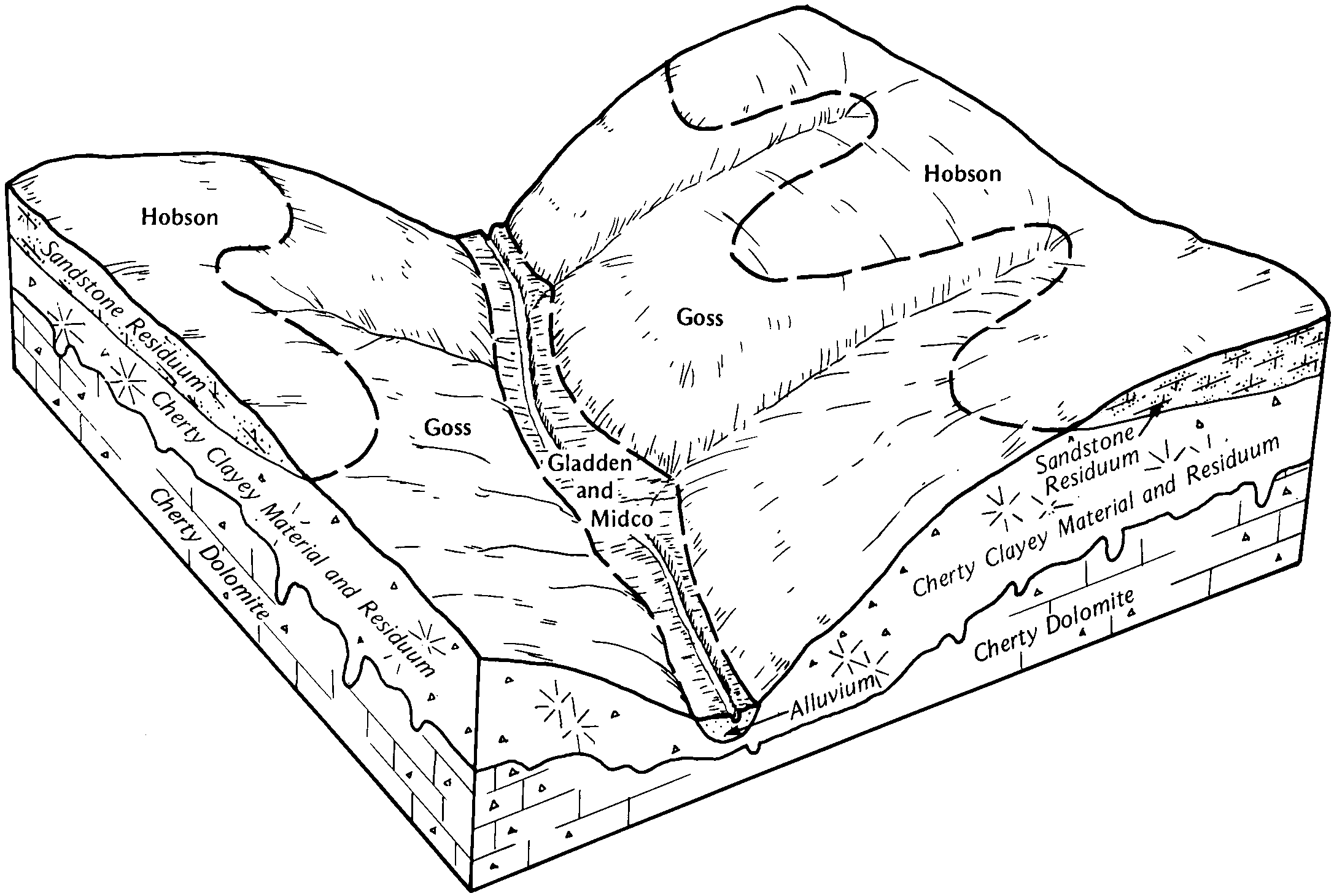
Gladden-Midco complex, 0 to 3 percent slopes, frequently flooded | 75489 | 8062 | 572298 | 2t7f4 | mo071 | 1986 | 1:24000 |
Gladden-Midco complex, 1 to 3 percent slopes, frequently flooded | 67140 | 5172 | 2575506 | 2zcdh | mo071 | 1986 | 1:24000 |
Gladden silt loam, 1 to 3 percent slopes, frequently flooded | 76400 | 3857 | 2688274 | 2rt14 | mo071 | 1986 | 1:24000 |
Gladden silt loam, 0 to 2 percent slopes, frequently flooded | 75400 | 3085 | 2536580 | 2qq0n | mo071 | 1986 | 1:24000 |
Gladden fine sandy loam, 0 to 3 percent slopes, frequently flooded | 75452 | 26 | 2502857 | 2q29h | mo071 | 1986 | 1:24000 |
Gladden silt loam, 0 to 2 percent slopes, frequently flooded | 75400 | 11985 | 2536581 | 2qq0n | mo073 | 1992 | 1:24000 |
Gladden silt loam, 1 to 3 percent slopes, frequently flooded | 76400 | 6363 | 2688266 | 2rt14 | mo073 | 1992 | 1:24000 |
Gladden silt loam, 0 to 3 percent slopes, occasionally flooded | 75451 | 3 | 2502849 | 2vxvn | mo093 | 1988 | 1:24000 |
Gladden fine sandy loam, 0 to 3 percent slopes, frequently flooded | 75452 | 3185 | 2502858 | 2q29h | mo099 | 2000 | 1:24000 |
Gladden fine sandy loam, 1 to 3 percent slopes, frequently flooded | 67130 | 1187 | 2575508 | 2tbrf | mo099 | 2000 | 1:24000 |
Cedargap, frequently flooded-Gladden, occasionally flooded complex, 0 to 2 percent slopes | 76755 | 9204 | 2673131 | 2rt0x | mo119 | 2004 | 1:24000 |
Cedargap, frequently flooded-Gladden, occasionally flooded complex, 1 to 3 percent slopes | 71755 | 410 | 808604 | w4f0 | mo119 | 2004 | 1:24000 |
Gladden loam, 0 to 3 percent slopes, occasionally flooded | 75416 | 2089 | 2502784 | 2vxv9 | mo123 | 1999 | 1:24000 |
Gladden loam, 1 to 3 percent slopes, occasionally flooded | 76016 | 259 | 2503346 | 2t7hg | mo123 | 1999 | 1:24000 |
Gladden silt loam, 0 to 2 percent slopes, frequently flooded | 75400 | 7029 | 2536582 | 2qq0n | mo125 | 2001 | 1:24000 |
Gladden silt loam, 1 to 3 percent slopes, frequently flooded | 76400 | 3662 | 2673127 | 2rt14 | mo125 | 2001 | 1:24000 |
Gladden silt loam, 0 to 2 percent slopes, frequently flooded | 75400 | 6 | 2536583 | 2qq0n | mo131 | 2001 | 1:24000 |
Gladden silt loam, 0 to 2 percent slopes, frequently flooded | 75400 | 10190 | 2536579 | 2qq0n | mo151 | 1996 | 1:24000 |
Gladden silt loam, 1 to 3 percent slopes, frequently flooded | 76400 | 5653 | 2688264 | 2rt14 | mo151 | 1996 | 1:24000 |
Gladden fine sandy loam, 0 to 3 percent slopes, frequently flooded | 75452 | 768 | 2502859 | 2q29h | mo157 | 1983 | 1:24000 |
Gladden fine sandy loam, 1 to 3 percent slopes, frequently flooded | 76052 | 259 | 909625 | 2tbrf | mo157 | 1983 | 1:24000 |
Gladden loam, 0 to 3 percent slopes, occasionally flooded | 75416 | 958 | 2502785 | 2vxv9 | mo179 | 2004 | 1:24000 |
Gladden silt loam, 0 to 3 percent slopes, occasionally flooded | 75451 | 109 | 2502850 | 2vxvn | mo179 | 2004 | 1:24000 |
Gladden silt loam, 1 to 3 percent slopes, occasionally flooded | 76017 | 47 | 2503354 | 2t7hk | mo179 | 2004 | 1:24000 |
Gladden loam, 0 to 3 percent slopes, occasionally flooded | 75416 | 97 | 2502786 | 2vxv9 | mo187 | 1979 | 1:24000 |
Gladden loam, 1 to 3 percent slopes, occasionally flooded | 76016 | 50 | 2503348 | 2t7hg | mo187 | 1979 | 1:24000 |
Gladden fine sandy loam, 0 to 3 percent slopes, frequently flooded | 75452 | 4 | 2502856 | 2q29h | mo189 | 1979 | 1:24000 |
Gladden silt loam, 0 to 3 percent slopes, occasionally flooded | 75451 | 549 | 2502855 | 2vxvn | mo203 | 2004 | 1:24000 |
Gladden loam, 0 to 3 percent slopes, occasionally flooded | 75416 | 450 | 2502789 | 2vxv9 | mo203 | 2004 | 1:24000 |
Gladden silt loam, 1 to 3 percent slopes, occasionally flooded | 76017 | 108 | 2503358 | 2t7hk | mo203 | 2004 | 1:24000 |
Gladden silt loam, 0 to 3 percent slopes, occasionally flooded | 75451 | 3895 | 2502851 | 2vxvn | mo223 | 2004 | 1:24000 |
Gladden loam, 0 to 3 percent slopes, occasionally flooded | 75416 | 780 | 2502787 | 2vxv9 | mo223 | 2004 | 1:24000 |
Gladden silt loam, 1 to 3 percent slopes, occasionally flooded | 76017 | 11 | 2487788 | 2t7hk | mo223 | 2004 | 1:24000 |
