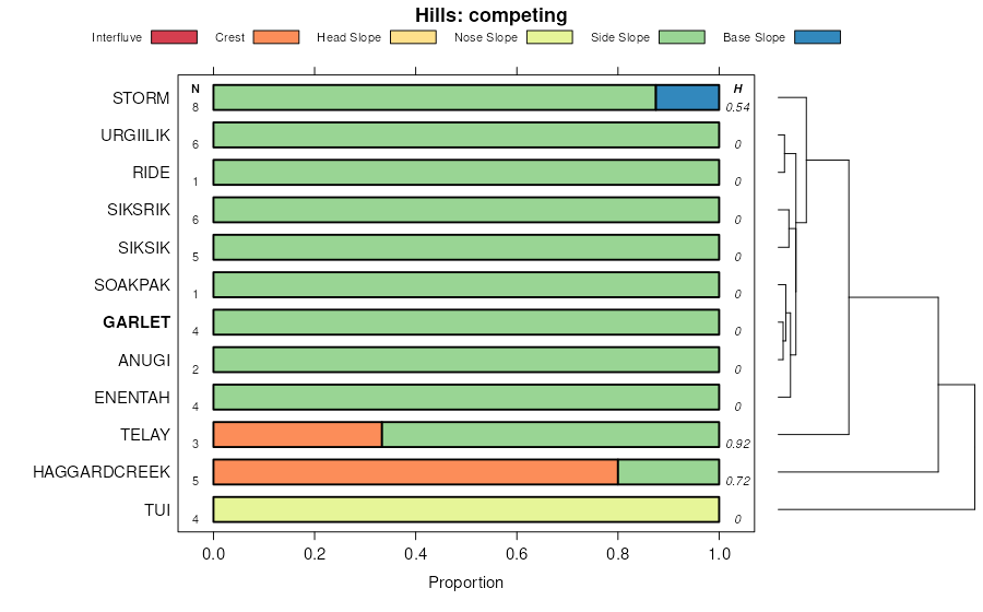
| Stecum-Garlet families association, 5 to 30 percent slopes. | 365 | 3652 | 471478 | htlz | ca732 | 1998 | 1:24000 |
Garlet-Cowood families-Rock outcrop association, 15 to 60 percent slopes. | 363 | 3588 | 471476 | htlx | ca732 | 1998 | 1:24000 |
Garlet-Stecum families complex, 2 to 15 percent slopes. | 387 | 910 | 471500 | htmp | ca732 | 1998 | 1:24000 |
Garlet-Stecum families complex, 2 to 15 percent slopes. | 387iw | 237 | 2230042 | 2dvjv | ca740 | 1996 | 1:24000 |
Garlet-Dromedary-Woodhurst families, complex, 30 to 70 percent slopes | 246 | 138 | 2984238 | 534g | id713 | | 1:24000 |
Rubble land-Garlet family, very stony surface-Typic Calcicryepts family, extremely stony surface, complex, 35 to 70 percent slopes | 43B7DX | 2423 | 3458641 | 31wm3 | id720 | | 1:24000 |
Calcic Argicryolls family, stony surface-Hailman family-Garlet family, very stony surface, complex, 5 to 70 percent slopes | 43B7DY | 1267 | 3458651 | 31wmf | id720 | | 1:24000 |
Garlet-Comad families, complex, mountain ridgetops | 103B | 988 | 2024031 | 25y5b | id758 | 1998 | 1:24000 |
Garlet family-Rock outcrop-Como family, complex, steep mountain slopes | 542Vr | 774 | 2024065 | 25y6f | id758 | 1998 | 1:24000 |
Garlet family-Rock outcrop-Tenrag family, complex, cirque headwalls | 213Vr | 409 | 2024036 | 25y5h | id758 | 1998 | 1:24000 |
Como-Garlet-Lowder families, complex, glacial moraines | 341S | 352 | 2024042 | 25y5p | id758 | 1998 | 1:24000 |
Como-Garlet-Elkner families, complex, steep mountain slopes | 541S | 53 | 2024064 | 25y6d | id758 | 1998 | 1:24000 |
Garlet-Relyea-Yellowmule families, complex, gentle mountain slopes | 524V | 21 | 2024045 | 25y5s | id758 | 1998 | 1:24000 |
Como-Garlet families-Rock outcrop complex, steep mountain slopes | 541Sr | 3 | 2024128 | 25y8g | id758 | 1998 | 1:24000 |
Garlet-Elkner complex, 25 to 70 percent slopes | 182F | 6577 | 343863 | cjtc | mt041 | 1994 | 1:24000 |
Garlet stony loam, very steep | GL | 3779 | 146823 | 4xs7 | mt600 | 1969 | 1:24000 |
Storm, very stony-Lonniebee, stony-Garlet families, complex, 15 to 60 percent slopes | 6370F | 95 | 3169265 | 2v2sh | mt600 | 1969 | 1:24000 |
Swifton-Garlet association, hilly | SX | 89 | 146926 | 4xwk | mt600 | 1969 | 1:24000 |
Garlet-Worock-Como families, complex, moderately steep mountain slopes | 537S | 39646 | 148668 | 4zpr | mt605 | 2007 | 1:24000 |
Como-Comad-Garlet families, complex, moderately steep mountain slopes | 538S | 38200 | 148674 | 4zpy | mt605 | 2007 | 1:24000 |
Garlet-Worock-Como families, complex, gentle mountain slopes | 527S | 32422 | 148624 | 4znb | mt605 | 2007 | 1:24000 |
Petty-Garlet families, complex, valley trough walls | 227Sa | 31064 | 636478 | pc9k | mt605 | 2007 | 1:24000 |
Garlet-Holloway-Bata families, complex, moderately steep mountain slopes | 537Sa | 25628 | 149361 | 50f3 | mt605 | 2007 | 1:24000 |
Adel-Garlet-Yellowmule families, complex, landslide deposits | 704T | 24586 | 148765 | 4zsw | mt605 | 2007 | 1:24000 |
Garlet-Como families-Rock outcrop complex, steep mountain slopes | 547Sr | 20852 | 149127 | 505k | mt605 | 2007 | 1:24000 |
Garlet-Como-Worock families, complex, steep mountain slopes | 547S | 16763 | 148715 | 4zr8 | mt605 | 2007 | 1:24000 |
Garlet-Worock-Como families, complex, glacial moraines | 347S | 16567 | 149346 | 50dm | mt605 | 2007 | 1:24000 |
Garlet-Como-Worock families, complex, cirque basins | 258S | 14856 | 148570 | 4zll | mt605 | 2007 | 1:24000 |
Como-Garlet families, complex, moderately steep mountain slopes | 531S | 14290 | 148634 | 4znn | mt605 | 2007 | 1:24000 |
Yellowmule-Garlet-Swifton families, complex, landslide deposits | 704S | 13275 | 148764 | 4zsv | mt605 | 2007 | 1:24000 |
Bata-Holloway-Garlet families, complex, gentle mountain slopes | 527Sa | 13227 | 149093 | 504g | mt605 | 2007 | 1:24000 |
Garlet-Worock families-Rock outcrop complex, valley trough walls | 227Sr | 12235 | 149341 | 50dg | mt605 | 2007 | 1:24000 |
Elkner-Tenrag-Garlet families, complex, gentle mountain slopes | 522S | 11276 | 148604 | 4zmp | mt605 | 2007 | 1:24000 |
Garlet-Yellowmule-Tenrag families, complex, moderately steep mountain slopes | 534S | 10589 | 148651 | 4zp6 | mt605 | 2007 | 1:24000 |
Como-Garlet-Elkner families, complex, steep mountain slopes | 541S | 10428 | 148679 | 4zq3 | mt605 | 2007 | 1:24000 |
Petty-Garlet families-Rubble land complex, valley trough walls | 227Sra | 9783 | 149365 | 50f7 | mt605 | 2007 | 1:24000 |
Garlet-Moran families, complex, mountain ridgetops | 107S | 8194 | 149106 | 504w | mt605 | 2007 | 1:24000 |
Garlet-Como-Matcher families, complex, valley trough walls | 221S | 7899 | 149179 | 5077 | mt605 | 2007 | 1:24000 |
Garlet-Holloway families, complex, steep mountain slopes | 547Sa | 5521 | 633827 | p8k1 | mt605 | 2007 | 1:24000 |
Garlet-Swifton-Tenrag families, complex, gentle mountain slopes | 524S | 5408 | 148610 | 4zmw | mt605 | 2007 | 1:24000 |
Garlet-Tibson families, complex, glacial moraines | 344T | 5096 | 148581 | 4zly | mt605 | 2007 | 1:24000 |
Garlet-Como families-Rock outcrop complex, valley trough walls | 221Sr | 5089 | 148545 | 4zks | mt605 | 2007 | 1:24000 |
Elkner-Garlet families, complex, gentle mountain slopes | 521S | 4793 | 148599 | 4zmj | mt605 | 2007 | 1:24000 |
Como-Garlet-Lowder families, complex, glacial moraines | 341S | 4692 | 148577 | 4zlt | mt605 | 2007 | 1:24000 |
Garlet-Tenrag families, complex, moderately steep mountain slopes | 532S | 4270 | 148640 | 4znv | mt605 | 2007 | 1:24000 |
Garlet-Worock-Lowder, frequently flooded families, complex, cirque basins | 257S | 3998 | 148567 | 4zlh | mt605 | 2007 | 1:24000 |
Garlet-Como-Lilylake, occasionally flooded families, complex, trough bottoms | 237U | 3960 | 637024 | pcw5 | mt605 | 2007 | 1:24000 |
Garlet-Tenrag-Relyea families, complex, glacial moraines | 342S | 3854 | 149334 | 50d7 | mt605 | 2007 | 1:24000 |
Como-Garlet-Lowder, frequently flooded families, complex, trough bottoms | 231U | 3808 | 636670 | pchr | mt605 | 2007 | 1:24000 |
Garlet family-Rock outcrop-Tenrag family, complex, cirque headwalls | 213Vr | 3794 | 149333 | 50d6 | mt605 | 2007 | 1:24000 |
Como-Garlet families-Rock outcrop complex, steep mountain slopes | 541Sr | 3721 | 149203 | 5080 | mt605 | 2007 | 1:24000 |
Garlet-Relyea-Tenrag families, complex, steep mountain slopes | 544S | 3579 | 148890 | 4zxx | mt605 | 2007 | 1:24000 |
Garlet-Comad families, complex, mountain ridgetops | 103B | 3548 | 149328 | 50d1 | mt605 | 2007 | 1:24000 |
Garlet family-Rock outcrop-Como family, complex, steep mountain slopes | 542Vr | 3277 | 148821 | 4zvp | mt605 | 2007 | 1:24000 |
Swifton-Garlet-Tenrag families, complex, glacial moraines | 344S | 2685 | 148580 | 4zlx | mt605 | 2007 | 1:24000 |
Garlet-Kamack families-Rock outcrop complex, valley trough walls | 227Xr | 2410 | 148551 | 4zkz | mt605 | 2007 | 1:24000 |
Garlet-Relyea families-Rock outcrop complex, steep mountain slopes | 544Vr | 2372 | 148824 | 4zvs | mt605 | 2007 | 1:24000 |
Garlet-Como families-Rock outcrop complex, cirque headwalls | 217Sr | 2293 | 149108 | 504y | mt605 | 2007 | 1:24000 |
Garlet-Worock-Lowder, frequently flooded families, complex, landslide deposits | 707S | 2243 | 149339 | 50dd | mt605 | 2007 | 1:24000 |
Garlet-Tenrag families-Rock outcrop complex, steep mountain slopes | 544Sr | 2204 | 148889 | 4zxw | mt605 | 2007 | 1:24000 |
Garlet-Tenrag-Yellowmule families, complex, glacial moraines | 343S | 2199 | 149331 | 50d4 | mt605 | 2007 | 1:24000 |
Garlet-Relyea-Tenrag families, complex, moderately steep mountain slopes | 533S | 2076 | 149298 | 50c2 | mt605 | 2007 | 1:24000 |
Como-Garlet families, complex, cirque basins | 251S | 2019 | 148560 | 4zl8 | mt605 | 2007 | 1:24000 |
Garlet-Tenrag-Tibson families, complex, cirque basins | 254S | 1937 | 148971 | 500j | mt605 | 2007 | 1:24000 |
Como-Garlet-Mooseflat, rarely flooded families, complex, valley bottoms | 641S | 1853 | 148733 | 4zrv | mt605 | 2007 | 1:24000 |
Garlet-Tenrag families-Rock outcrop complex, cold, moderately steep mountain slopes | 534Vr | 1852 | 148960 | 5005 | mt605 | 2007 | 1:24000 |
Como-Garlet-Comad families, complex, mountain ridgetops | 108S | 1634 | 148538 | 4zkk | mt605 | 2007 | 1:24000 |
Garlet-Whitore-Yellowmule families, complex, valley trough walls | 224S | 1551 | 148996 | 501b | mt605 | 2007 | 1:24000 |
Garlet-Como-Lilylake, frequently flooded families, complex, valley bottoms | 647U | 1417 | 148736 | 4zry | mt605 | 2007 | 1:24000 |
Garlet-Holloway families, complex, mountain ridgetops | 107Sa | 1107 | 148709 | 4zr2 | mt605 | 2007 | 1:24000 |
Garlet-Worock-Lowder, frequently flooded families, complex, alluvial-colluvial deposits | 617S | 985 | 149335 | 50d8 | mt605 | 2007 | 1:24000 |
Garlet-Yellowmule-Tenrag families, complex, landslide deposits | 704V | 913 | 148840 | 4zw9 | mt605 | 2007 | 1:24000 |
Tenrag-Swifton-Garlet families, complex, moderately steep mountain slopes | 532V | 890 | 148641 | 4znw | mt605 | 2007 | 1:24000 |
Garlet-Tenrag families-Rock outcrop complex, moderately steep mountain slopes | 534Sr | 826 | 148652 | 4zp7 | mt605 | 2007 | 1:24000 |
Garlet family-Rock outcrop-Tenrag family, complex, valley trough walls | 222S | 756 | 148806 | 4zv6 | mt605 | 2007 | 1:24000 |
Garlet-Comad families-Rock outcrop complex, steep mountain slopes | 543S | 647 | 149301 | 50c5 | mt605 | 2007 | 1:24000 |
Garlet-Relyea-Yellowmule families, complex, gentle mountain slopes | 524V | 487 | 148944 | 4zzn | mt605 | 2007 | 1:24000 |
Elkner-Garlet-Yellowmule families, complex, gentle mountain slopes | 523S | 480 | 149294 | 50by | mt605 | 2007 | 1:24000 |
Garlet-Tenrag families, complex, mountain ridgetops | 102V | 463 | 148527 | 4zk6 | mt605 | 2007 | 1:24000 |
Garlet-Bata families-Rock outcrop complex, steep glaciated mountain slopes and ridges | 15UD2 | 308 | 1859593 | 20f1w | mt605 | 2007 | 1:24000 |
Garlet-Tigeron families-Rubble land complex, steep ridges and mountain slopes | 51UD3 | 296 | 1859601 | 20f24 | mt605 | 2007 | 1:24000 |
Garlet very channery sandy loam, cool, 15 to 45 percent slopes | 46 | 249 | 1859623 | 20f2v | mt605 | 2007 | 1:24000 |
Garlet, cool-Rock outcrop complex, 45 to 70 percent slopes | 47 | 120 | 1859624 | 20f2w | mt605 | 2007 | 1:24000 |
Tigeron-Garlet families-Rubble land complex, steep ridges and mountain slopes | 51VD2 | 28 | 1859606 | 20f29 | mt605 | 2007 | 1:24000 |
Shedhorn, cool-Garlet, cool-Rock outcrop complex, 30 to 70 percent slopes | 127 | 7 | 1859659 | 20f40 | mt605 | 2007 | 1:24000 |
Garlet-Como-Worock families, complex, steep mountain slopes | 547S | 1236 | 1531231 | 1ndck | mt610 | 2005 | 1:24000 |
Garlet-Worock-Como families, complex, gentle mountain slopes | 527S | 541 | 1531235 | 1ndcp | mt610 | 2005 | 1:24000 |
Garlet-Moran families, complex, mountain ridgetops | 107S | 493 | 2911106 | 504w | mt610 | 2005 | 1:24000 |
Como-Garlet-Elkner families, complex, steep mountain slopes | 541S | 478 | 1531242 | 1ndcx | mt610 | 2005 | 1:24000 |
Elkner-Garlet families, complex, gentle mountain slopes | 521S | 402 | 1531240 | 1ndcv | mt610 | 2005 | 1:24000 |
Bata-Holloway-Garlet families, complex, gentle mountain slopes | 527Sa | 378 | 1531225 | 1ndcc | mt610 | 2005 | 1:24000 |
Garlet-Holloway-Bata families, complex, moderately steep mountain slopes | 537Sa | 363 | 1590331 | 1qcw0 | mt610 | 2005 | 1:24000 |
Como-Garlet families, complex, moderately steep mountain slopes | 531S | 360 | 1531241 | 1ndcw | mt610 | 2005 | 1:24000 |
Garlet-Worock-Como families, complex, moderately steep mountain slopes | 537S | 218 | 1531228 | 1ndcg | mt610 | 2005 | 1:24000 |
Garlet-Worock-Lowder families, complex, alluvial-colluvial deposits | 617S | 199 | 1531224 | 1ndcb | mt610 | 2005 | 1:24000 |
Garlet-Como-Lilylake families, complex, trough bottoms | 237U | 50 | 1590231 | 1qcrs | mt610 | 2005 | 1:24000 |
Garlet-Como-Lilylake families, complex, valley bottoms | 647U | 23 | 1531229 | 1ndch | mt610 | 2005 | 1:24000 |
Como-Comad-Garlet families, complex, moderately steep mountain slopes | 538S | 15 | 1531237 | 1ndcr | mt610 | 2005 | 1:24000 |
Garlet-Worock-Como families, complex, gentle mountain slopes | 527S | 1848 | 2597704 | 4znb | mt612 | 2011 | 1:24000 |
Garlet-Holloway-Bata families, complex, moderately steep mountain slopes | 537Sa | 1755 | 2597778 | 50f3 | mt612 | 2011 | 1:24000 |
Bata-Holloway-Garlet families, complex, gentle mountain slopes | 527Sa | 1397 | 2597755 | 504g | mt612 | 2011 | 1:24000 |
Garlet-Como-Worock families, complex, steep mountain slopes | 547S | 1335 | 2597724 | 4zr8 | mt612 | 2011 | 1:24000 |
Como-Comad-Garlet families, complex, moderately steep mountain slopes | 538S | 1238 | 2597716 | 4zpy | mt612 | 2011 | 1:24000 |
Como-Garlet-Elkner families, complex, steep mountain slopes | 541S | 900 | 2597718 | 4zq3 | mt612 | 2011 | 1:24000 |
Garlet-Worock-Como families, complex, moderately steep mountain slopes | 537S | 690 | 2597714 | 4zpr | mt612 | 2011 | 1:24000 |
Garlet-Worock-Como families, complex, glacial moraines | 347S | 602 | 2597776 | 50dm | mt612 | 2011 | 1:24000 |
Garlet-Holloway families, complex, steep mountain slopes | 547Sa | 535 | 2597782 | p8k1 | mt612 | 2011 | 1:24000 |
Garlet-Como families-Rock outcrop complex, steep mountain slopes | 547Sr | 287 | 2597759 | 505k | mt612 | 2011 | 1:24000 |
Garlet-Yellowmule-Tenrag families, complex, moderately steep mountain slopes | 534S | 166 | 2515389 | 4zp6 | mt612 | 2011 | 1:24000 |
Como-Garlet-Lowder families, complex, glacial moraines | 341S | 159 | 2597697 | 4zlt | mt612 | 2011 | 1:24000 |
Garlet-Worock-Lowder, frequently flooded families, complex, landslide deposits | 707S | 138 | 2597774 | 50dd | mt612 | 2011 | 1:24000 |
Yellowmule-Garlet-Swifton families, complex, landslide deposits | 704S | 132 | 2597731 | 4zsv | mt612 | 2011 | 1:24000 |
Garlet-Como-Lilylake, frequently flooded families, complex, valley bottoms | 647U | 112 | 2597728 | 4zry | mt612 | 2011 | 1:24000 |
Garlet-Relyea-Tenrag families, complex, moderately steep mountain slopes | 533S | 48 | 2597769 | 50c2 | mt612 | 2011 | 1:24000 |
Garlet-Relyea families-Rock outcrop complex, steep mountain slopes | 544Vr | 48 | 2515390 | 4zvs | mt612 | 2011 | 1:24000 |
Garlet-Swifton-Tenrag families, complex, gentle mountain slopes | 524S | 34 | 2515388 | 4zmw | mt612 | 2011 | 1:24000 |
Garlet-Tenrag families-Rock outcrop complex, cold, moderately steep mountain slopes | 534Vr | 26 | 2511826 | 5005 | mt612 | 2011 | 1:24000 |
Como-Garlet families, complex, moderately steep mountain slopes | 531S | 24 | 2597706 | 4znn | mt612 | 2011 | 1:24000 |
Garlet-Relyea-Tenrag families, complex, steep mountain slopes | 544S | 23 | 2597749 | 4zxx | mt612 | 2011 | 1:24000 |
Garlet family-Rock outcrop-Como family, complex, steep mountain slopes | 542Vr | 22 | 2597741 | 4zvp | mt612 | 2011 | 1:24000 |
Como-Garlet-Mooseflat, rarely flooded families, complex, valley bottoms | 641S | 6 | 2597727 | 4zrv | mt612 | 2011 | 1:24000 |
Garlet-Tenrag-Relyea families, complex, glacial moraines | 342S | 4 | 2511830 | 50d7 | mt612 | 2011 | 1:24000 |
Garlet-Tenrag families-Rock outcrop complex, moderately steep mountain slopes | 534Sr | 2 | 2511819 | 4zp7 | mt612 | 2011 | 1:24000 |
Garlet-Elkner complex, 25 to 70 percent slopes | 580F | 9441 | 346845 | cmxk | mt615 | 1992 | 1:24000 |
Garlet family, extremely stony-Risingwolf, dry-Rock outcrop complex, 35 to 60 percent slopes | 335F | 209 | 3005128 | 2v7zt | mt619 | 1988 | 1:24000 |
Risingwolf, very stony, moist-Garlet family, extremely stony-Kaina family, complex, 35 to 60 percent slopes | 320F | 94 | 3005120 | 2v5t0 | mt619 | 1988 | 1:24000 |
Garlet, extremely stony-Kaina, very stony-Risingwolf, bouldery families, complex, 35 to 60 percent slopes | 330F | 17 | 3005121 | 2v5t1 | mt619 | 1988 | 1:24000 |
Como-Garlet families complex, moderately steep mountain slopes | 531S | 175 | 1707989 | 1vb9f | mt623 | 1988 | 1:24000 |
Storm, very stony-Lonniebee, stony-Garlet families, complex, 15 to 60 percent slopes | 6370F | 730 | 3094112 | 2v2sh | mt630 | 1991 | 1:24000 |
Garlet, very stony-Broad Canyon, very stony-Starman, extremely stony families, complex, 25 to 60 percent slopes | 6312F | 575 | 3094101 | 2tymh | mt630 | 1991 | 1:24000 |
Starman, extremely stony-Rock outcrop-Garlet, very rubbly families, complex, 35 to 70 percent slopes | 6310G | 439 | 3094099 | 2tym9 | mt630 | 1991 | 1:24000 |
Lonniebee, extremely stony-Garlet-Kamack, very stony families, complex, 25 to 60 percent slopes | 6375F | 13 | 3094111 | 2v2sg | mt630 | 1991 | 1:24000 |
Starman, extremely stony-Rock outcrop-Garlet, very rubbly families, complex, 35 to 70 percent slopes | 6310G | 17159 | 2826834 | 2tym9 | mt632 | | 1:24000 |
Garlet, very stony-Broad Canyon, very stony-Starman, extremely stony families, complex, 25 to 60 percent slopes | 6312F | 7283 | 2826840 | 2tymh | mt632 | | 1:24000 |
McCadden, extremely stony-Midfork, extremely stony-Garlet, stony families, complex, 35 to 70 percent slopes | 6305G | 6323 | 2911041 | 2w75b | mt632 | | 1:24000 |
Garlet, extremely stony-Rock outcrop-Helmville, very rubbly families, complex, 35 to 70 percent slopes | 6385G | 5318 | 2838441 | 2v2sk | mt632 | | 1:24000 |
Garlet, rubbly-Crownmountain, stony-Ouselfal, very stony families, complex, 15 to 60 percent slopes, landslides | 6316F | 4414 | 2826843 | 2tyml | mt632 | | 1:24000 |
Storm, very stony-Lonniebee, stony-Garlet families, complex, 15 to 60 percent slopes | 6370F | 4371 | 2838439 | 2v2sh | mt632 | | 1:24000 |
Garlet, extremely stony-Rock outcrop-McCadden, very rubbly families, complex, 35 to 70 percent slopes | 6250G | 4348 | 2838435 | 2v2sc | mt632 | | 1:24000 |
Ouselfal, very stony-Garlet, very rubbly-Starman, rubbly families, complex, 15 to 60 percent slopes, landslides | 6314F | 3975 | 2826838 | 2tymf | mt632 | | 1:24000 |
Starman, rubbly-Garlet, extremely bouldery families-Rock outcrop complex, 25 to 60 percent slopes | 6414F | 2880 | 2826844 | 2tymm | mt632 | | 1:24000 |
Charpeak, very rubbly-Garlet, rubbly families-Rubble land complex, 35 to 70 percent slopes | 6360G | 2649 | 2832458 | 2v10y | mt632 | | 1:24000 |
McCadden, extremely bouldery-Garlet, extremely stony families-Rock outcrop, complex, 8 to 35 percent slopes | 6300E | 1881 | 2911042 | 2w75c | mt632 | | 1:24000 |
Lonniebee, extremely stony-Garlet-Kamack, very stony families, complex, 25 to 60 percent slopes | 6375F | 1712 | 2838438 | 2v2sg | mt632 | | 1:24000 |
Garlet, very stony-Waldbillig-Ouselfal, stony families complex, 4 to 35 percent slopes | 6312E | 667 | 2979631 | 2x0q9 | mt632 | | 1:24000 |
Garlet, extremely stony-Rock outcrop-Helmville, very rubbly families, complex, 35 to 70 percent slopes | 6385G | 754 | 3384094 | 2v2sk | mt633 | | 1:24000 |
Storm, very stony-Lonniebee, stony-Garlet families, complex, 15 to 60 percent slopes | 6370F | 251 | 3384093 | 2v2sh | mt633 | | 1:24000 |
Garlet-Worock-Waldbillig families, complex, moderately steep young moraines, cool | 21UD2 | 65202 | 149402 | 50gf | mt635 | 2006 | 1:24000 |
Garlet-Cowood families-Rock outcrop complex, very steep trough walls, moist | 35UD4 | 17734 | 149427 | 50h7 | mt635 | 2006 | 1:24000 |
Garlet-Cowood-Elvick families, complex, steep glaciated mountain slopes and ridges | 15VD3 | 14773 | 149391 | 50g2 | mt635 | 2006 | 1:24000 |
Loberg-Elvick-Garlet families, complex, moderately steep old moraines | 22UD2 | 12883 | 149412 | 50gr | mt635 | 2006 | 1:24000 |
Garlet-Gambler-Worock families, complex, high relief mountain slopes and ridges | 71UC3 | 9857 | 149499 | 50kk | mt635 | 2006 | 1:24000 |
Helmville-Whitore-Garlet families, complex, high relief mountain slopes and ridges | 71CB3 | 8583 | 149478 | 50jw | mt635 | 2006 | 1:24000 |
Garlet-Worock families-Rock outcrop complex, high relief mountain slopes | 71UD3 | 8405 | 149503 | 50kp | mt635 | 2006 | 1:24000 |
Garlet-Tigeron families-Rubble land complex, steep ridges and mountain slopes | 51UD3 | 7180 | 149453 | 50j2 | mt635 | 2006 | 1:24000 |
Tigeron-Garlet families-Rubble land complex, steep ridges and mountain slopes | 51VD2 | 6227 | 149462 | 50jc | mt635 | 2006 | 1:24000 |
Garlet family-Rock outcrop-Bata family, complex, steep glaciated mountain slopes and ridges | 15UD3 | 5451 | 149385 | 50fw | mt635 | 2006 | 1:24000 |
Helmville-Garlet families, complex, high relief mountain slopes and ridges | 71CC3 | 5236 | 149480 | 50jy | mt635 | 2006 | 1:24000 |
Garlet-Cowood-Worock families, complex, steep glaciated mountain slopes and ridges | 15VE2 | 4660 | 149393 | 50g4 | mt635 | 2006 | 1:24000 |
Garlet-Tropal-Whitore families, complex, steep glaciated mountain slopes and ridges | 15CD3 | 4642 | 149372 | 50fg | mt635 | 2006 | 1:24000 |
Garlet-Worock-Waldbillig families, complex, moderately steep young moraines | 21UC3 | 4513 | 149399 | 50gb | mt635 | 2006 | 1:24000 |
Garlet-Bata families-Rock outcrop complex, steep glaciated mountain slopes and ridges | 15UD2 | 3617 | 149384 | 50fv | mt635 | 2006 | 1:24000 |
Garlet-Worock families-Rock outcrop complex, high relief volcanic mountain slopes | 71VD3 | 3564 | 149559 | 50mh | mt635 | 2006 | 1:24000 |
Tigeron-Garlet-Evaro families, complex, steep ridges and mountain slopes | 51UC2 | 3513 | 149451 | 50j0 | mt635 | 2006 | 1:24000 |
Garlet-Cowood families-Rock outcrop complex, very steep trough walls | 35UC4 | 3160 | 149426 | 50h6 | mt635 | 2006 | 1:24000 |
Elve-Garlet families-Rock outcrop complex, steep glaciated mountain slopes and ridges | 15UB2 | 2873 | 149383 | 50ft | mt635 | 2006 | 1:24000 |
Worock-Garlet-Elve families, complex, low relief mountain slopes and ridges | 75UC2 | 2387 | 149530 | 50lk | mt635 | 2006 | 1:24000 |
Garlet-Tigeron families-Rubble land complex, steep volcanic ridges and mountain slopes | 51VD3 | 2143 | 149463 | 50jd | mt635 | 2006 | 1:24000 |
Garlet-Bata-Elvick families, complex, nivational mountain slopes and ridges | 15UDB | 2098 | 149386 | 50fx | mt635 | 2006 | 1:24000 |
Garlet-Worock-Elvick families, complex, moderately steep trough bottoms | 37UC2 | 1151 | 149433 | 50hf | mt635 | 2006 | 1:24000 |
Garlet family-Rubble land-Tigeron family, complex, steep ridges and mountain slopes | 51UDB | 707 | 149454 | 50j3 | mt635 | 2006 | 1:24000 |
Garlet, cool-Rock outcrop complex, 45 to 70 percent slopes | 47 | 8764 | 146471 | 4xdw | mt636 | 1983 | 1:24000 |
Shedhorn, cool-Garlet, cool-Rock outcrop complex, 30 to 70 percent slopes | 127 | 6363 | 146400 | 4xbl | mt636 | 1983 | 1:24000 |
Garlet very channery sandy loam, cool, 15 to 45 percent slopes | 46 | 5492 | 146470 | 4xdv | mt636 | 1983 | 1:24000 |
Como-Garlet-Lowder families, complex, trough bottoms | 315 | 631 | 1710128 | 1vdjf | mt636 | 1983 | 1:24000 |
Como-Garlet families, complex, moderately steep mountain slopes | 279 | 370 | 1710136 | 1vdjp | mt636 | 1983 | 1:24000 |
Garlet-Relyea families-Rock outcrop complex, steep mountain slopes | 293 | 325 | 1710150 | 1vdk4 | mt636 | 1983 | 1:24000 |
Garlet-Como-Worock families, complex, steep mountain slopes | 299 | 315 | 1710156 | 1vdkb | mt636 | 1983 | 1:24000 |
Como-Garlet-Elkner families, complex, steep mountain slopes | 289 | 310 | 1710146 | 1vdk0 | mt636 | 1983 | 1:24000 |
Garlet-Como-Matcher families, complex, valley trough walls | 312 | 210 | 1710125 | 1vdjb | mt636 | 1983 | 1:24000 |
Garlet-Worock-Waldbillig families, complex, moderately steep young moraines, cool | 316 | 125 | 1703432 | 1v5kf | mt636 | 1983 | 1:24000 |
Garlet-Tibson families, complex, glacial moraines | 276 | 118 | 1710133 | 1vdjl | mt636 | 1983 | 1:24000 |
Helmville-Whitore-Garlet families, complex, high relief mountain slopes and ridges | 263 | 116 | 1703443 | 1v5ks | mt636 | 1983 | 1:24000 |
Garlet-Cowood families-Rock outcrop complex, very steep trough walls, moist | 256 | 82 | 1703436 | 1v5kk | mt636 | 1983 | 1:24000 |
Garlet-Tenrag-Tibson families, complex, cirque basins | 319 | 80 | 1710129 | 1vdjg | mt636 | 1983 | 1:24000 |
Garlet-Worock families-Rock outcrop complex, valley trough walls | 297 | 67 | 1710154 | 1vdk8 | mt636 | 1983 | 1:24000 |
Como-Garlet-Lowder families, complex, glacial moraines | 275 | 42 | 1710132 | 1vdjk | mt636 | 1983 | 1:24000 |
Como-Garlet-Mooseflat families, complex, valley bottoms | 301 | 28 | 1710158 | 1vdkd | mt636 | 1983 | 1:24000 |
Garlet family-Rock outcrop-Como family, complex, steep mountain slopes | 292 | 14 | 1710149 | 1vdk3 | mt636 | 1983 | 1:24000 |
Garlet-Cowood families-Rock outcrop complex, very steep trough walls, moist | 35UD4 | 67 | 1704488 | 1v6nh | mt644 | 1995 | 1:24000 |
Garlet-Worock-Elvick families complex, moderately steep trough bottoms | 37UC2 | 29 | 1704489 | 1v6nj | mt644 | 1995 | 1:24000 |
Garlet-Sebud association, very steep | 18 | 6015 | 348147 | cp8k | mt655 | 1975 | 1:24000 |
Rock outcrop-Garlet association, very steep | 44 | 1273 | 348176 | cp9h | mt655 | 1975 | 1:24000 |
Whitore-Garlet-Starley stony loams, 15 to 60 percent slopes | 693F | 4210 | 348777 | cpxw | mt657 | 1990 | 1:24000 |
Garlet-Cheadle-Loberg stony loams, 8 to 45 percent slopes | 493E | 2759 | 348688 | cpv0 | mt657 | 1990 | 1:24000 |
Loberg-Whitore-Garlet stony loams, 8 to 35 percent slopes | 193E | 2196 | 348421 | cpkd | mt657 | 1990 | 1:24000 |
Garlet, rubbly-Crownmountain, stony-Ouselfal, very stony families, complex, 15 to 60 percent slopes, landslides | 6316F | 1027 | 3094130 | 2tyml | mt657 | 1990 | 1:24000 |
McCadden, extremely stony-Midfork, extremely stony-Garlet, stony families, complex, 35 to 70 percent slopes | 6305G | 30 | 3094147 | 2w75b | mt657 | 1990 | 1:24000 |
Risingwolf, very stony, moist-Garlet family, extremely stony-Kaina family, complex, 35 to 60 percent slopes | 320F | 67401 | 2848236 | 2v5t0 | mt663 | 2017 | 1:24000 |
Garlet, extremely stony-Kaina, very stony-Risingwolf, bouldery families, complex, 35 to 60 percent slopes | 330F | 66321 | 2848237 | 2v5t1 | mt663 | 2017 | 1:24000 |
Garlet family, extremely stony-Risingwolf, dry-Rock outcrop complex, 35 to 60 percent slopes | 335F | 35000 | 2851843 | 2v7zt | mt663 | 2017 | 1:24000 |
Garlet-Kegsprings-Muddycreek families, complex, 35 to 60 slopes | 325F | 24796 | 2851842 | 2v7zv | mt663 | 2017 | 1:24000 |
Garlet, extremely stony-Nataga, very stony-Risingwolf families, complex, 15 to 35 percent slopes | 360E | 16273 | 2851833 | 2v7zl | mt663 | 2017 | 1:24000 |
Cuberant-Garlet, very stony families, complex, 60 to 80 percent slopes | 590F | 12245 | 2851844 | 2v7zz | mt663 | 2017 | 1:24000 |
Presa-Garlet-Owlcreek families, complex, 20 to 50 percent slopes | 295 | 106 | 3302917 | 596h | wy629 | | 1:24000 |
Garlet-Povey,extremely stony complex, 25 to 90 percent slopes | 6601 | 4242 | 2487471 | 2phf0 | wy635 | | 1:24000 |
Mountain Front Moraines (North), Subalpine Fir Complex | 4342 | 100 | 2515447 | 531g | wy635 | | 1:24000 |
Presa-Garlet-Owlcreek families, complex, 20 to 50 percent slopes | 604 | 4009 | 1857229 | 20blm | wy647 | | 1:24000 |
Garlet-Presa-Owlcreek families, complex, 15 to 40 percent slopes | 605 | 40 | 1857237 | 20blw | wy647 | | 1:24000 |
Garlet-Presa-Leavitt families, complex, 15 to 40 percent slopes | 190 | 11 | 157742 | 594g | wy647 | | 1:24000 |
Presa-Garlet-Owlcreek families, complex, 20 to 50 percent slopes | 295 | 38900 | 157805 | 596h | wy656 | 2008 | 1:24000 |
Typic Haplocryalfs-Owlcreek-Garlet families, complex, 10 to 30 percent slopes | 129 | 27068 | 157854 | 5982 | wy656 | 2008 | 1:24000 |
Garlet-Presa families, complex, 15 to 40 percent slopes | 121 | 10003 | 157848 | 597w | wy656 | 2008 | 1:24000 |
Garlet-Presa-Leavitt families, complex, 15 to 40 percent slopes | 298 | 6944 | 157868 | 598j | wy656 | 2008 | 1:24000 |
Owlcreek-Presa-Garlet families, complex, 15 to 25 percent slopes | 126 | 5882 | 157852 | 5980 | wy656 | 2008 | 1:24000 |
Garlet-Needleton, families, complex, 10 to 20 percent slopes | 128 | 4150 | 157853 | 5981 | wy656 | 2008 | 1:24000 |
Garlet-Presa-Owlcreek families, complex, 15 to 40 percent slopes | 297 | 2423 | 157896 | 599f | wy656 | 2008 | 1:24000 |
Southeast mountains sideslopes, big sagebrush-Douglas-fir-Rock outcrop complex | 7621BT | 1474 | 1704786 | 1v6z3 | wy656 | 2008 | 1:24000 |
Garlet-Presa-Quazar families, complex, 5 to 35 percent slopes | 252 | 1158 | 157803 | 596f | wy656 | 2008 | 1:24000 |
Mountain Front Moraines (North), Subalpine Fir Complex | 4342 | 9601 | 151883 | 531g | wy662 | 1998 | 1:24000 |
Mountain Front Colluvial Sideslopes (North), Subalpine Fir Complex | 4643 | 9052 | 151887 | 531l | wy662 | 1998 | 1:24000 |
Sedimentary Colluvial Sideslopes, Subalpine Fir Complex | 3646 | 7775 | 151871 | 5312 | wy662 | 1998 | 1:24000 |
Garlet-Dromedary-Woodhurst families, complex, 30 to 70 percent slopes | 246 | 24033 | 151976 | 534g | wy663 | 2012 | 1:24000 |
Parkcity-Garlet families, complex, 25 to 65 percent slopes | 414 | 5749 | 152034 | 536b | wy663 | 2012 | 1:24000 |
Garlet-Povey,extremely stony complex, 25 to 90 percent slopes | 6601 | 452 | 2633704 | 2phf0 | wy663 | 2012 | 1:24000 |
Garlet-Povey,extremely stony complex, 25 to 90 percent slopes | 6601 | 538 | 2554676 | 2phf0 | wy723 | | 1:24000 |
Garlet-Dromedary-Woodhurst families, complex, 30 to 70 percent slopes | 246 | 287 | 2925211 | 534g | wy723 | | 1:24000 |