| Galva silty clay loam, 2 to 5 percent slopes | 310B | 21695 | 403292 | 2sy4p | ia021 | 1973 | 1:15840 |
Galva silty clay loam, 0 to 2 percent slopes | 310 | 998 | 403291 | 2sqpq | ia021 | 1973 | 1:15840 |
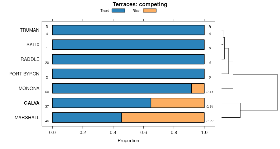
Galva silty clay loam, terrace, 0 to 2 percent slopes | T310 | 353 | 403337 | 2sqq5 | ia021 | 1973 | 1:15840 |
Galva silty clay loam, 5 to 9 percent slopes, eroded | 310C2 | 327 | 403293 | 2sqq2 | ia021 | 1973 | 1:15840 |
Galva silty clay loam, 2 to 5 percent slopes | 310B | 99488 | 403924 | 2sy4p | ia035 | 1987 | 1:15840 |
Galva silty clay loam, 5 to 9 percent slopes, eroded | 310C2 | 38389 | 403927 | 2sqq2 | ia035 | 1987 | 1:15840 |
Galva silty clay loam, 5 to 9 percent slopes | 310C | 27418 | 403926 | 2sqq1 | ia035 | 1987 | 1:15840 |
Galva silty clay loam, 2 to 5 percent slopes, eroded | 310B2 | 17396 | 403925 | 2sqq0 | ia035 | 1987 | 1:15840 |
Galva silty clay loam, 0 to 2 percent slopes | 310 | 8551 | 403923 | 2sqpq | ia035 | 1987 | 1:15840 |
Galva silty clay loam, terrace, 0 to 2 percent slopes | 810 | 5975 | 403963 | 2sqq5 | ia035 | 1987 | 1:15840 |
Galva silty clay loam, 9 to 14 percent slopes, eroded | 310D2 | 3873 | 403928 | 2sqq4 | ia035 | 1987 | 1:15840 |
Galva silty clay loam, terrace, 2 to 5 percent slopes | 810B | 2866 | 403964 | 2sqq6 | ia035 | 1987 | 1:15840 |
Galva silty clay loam, terrace, 5 to 9 percent slopes, eroded | 810C2 | 816 | 403965 | 2sqq8 | ia035 | 1987 | 1:15840 |
Galva silty clay loam, terrace, 0 to 2 percent slopes | 810 | 572 | 399424 | 2sqq5 | ia041 | 2002 | 1:12000 |
Galva silty clay loam, terrace, 2 to 5 percent slopes | 810B | 75 | 399425 | 2sqq6 | ia041 | 2002 | 1:12000 |
Galva silty clay loam, 2 to 5 percent slopes | 310B | 27777 | 407135 | 2sy4p | ia093 | 1989 | 1:15840 |
Galva silty clay loam, 5 to 9 percent slopes, eroded | 310C2 | 23606 | 407138 | 2sqq2 | ia093 | 1989 | 1:15840 |
Galva silty clay loam, 5 to 9 percent slopes | 310C | 18997 | 407137 | 2sqq1 | ia093 | 1989 | 1:15840 |
Galva silty clay loam, 2 to 5 percent slopes, eroded | 310B2 | 7325 | 407136 | 2sqq0 | ia093 | 1989 | 1:15840 |
Galva silty clay loam, 9 to 14 percent slopes, eroded | 310D2 | 5943 | 407140 | 2sqq4 | ia093 | 1989 | 1:15840 |
Galva silty clay loam, terrace, 2 to 5 percent slopes | 810B | 2894 | 407215 | 2sqq6 | ia093 | 1989 | 1:15840 |
Galva silty clay loam, terrace, 0 to 2 percent slopes | 810 | 1619 | 407214 | 2sqq5 | ia093 | 1989 | 1:15840 |
Galva silty clay loam, 0 to 2 percent slopes | 310 | 886 | 407134 | 2sqpq | ia093 | 1989 | 1:15840 |
Galva silty clay loam, terrace, 5 to 9 percent slopes, eroded | 810C2 | 548 | 407218 | 2sqq8 | ia093 | 1989 | 1:15840 |
Galva silty clay loam, 9 to 14 percent slopes | 310D | 350 | 407139 | 2sqq3 | ia093 | 1989 | 1:15840 |
Galva silty clay loam, 2 to 5 percent slopes | 310B | 36117 | 409094 | 2sy4p | ia119 | 1973 | 1:15840 |
Galva silty clay loam, 0 to 2 percent slopes | 310 | 11548 | 409093 | 2sqpq | ia119 | 1973 | 1:15840 |
Galva silty clay loam, 2 to 5 percent slopes, eroded | 310B2 | 11227 | 409095 | 2sqq0 | ia119 | 1973 | 1:15840 |
Galva silty clay loam, 5 to 9 percent slopes, eroded | 310C2 | 5411 | 409096 | 2sqq2 | ia119 | 1973 | 1:15840 |
Galva silty clay loam, stratified substratum, 0 to 2 percent slopes | 311 | 5029 | 409097 | 2sqq9 | ia119 | 1973 | 1:15840 |
Galva silty clay loam, stratified substratum, 2 to 5 percent slopes | 311B | 1218 | 409098 | 2sqqb | ia119 | 1973 | 1:15840 |
Galva silty clay loam, 2 to 5 percent slopes | 310B | 100985 | 410069 | 2sy4p | ia141 | 1977 | 1:15840 |
Galva silty clay loam, 0 to 2 percent slopes | 310 | 11759 | 410068 | 2sqpq | ia141 | 1977 | 1:15840 |
Galva silty clay loam, stratified substratum, 0 to 2 percent slopes | 311 | 6169 | 410071 | 2sqq9 | ia141 | 1977 | 1:15840 |
Galva silty clay loam, stratified substratum, 2 to 5 percent slopes | 311B | 1236 | 410072 | 2sqqb | ia141 | 1977 | 1:15840 |
Galva silty clay loam, 5 to 9 percent slopes, eroded | 310C2 | 654 | 410070 | 2sqq2 | ia141 | 1977 | 1:15840 |
Galva silty clay loam, 2 to 5 percent slopes | 310B | 4427 | 410135 | 2sy4p | ia143 | 1985 | 1:15840 |
Galva silty clay loam, 0 to 2 percent slopes | 310 | 3000 | 410134 | 2sqpq | ia143 | 1985 | 1:15840 |
Galva silty clay loam, stratified substratum, 0 to 2 percent slopes | 311 | 2974 | 410136 | 2sqq9 | ia143 | 1985 | 1:15840 |
Galva silty clay loam, stratified substratum, 2 to 5 percent slopes | 311B | 956 | 410137 | 2sqqb | ia143 | 1985 | 1:15840 |
Galva silty clay loam, 5 to 9 percent slopes, eroded | 310C2 | 129207 | 410341 | 2sqq2 | ia149 | 1972 | 1:20000 |
Galva silty clay loam, 2 to 5 percent slopes | 310B | 109703 | 410340 | 2sy4p | ia149 | 1972 | 1:20000 |
Galva silty clay loam, terrace, 2 to 5 percent slopes | T310B | 21992 | 410364 | 2sqq6 | ia149 | 1972 | 1:20000 |
Galva silty clay loam, 9 to 14 percent slopes, eroded | 310D2 | 9792 | 410342 | 2sqq4 | ia149 | 1972 | 1:20000 |
Galva silty clay loam, terrace, 0 to 2 percent slopes | T310 | 4298 | 410363 | 2sqq5 | ia149 | 1972 | 1:20000 |
Galva-Wadena complex, 5 to 14 percent slopes, moderately eroded | 317C2 | 1091 | 410343 | frzw | ia149 | 1972 | 1:20000 |
Galva silty clay loam, 2 to 5 percent slopes | 310B | 50195 | 410792 | 2sy4p | ia161 | 1975 | 1:15840 |
Galva silty clay loam, 5 to 9 percent slopes, eroded | 310C2 | 4062 | 410795 | 2sqq2 | ia161 | 1975 | 1:15840 |
Galva silty clay loam, 5 to 9 percent slopes | 310C | 2782 | 410794 | 2sqq1 | ia161 | 1975 | 1:15840 |
Galva silty clay loam, terrace, 0 to 2 percent slopes | T310 | 1425 | 410852 | 2sqq5 | ia161 | 1975 | 1:15840 |
Galva silty clay loam, 0 to 2 percent slopes | 310 | 1211 | 410791 | 2sqpq | ia161 | 1975 | 1:15840 |
Galva silty clay loam, terrace, 2 to 5 percent slopes | T310B | 725 | 410853 | 2sqq6 | ia161 | 1975 | 1:15840 |
Galva silty clay loam, 2 to 5 percent slopes, eroded | 310B2 | 468 | 410793 | 2sqq0 | ia161 | 1975 | 1:15840 |
Galva silty clay loam, 2 to 5 percent slopes, eroded | 310B2 | 108513 | 411216 | 2sqq0 | ia167 | 1987 | 1:15840 |
Galva silty clay loam, 2 to 5 percent slopes | 310B | 70616 | 411215 | 2sy4p | ia167 | 1987 | 1:15840 |
Galva silty clay loam, 5 to 9 percent slopes, eroded | 310C2 | 34195 | 411217 | 2sqq2 | ia167 | 1987 | 1:15840 |
Galva silty clay loam, 0 to 2 percent slopes | 310 | 18694 | 411214 | 2sqpq | ia167 | 1987 | 1:15840 |
Galva silty clay loam, terrace, 0 to 2 percent slopes | 810 | 10732 | 411260 | 2sqq5 | ia167 | 1987 | 1:15840 |
Galva silty clay loam, terrace, 2 to 5 percent slopes | 810B | 6913 | 411261 | 2sqq6 | ia167 | 1987 | 1:15840 |
Galva silty clay loam, terrace, 2 to 5 percent slopes, eroded | 810B2 | 2726 | 411262 | 2sqq7 | ia167 | 1987 | 1:15840 |
Galva silty clay loam, 9 to 14 percent slopes, eroded | 310D2 | 837 | 411218 | 2sqq4 | ia167 | 1987 | 1:15840 |
Galva silty clay loam, 5 to 9 percent slopes, eroded | 310C2 | 12563 | 401991 | 2sqq2 | ia193 | 2003 | 1:12000 |
Galva silty clay loam, 2 to 5 percent slopes | 310B | 9946 | 401896 | 2sy4p | ia193 | 2003 | 1:12000 |
Galva silty clay loam, terrace, 2 to 5 percent slopes | 810B | 464 | 441313 | 2sqq6 | ia193 | 2003 | 1:12000 |
Galva silty clay loam, terrace, 5 to 9 percent slopes, eroded | 810C2 | 124 | 441315 | 2sqq8 | ia193 | 2003 | 1:12000 |
Galva silty clay loam, 2 to 5 percent slopes | P15B | 214 | 630068 | p4ms | mn105 | 2004 | 1:12000 |
Galva silty clay loam, 2 to 5 percent slopes | P15B | 9083 | 432724 | gj8v | mn133 | 2002 | 1:12000 |
Galva silty clay loam, 5 to 9 percent slopes, eroded | P15C2 | 229 | 432723 | 2sqq2 | mn133 | 2002 | 1:12000 |

