Official Series Description


Lab Data Summary

Aggregate lab data for the GALE soil series. This aggregation is based on all pedons with a current taxon name of GALE, and applied along 1-cm thick depth slices. Solid lines are the slice-wise median, bounded on either side by the interval defined by the slice-wise 5th and 95th percentiles. The median is the value that splits the data in half. Five percent of the data are less than the 5th percentile, and five percent of the data are greater than the 95th percentile. Values along the right hand side y-axis describe the proportion of pedon data that contribute to aggregate values at this depth. For example, a value of "90%" at 25cm means that 90% of the pedons correlated to GALE were used in the calculation. Source: KSSL snapshot . Methods used to assemble the KSSL snapshot used by SoilWeb / SDE

Click the image to view it full size.

Pedons used in the lab summary:

MLRALab IDPedon IDTaxonnameCINSSL / NASIS ReportsLink To SoilWeb GMap
10578P0042S1977WI065001GALE6Primary | Supplementary | Taxonomy | Pedon | Water Retention | Correlation | Andic Soil Properties42.7386093,-89.8577805

Water Balance

Monthly water balance estimated using a leaky-bucket style model for the GALE soil series. Monthly precipitation (PPT) and potential evapotranspiration (PET) have been estimated from the 50th percentile of gridded values (PRISM 1981-2010) overlapping with the extent of SSURGO map units containing each series as a major component. Monthly PET values were estimated using the method of Thornthwaite (1948). These (and other) climatic parameters are calculated with each SSURGO refresh and provided by the fetchOSD function of the soilDB package. Representative water storage values (“AWC” in the figures) were derived from SSURGO by taking the 50th percentile of profile-total water storage (sum[awc_r * horizon thickness]) for each soil series. Note that this representation of “water storage” is based on the average ability of most plants to extract soil water between 15 bar (“permanent wilting point”) and 1/3 bar (“field capacity”) matric potential. Soil moisture state can be roughly interpreted as “dry” when storage is depleted, “moist” when storage is between 0mm and AWC, and “wet” when there is a surplus. Clearly there are a lot of assumptions baked into this kind of monthly water balance. This is still a work in progress.

Click the image to view it full size.


Click the image to view it full size.

Sibling Summary

Siblings are those soil series that occur together in map units, in this case with the GALE series. Sketches are arranged according to their subgroup-level taxonomic structure. Source: SSURGO snapshot , parsed OSD records and snapshot of SC database .

Click the image to view it full size.

Select annual climate data summaries for the GALE series and siblings. Series are sorted according to hierarchical clustering of median values. Source: SSURGO map unit geometry and 1981-2010, 800m PRISM data .

Click the image to view it full size.

Geomorphic description summaries for the GALE series and siblings. Series are sorted according to hierarchical clustering of proportions and relative hydrologic position within an idealized landform (e.g. top to bottom). Most soil series (SSURGO components) are associated with a hillslope position and one or more landform-specific positions: hills, mountain slopes, terraces, and/or flats. Proportions can be interpreted as an aggregate representation of geomorphic membership. The values printed to the left (number of component records) and right (Shannon entropy) of stacked bars can be used to judge the reliability of trends. Small Shannon entropy values suggest relatively consistent geomorphic association, while larger values suggest lack thereof. Source: SSURGO component records .

Click the image to view it full size.

Click the image to view it full size.

There are insufficient data to create the 3D mountains figure.

Click the image to view it full size.

Click the image to view it full size.

Competing Series

Soil series competing with GALE share the same family level classification in Soil Taxonomy. Source: parsed OSD records and snapshot of the SC database .

Click the image to view it full size.

Select annual climate data summaries for the GALE series and competing. Series are sorted according to hierarchical clustering of median values. Source: SSURGO map unit geometry and 1981-2010, 800m PRISM data .

Click the image to view it full size.

Geomorphic description summaries for the GALE series and competing. Series are sorted according to hierarchical clustering of proportions and relative hydrologic position within an idealized landform (e.g. top to bottom). Proportions can be interpreted as an aggregate representation of geomorphic membership. Most soil series (SSURGO components) are associated with a hillslope position and one or more landform-specific positions: hills, mountain slopes, terraces, and/or flats. The values printed to the left (number of component records) and right (Shannon entropy) of stacked bars can be used to judge the reliability of trends. Shannon entropy values close to 0 represent soil series with relatively consistent geomorphic association, while values close to 1 suggest lack thereof. Source: SSURGO component records .

Click the image to view it full size.

Click the image to view it full size.

There are insufficient data to create the 3D mountains figure.

There are insufficient data to create the 3D terrace figure.

There are insufficient data to create the 3D flats position figure.

Soil series sharing subgroup-level classification with GALE, arranged according to family differentiae. Hovering over a series name will print full classification and a small sketch from the OSD. Source: snapshot of SC database .

Block Diagrams

Click a link below to display the diagram. Note that these diagrams may be from multiple survey areas.

  1. WI-2012-03-22-02 | Buffalo County - March 1962

    Soil associations and relief in Buffalo County. 1. Silty soils of the rolling limestone uplands and Steep stony and rocky land: Dubuque, Fayette, Steep stony and rocky land. 2. Loamy soils of the rolling to hilly sandstone uplands: Gale, Hixton. 3. Sandy soils of the rolling to hilly sandstone uplands: Boone, Hixton. 4. Sandy soils of stream terraces: Sparta, Plainfield. 5. Silty soils of stream terraces: Bertrand, Richwood. 6. Loamy terrace soils underlain by sand on stream terraces: Meridian, Tell. 7. Wet organic and mineral soils of bottom lands: Peat and Muck, Ettrick, Wallkill. 8. Soils of overflow bottom lands: Loamy alluvial lands, Marsh (Soil Survey of Bayfield County, WI; 1961).

  2. WI-2012-03-22-03 | Buffalo County - March 1962

    Soil landscape of Buffalo County showing relationships among major soil series (Soil Survey of Buffalo County, WI; 1962).

  3. WI-2012-03-22-04 | Crawford County - December 1961

    Landscape of Crawford County showing the parent materials of the soils and relationships among major soil series (Soil Survey of Crawford County, WI; 1961).

  4. WI-2012-03-23-04 | Jackson County - 2001

    Relationship of soils, topography, and parent material in the Seaton-Council association (Soil Survey of Jackson County, WI; 2001).

Map Units

Map units containing GALE as a major component. Limited to 250 records.

Map Unit Name Symbol Map Unit Area (ac) Map Unit Key National Map Unit Symbol Soil Survey Area Publication Date Map Scale
Gale silt loam, 18 to 40 percent slopes479G535409987frmdia13919861:15840
Fayette-Gale silt loams, 5 to 10 percent slopes, eroded798C25213857931hj10il01520051:12000
Gale silt loam, 2 to 4 percent slopes413B4042635288v6xil09920061:12000
Gale silt loam, 4 to 6 percent slopes, eroded413C223414277911jxqsil09920061:12000
Gale-Oak Center complex, 1 to 6 percent slopesN526B31516699891t1rmmn04920071:12000
Gale-Oak Center complex, 18 to 45 percent slopesN526F9717130771vhlkmn04920071:12000
Gale-Hixton complex, shallow, 12 to 18 percent slopes, moderately erodedGhD227222163742dd9ymn15720081:12000
Gale silt loam, 6 to 12 percent slopes, moderately erodedGaC219822163732tc69mn15720081:12000
Gale-Hixton complex, shallow, 6 to 12 percent slopes, moderately erodedGhC217822163762ddb0mn15720081:12000
Gale-Hixton complex, shallow, 18 to 25 percent slopesGhE15322163752dd9zmn15720081:12000
Gale silt loam, 2 to 6 percent slopes, moderately erodedGaB215322163722tc6dmn15720081:12000
Gale-Oak Center complex, 18 to 45 percent slopesN526F14622161512dd2rmn15720081:12000
Gale silt loam, 12 to 20 percent slopes, moderately erodedGaD210322163712tc6bmn15720081:12000
Gale silt loam, 25 to 50 percent slopes174F69816770801t94cmn16319781:15840
Gale silt loam, 6 to 15 percent slopes174C44916770791t94bmn16319781:15840
Gale silt loam, 12 to 20 percent slopes, moderately eroded174D216514289932tc6bmn16919871:20000
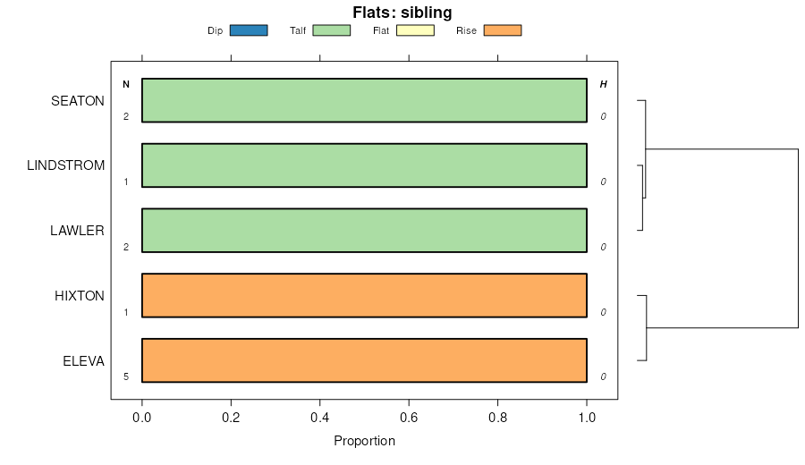
Seaton-Gale silt loams, 6 to 12 percent slopes829C1256429094gdhrmn16919871:20000
Gale-Blackhammer silt loams, 6 to 12 percent slopes826C1023429093gdhqmn16919871:20000
Gale-Blackhammer silt loams, 2 to 6 percent slopes826B249429092gdhpmn16919871:20000
Gale silt loam, 20 to 30 percent slopes, moderately eroded214E250025617302tc6cwi01119601:20000
Gale silt loam, 12 to 20 percent slopes, moderately eroded214D241925617292tc6bwi01119601:20000
Gale silt loam, 6 to 12 percent slopes, moderately eroded214C222925617282tc69wi01119601:20000
Gale silt loam, 2 to 6 percent slopes, moderately eroded214B214125617272tc6dwi01119601:20000
Gale silt loam, 12 to 20 percent slopes, moderately eroded214D296325039372tc6bwi02319601:12000
Gale silt loam, 20 to 30 percent slopes, moderately eroded214E232225039392tc6cwi02319601:12000
Gale silt loam, 6 to 12 percent slopes, moderately eroded214C221125039352tc69wi02319601:12000
Gale silt loam, 2 to 6 percent slopes, moderately eroded214B22425039332tc6dwi02319601:12000
Gale silt loam, 6 to 12 percent slopes, moderately erodedGaC226297535092tc69wi02519721:15840
Gale silt loam, 2 to 6 percent slopes, moderately erodedGaB215707535082tc6dwi02519721:15840
Gale silt loam, 12 to 20 percent slopes, moderately erodedGaD26727535102tc6bwi02519721:15840
Gale silt loam, 12 to 20 percent slopes, moderately erodedGaD252044242392tc6bwi04319591:20000
Gale silt loam, 20 to 30 percent slopes, moderately erodedGaF210524242442tc6cwi04319591:20000
Gale silt loam, 6 to 12 percent slopes, moderately erodedGaC210144242372tc69wi04319591:20000
Gale silt loam, 6 to 12 percent slopes, moderately erodedGaC220214252712tc69wi04519691:12000
Gale silt loam, 2 to 6 percent slopes, moderately erodedGaB211324252702tc6dwi04519691:12000
Gale silt loam, 12 to 20 percent slopes, moderately erodedGaD29064252722tc6bwi04519691:12000
Gale silt loam, 20 to 30 percent slopes, moderately erodedGaE21204252732tc6cwi04519691:12000
Gale silt loam, 12 to 20 percent slopes, moderately eroded214D2859727748032tc6bwi04919601:20000
Gale silt loam, 20 to 30 percent slopes, moderately eroded214E2305527748042tc6cwi04919601:20000
Gale silt loam, 6 to 12 percent slopes, moderately eroded214C2267227748022tc69wi04919601:20000
Gale silt loam, 2 to 6 percent slopes, moderately eroded214B228227748012tc6dwi04919601:20000
Gale silt loam, 6 to 12 percent slopes, moderately erodedGaC28954248202tc69wi06519641:15840
Gale silt loam, 12 to 20 percent slopes, moderately erodedGaD25564248212tc6bwi06519641:15840
Gale silt loam, 20 to 30 percent slopes, moderately erodedGaE21394248222tc6cwi06519641:15840
Gale silt loam, 12 to 20 percent slopes, moderately eroded214D286625039382tc6bwi12319651:12000
Gale silt loam, 6 to 12 percent slopes, moderately eroded214C250325039362tc69wi12319651:12000
Gale silt loam, 20 to 30 percent slopes, moderately eroded214E220525039402tc6cwi12319651:12000
Gale silt loam, 2 to 6 percent slopes, moderately eroded214B28425039342tc6dwi12319651:12000

Map of Series Extent

Approximate geographic distribution of the GALE soil series. To learn more about how this distribution was mapped, or to compare this soil series extent to others, use the Series Extent Explorer (SEE) application. Source: generalization of SSURGO geometry .