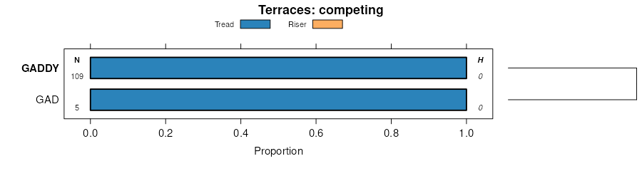
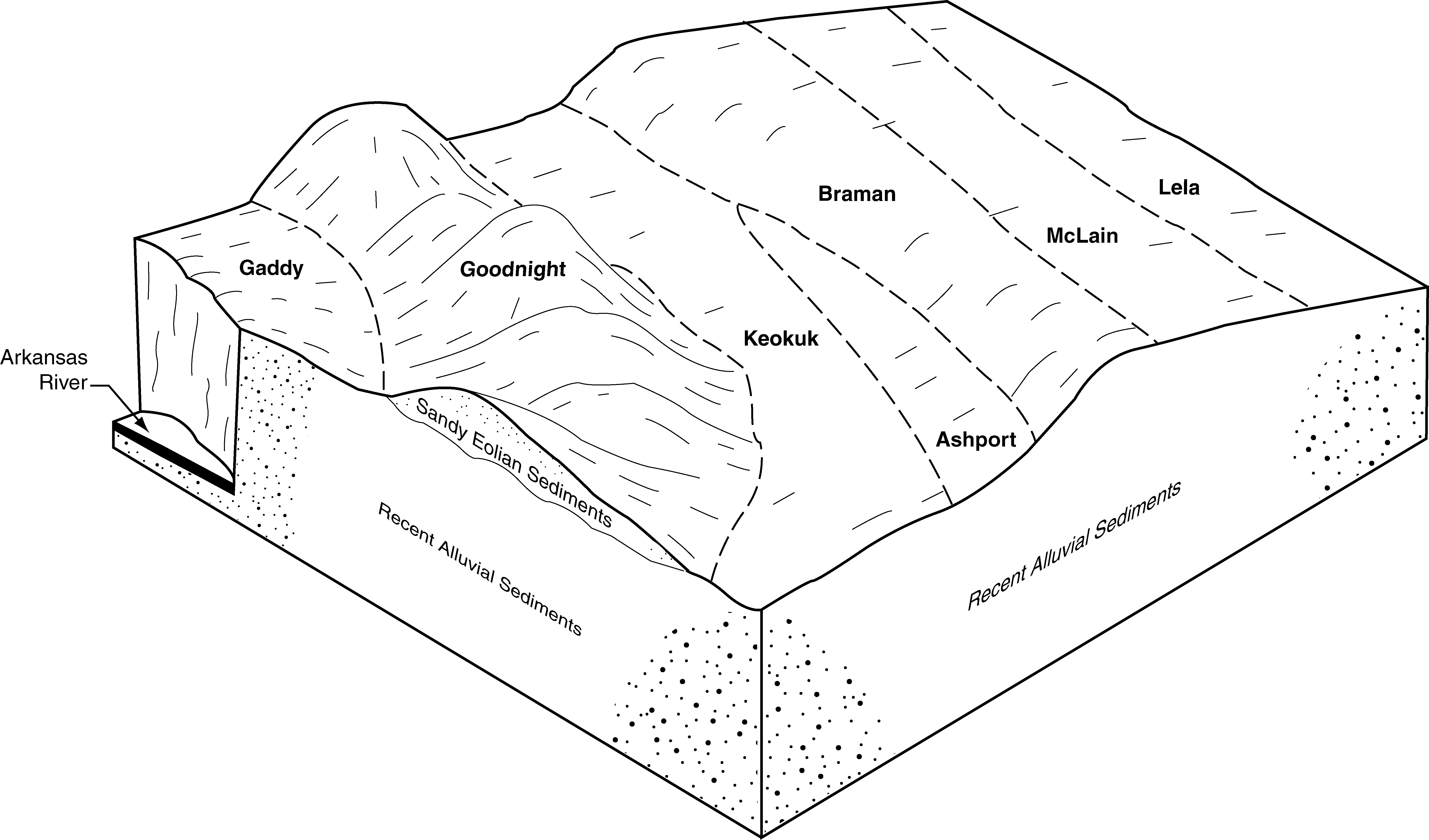
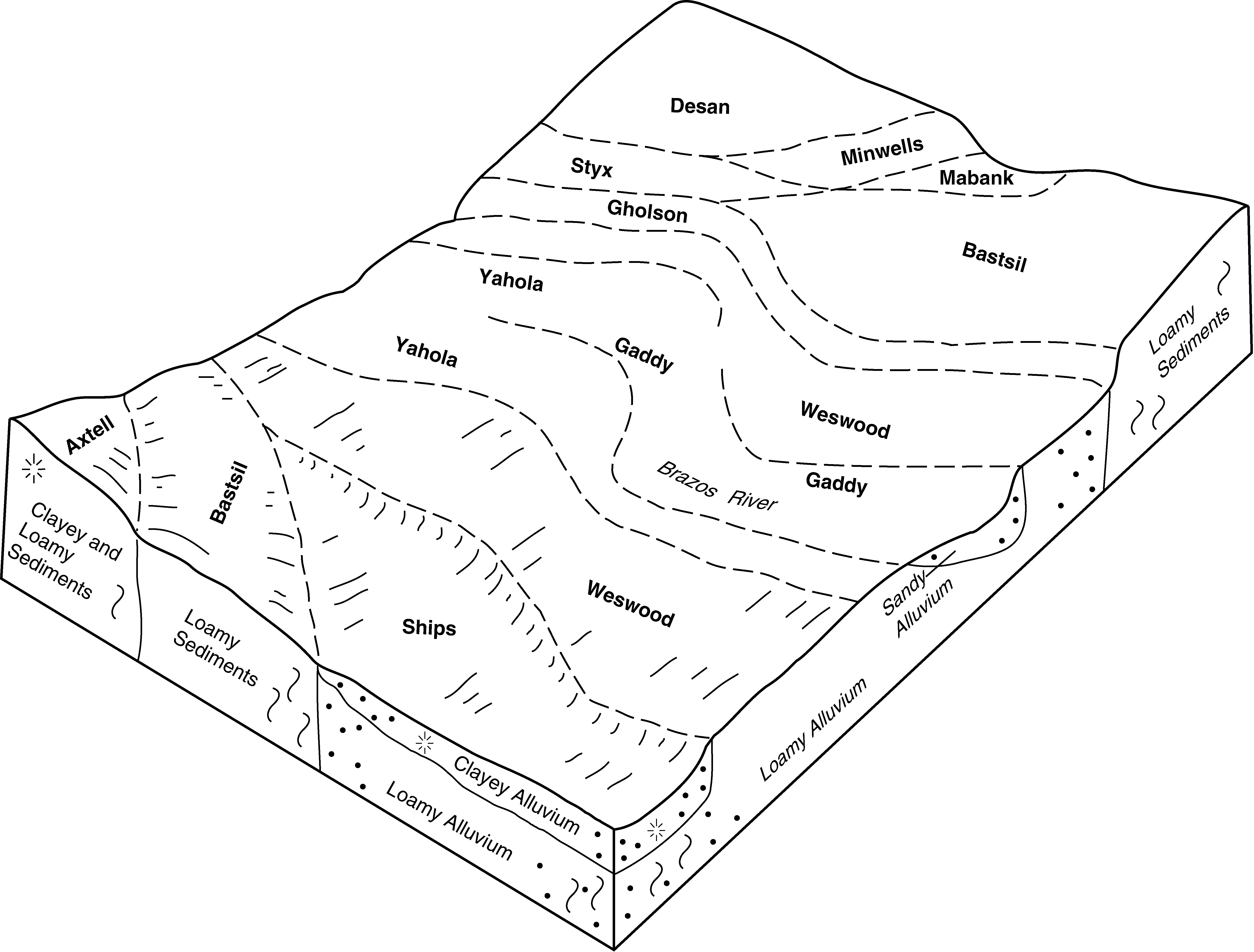
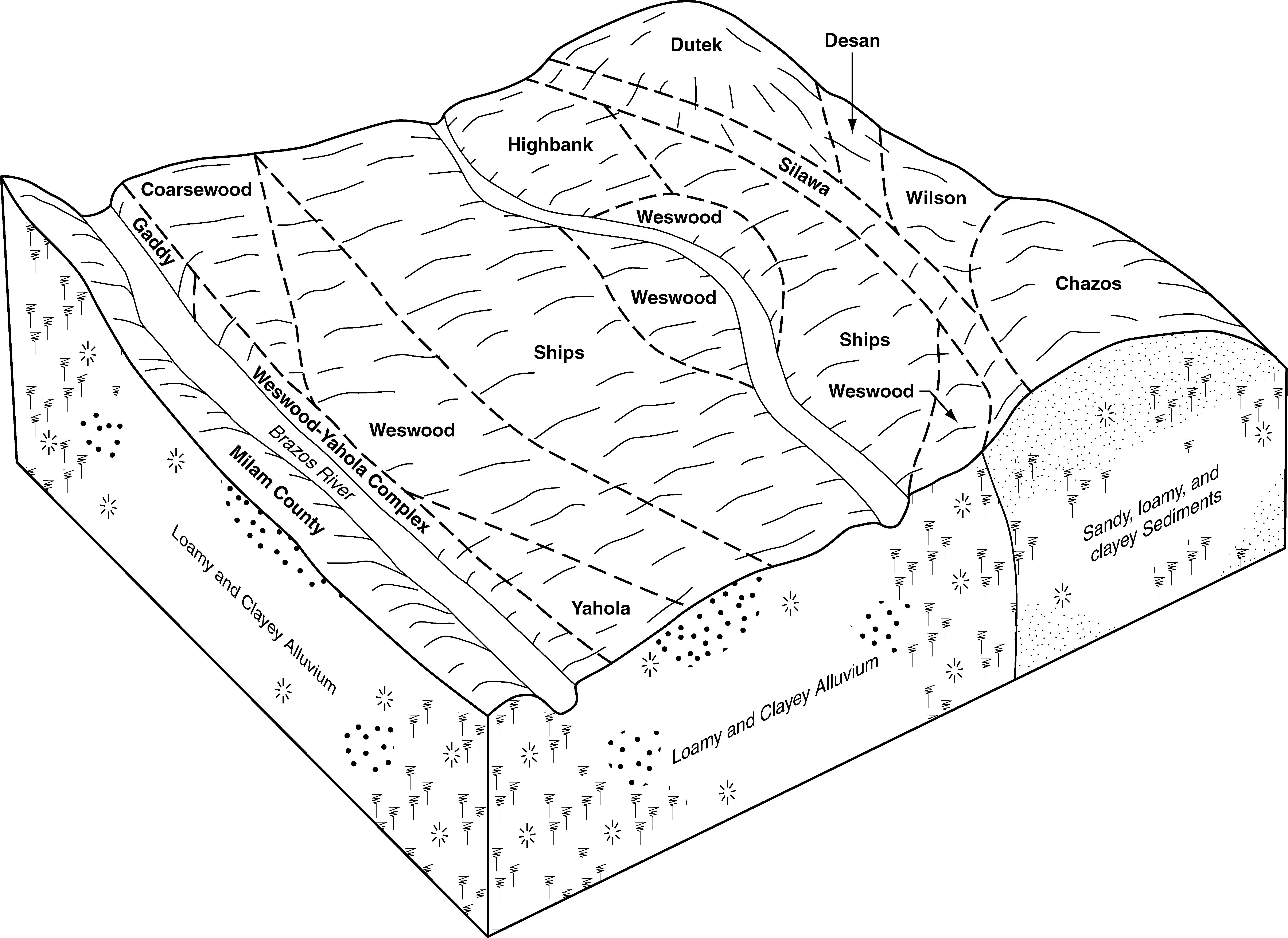
| Gaddy loamy fine sand, 0 to 1 percent slopes, frequently flooded | Ls | 3978 | 381431 | 2tp6q | ok003 | 1971 | 1:24000 |
Gaddy loamy fine sand, 0 to 1 percent slopes, occasionally flooded | Ln | 8686 | 381740 | 2tp6r | ok011 | 1965 | 1:24000 |
Gracemore-Gaddy complex, 0 to 1 percent slopes, occasionally flooded | 4 | 2129 | 382107 | dtm1 | ok027 | 1984 | 1:24000 |
Yahola-Gaddy complex, 0 to 1 percent slopes, frequently flooded | 85 | 6474 | 382621 | dv4m | ok049 | 1982 | 1:24000 |
Gaddy loamy fine sand, 0 to 1 percent slopes, occasionally flooded | 10 | 2575 | 382697 | 2tp6r | ok053 | 1983 | 1:24000 |
Gaddy fine sand, 0 to 1 percent slopes, frequently flooded | 9 | 1920 | 382750 | 2tp6t | ok053 | 1983 | 1:24000 |
Gaddy fine sand, 0 to 1 percent slopes, frequently flooded | Cr | 19310 | 383223 | 2tp6t | ok067 | 1967 | 1:24000 |
Gaddy loamy fine sand, 0 to 1 percent slopes, occasionally flooded | Yf | 1245 | 383383 | 2tp6r | ok071 | 1965 | 1:24000 |
Gaddy fine sand, 0 to 1 percent slopes, frequently flooded | Lm | 691 | 383339 | 2tp6t | ok071 | 1965 | 1:24000 |
Gaddy loamy fine sand, 0 to 1 percent slopes, occasionally flooded | Lc | 6284 | 383399 | 2tp6r | ok073 | 1960 | 1:24000 |
Gaddy and Gracemore soils, 0 to 1 percent slopes, frequently flooded | Ln | 5776 | 383400 | dvyr | ok073 | 1960 | 1:24000 |
Gaddy loamy fine sand, 0 to 1 percent slopes, occasionally flooded | Cr | 202 | 383506 | 2tp6r | ok081 | 1966 | 1:24000 |
Gaddy-Gracemore complex, 0 to 1 percent slopes, frequently flooded | GaGA | 1822 | 383615 | 30x61 | ok083 | 1994 | 1:12000 |
Gaddy loamy fine sand, 0 to 1 percent slopes, occasionally flooded | GadA | 1220 | 383616 | 2tp6r | ok083 | 1994 | 1:12000 |
Gaddy loam, 0 to 1 percent slopes, frequently flooded | Ls | 10928 | 383722 | dw94 | ok085 | 1963 | 1:24000 |
Gaddy-Gracemore complex, 0 to 1 percent slopes, occasionally flooded | 9 | 3146 | 383810 | 30x62 | ok087 | 1976 | 1:24000 |
Gaddy fine sand, 0 to 1 percent slopes, frequently flooded | Ls | 17556 | 383836 | 2tp6t | ok093 | 1965 | 1:24000 |
Gaddy loam, 0 to 1 percent slopes, occasionally flooded | Ln | 2830 | 383835 | dwds | ok093 | 1965 | 1:24000 |
Gaddy loamy fine sand, 0 to 1 percent slopes, occasionally flooded | GadA | 596 | 384053 | 2tp6r | ok103 | 1994 | 1:24000 |
Gaddy loamy fine sand, 0 to 1 percent slopes, rarely flooded | GayA | 104 | 384054 | dwmv | ok103 | 1994 | 1:24000 |
Gaddy loamy fine sand, 0 to 1 percent slopes, frequently flooded | GdyA | 1626 | 384162 | 2tp6q | ok107 | 1996 | 1:24000 |
Gaddy loamy fine sand, 0 to 1 percent slopes, occasionally flooded | GadA | 1103 | 384158 | 2tp6r | ok107 | 1996 | 1:24000 |
Gaddy-Gracemore complex, 0 to 1 percent slopes, frequently flooded | GaGA | 3017 | 384292 | 30x61 | ok109 | 1996 | 1:12000 |
Yahola-Gaddy complex, 0 to 1 percent slopes, occasionally flooded | YaGA | 677 | 384375 | dwz6 | ok109 | 1996 | 1:12000 |
Gaddy loamy fine sand, 0 to 1 percent slopes, frequently flooded | 27 | 5698 | 623422 | 2tp6q | ok113 | 1975 | 1:24000 |
Gaddy fine sandy loam, 0 to 1 percent slopes, occasionally flooded | 52 | 2546 | 623447 | nxr6 | ok113 | 1975 | 1:24000 |
Gaddy loamy fine sand, 0 to 1 percent slopes, occasionally flooded | 26 | 2472 | 623421 | 2tp6r | ok113 | 1975 | 1:24000 |
Gaddy loamy fine sand, 0 to 1 percent slopes, occasionally flooded | GadA | 1539 | 1423156 | 2tp6r | ok117 | 2007 | 1:24000 |
Gaddy loamy fine sand, 0 to 1 percent slopes, frequently flooded | GdyA | 709 | 1887283 | 2tp6q | ok117 | 2007 | 1:24000 |
Gaddy-Gracemore complex, 0 to 1 percent slopes, frequently flooded | 19 | 3032 | 384514 | 30x61 | ok119 | 1983 | 1:24000 |
Gaddy loamy fine sand, 0 to 1 percent slopes, occasionally flooded | 18 | 1629 | 384513 | 2tp6r | ok119 | 1983 | 1:24000 |
Gaddy-Gracemore complex, 0 to 1 percent slopes, frequently flooded | Ln | 3746 | 384636 | 30x61 | ok123 | 1967 | 1:24000 |
Gaddy loamy fine sand, 0 to 1 percent slopes, occasionally flooded | GadA | 7923 | 384674 | 2tp6r | ok125 | 1975 | 1:24000 |
Gaddy loamy fine sand, 0 to 1 percent slopes, occasionally flooded | 12 | 1062 | 384797 | 2tp6r | ok133 | 1976 | 1:24000 |
Gaddy loamy fine sand, 0 to 1 percent slopes, frequently flooded | GdyA | 305 | 385188 | 2tp6q | ok151 | 1995 | 1:24000 |
Yahola-Gaddy complex, frequently flooded | Yg | 991 | 363033 | d5rr | tx035 | 1977 | 1:24000 |
Gaddy loamy fine sand, frequently flooded | Ga | 692 | 363443 | d65z | tx051 | 1994 | 1:24000 |
Gaddy soils, frequently flooded | 25 | 5106 | 364473 | d786 | tx097 | 1973 | 1:24000 |
Gaddy fine sandy loam, 0 to 1 percent slopes, occasionally flooded | 24 | 2220 | 364472 | d785 | tx097 | 1973 | 1:24000 |
Gaddy soils, frequently flooded | 26 | 2808 | 365444 | d88j | tx145 | 1975 | 1:20000 |
Gaddy silt loam, occasionally flooded | 25 | 979 | 365443 | d88h | tx145 | 1975 | 1:20000 |
Yahola-Gaddy complex, occasionally flooded | Ya | 725 | 368221 | dc53 | tx251 | 1981 | 1:20000 |
Yahola-Gaddy complex, occasionally flooded | Yg | 4422 | 370139 | df4z | tx309 | 1992 | 1:24000 |
Gaddy loamy fine sand, frequently flooded | Ga | 413 | 370097 | df3m | tx309 | 1992 | 1:24000 |
Gaddy fine sandy loam, frequently flooded | GaA | 1479 | 370674 | dfq7 | tx331 | 1988 | 1:24000 |
Yahola-Gaddy complex, occasionally flooded | 46 | 5048 | 370793 | dfv2 | tx337 | 1975 | 1:24000 |
Gaddy soils, frequently flooded | 19 | 2307 | 370763 | dft3 | tx337 | 1975 | 1:24000 |
Yahola and Gaddy soils, 0 to 2 percent slopes, occasionally flooded | Yg | 4583 | 390980 | f3v8 | tx363 | 1979 | 1:24000 |
Gaddy soils, 0 to 2 percent slopes, frequently flooded | Lf | 1922 | 390890 | f3rc | tx367 | 1973 | 1:20000 |
Gaddy loamy fine sand, 0 to 2 percent slopes, frequently flooded | Ga | 724 | 371714 | dgss | tx395 | 1996 | 1:24000 |
Gaddy loamy fine sand, 0 to 1 percent slopes, frequently flooded | Ln | 1291 | 393221 | f65k | tx453 | 1969 | 1:20000 |
Gaddy soils and Urban land, 0 to 1 percent slopes, occasionally flooded | Lu | 387 | 393222 | f65l | tx453 | 1969 | 1:20000 |
Yahola-Gaddy complex, occasionally flooded | Yg | 5273 | 374375 | dkkm | tx609 | 1975 | 1:20000 |