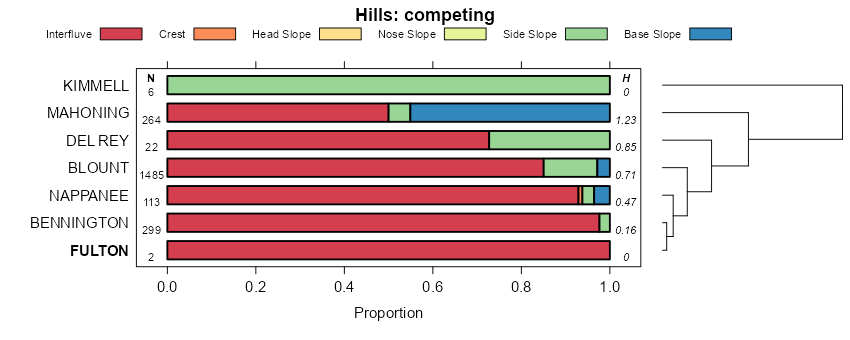
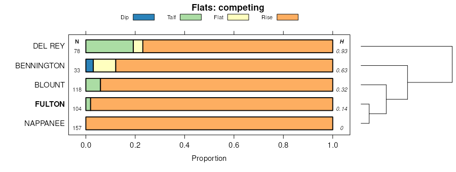
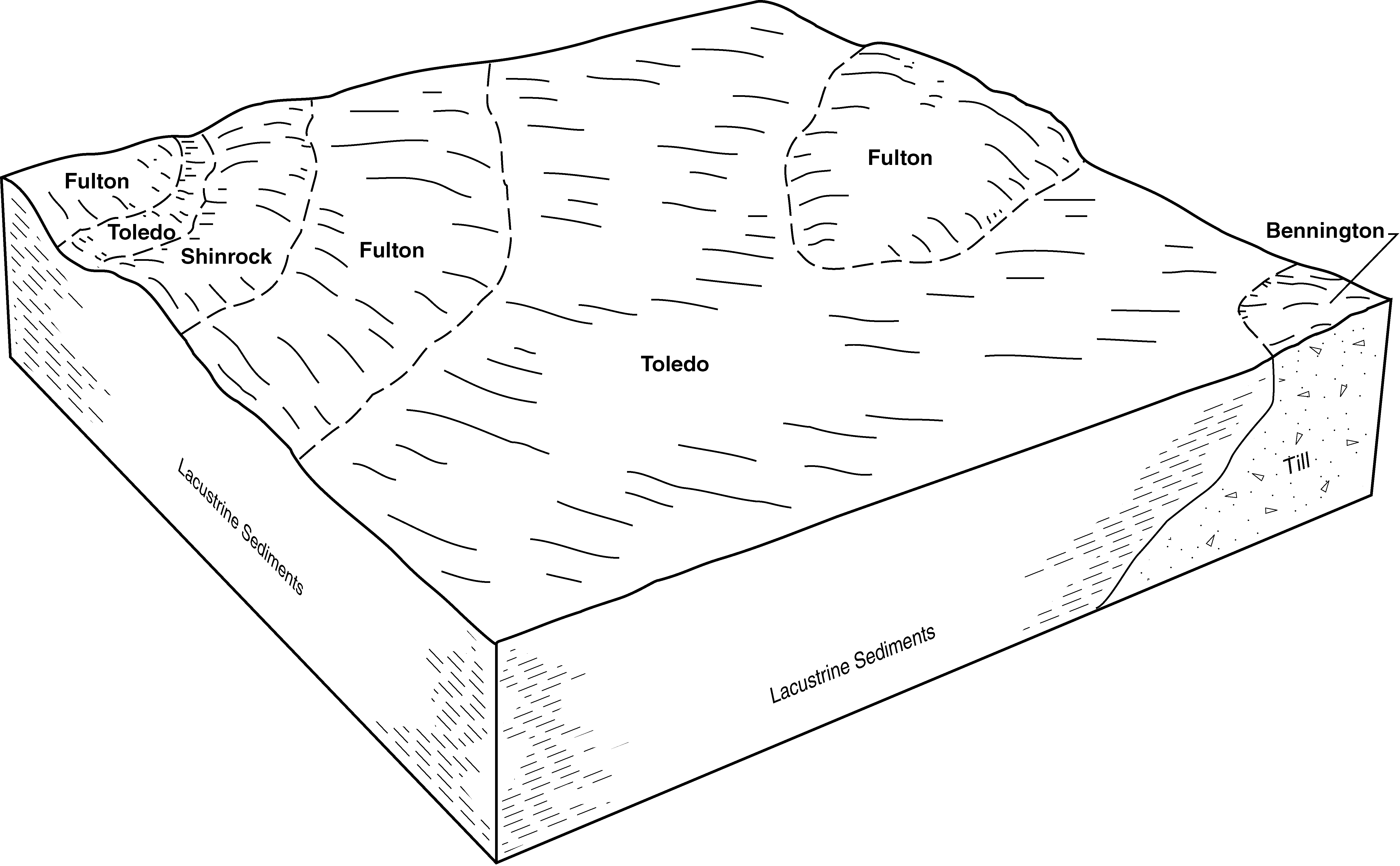
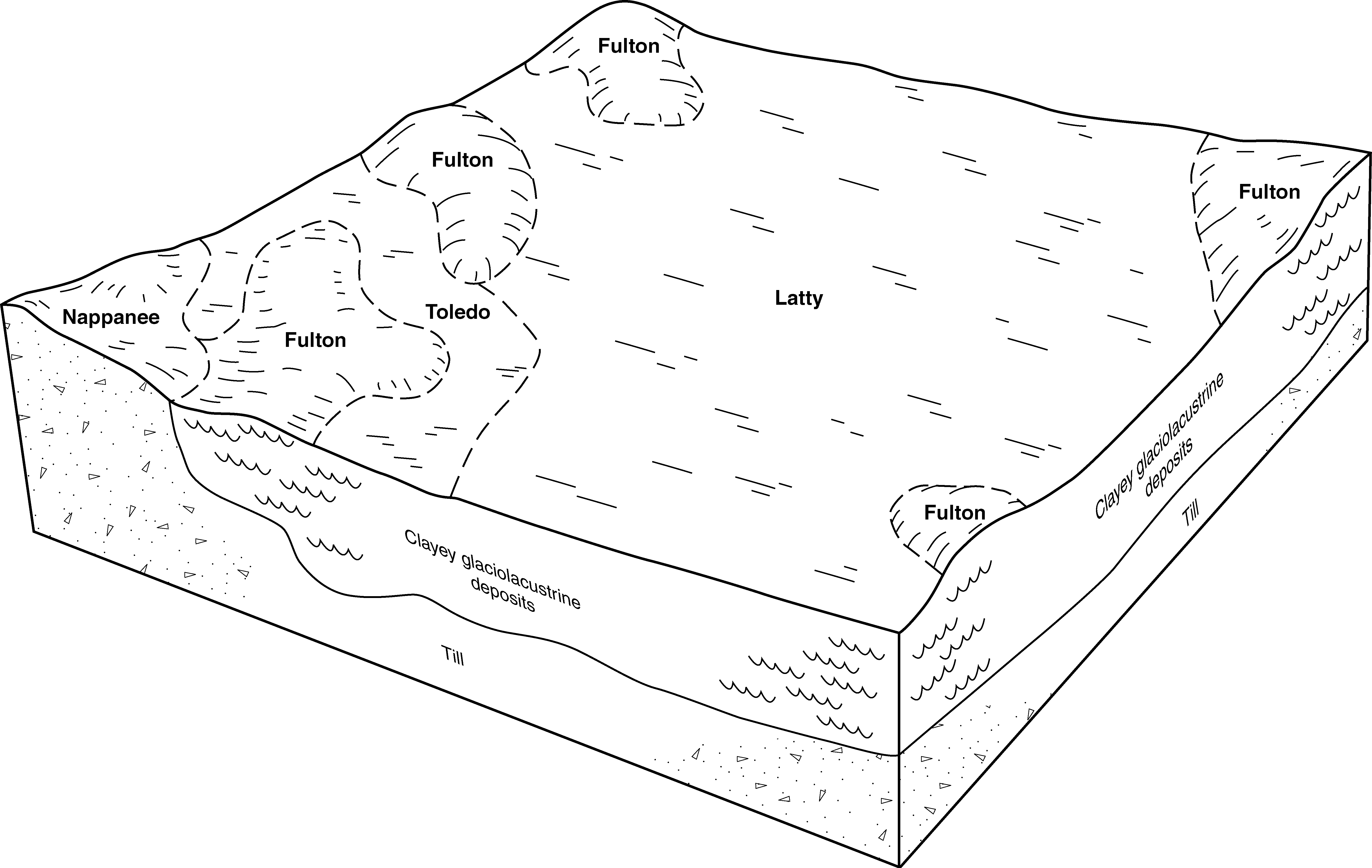
Official Series Description


Lab Data Summary

Aggregate lab data for the FULTON soil series. This aggregation is based on all pedons with a current taxon name of FULTON, and applied along 1-cm thick depth slices. Solid lines are the slice-wise median, bounded on either side by the interval defined by the slice-wise 5th and 95th percentiles. The median is the value that splits the data in half. Five percent of the data are less than the 5th percentile, and five percent of the data are greater than the 95th percentile. Values along the right hand side y-axis describe the proportion of pedon data that contribute to aggregate values at this depth. For example, a value of "90%" at 25cm means that 90% of the pedons correlated to FULTON were used in the calculation. Source: KSSL snapshot . Methods used to assemble the KSSL snapshot used by SoilWeb / SDE

Click the image to view it full size.

Pedons used in the lab summary:

MLRALab IDPedon IDTaxonnameCINSSL / NASIS ReportsLink To SoilWeb GMap
111BSA-0111960-OH147-011Fulton2Primary | Supplementary | Taxonomy | Pedon | Water Retention | Correlation | Andic Soil Properties40.9978752,-83.2870407
111BWY-0051960-OH175-005Fulton2Primary | Supplementary | Taxonomy | Pedon | Water Retention | Correlation | Andic Soil Properties40.932354,-83.3357773
111BWY-0101962-OH175-010Fulton3Primary | Supplementary | Taxonomy | Pedon | Water Retention | Correlation | Andic Soil Properties40.7501411,-83.4796143
111BST76011976IN151001Fulton2Primary | Supplementary | Taxonomy | Pedon | Water Retention | Correlation | Andic Soil Properties41.5637778,-84.867225
99PD-0051953-OH125-005Fulton2Primary | Supplementary | Taxonomy | Pedon | Water Retention | Correlation | Andic Soil Properties41.13414,-84.4254456
99PD-0581955-OH125-058Fulton2Primary | Supplementary | Taxonomy | Pedon | Water Retention | Correlation | Andic Soil Properties41.1381378,-84.3985291
99WD-1041957-OH173-104Fulton3Primary | Supplementary | Taxonomy | Pedon | Water Retention | Correlation | Andic Soil Properties41.6100273,-83.4248352
99WD-1051958-OH173-105Fulton3Primary | Supplementary | Taxonomy | Pedon | Water Retention | Correlation | Andic Soil Properties41.5873604,-83.4475555
99WD-1061958-OH173-106Fulton3Primary | Supplementary | Taxonomy | Pedon | Water Retention | Correlation | Andic Soil Properties41.6009445,-83.4249191
99WD-1151958-OH173-115Fulton3Primary | Supplementary | Taxonomy | Pedon | Water Retention | Correlation | Andic Soil Properties41.6035538,-83.4403305
99WL-0011961-OH171-001Fulton3Primary | Supplementary | Taxonomy | Pedon | Water Retention | Correlation | Andic Soil Properties41.4456482,-84.4773865
99WL-0021961-OH171-002Fulton2Primary | Supplementary | Taxonomy | Pedon | Water Retention | Correlation | Andic Soil Properties41.4280052,-84.4786224
99PT-0261967-OH137-026Fulton4Primary | Supplementary | Taxonomy | Pedon | Water Retention | Correlation | Andic Soil Properties41.0288467,-84.1118011
99WL-0131969-OH171-013Fulton3Primary | Supplementary | Taxonomy | Pedon | Water Retention | Correlation | Andic Soil Properties41.4276237,-84.3721771
99WL-0141969-OH171-014Fulton2Primary | Supplementary | Taxonomy | Pedon | Water Retention | Correlation | Andic Soil Properties41.4354897,-84.4435425
99SN-0131980-OH143-013Fulton4Primary | Supplementary | Taxonomy | Pedon | Water Retention | Correlation | Andic Soil Properties41.4263878,-83.1430588
n/aER-0051954-OH043-005Fulton4Primary | Supplementary | Taxonomy | Pedon | Water Retention | Correlation | Andic Soil Propertiesn/a
n/aER-0091957-OH043-009Fulton3Primary | Supplementary | Taxonomy | Pedon | Water Retention | Correlation | Andic Soil Propertiesn/a
n/aER-0121957-OH043-012Fulton3Primary | Supplementary | Taxonomy | Pedon | Water Retention | Correlation | Andic Soil Propertiesn/a
n/aWD-1071958-OH173-107Fulton3Primary | Supplementary | Taxonomy | Pedon | Water Retention | Correlation | Andic Soil Propertiesn/a
n/aWD-1081958-OH173-108Fulton3Primary | Supplementary | Taxonomy | Pedon | Water Retention | Correlation | Andic Soil Propertiesn/a
n/aLG-0241971-OH091-024Fulton3Primary | Supplementary | Taxonomy | Pedon | Water Retention | Correlation | Andic Soil Propertiesn/a

Water Balance

Monthly water balance estimated using a leaky-bucket style model for the FULTON soil series. Monthly precipitation (PPT) and potential evapotranspiration (PET) have been estimated from the 50th percentile of gridded values (PRISM 1981-2010) overlapping with the extent of SSURGO map units containing each series as a major component. Monthly PET values were estimated using the method of Thornthwaite (1948). These (and other) climatic parameters are calculated with each SSURGO refresh and provided by the fetchOSD function of the soilDB package. Representative water storage values (“AWC” in the figures) were derived from SSURGO by taking the 50th percentile of profile-total water storage (sum[awc_r * horizon thickness]) for each soil series. Note that this representation of “water storage” is based on the average ability of most plants to extract soil water between 15 bar (“permanent wilting point”) and 1/3 bar (“field capacity”) matric potential. Soil moisture state can be roughly interpreted as “dry” when storage is depleted, “moist” when storage is between 0mm and AWC, and “wet” when there is a surplus. Clearly there are a lot of assumptions baked into this kind of monthly water balance. This is still a work in progress.

Click the image to view it full size.


Click the image to view it full size.

Sibling Summary

Siblings are those soil series that occur together in map units, in this case with the FULTON series. Sketches are arranged according to their subgroup-level taxonomic structure. Source: SSURGO snapshot , parsed OSD records and snapshot of SC database .

Click the image to view it full size.

Select annual climate data summaries for the FULTON series and siblings. Series are sorted according to hierarchical clustering of median values. Source: SSURGO map unit geometry and 1981-2010, 800m PRISM data .

Click the image to view it full size.

Geomorphic description summaries for the FULTON series and siblings. Series are sorted according to hierarchical clustering of proportions and relative hydrologic position within an idealized landform (e.g. top to bottom). Most soil series (SSURGO components) are associated with a hillslope position and one or more landform-specific positions: hills, mountain slopes, terraces, and/or flats. Proportions can be interpreted as an aggregate representation of geomorphic membership. The values printed to the left (number of component records) and right (Shannon entropy) of stacked bars can be used to judge the reliability of trends. Small Shannon entropy values suggest relatively consistent geomorphic association, while larger values suggest lack thereof. Source: SSURGO component records .

Click the image to view it full size.

Click the image to view it full size.

There are insufficient data to create the 3D mountains figure.

Click the image to view it full size.

Click the image to view it full size.

Competing Series

Soil series competing with FULTON share the same family level classification in Soil Taxonomy. Source: parsed OSD records and snapshot of the SC database .

Click the image to view it full size.

Select annual climate data summaries for the FULTON series and competing. Series are sorted according to hierarchical clustering of median values. Source: SSURGO map unit geometry and 1981-2010, 800m PRISM data .

Click the image to view it full size.

Geomorphic description summaries for the FULTON series and competing. Series are sorted according to hierarchical clustering of proportions and relative hydrologic position within an idealized landform (e.g. top to bottom). Proportions can be interpreted as an aggregate representation of geomorphic membership. Most soil series (SSURGO components) are associated with a hillslope position and one or more landform-specific positions: hills, mountain slopes, terraces, and/or flats. The values printed to the left (number of component records) and right (Shannon entropy) of stacked bars can be used to judge the reliability of trends. Shannon entropy values close to 0 represent soil series with relatively consistent geomorphic association, while values close to 1 suggest lack thereof. Source: SSURGO component records .

Click the image to view it full size.

Click the image to view it full size.

There are insufficient data to create the 3D mountains figure.

There are insufficient data to create the 3D terrace figure.

Click the image to view it full size.

Soil series sharing subgroup-level classification with FULTON, arranged according to family differentiae. Hovering over a series name will print full classification and a small sketch from the OSD. Source: snapshot of SC database .

Block Diagrams

Click a link below to display the diagram. Note that these diagrams may be from multiple survey areas.

  1. OH-2010-09-29-15 | Erie County - 2006

    Typical pattern of soils and parent material in the Toledo-Fulton association (Soil Survey of Erie County, Ohio; 2006).

  2. OH-2010-09-29-27 | Wood County - 2007

    Typical pattern of soils and parent material in the Latty-Fulton association (Soil Survey of Wood County, Ohio; 2007).

  3. OH-2012-02-16-24 | Defiance County - July 1984

    Typical pattern of soils in the Paulding-Roselms Association (Soil Survey of Defiance County, Ohio; July 1984).

  4. OH-2012-02-16-25 | Defiance County - July 1984

    Typical pattern of soils in the Latty-Fulton Association (Soil Survey of Defiance County, Ohio; July 1984).

  5. OH-2012-02-16-31 | Henry County - November 1974

    Relationship of soils to relief and underlying material in the central part of the county (Soil Survey of Henry County, Ohio; November 1974).

  6. OH-2012-02-16-37 | Sandusky County - July 1987

    Typical pattern of soils and parent material in the Toledo-Fulton association (Soil Survey of Sandusky County, Ohio; July 1987).

  7. OH-2012-02-16-44 | Wood County - December 1966

    Relationship of some local soils to underlying material and relief (Soil Survey of Wood County, Ohio; December 1966).

Map Units

Map units containing FULTON as a major component. Limited to 250 records.

Map Unit Name Symbol Map Unit Area (ac) Map Unit Key National Map Unit Symbol Soil Survey Area Publication Date Map Scale
Fulton silt loamFu37527253394ldin11319741:15840
Fulton silty clay loamFu1891617755fbkin18319851:15840
Fulton silty clay loam, 1 to 5 percent slopesFuB3002508400693vmi08719661:15840
Fulton loam, 0 to 2 percent slopesFuA21821876436980mi09919671:20000
Fulton sandy loam, 0 to 2 percent slopesFtA451187642697zmi09919671:20000
Fulton silty clay loam, 0 to 3 percent slopes15A1231518722568tjmi11519801:15840
Fulton silty clay loam, 1 to 5 percent slopes65B766187514693vmi15719841:15840
Fulton silty clay loam, 0 to 3 percent slopesFtA86361684425n8moh03919811:15840
Fulton loam, 0 to 3 percent slopesFsA44161684415n8loh03919811:15840
Fulton silty clay loam, 0 to 2 percent slopesFuA23115397301np6qoh03919811:15840
Fulton silty clay loam, loamy substratum, 0 to 2 percent slopesFvA2815397311np6roh03919811:15840
Fulton loam, 0 to 2 percent slopesFrA2615397291np6poh03919811:15840
Fulton silty clay loam, 2 to 6 percent slopesFuB115397841np8goh03919811:15840
Fulton silty clay loam, 0 to 2 percent slopesFuA21661721415s3yoh04319981:12000
Fulton silty clay loam, 0 to 2 percent slopesFtA79931690805ny6oh05119811:15840
Fulton silty clay loam, 2 to 6 percent slopesFtB21301690815ny7oh05119811:15840
Fulton silt loam, 0 to 2 percent slopesFsA163644392pmjvoh06319971:12000
Fulton silt loam, 0 to 2 percent slopesFuA18871689335nsgoh06519871:15840
Fulton silt loam, 2 to 6 percent slopesFuB5091689345nshoh06519871:15840
Fulton silty clay loam, 0 to 2 percent slopesFvA2716112251r2m0oh06519871:15840
Fulton silty clay loam, 0 to 2 percent slopesFuA27411689865nv5oh06919681:15840
Fulton loam, 0 to 2 percent slopesFsA20881689845nv3oh06919681:15840
Fulton silty clay loam, 2 to 6 percent slopesFuB4811689875nv6oh06919681:15840
Fulton loam, 2 to 6 percent slopesFsB2911689855nv4oh06919681:15840
Fulton silt loam, 0 to 4 percent slopesFuA25041711165r1woh09119771:15840
Fulton silt loam, 0 to 2 percent slopesFuA10062877639nfpoh09319721:15840
Fulton silt loam, sandy substratum, 0 to 2 percent slopesFvA5742877659nfroh09319721:15840
Fulton silt loam, 2 to 6 percent slopesFuB1252877649nfqoh09319721:15840
Fulton silty clay loam, 0 to 2 percent slopesFuA48891698415pqroh09519781:15840
Fulton-Urban land complex, 0 to 3 percent slopesFwA5761698435pqtoh09519781:15840
Fulton silty clay loam, 2 to 6 percent slopesFuB5501698425pqsoh09519781:15840
Fulton silty clay loam, 0 to 2 percent slopesFtA27771711925r4boh10119841:15840
Fulton silty clay loam, 2 to 6 percent slopesFtB14431711935r4coh10119841:15840
Fulton silty clay loam, loamy substratum, 0 to 2 percent slopesFxA155624456486h5oh12519931:12000
Fulton silty clay loam, 0 to 2 percent slopesFuA146924456286h3oh12519931:12000
Fulton loam, 0 to 2 percent slopesFtA123324456186h2oh12519931:12000
Rimer-Fulton complex, 0 to 2 percent slopesRmA60324459386j3oh12519931:12000
Fulton silty clay loam, loamy substratum, 2 to 6 percent slopesFxB22724456586h6oh12519931:12000
Fulton silty clay loam, 2 to 6 percent slopes, erodedFuB222124456386h4oh12519931:12000
Fulton silty clay loam, 0 to 2 percent slopesFuA67211706335qk9oh13719711:20000
Del Rey-Fulton silt loams, 1 to 6 percent slopesDmB46991706285qk4oh13719711:20000
Fulton silty clay loam, 2 to 6 percent slopesFuB8231706345qkboh13719711:20000
Fulton loam, 0 to 2 percent slopesFtA5671706325qk8oh13719711:20000
Fulton silty clay loam, gravelly substratum, 0 to 2 percent slopesFvA2261706355qkcoh13719711:20000
Fulton silt loam, 0 to 2 percent slopesFsA2915291521nb6hoh13719711:20000
Fulton silty clay loam, loamy substratum, 0 to 2 percent slopesFwA2015291771nb79oh13719711:20000
Fulton silty clay loam, 0 to 3 percent slopesFuA61261695605pfpoh14319831:15840
Fulton silty clay loam, 0 to 2 percent slopesFuA56611681505mz6oh17119751:15840
Fulton loam, 0 to 2 percent slopesFsA14661681485mz4oh17119751:15840
Fulton silty clay loam, 2 to 6 percent slopesFuB11581681515mz7oh17119751:15840
Fulton loam, 2 to 6 percent slopesFsB2951681495mz5oh17119751:15840
Fulton silty clay loam, 0 to 3 percent slopesFvA414140411jgf7oh17119751:15840
Fulton silty clay loam, till substratum, 0 to 2 percent slopesFuA20081682275n1poh17320001:12000
Fulton, till substratum-Urban land complex, 0 to 2 percent slopesFzA16301683125n4foh17320001:12000
Fulton silty clay loam, till substratum, 2 to 6 percent slopesFuB3031682285n1qoh17320001:12000
Fulton silty clay loam, 0 to 2 percent slopesFuA39051696115phboh17519801:15840

Map of Series Extent

Approximate geographic distribution of the FULTON soil series. To learn more about how this distribution was mapped, or to compare this soil series extent to others, use the Series Extent Explorer (SEE) application. Source: generalization of SSURGO geometry .