| Freeburg silt loam, 2 to 5 percent slopes | 64008 | 1802 | 2533380 | 2qp7p | mo019 | 1998 | 1:24000 |
Freeburg silt loam, 3 to 9 percent slopes, rarely flooded | 64019 | 3132 | 885953 | yqx4 | mo027 | 1986 | 1:24000 |
Freeburg silt loam, 0 to 3 percent slopes, rarely flooded | 64001 | 511 | 2533342 | 2qp7j | mo031 | 1978 | 1:24000 |
Freeburg silt loam, 2 to 5 percent slopes | 64008 | 107 | 2533379 | 2qp7p | mo031 | 1978 | 1:24000 |
Freeburg silt loam, 0 to 2 percent slopes, occasionally flooded | 64007 | 3086 | 2533371 | 2zhy3 | mo037 | 1981 | 1:24000 |
Freeburg silt loam, 1 to 3 percent slopes, occasionally flooded | 67030 | 104 | 2579888 | 2r0cc | mo037 | 1981 | 1:24000 |
Freeburg silt loam, 1 to 3 percent slopes | 64002 | 4333 | 2533352 | 2qp7k | mo051 | 2002 | 1:24000 |
Freeburg silt loam, 0 to 2 percent slopes, occasionally flooded | 64007 | 3005 | 2533375 | 2zhy3 | mo051 | 2002 | 1:24000 |
Freeburg silt loam, 1 to 3 percent slopes, occasionally flooded | 67030 | 1834 | 2688244 | 2r0cc | mo051 | 2002 | 1:24000 |
Urban land-Freeburg complex, 0 to 3 percent slopes, rarely flooded | 64010 | 1319 | 605085 | n9mw | mo051 | 2002 | 1:24000 |
Freeburg silt loam, 0 to 2 percent slopes, occasionally flooded | 64007 | 2711 | 2533376 | 2zhy3 | mo053 | 1993 | 1:24000 |
Freeburg silt loam, 0 to 3 percent slopes, rarely flooded | 64001 | 2481 | 2533345 | 2qp7j | mo053 | 1993 | 1:24000 |
Freeburg silt loam, 1 to 3 percent slopes, rarely flooded | 67086 | 465 | 2575514 | 2r0db | mo053 | 1993 | 1:24000 |
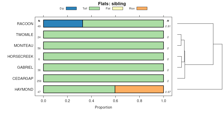
Racoon-Freeburg complex, 0 to 3 percent slopes, occasionally flooded | 74653 | 4517 | 2536291 | 2zcdb | mo055 | 2003 | 1:24000 |
Racoon-Freeburg complex, 1 to 3 percent slopes, occasionally flooded | 76034 | 665 | 2503155 | 2q2fc | mo055 | 2003 | 1:24000 |
Racoon-Freeburg complex, 0 to 3 percent slopes, occasionally flooded | 74653 | 4 | 2536292 | 2zcdb | mo065 | 1971 | 1:24000 |
Racoon-Freeburg complex, 1 to 3 percent slopes, occasionally flooded | 76034 | 1397 | 2688272 | 2q2fc | mo071 | 1986 | 1:24000 |
Freeburg silt loam, 1 to 3 percent slopes, rarely flooded | 67086 | 183 | 2575515 | 2r0db | mo071 | 1986 | 1:24000 |
Freeburg silt loam, 2 to 5 percent slopes | 64008 | 83 | 2533382 | 2qp7p | mo071 | 1986 | 1:24000 |
Fishpot-Urban land-Freeburg complex, 0 to 2 percent slopes, frequently flooded | 68001 | 63 | 2533763 | 2zhxw | mo071 | 1986 | 1:24000 |
Freeburg silt loam, 2 to 5 percent slopes, occasionally flooded | 64018 | 49 | 2533390 | 2qp7s | mo071 | 1986 | 1:24000 |
Racoon-Freeburg complex, 0 to 3 percent slopes, occasionally flooded | 74653 | 27 | 2536293 | 2zcdb | mo071 | 1986 | 1:24000 |
Freeburg silt loam, 0 to 3 percent slopes, rarely flooded | 64001 | 1644 | 2533346 | 2qp7j | mo073 | 1992 | 1:24000 |
Racoon-Freeburg complex, 0 to 3 percent slopes, occasionally flooded | 74653 | 50 | 2536294 | 2zcdb | mo073 | 1992 | 1:24000 |
Freeburg silt loam, 0 to 2 percent slopes, occasionally flooded | 64007 | 2104 | 2533373 | 2zhy3 | mo089 | 1975 | 1:24000 |
Freeburg silt loam, 1 to 3 percent slopes, occasionally flooded | 67030 | 280 | 2575440 | 2r0cc | mo089 | 1975 | 1:24000 |
Racoon-Freeburg complex, 0 to 3 percent slopes, occasionally flooded | 74653 | 3 | 2536295 | 2zcdb | mo093 | 1988 | 1:24000 |
Freeburg silt loam, 0 to 2 percent slopes, occasionally flooded | 64007 | 3352 | 2533377 | 2zhy3 | mo099 | 2000 | 1:24000 |
Freeburg silt loam, 2 to 5 percent slopes | 64008 | 3301 | 2533383 | 2qp7p | mo099 | 2000 | 1:24000 |
Freeburg silt loam, 5 to 9 percent slopes | 64009 | 1766 | 574242 | m8jy | mo099 | 2000 | 1:24000 |
Fishpot-Urban land-Freeburg complex, 0 to 2 percent slopes, frequently flooded | 68001 | 1628 | 3210761 | 2zhxw | mo099 | 2000 | 1:24000 |
Urban land-Freeburg complex, 2 to 5 percent slopes | 74676 | 861 | 574261 | m8kk | mo099 | 2000 | 1:24000 |
Freeburg silt loam, 1 to 3 percent slopes, occasionally flooded | 67030 | 192 | 2688245 | 2r0cc | mo099 | 2000 | 1:24000 |
Freeburg silt loam, 2 to 5 percent slopes, occasionally flooded | 64018 | 23 | 2533388 | 2qp7s | mo099 | 2000 | 1:24000 |
Fishpot-Urban land-Freeburg complex, 0 to 3 percent slopes | 68015 | 5 | 3210762 | 2zhxx | mo099 | 2000 | 1:24000 |
Freeburg silt loam, 0 to 3 percent slopes, rarely flooded | 64001 | 3674 | 2533343 | 2qp7j | mo101 | 1977 | 1:24000 |
Freeburg silt loam, 1 to 3 percent slopes, occasionally flooded | 67030 | 347 | 2579904 | 2r0cc | mo101 | 1977 | 1:24000 |
Freeburg silt loam, 0 to 2 percent slopes, occasionally flooded | 64007 | 88 | 2533372 | 2zhy3 | mo101 | 1977 | 1:24000 |
Freeburg silt loam, 0 to 3 percent slopes, rarely flooded | 64001 | 1635 | 2533347 | 2qp7j | mo125 | 2001 | 1:24000 |
Freeburg silt loam, 1 to 3 percent slopes, rarely flooded | 67086 | 408 | 2673212 | 2r0db | mo125 | 2001 | 1:24000 |
Freeburg silt loam, 0 to 2 percent slopes, occasionally flooded | 64007 | 1024 | 2533378 | 2zhy3 | mo131 | 2001 | 1:24000 |
Freeburg silt loam, 1 to 3 percent slopes | 64002 | 2 | 2533353 | 2qp7k | mo131 | 2001 | 1:24000 |
Freeburg silt loam, 0 to 2 percent slopes, occasionally flooded | 64007 | 77 | 2533370 | 2zhy3 | mo135 | 1962 | 1:24000 |
Freeburg silt loam, 1 to 3 percent slopes | 64002 | 55 | 2533354 | 2qp7k | mo135 | 1962 | 1:24000 |
Freeburg silt loam, 0 to 3 percent slopes, rarely flooded | 64001 | 31 | 2533348 | 2qp7j | mo135 | 1962 | 1:24000 |
Freeburg silt loam, 0 to 3 percent slopes, rarely flooded | 64001 | 3715 | 2533349 | 2qp7j | mo151 | 1996 | 1:24000 |
Freeburg silt loam, 3 to 8 percent slopes | 64003 | 1364 | 573535 | m7t4 | mo151 | 1996 | 1:24000 |
Freeburg silt loam, 1 to 3 percent slopes | 64002 | 1281 | 2533355 | 2qp7k | mo151 | 1996 | 1:24000 |
Freeburg silt loam, 0 to 3 percent slopes, rarely flooded | 64001 | 1591 | 2533350 | 2qp7j | mo157 | 1983 | 1:24000 |
Racoon-Freeburg complex, 0 to 3 percent slopes, occasionally flooded | 74653 | 4186 | 2536296 | 2zcdb | mo161 | 2001 | 1:24000 |
Racoon-Freeburg complex, 1 to 3 percent slopes, occasionally flooded | 76034 | 636 | 2673154 | 2q2fc | mo161 | 2001 | 1:24000 |
Racoon-Freeburg complex, 0 to 3 percent slopes, occasionally flooded | 74653 | 10 | 2536297 | 2zcdb | mo169 | 1984 | 1:24000 |
Fishpot-Urban land-Freeburg complex, 0 to 2 percent slopes, frequently flooded | 68001 | 4687 | 2533764 | 2zhxw | mo183 | 1979 | 1:24000 |
Freeburg silt loam, 0 to 3 percent slopes, rarely flooded | 64001 | 231 | 2533344 | 2qp7j | mo183 | 1979 | 1:24000 |
Freeburg silt loam, 1 to 3 percent slopes | 64002 | 1542 | 2533351 | 2qp7k | mo186 | 1982 | 1:24000 |
Fishpot-Urban land-Freeburg complex, 0 to 2 percent slopes, frequently flooded | 68001 | 11800 | 3210765 | 2zhxw | mo189 | 1979 | 1:24000 |
Fishpot-Urban land-Freeburg complex, 0 to 3 percent slopes | 68015 | 4980 | 3210764 | 2zhxx | mo189 | 1979 | 1:24000 |
Freeburg silt loam, 0 to 2 percent slopes, occasionally flooded | 64007 | 3310 | 2533374 | 2zhy3 | mo189 | 1979 | 1:24000 |
Freeburg silt loam, 2 to 5 percent slopes, occasionally flooded | 64018 | 2521 | 2533389 | 2qp7s | mo189 | 1979 | 1:24000 |
Racoon-Freeburg complex, 0 to 3 percent slopes, occasionally flooded | 74653 | 241 | 2536290 | 2zcdb | mo221 | 2003 | 1:24000 |