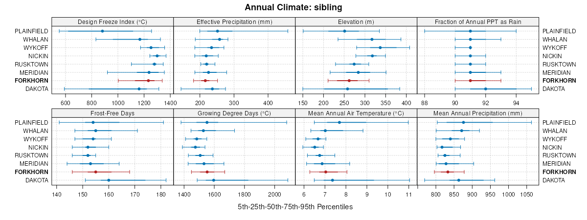
| Forkhorn sandy loam, 2 to 6 percent slopes | 433B | 421 | 2639465 | 1vgbl | wi011 | 1960 | 1:12000 |
Forkhorn sandy loam, 6 to 12 percent slopes, moderately eroded | 433C2 | 221 | 2561691 | 1vgbm | wi011 | 1960 | 1:12000 |
Forkhorn sandy loam, 0 to 3 percent slopes | 433A | 175 | 2639464 | 1vgbk | wi011 | 1960 | 1:12000 |
Forkhorn sandy loam, 12 to 20 percent slopes, moderately eroded | 433D2 | 47 | 2639466 | 1vgbn | wi011 | 1960 | 1:12000 |
Forkhorn sandy loam, 0 to 3 percent slopes | 433A | 88 | 2504040 | 1vgbk | wi023 | 1960 | 1:12000 |
Forkhorn sandy loam, 2 to 6 percent slopes | 433B | 73 | 2498540 | 1vgbl | wi023 | 1960 | 1:12000 |
Forkhorn sandy loam, 6 to 12 percent slopes, moderately eroded | 433C2 | 50 | 2504041 | 1vgbm | wi023 | 1960 | 1:12000 |
Forkhorn sandy loam, 2 to 6 percent slopes | 433B | 5161 | 2498541 | 1vgbl | wi033 | 2003 | 1:12000 |
Forkhorn sandy loam, 0 to 3 percent slopes | 433A | 5038 | 2504039 | 1vgbk | wi033 | 2003 | 1:12000 |
Forkhorn sandy loam, 6 to 12 percent slopes, moderately eroded | 433C2 | 573 | 2504042 | 1vgbm | wi033 | 2003 | 1:12000 |
Forkhorn sandy loam, 12 to 20 percent slopes, moderately eroded | 433D2 | 17 | 2518520 | 1vgbn | wi033 | 2003 | 1:12000 |
Forkhorn sandy loam, 2 to 6 percent slopes | 433B | 637 | 3099709 | 1vgbl | wi035 | 1974 | 1:12000 |
Forkhorn sandy loam, 6 to 12 percent slopes, moderately eroded | 433C2 | 214 | 3099710 | 1vgbm | wi035 | 1974 | 1:12000 |
Forkhorn sandy loam, 0 to 3 percent slopes | 433A | 126 | 3099708 | 1vgbk | wi035 | 1974 | 1:12000 |
Forkhorn sandy loam, 12 to 20 percent slopes, moderately eroded | 433D2 | 19 | 3099711 | 1vgbn | wi035 | 1974 | 1:12000 |
Forkhorn sandy loam, 2 to 6 percent slopes | 433B | 364 | 2774826 | 1vgbl | wi049 | 1960 | 1:20000 |
Forkhorn sandy loam, 6 to 12 percent slopes, moderately eroded | 433C2 | 255 | 2774827 | 1vgbm | wi049 | 1960 | 1:20000 |
Forkhorn sandy loam, 0 to 3 percent slopes | 433A | 203 | 2774825 | 1vgbk | wi049 | 1960 | 1:20000 |
Forkhorn sandy loam, 2 to 6 percent slopes | 433B | 24 | 2505893 | 1vgbl | wi053 | 1994 | 1:12000 |
Forkhorn sandy loam, 0 to 3 percent slopes | 433A | 342 | 2561498 | 1vgbk | wi057 | 1987 | 1:12000 |
Forkhorn sandy loam, 2 to 6 percent slopes | 433B | 154 | 2498542 | 1vgbl | wi063 | 2001 | 1:12000 |
Forkhorn sandy loam, 0 to 3 percent slopes | 433A | 181 | 2504038 | 1vgbk | wi091 | 1998 | 1:12000 |
Forkhorn sandy loam, 2 to 6 percent slopes | 433B | 126 | 2498543 | 1vgbl | wi091 | 1998 | 1:12000 |
Forkhorn sandy loam, 6 to 12 percent slopes, moderately eroded | 433C2 | 87 | 2504043 | 1vgbm | wi091 | 1998 | 1:12000 |
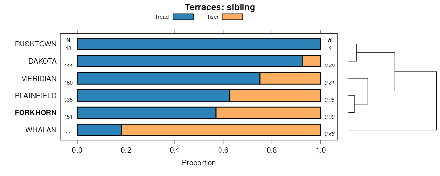
Forkhorn sandy loam, strath terrace, 1 to 6 percent slopes | 3431B | 1920 | 1699642 | 1v1m5 | wi093 | 2006 | 1:12000 |
Forkhorn sandy loam, 2 to 6 percent slopes | 433B | 623 | 1690954 | 1trkx | wi093 | 2006 | 1:12000 |
Forkhorn sandy loam, strath terrace, 6 to 12 percent slopes, moderately eroded | 3431C2 | 319 | 1699644 | 1v1m7 | wi093 | 2006 | 1:12000 |
Forkhorn sandy loam, strath terrace, 12 to 20 percent slopes, moderately eroded | 3431D2 | 247 | 1699641 | 1v1m4 | wi093 | 2006 | 1:12000 |
Forkhorn fine sandy loam, till plain, 1 to 6 percent slopes | 440B | 245 | 1700794 | 1v2tb | wi093 | 2006 | 1:12000 |
Forkhorn sandy loam, 0 to 3 percent slopes | 433A | 192 | 1690953 | 1trkw | wi093 | 2006 | 1:12000 |
Forkhorn sandy loam, 6 to 12 percent slopes, moderately eroded | 433C2 | 120 | 1690956 | 1trkz | wi093 | 2006 | 1:12000 |
Forkhorn sandy loam, strath terrace, 20 to 30 percent slopes | 3431E | 30 | 1699643 | 1v1m6 | wi093 | 2006 | 1:12000 |
Forkhorn sandy loam, 12 to 20 percent slopes, moderately eroded | 433D2 | 29 | 1690957 | 1trl0 | wi093 | 2006 | 1:12000 |
Forkhorn fine sandy loam, till plain, 6 to 12 percent slopes, moderately eroded | 440C2 | 5 | 1700795 | 1v2tc | wi093 | 2006 | 1:12000 |
Forkhorn sandy loam, 2 to 6 percent slopes | 433B | 201 | 2498545 | 1vgbl | wi103 | 2002 | 1:12000 |
Forkhorn sandy loam, 2 to 6 percent slopes | 433B | 1129 | 2683476 | 1vgbl | wi121 | 1969 | 1:12000 |
Forkhorn sandy loam, 0 to 3 percent slopes | 433A | 468 | 2683475 | 1vgbk | wi121 | 1969 | 1:12000 |
Forkhorn sandy loam, 6 to 12 percent slopes, moderately eroded | 433C2 | 201 | 2683477 | 1vgbm | wi121 | 1969 | 1:12000 |
Forkhorn sandy loam, 12 to 20 percent slopes, moderately eroded | 433D2 | 129 | 2683478 | 1vgbn | wi121 | 1969 | 1:12000 |
Forkhorn sandy loam, 6 to 12 percent slopes, moderately eroded | 433C2 | 46 | 2504044 | 1vgbm | wi123 | 1965 | 1:12000 |
Forkhorn sandy loam, 0 to 3 percent slopes | 433A | 38 | 3182197 | 1vgbk | wi141 | 1971 | 1:12000 |