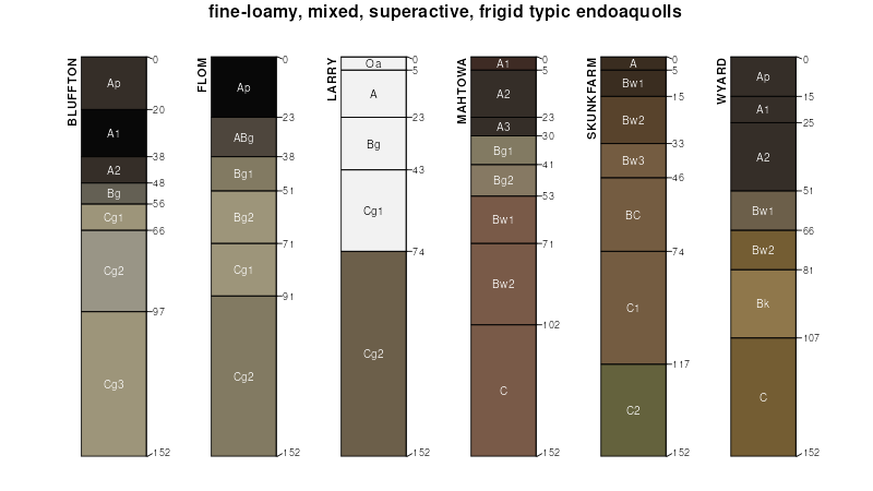
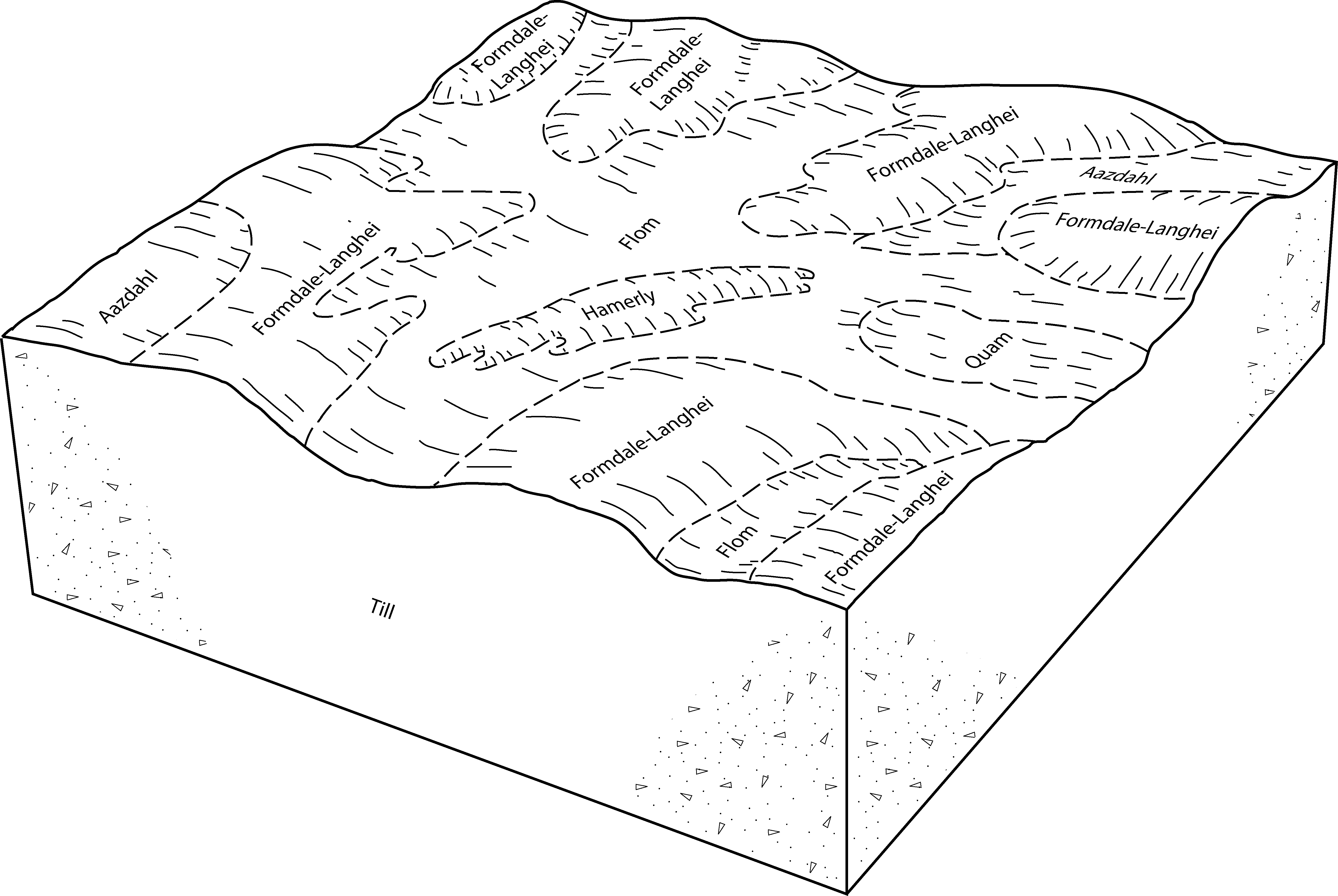
| Flom-Aazdahl-Hamerly complex, 0 to 2 percent slopes | J113A | 3020 | 3182503 | 2yw4z | mn005 | 1994 | 1:20000 |
Flom-Quam silty clay loams, 0 to 1 percent slopes, occasionally ponded | J116A | 1669 | 3182513 | 2yw5c | mn005 | 1994 | 1:20000 |
Flom-Hamerly complex, 0 to 2 percent slopes | J115A | 852 | 3182514 | 2yw5d | mn005 | 1994 | 1:20000 |
Aazdahl-Balaton-Flom complex, 0 to 3 percent slopes | J109A | 555 | 3182510 | 2yw58 | mn005 | 1994 | 1:20000 |
Flom-Aazdahl-Quam complex, 0 to 4 percent slopes | J114B | 362 | 3182511 | 2yw59 | mn005 | 1994 | 1:20000 |
Flom-Aazdahl-Hamerly complex, 0 to 2 percent slopes | J113A | 30489 | 3182521 | 2yw4z | mn011 | 1990 | 1:20000 |
Flom-Hamerly complex, 0 to 2 percent slopes | J115A | 5700 | 3182532 | 2yw5d | mn011 | 1990 | 1:20000 |
Aazdahl-Balaton-Flom complex, 0 to 3 percent slopes | J109A | 3236 | 3182528 | 2yw58 | mn011 | 1990 | 1:20000 |
Flom-Quam silty clay loams, 0 to 1 percent slopes, occasionally ponded | J116A | 1523 | 3182531 | 2yw5c | mn011 | 1990 | 1:20000 |
Flom-Aazdahl-Quam complex, 0 to 4 percent slopes | J114B | 560 | 3182529 | 2yw59 | mn011 | 1990 | 1:20000 |
Flom clay loam, 0 to 1 percent slopes | I683A | 226 | 2798121 | 2ql18 | mn027 | 1980 | 1:20000 |
Flom clay loam, very poorly drained, 0 to 1 percent slopes | I684A | 166 | 2798122 | 2ql19 | mn027 | 1980 | 1:20000 |
Flom-Aazdahl-Hamerly complex, 0 to 2 percent slopes | J113A | 18897 | 3182539 | 2yw4z | mn051 | 1974 | 1:20000 |
Flom-Hamerly complex, 0 to 2 percent slopes | J115A | 16625 | 3182550 | 2yw5d | mn051 | 1974 | 1:20000 |
Flom-Quam silty clay loams, 0 to 1 percent slopes, occasionally ponded | J116A | 4904 | 3182549 | 2yw5c | mn051 | 1974 | 1:20000 |
Aazdahl-Balaton-Flom complex, 0 to 3 percent slopes | J109A | 1558 | 3182546 | 2yw58 | mn051 | 1974 | 1:20000 |
Flom fine sandy loam, 0 to 1 percent slopes | I687A | 1430 | 2798209 | 2ql1b | mn051 | 1974 | 1:20000 |
Flom-Aazdahl-Quam complex, 0 to 4 percent slopes | J114B | 322 | 3182547 | 2yw59 | mn051 | 1974 | 1:20000 |
Flom clay loam | 36 | 1179 | 1859410 | 20dvz | mn101 | 2008 | 1:12000 |
Flom and Vallers soils, depressional | Fv | 2928 | 357228 | czqh | mn107 | 1970 | 1:20000 |
Flom clay loam, 0 to 1 percent slopes | I683A | 104 | 2799103 | 2ql18 | mn107 | 1970 | 1:20000 |
Flom-Aazdahl-Hamerly complex, 0 to 2 percent slopes | J113A | 4276 | 3182557 | 2yw4z | mn111 | 1996 | 1:20000 |
Flom-Hamerly complex, 0 to 2 percent slopes | J115A | 3877 | 3182568 | 2yw5d | mn111 | 1996 | 1:20000 |
Flom-Quam silty clay loams, 0 to 1 percent slopes, occasionally ponded | J116A | 2935 | 3182567 | 2yw5c | mn111 | 1996 | 1:20000 |
Flom-Aazdahl-Quam complex, 0 to 4 percent slopes | J114B | 660 | 3182565 | 2yw59 | mn111 | 1996 | 1:20000 |
Aazdahl-Balaton-Flom complex, 0 to 3 percent slopes | J109A | 359 | 3182564 | 2yw58 | mn111 | 1996 | 1:20000 |
Flom-Aazdahl-Hamerly complex, 0 to 2 percent slopes | J113A | 196 | 3182575 | 2yw4z | mn121 | 1968 | 1:20000 |
Flom-Quam silty clay loams, 0 to 1 percent slopes, occasionally ponded | J116A | 173 | 3182585 | 2yw5c | mn121 | 1968 | 1:20000 |
Flom-Hamerly complex, 0 to 2 percent slopes | J115A | 48 | 3182586 | 2yw5d | mn121 | 1968 | 1:20000 |
Flom-Aazdahl-Quam complex, 0 to 4 percent slopes | J114B | 26 | 3182583 | 2yw59 | mn121 | 1968 | 1:20000 |
Aazdahl-Balaton-Flom complex, 0 to 3 percent slopes | J109A | 25 | 3182582 | 2yw58 | mn121 | 1968 | 1:20000 |
Flom-Aazdahl-Hamerly complex, 0 to 2 percent slopes | J113A | 27021 | 3182593 | 2yw4z | mn149 | 1966 | 1:15840 |
Flom-Hamerly complex, 0 to 2 percent slopes | J115A | 16431 | 3182604 | 2yw5d | mn149 | 1966 | 1:15840 |
Flom-Quam silty clay loams, 0 to 1 percent slopes, occasionally ponded | J116A | 4422 | 3182603 | 2yw5c | mn149 | 1966 | 1:15840 |
Aazdahl-Balaton-Flom complex, 0 to 3 percent slopes | J109A | 3558 | 3182600 | 2yw58 | mn149 | 1966 | 1:15840 |
Flom-Aazdahl-Quam complex, 0 to 4 percent slopes | J114B | 315 | 3182601 | 2yw59 | mn149 | 1966 | 1:15840 |
Gonvick-Flom loams | 825 | 1121 | 428579 | gcz4 | mn153 | 1985 | 1:20000 |
Flom-Aazdahl-Hamerly complex, 0 to 2 percent slopes | J113A | 28830 | 3182611 | 2yw4z | mn155 | 1986 | 1:20000 |
Flom-Hamerly complex, 0 to 2 percent slopes | J115A | 9023 | 3182622 | 2yw5d | mn155 | 1986 | 1:20000 |
Aazdahl-Balaton-Flom complex, 0 to 3 percent slopes | J109A | 1713 | 3182618 | 2yw58 | mn155 | 1986 | 1:20000 |
Flom-Quam silty clay loams, 0 to 1 percent slopes, occasionally ponded | J116A | 809 | 3182621 | 2yw5c | mn155 | 1986 | 1:20000 |
Flom-Aazdahl-Quam complex, 0 to 4 percent slopes | J114B | 185 | 3182619 | 2yw59 | mn155 | 1986 | 1:20000 |
Flom clay loam, very poorly drained, 0 to 1 percent slopes | I684A | 8 | 2800447 | 2ql19 | mn167 | 1985 | 1:20000 |
Flom loam, 0 to 1 percent slopes | I322A | 277 | 2640919 | 1nywp | nd017 | 1983 | 1:20000 |
Flom loam, 0 to 1 percent slopes | I322A | 667 | 2641161 | 1nywp | nd077 | 2005 | 1:12000 |
Gilby-Flom loams, 0 to 2 percent slopes | I540A | 7396 | 2641422 | 2nb77 | nd091 | 1991 | 1:20000 |
Aastad-Flom complex | Aa | 1469 | 418129 | g131 | sd051 | 1977 | 1:20000 |
Flom clay loam | Fa | 1137 | 418146 | g13l | sd051 | 1977 | 1:20000 |
Flom loam, 0 to 1 percent slopes | I322A | 34 | 2800172 | 1nywp | sd109 | 1977 | 1:20000 |


