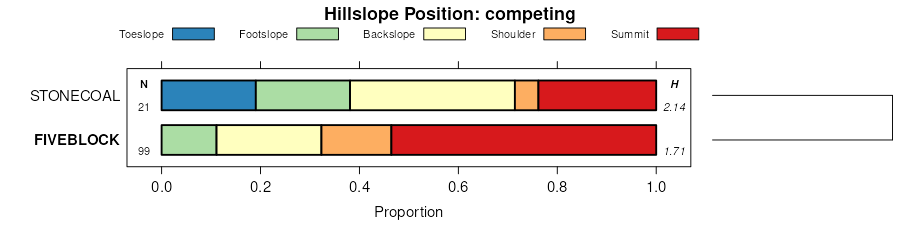
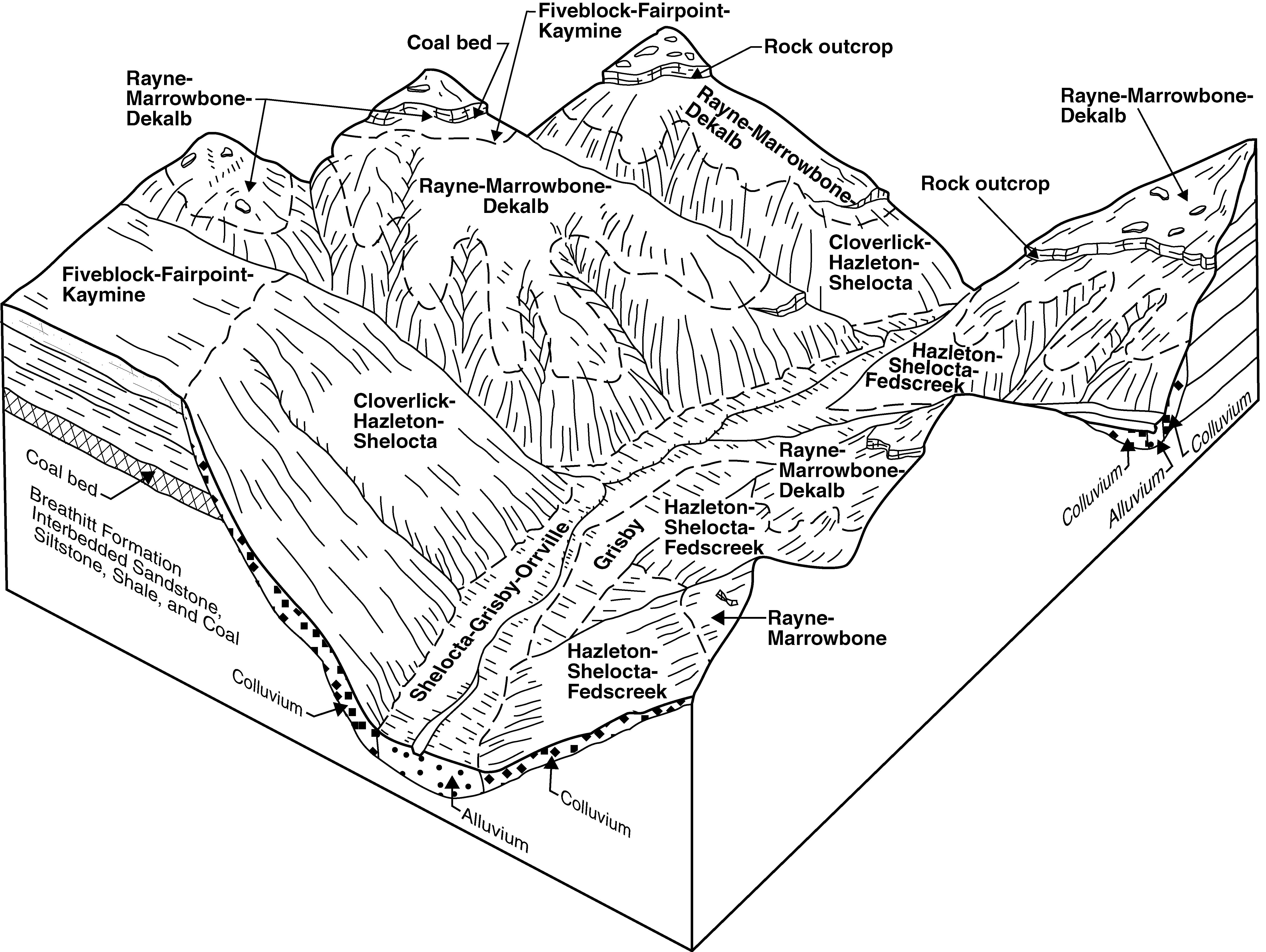
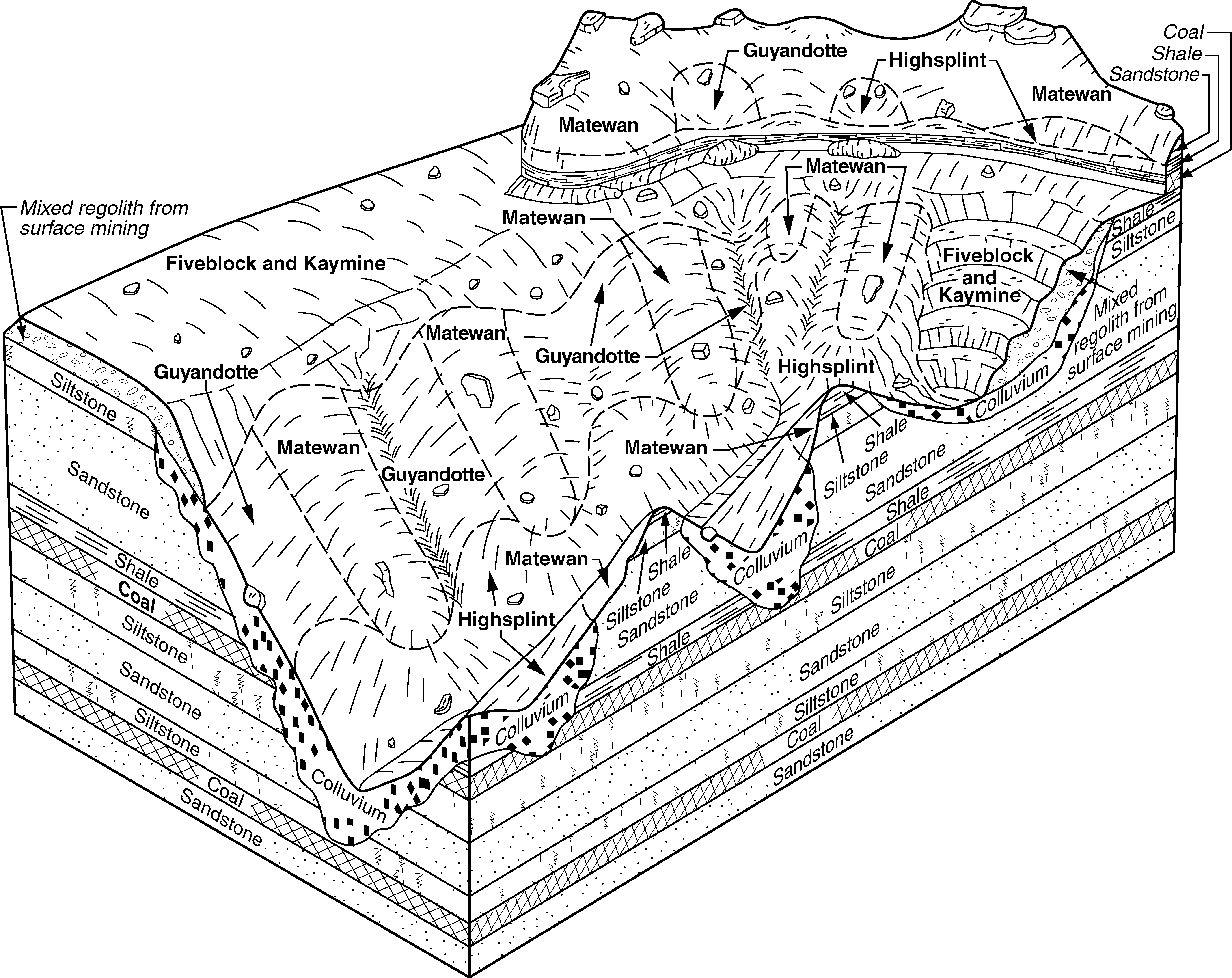
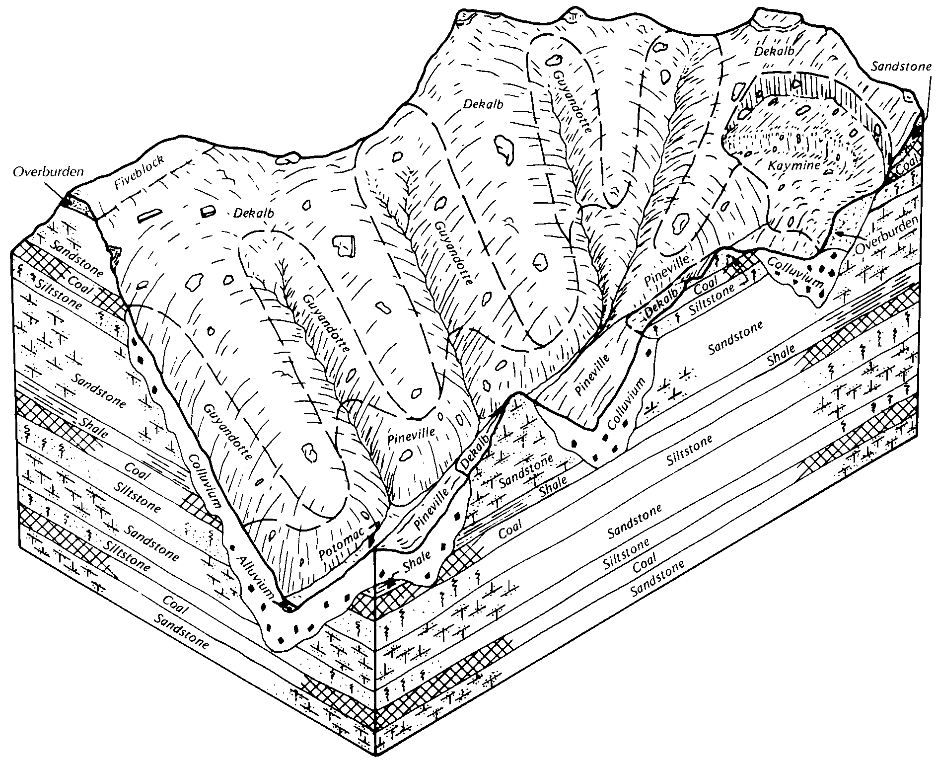
| Kaymine, Fairpoint, and Fiveblock soils, benched, 2 to 70 percent slopes, very stony | KfF | 51793 | 550742 | lh2w | ky626 | 1997 | 1:24000 |
Fiveblock and Kaymine soils, 0 to 30 percent slopes, stony | FkE | 10364 | 550731 | lh2j | ky626 | 1997 | 1:24000 |
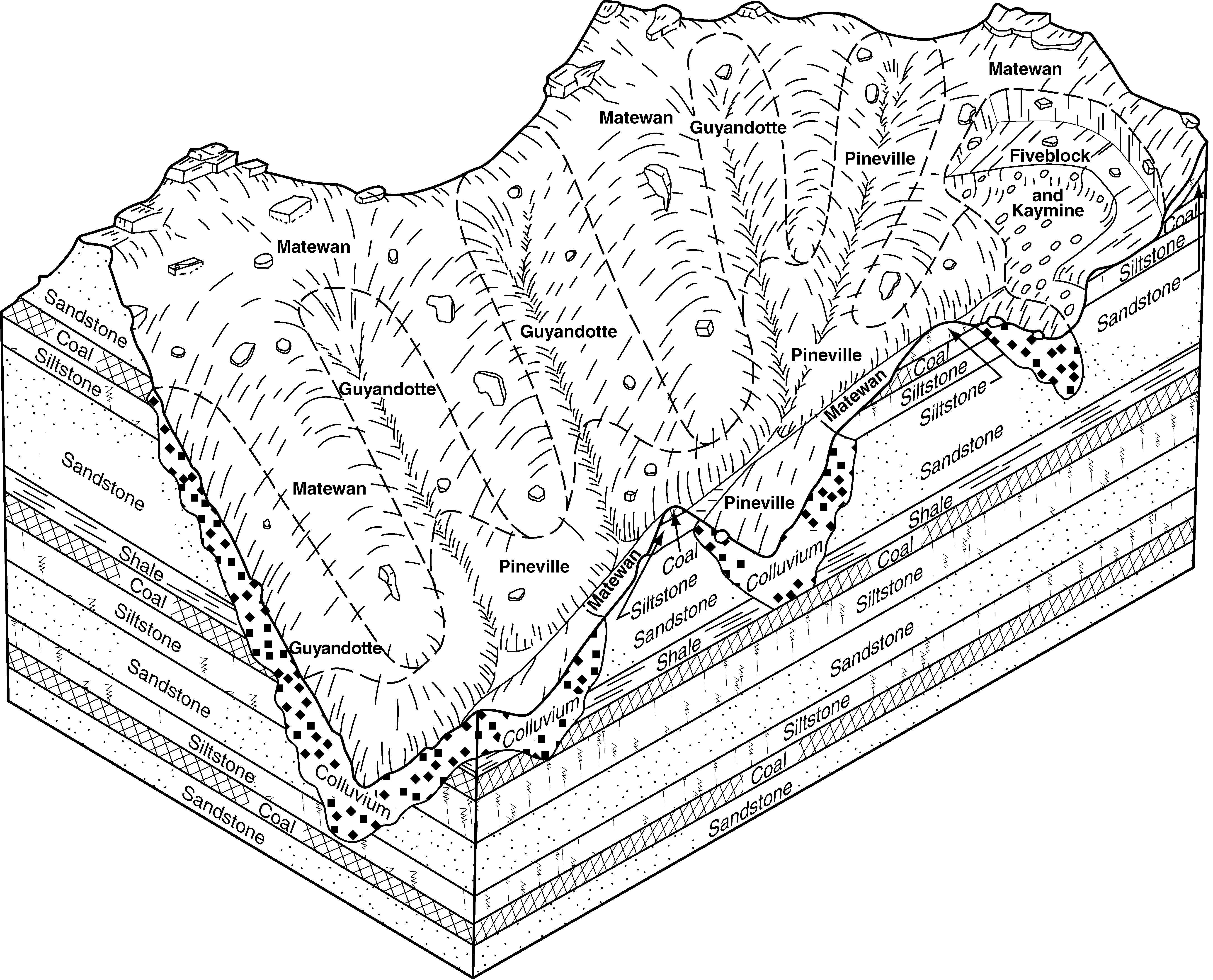
Fiveblock, Fairpoint, and Kaymine soils, 30 to 80 percent slopes, stony | FiF | 39182 | 550903 | lh82 | ky640 | 1996 | 1:24000 |
Fiveblock, Fairpoint, and Kaymine soils, 6 to 30 percent slopes, stony | FiD | 12417 | 550902 | lh81 | ky640 | 1996 | 1:24000 |
Fiveblock, Fairpoint, and Kaymine soils, 0 to 6 percent slopes, stony | FiB | 3697 | 550901 | lh80 | ky640 | 1996 | 1:24000 |
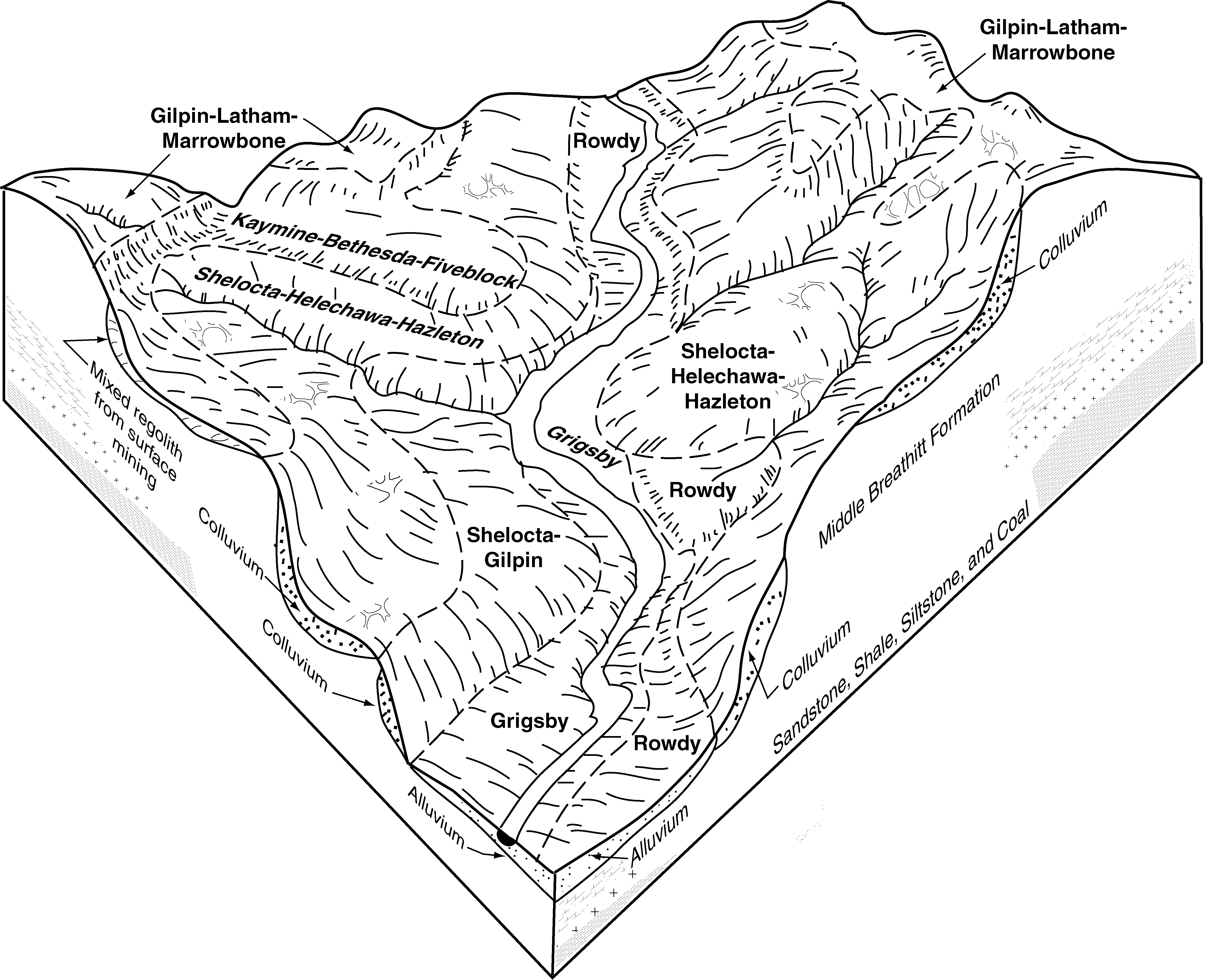
Kaymine, Bethesda, and Fiveblock soils, benched, 2 to 70 percent slopes, stony | KbF | 16828 | 550940 | lh98 | ky641 | 1994 | 1:24000 |
Kaymine, Bethesda, and Fiveblock soils, 0 to 20 percent slopes, stony | KbD | 3656 | 550939 | lh97 | ky641 | 1994 | 1:24000 |
Cedarcreek, Fiveblock, and Kaymine soils, 55 to 80 percent slopes, extremely stony | 3F | 12732 | 1670882 | 1t2pf | va027 | 2006 | 1:24000 |
Fiveblock-Sewell complex, 0 to 15 percent slopes, extremely stony | 8C | 1692 | 1670896 | 1t2pw | va027 | 2006 | 1:24000 |
Kaymine-Fiveblock-Cedarcreek complex, 0 to 15 percent slopes, extremely stony | 15C | 1681 | 1670954 | 1t2rr | va027 | 2006 | 1:24000 |
Kaymine-Fiveblock-Cedarcreek complex, 0 to 15 percent slopes, extremely stony | 16C | 3415 | 2399873 | 2lk88 | va051 | 2008 | 1:24000 |
Kaymine, Cedarcreek, and Fiveblock soils, 55 to 80 percent slopes, extremely stony | 15F | 3242 | 2399872 | 2lk87 | va051 | 2008 | 1:24000 |
Kaymine-Fiveblock-Cedarcreek complex, 0 to 15 percent slopes, extremely stony | 34C | 2029 | 1671897 | 1t3r5 | va167 | 2006 | 1:24000 |
Kaymine-Fiveblock complex, 55 to 80 percent slopes, extremely stony | 33F | 808 | 1671900 | 1t3r8 | va167 | 2006 | 1:24000 |
Kaymine and Fiveblock soils, 55 to 80 percent slopes, extremely stony | 39G | 16768 | 2508565 | 2q7qg | va195 | 2010 | 1:24000 |
Kaymine-Fiveblock-Cedarcreek complex, 0 to 15 percent slopes, extremely stony | 42C | 7295 | 2508568 | 2q7qj | va195 | 2010 | 1:24000 |
Kaymine-Fiveblock-Rock outcrop complex, 0 to 15 percent slopes, very stony | 43C | 5415 | 2508569 | 2q7qk | va195 | 2010 | 1:24000 |
Fiveblock very channery sandy loam, very steep, extremely stony | FvF | 1295 | 514856 | k8r8 | wv005 | 1988 | 1:24000 |
Cedarcreek and Fiveblock soils, 25 to 75 percent slopes, very stony, reclaimed | CfF | 6472 | 3054888 | 2xph3 | wv039 | 1976 | 1:20000 |
Cedarcreek and Fiveblock soils, 8 to 25 percent slopes, very stony, reclaimed | CfD | 4409 | 3054887 | 2xph2 | wv039 | 1976 | 1:20000 |
Cedarcreek and Fiveblock soils, 0 to 8 percent slopes, very stony, reclaimed | CfB | 3077 | 3054886 | 2xph1 | wv039 | 1976 | 1:20000 |
Cedarcreek and Fiveblock soils, 25 to 75 percent slopes, very stony, unreclaimed | CcF | 1837 | 3054873 | 2xb0l | wv039 | 1976 | 1:20000 |
Cedarcreek and Fiveblock soils, 25 to 75 percent slopes, very stony, unreclaimed, highwall | ChF | 1335 | 3054879 | 2xpgw | wv039 | 1976 | 1:20000 |
Cedarcreek and Fiveblock soils, 8 to 25 percent slopes, very stony, reclaimed, highwall | CkD | 496 | 3054882 | 2xpgz | wv039 | 1976 | 1:20000 |
Cedarcreek and Fiveblock soils, 25 to 75 percent slopes, very stony, reclaimed, highwall | CkF | 381 | 3054883 | 2xph0 | wv039 | 1976 | 1:20000 |
Cedarcreek and Fiveblock soils, 8 to 25 percent slopes, very stony, unreclaimed | CcD | 217 | 3054872 | 2xpgt | wv039 | 1976 | 1:20000 |
Cedarcreek and Fiveblock soils, 8 to 25 percent slopes, very stony, unreclaimed, highwall | ChD | 143 | 3054878 | 2xpgy | wv039 | 1976 | 1:20000 |
Cedarcreek and Fiveblock soils, 0 to 8 percent slopes, very stony, unreclaimed | CcB | 48 | 3054871 | 2xpgv | wv039 | 1976 | 1:20000 |
Kaymine and Fiveblock soils, 35 to 65 percent slopes, extremely stony | KfF | 1921 | 553374 | lkts | wv043 | 2005 | 1:24000 |
Kaymine and Fiveblock soils, 0 to 8 percent slopes, extremely stony | KfB | 606 | 553375 | lktt | wv043 | 2005 | 1:24000 |
Cedarcreek and Fiveblock soils, 25 to 75 percent slopes, very stony, unreclaimed, highwall | ChF | 509 | 3054898 | 2xpgw | wv079 | 1981 | 1:20000 |
Cedarcreek and Fiveblock soils, 8 to 25 percent slopes, very stony, unreclaimed | CcD | 186 | 3054893 | 2xpgt | wv079 | 1981 | 1:20000 |
Cedarcreek and Fiveblock soils, 8 to 25 percent slopes, very stony, unreclaimed, highwall | ChD | 113 | 3054897 | 2xpgy | wv079 | 1981 | 1:20000 |
Cedarcreek and Fiveblock soils, 25 to 75 percent slopes, very stony, unreclaimed | CcF | 93 | 3054894 | 2xb0l | wv079 | 1981 | 1:20000 |
Cedarcreek and Fiveblock soils, 8 to 25 percent slopes, very stony, reclaimed | CfD | 47 | 3054900 | 2xph2 | wv079 | 1981 | 1:20000 |
Cedarcreek and Fiveblock soils, 0 to 8 percent slopes, very stony, reclaimed | CfB | 8 | 3054899 | 2xph1 | wv079 | 1981 | 1:20000 |
Cedarcreek and Fiveblock soils, 0 to 8 percent slopes, very stony, unreclaimed | CcB | 5 | 3054892 | 2xpgv | wv079 | 1981 | 1:20000 |
Fiveblock channery sandy loam, very steep, very stony | FvF | 1520 | 515012 | k8x9 | wv099 | 1993 | 1:24000 |
Fiveblock channery sandy loam, steep | FvE | 605 | 513494 | k7bb | wv109 | 1984 | 1:24000 |
Fiveblock and Kaymine soils, 35 to 80 percent slopes, extremely stony | FkF | 17385 | 1155540 | 17sfh | wv620 | 2005 | 1:24000 |
Fiveblock and Kaymine soils, 0 to 15 percent slopes, extremely stony | FkC | 4235 | 1155539 | 17sfg | wv620 | 2005 | 1:24000 |
Kaymine and Fiveblock soils, 35 to 65 percent slopes, extremely stony | KfF | 75 | 1155549 | 17sfs | wv620 | 2005 | 1:24000 |
Kaymine and Fiveblock soils, 0 to 8 percent slopes, extremely stony | KfB | 20 | 1155548 | 17sfr | wv620 | 2005 | 1:24000 |
Fiveblock very channery sandy loam, very steep, extremely stony | FvF | 1217 | 2462223 | 2nn4k | wv705 | 2009 | 1:24000 |
Fiveblock channery sandy loam, very steep, extremely stony | FvF | 1455 | 2512853 | k7lc | wv767 | 2011 | 1:20000 |
Fiveblock channery sandy loam, 3 to 8 percent slopes, extremely stony | FvB | 899 | 2512852 | k7lb | wv767 | 2011 | 1:20000 |


