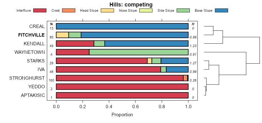
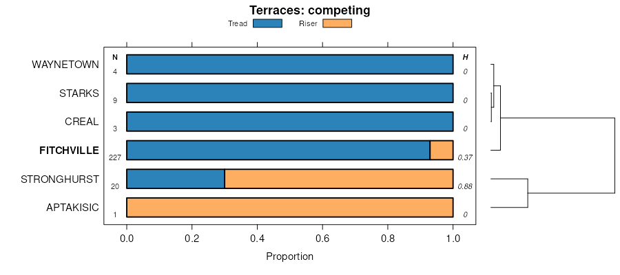
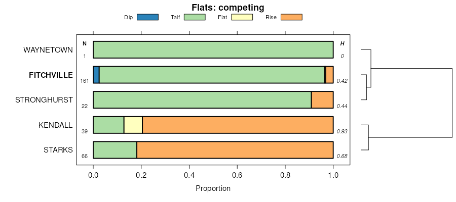
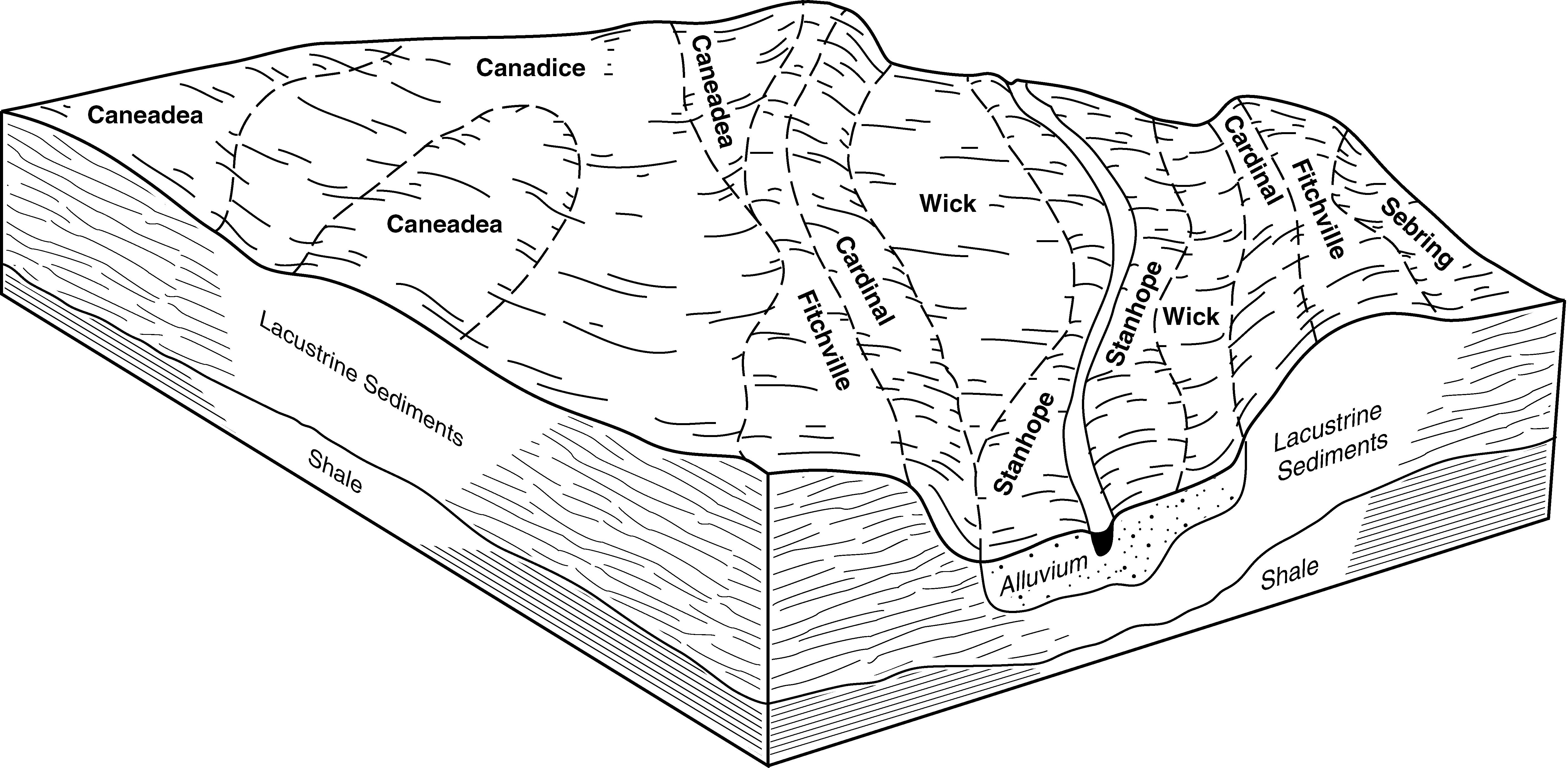
| Fitchville silt loam, 1 to 4 percent slopes | FcA | 2327 | 288159 | 2vww4 | oh005 | 1976 | 1:15840 |
Fitchville silt loam, 0 to 2 percent slopes | FbA | 77 | 1592608 | 2vwvp | oh005 | 1976 | 1:15840 |
Fitchville silt loam, 2 to 6 percent slopes | FbB | 6 | 1592609 | 2vww5 | oh005 | 1976 | 1:15840 |
Fitchville silt loam, gravelly subsoil, 0 to 2 percent slopes | FgA | 1 | 1592776 | 2vww7 | oh005 | 1976 | 1:15840 |
Fitchville silt loam, 0 to 2 percent slopes | FcA | 3650 | 298889 | 2vwvp | oh007 | 2001 | 1:12000 |
Fitchville silt loam, 2 to 6 percent slopes | FcB | 1652 | 298890 | 2vww5 | oh007 | 2001 | 1:12000 |
Fitchville silt loam, 0 to 3 percent slopes | FcA | 980 | 537359 | 2s5h2 | oh009 | 1981 | 1:15840 |
Fitchville silt loam, 0 to 3 percent slopes | FtA | 115 | 537091 | 2s5h2 | oh013 | 1978 | 1:15840 |
Fitchville silt loam, 2 to 6 percent slopes | FhB | 1 | 1585745 | 1q732 | oh015 | 1987 | 1:15840 |
Fitchville silt loam, 3 to 8 percent slopes | FcB | 3462 | 537984 | 2tqpn | oh019 | 1981 | 1:15840 |
Fitchville silt loam, 0 to 3 percent slopes | FcA | 2069 | 537983 | 2s5h2 | oh019 | 1981 | 1:15840 |
Fitchville silt loam, 2 to 6 percent slopes | FbB | 69 | 1670711 | 1t2hx | oh019 | 1981 | 1:15840 |
Fitchville silt loam, 0 to 2 percent slopes | FbA | 17 | 1670019 | 1t1sl | oh019 | 1981 | 1:15840 |
Fitchville silt loam, 6 to 12 percent slopes | FbC | 3 | 1670712 | 1t2hy | oh019 | 1981 | 1:15840 |
Fitchville silt loam, 0 to 2 percent slopes | FdA | 998 | 298764 | 2vwvp | oh029 | 2005 | 1:12000 |
Fitchville silt loam, 2 to 6 percent slopes | FdB | 869 | 298765 | 2vww5 | oh029 | 2005 | 1:12000 |
Fitchville silt loam, 0 to 3 percent slopes | FhA | 2661 | 536634 | 2s5h2 | oh031 | 1996 | 1:15840 |
Fitchville silt loam, 3 to 8 percent slopes | FhB | 1626 | 536635 | 2tqpn | oh031 | 1996 | 1:15840 |
Fitchville silt loam, 0 to 2 percent slopes | FcA | 1266 | 168561 | 5ndg | oh033 | 1975 | 1:15840 |
Fitchville silt loam, 2 to 6 percent slopes | FcB | 215 | 168562 | 5ndh | oh033 | 1975 | 1:15840 |
Bennington-Fitchville silt loams, 2 to 6 percent slopes | BkB | 9 | 1019359 | 136qk | oh033 | 1975 | 1:15840 |
Fitchville silt loam, 0 to 2 percent slopes | FcA | 2296 | 287302 | 2vwvp | oh035 | 1978 | 1:15840 |
Fitchville silt loam, 2 to 6 percent slopes | FcB | 705 | 287303 | 2vww5 | oh035 | 1978 | 1:15840 |
Fitchville silt loam, 0 to 2 percent slopes | FbA | 1559 | 172248 | 5s7d | oh045 | 1998 | 1:12000 |
Fitchville silt loam, 0 to 2 percent slopes | FcA | 2078 | 287554 | 2vwvp | oh055 | 1979 | 1:15840 |
Fitchville silt loam, 2 to 6 percent slopes | FcB | 1002 | 287555 | 2vww5 | oh055 | 1979 | 1:15840 |
Fitchville silt loam, 0 to 3 percent slopes | FtA | 537 | 536902 | 2s5h2 | oh059 | 1998 | 1:15840 |
Fitchville silt loam, 0 to 3 percent slopes | FcA | 1726 | 536733 | 2s5h2 | oh067 | 1993 | 1:15840 |
Fitchville silt loam, 3 to 8 percent slopes | FcB | 1442 | 536734 | 2tqpn | oh067 | 1993 | 1:15840 |
Fitchville silt loam, 0 to 2 percent slopes | FcA | 535 | 1420410 | 1jp1p | oh071 | 1973 | 1:15840 |
Fitchville silt loam, 2 to 6 percent slopes | FcB | 446 | 1420411 | 1jp1q | oh071 | 1973 | 1:15840 |
Fitchville silt loam, 2 to 6 percent slopes | FhB | 2790 | 286903 | 2vww5 | oh075 | 1989 | 1:15840 |
Fitchville silt loam, 0 to 2 percent slopes | FhA | 2395 | 286902 | 2vwvp | oh075 | 1989 | 1:15840 |
Fitchville silt loam, 0 to 2 percent slopes | FcA | 5 | 1605964 | 1qx49 | oh077 | 1988 | 1:15840 |
Fitchville silt loam, 0 to 2 percent slopes | FcA | 5438 | 613579 | nlgw | oh083 | 1983 | 1:15840 |
Fitchville silt loam, 2 to 6 percent slopes | FcB | 3018 | 613580 | nlgx | oh083 | 1983 | 1:15840 |
Fitchville silt loam, 1 to 4 percent slopes | FcA | 1067 | 286813 | 2vww4 | oh085 | 1976 | 1:15840 |
Fitchville silt loam, 0 to 2 percent slopes | FcA | 3755 | 171025 | 5qyy | oh089 | 1986 | 1:15840 |
Fitchville silt loam, 2 to 6 percent slopes | FcB | 220 | 171026 | 5qyz | oh089 | 1986 | 1:15840 |
Fitchville silt loam, 0 to 2 percent slopes | FcA | 7003 | 287759 | 2vwvp | oh093 | 1972 | 1:15840 |
Fitchville silt loam, low terrace, 0 to 2 percent slopes | FdA | 3300 | 287761 | 9nfm | oh093 | 1972 | 1:15840 |
Fitchville-Urban land complex, 0 to 2 percent slopes | FeA | 2130 | 287762 | 2vww1 | oh093 | 1972 | 1:15840 |
Fitchville silt loam, 2 to 6 percent slopes | FcB | 243 | 287760 | 2vww5 | oh093 | 1972 | 1:15840 |
Fitchville silt loam, 2 to 6 percent slopes | FcB | 2478 | 816760 | 2vww5 | oh099 | 1966 | 1:15840 |
Fitchville silt loam, 0 to 2 percent slopes | FcA | 940 | 816759 | 2vwvp | oh099 | 1966 | 1:15840 |
Fitchville silt loam, till substratum, 2 to 6 percent slopes | FhB | 814 | 816761 | wdx4 | oh099 | 1966 | 1:15840 |
Fitchville-Urban land complex, 2 to 6 percent slopes | FlB | 324 | 816762 | 2vww6 | oh099 | 1966 | 1:15840 |
Fitchville silt loam, 0 to 3 percent slopes | FcA | 574 | 171189 | 5r47 | oh101 | 1984 | 1:15840 |
Fitchville silt loam, 0 to 2 percent slopes | FcA | 4269 | 288344 | 2vwvp | oh103 | 1974 | 1:15840 |
Fitchville silt loam, 2 to 6 percent slopes | FcB | 1772 | 288345 | 2vww5 | oh103 | 1974 | 1:15840 |
Fitchville silt loam, low terrace, 0 to 2 percent slopes | FlA | 1551 | 288346 | 9p1h | oh103 | 1974 | 1:15840 |
Fitchville silt loam, 0 to 3 percent slopes | FcA | 3611 | 537885 | 2s5h2 | oh119 | 1989 | 1:15840 |
Fitchville silt loam, 3 to 8 percent slopes | FcB | 1598 | 537886 | 2tqpn | oh119 | 1989 | 1:15840 |
Fitchville silt loam, 0 to 3 percent slopes | FtA | 1149 | 537532 | l1br | oh127 | 1984 | 1:15840 |
Fitchville silt loam, 0 to 2 percent slopes | FdA | 4 | 1541661 | 1nr70 | oh127 | 1984 | 1:15840 |
Fitchville silt loam, 0 to 2 percent slopes | FcA | 3053 | 288445 | 2vwvp | oh133 | 1973 | 1:15840 |
Fitchville silt loam, 2 to 6 percent slopes | FcB | 1710 | 288446 | 2vww5 | oh133 | 1973 | 1:15840 |
Fitchville-Urban land complex, 0 to 2 percent slopes | FnA | 316 | 288447 | 2vww1 | oh133 | 1973 | 1:15840 |
Fitchville silt loam, 0 to 2 percent slopes | FcA | 2565 | 170750 | 2vwvp | oh139 | 1971 | 1:15840 |
Fitchville-Bennington silt loams, 0 to 2 percent slopes | FdA | 1243 | 170752 | 5qp4 | oh139 | 1971 | 1:15840 |
Fitchville silt loam, 2 to 6 percent slopes | FcB | 802 | 170751 | 2vww5 | oh139 | 1971 | 1:15840 |
Fitchville silt loam, gravelly subsoil, 0 to 2 percent slopes | FgA | 759 | 170753 | 2vww7 | oh139 | 1971 | 1:15840 |
Bennington-Fitchville silt loams, 2 to 6 percent slopes | BpB | 328 | 170721 | 5qn4 | oh139 | 1971 | 1:15840 |
Fitchville silt loam, gravelly subsoil, 2 to 6 percent slopes | FgB | 295 | 170754 | 2vww8 | oh139 | 1971 | 1:15840 |
Fitchville silt loam, 1 to 4 percent slopes | FbA | 3 | 1406552 | 2vww4 | oh139 | 1971 | 1:15840 |
Fitchville silt loam, 0 to 2 percent slopes | FhA | 3001 | 170871 | 5qsz | oh141 | 1997 | 1:15840 |
Fitchville silt loam, 2 to 6 percent slopes | FhB | 425 | 170872 | 5qt0 | oh141 | 1997 | 1:15840 |
Fitchville silt loam, 0 to 3 percent slopes | FcA | 1940 | 537246 | 2s5h2 | oh145 | 1984 | 1:15840 |
Fitchville silt loam, 1 to 4 percent slopes | FcA | 1536 | 169975 | 5pw2 | oh147 | 1978 | 1:15840 |
Fitchville silt loam, 0 to 2 percent slopes | FbA | 9 | 1592213 | 1qftq | oh147 | 1978 | 1:15840 |
Fitchville silt loam, 0 to 2 percent slopes | FcA | 9345 | 287993 | 2vwvp | oh151 | 1967 | 1:15840 |
Fitchville silt loam, 2 to 6 percent slopes | FcB | 3181 | 287994 | 2vww5 | oh151 | 1967 | 1:15840 |
Fitchville-Urban land complex, 0 to 6 percent slopes | Fu | 412 | 287996 | 2vww3 | oh151 | 1967 | 1:15840 |
Fitchville silt loam, 6 to 12 percent slopes | FcC | 244 | 287995 | 9np5 | oh151 | 1967 | 1:15840 |
Fitchville silt loam, 0 to 2 percent slopes | FcA | 2981 | 825345 | 2vwvp | oh153 | 1969 | 1:20000 |
Fitchville silt loam, 2 to 6 percent slopes | FcB | 1861 | 825346 | 2vww5 | oh153 | 1969 | 1:20000 |
Fitchville-Urban land complex, 0 to 2 percent slopes | Fn | 1082 | 825347 | 2vww1 | oh153 | 1969 | 1:20000 |
Fitchville silt loam, low terrace, 0 to 2 percent slopes | FlA | 2 | 1474194 | 1lh0n | oh153 | 1969 | 1:20000 |
Fitchville silt loam, 0 to 2 percent slopes | FcA | 14325 | 287039 | 2vwvp | oh155 | 1986 | 1:15840 |
Fitchville silt loam, 2 to 6 percent slopes | FcB | 2800 | 287040 | 2vww5 | oh155 | 1986 | 1:15840 |
Fitchville-Urban land complex, 0 to 3 percent slopes | FdA | 2385 | 287041 | 2vww2 | oh155 | 1986 | 1:15840 |
Fitchville silt loam, 0 to 3 percent slopes | FcA | 17257 | 536304 | 2s5h2 | oh157 | 1981 | 1:15840 |
Fitchville silt loam, 3 to 8 percent slopes | FcB | 11703 | 536305 | 2tqpn | oh157 | 1981 | 1:15840 |
Fitchville-Urban land complex, undulating | FeB | 1550 | 536308 | l028 | oh157 | 1981 | 1:15840 |
Fitchville silt loam, 0 to 2 percent slopes | FbA | 1317 | 1589410 | 1qbx9 | oh157 | 1981 | 1:15840 |
Fitchville silt loam, clayey substratum, 3 to 8 percent slopes | FdB | 750 | 536307 | l027 | oh157 | 1981 | 1:15840 |
Fitchville silt loam, 2 to 6 percent slopes | FbB | 346 | 1589411 | 1qbxb | oh157 | 1981 | 1:15840 |
Fitchville silt loam, clayey substratum, 0 to 3 percent slopes | FdA | 270 | 536306 | l026 | oh157 | 1981 | 1:15840 |
Fitchville silt loam, 0 to 3 percent slopes | FcA | 832 | 536379 | 2s5h2 | oh163 | 1998 | 1:15840 |
Fitchville silt loam, 0 to 2 percent slopes | FcA | 7565 | 287191 | 2vwvp | oh169 | 1981 | 1:15840 |
Fitchville silt loam, 2 to 6 percent slopes | FcB | 6981 | 287192 | 2vww5 | oh169 | 1981 | 1:15840 |
Fitchville-Urban land complex, 0 to 2 percent slopes | FfA | 833 | 287193 | 2vww1 | oh169 | 1981 | 1:15840 |
Fitchville silt loam, 0 to 2 percent slopes | FcA | 2119 | 169609 | 5ph8 | oh175 | 1980 | 1:15840 |
Fitchville silt loam, 2 to 6 percent slopes | FcB | 922 | 169610 | 5ph9 | oh175 | 1980 | 1:15840 |
Fitchville silt loam, 0 to 2 percent slopes | FcA | 2 | 2900340 | 2vwvp | pa007 | 1978 | 1:15840 |
Fitchville silt loam, 0 to 2 percent slopes | FcA | 1271 | 2633061 | 2vwvp | pa049 | 2012 | 1:12000 |
Fitchville silt loam, 2 to 6 percent slopes | FcB | 1088 | 2633062 | 2vww5 | pa049 | 2012 | 1:12000 |