| Finn and Tepete families, 0 to 15 percent slopes | 101A | 34570 | 509255 | k2xl | co647 | | 1:24000 |
Frisco family, very stony-Finn family, very stony-Water complex, 0 to 20 percent slopes | 666A | 26650 | 509375 | k31g | co647 | | 1:24000 |
Frisco family, very stony-Finn family, very stony-Water complex, 0 to 20 percent slopes | 666A | 7910 | 3176977 | k31g | co650 | | 1:24000 |
Leighcan, very stony-Finn families, complex, 1 to 60% slopes | 607C | 4554 | 507547 | k14h | co650 | | 1:24000 |
Finn and Tepete families, 0 to 15 percent slopes | 101A | 3399 | 3176972 | k2xl | co650 | | 1:24000 |
Finn, occasionally ponded-Histic Cryaquepts family, frequently ponded, complex, 0 to 2 percent slopes | 12102 | 623 | 3173428 | 2yy56 | id703 | | 1:24000 |
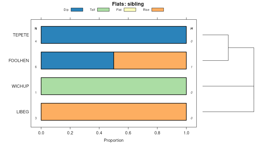
Foolhen, rarely flooded-Bearmouth-Finn, frequently flooded families, complex, valley bottoms | 644G | 6384 | 148848 | 4zwk | mt605 | 2007 | 1:24000 |
Libeg-Finn, frequently flooded-Sebud families, complex, alluvial-colluvial deposits | 617G | 5447 | 149131 | 505p | mt605 | 2007 | 1:24000 |
Rooset-Woodhurst-Tiban families, complex, gentle mountain slopes | 523E | 4864 | 149210 | 5087 | mt605 | 2007 | 1:24000 |
Finn, frequently flooded-Wander-Foolhen, rarely flooded families, complex, valley bottoms | 647G | 4640 | 149133 | 505r | mt605 | 2007 | 1:24000 |
Wetopa-Finn, frequently flooded-Wichup, rarely flooded families, complex, valley bottoms | 642G | 1286 | 149011 | 501t | mt605 | 2007 | 1:24000 |
Libeg-Finn, frequently flooded-Sebud families, complex, ice-margin slopes | 467G | 1074 | 149121 | 505c | mt605 | 2007 | 1:24000 |
Wetopa-Finn, frequently flooded-Wichup, rarely flooded families, complex, alluvial-colluvial deposits | 612G | 1009 | 148721 | 4zrg | mt605 | 2007 | 1:24000 |
Wetopa-Philipsburg-Prudy families, complex, gentle mountain slopes | 523C | 355 | 149229 | 508v | mt605 | 2007 | 1:24000 |
Bearmouth-Mooseflat-Finn complex, 0 to 4 percent slopes | 9B | 188 | 1859513 | 20dz9 | mt605 | 2007 | 1:24000 |
Finn-Water complex, 0 to 4 percent slopes | 776B | 53 | 1859588 | 20f1q | mt605 | 2007 | 1:24000 |
Finn loam, 0 to 4 percent slopes | 676B | 39 | 1859583 | 20f1k | mt605 | 2007 | 1:24000 |
Foolhen-Finn complex, 0 to 4 percent slopes, frequently flooded | 72B | 8 | 2403831 | 2lpcy | mt605 | 2007 | 1:24000 |
Finn-Slagamelt-Hairpin, stony complex, 0 to 8 percent slopes | 243C | 5 | 2403837 | 2lpd4 | mt605 | 2007 | 1:24000 |
Bearmouth-Mooseflat-Finn complex, 0 to 4 percent slopes | 9B | 3507 | 806446 | w25d | mt610 | 2005 | 1:24000 |
Libeg-Finn-Sebud families, complex, alluvial-colluvial deposits | 617G | 524 | 1531233 | 1ndcm | mt610 | 2005 | 1:24000 |
Finn-Wander-Foolhen families, complex, valley bottoms | 647G | 118 | 1531245 | 1ndd0 | mt610 | 2005 | 1:24000 |
Foolhen-Finn complex, 0 to 4 percent slopes, frequently flooded | 72B | 1848 | 1868613 | 20qfv | mt612 | 2011 | 1:24000 |
Finn-Slagamelt-Hairpin, stony complex, 0 to 8 percent slopes | 243C | 1617 | 1860657 | 20g56 | mt612 | 2011 | 1:24000 |
Tibson-Finn complex, 2 to 25 percent slopes | 94E | 657 | 2383943 | 2l0pd | mt612 | 2011 | 1:24000 |
Copperbasin, rarely flooded-Finn-Mooseflat, occasionally flooded complex, 1 to 4 percent slopes | 280B | 273 | 2515392 | 2ppjl | mt612 | 2011 | 1:24000 |
Finn, frequently flooded-Wander-Foolhen, rarely flooded families, complex, valley bottoms | 647G | 135 | 2597762 | 505r | mt612 | 2011 | 1:24000 |
Foolhen, rarely flooded-Bearmouth-Finn, frequently flooded families, complex, valley bottoms | 644G | 106 | 2597748 | 4zwk | mt612 | 2011 | 1:24000 |
Libeg-Finn, frequently flooded-Sebud families, complex, alluvial-colluvial deposits | 617G | 64 | 2597761 | 505p | mt612 | 2011 | 1:24000 |
Wetopa-Finn, frequently flooded-Wichup, rarely flooded families, complex, valley bottoms | 642G | 1 | 2511827 | 501t | mt612 | 2011 | 1:24000 |
Tibson-Finn complex, 2 to 25 percent slopes | 94E | 395 | 2517423 | 2l0pd | mt614 | 2012 | 1:24000 |
Finn-Slagamelt-Hairpin, stony complex, 0 to 8 percent slopes | 243C | 61 | 2520838 | 20g56 | mt614 | 2012 | 1:24000 |
Foolhen-Finn complex, 0 to 4 percent slopes, frequently flooded | 72B | 37 | 2520742 | 20qfv | mt614 | 2012 | 1:24000 |
Finn loam, 0 to 4 percent slopes | 676B | 1577 | 154982 | 568f | mt616 | 2003 | 1:24000 |
Finn-Water complex, 0 to 4 percent slopes | 776B | 816 | 155056 | 56bt | mt616 | 2003 | 1:24000 |
Worock-Finn-Cujob complex, 1 to 25 percent slopes, moderately impacted | 5012E | 499 | 154849 | 5644 | mt616 | 2003 | 1:24000 |
Finn gravelly loam, dry, 0 to 4 percent slopes | 576B | 384 | 154939 | 5671 | mt616 | 2003 | 1:24000 |
Loberg-Finn complex, 8 to 25 percent slopes | 5014E | 106 | 154851 | 5646 | mt616 | 2003 | 1:24000 |
Finn loam, 0 to 4 percent slopes | 676B | 383 | 144547 | 4vdt | mt621 | 1997 | 1:24000 |
Finn-Water complex, 0 to 4 percent slopes | 776B | 174 | 144573 | 4vfn | mt621 | 1997 | 1:24000 |
Cryofluvents-Finn family-Water complex, rolling stream terraces and flood plains | 64GJ1 | 8705 | 149468 | 50jk | mt635 | 2006 | 1:24000 |
Finn-Lowder-Dunkleber families, complex, stream terraces and flood plains | 64UJ1 | 4404 | 149475 | 50js | mt635 | 2006 | 1:24000 |
Finn-Lowder families, complex, moderately steep young moraines | 21UJ1 | 3701 | 149409 | 50gn | mt635 | 2006 | 1:24000 |
Libeg-Marcetta-Finn families, complex, moderately steep young moraines | 21UH2 | 3487 | 149407 | 50gl | mt635 | 2006 | 1:24000 |
Libeg-Sebud-Finn families, complex, rolling stream terraces and flood plains | 64UH2 | 1457 | 149473 | 50jq | mt635 | 2006 | 1:24000 |
Worock-Cowood-Finn families, complex, steep glaciated mountain slopes and ridges | 15VEE | 1386 | 149394 | 50g5 | mt635 | 2006 | 1:24000 |
Elve-Finn families-Water complex, rolling stream terraces and flood plains | 64UF2 | 1261 | 149472 | 50jp | mt635 | 2006 | 1:24000 |
Finn-Lowder families, complex, moderately steep trough bottoms | 37UJ1 | 743 | 149438 | 50hl | mt635 | 2006 | 1:24000 |
Finn-Elvick families-Water complex, moderately steep young moraines | 21GJ2 | 590 | 149397 | 50g8 | mt635 | 2006 | 1:24000 |
Redchief-Libeg-Finn families, complex, moderately steep old moraines | 22UH2 | 576 | 149414 | 50gt | mt635 | 2006 | 1:24000 |
Braziel-Shawmut-Finn families, complex, moderately steep young moraines | 21UHF | 298 | 149408 | 50gm | mt635 | 2006 | 1:24000 |
Finn loam, 0 to 4 percent slopes | 676B | 128 | 1703004 | 1v53m | mt635 | 2006 | 1:24000 |
Finn-Lowder-Dunkleber families, complex, stream terraces and flood plains | 260 | 76 | 1703440 | 1v5kp | mt636 | 1983 | 1:24000 |
Libeg-Marcetta-Finn families, complex, moderately steep young moraines | 317 | 30 | 1703433 | 1v5kg | mt636 | 1983 | 1:24000 |
Wetopa-Finn-Wichup families, complex, valley bottoms | 302 | 11 | 1710159 | 1vdkf | mt636 | 1983 | 1:24000 |
Elve-Finn families-Water complex, rolling stream terraces and flood plains | 64UF2 | 5 | 1704490 | 1v6nk | mt644 | 1995 | 1:24000 |
Moslander-Finn-Philipsburg complex, 0 to 4 percent slopes | 1208 | 971 | 1697518 | 1tzdn | wy635 | | 1:24000 |
Southeast Mountains Sideslopes, Subalpine Fir-Aspen-Meadow Complex | 7645 | 545 | 2554714 | 5330 | wy635 | | 1:24000 |
Mountain Front Floodplains, Meadow-Willow-Silver Sagebrush Complex | 4111 | 8 | 2554698 | 531f | wy635 | | 1:24000 |
Southeast Mountains Sideslopes, Subalpine Fir-Aspen-Meadow Complex | 7645 | 5003 | 151931 | 5330 | wy662 | 1998 | 1:24000 |
Mountain Front Bottoms, Meadow-Willow Complex | 4511 | 677 | 151920 | 532n | wy662 | 1998 | 1:24000 |
Mountain Front Floodplains, Meadow-Willow-Silver Sagebrush Complex | 4111 | 670 | 151882 | 531f | wy662 | 1998 | 1:24000 |
Foolhen, stony-Finn, occasionally flooded-Adel families, complex, 0 to 6 percent slopes | 13 | 1288 | 2980435 | 2wqqk | wy667 | | 1:24000 |