| Fargo silty clay, 0 to 1 percent slopes | I229A | 39333 | 2798080 | 1nysr | mn027 | 1980 | 1:20000 |
Fargo silty clay, depressional, 0 to 1 percent slopes | I235A | 12222 | 2798082 | 1nysz | mn027 | 1980 | 1:20000 |
Bearden-Fargo complex, 0 to 2 percent slopes | I627A | 10870 | 2798114 | 2pgbc | mn027 | 1980 | 1:20000 |
Fargo silty clay, silty substratum, 0 to 1 percent slopes | I641A | 9961 | 2798106 | 2pgby | mn027 | 1980 | 1:20000 |
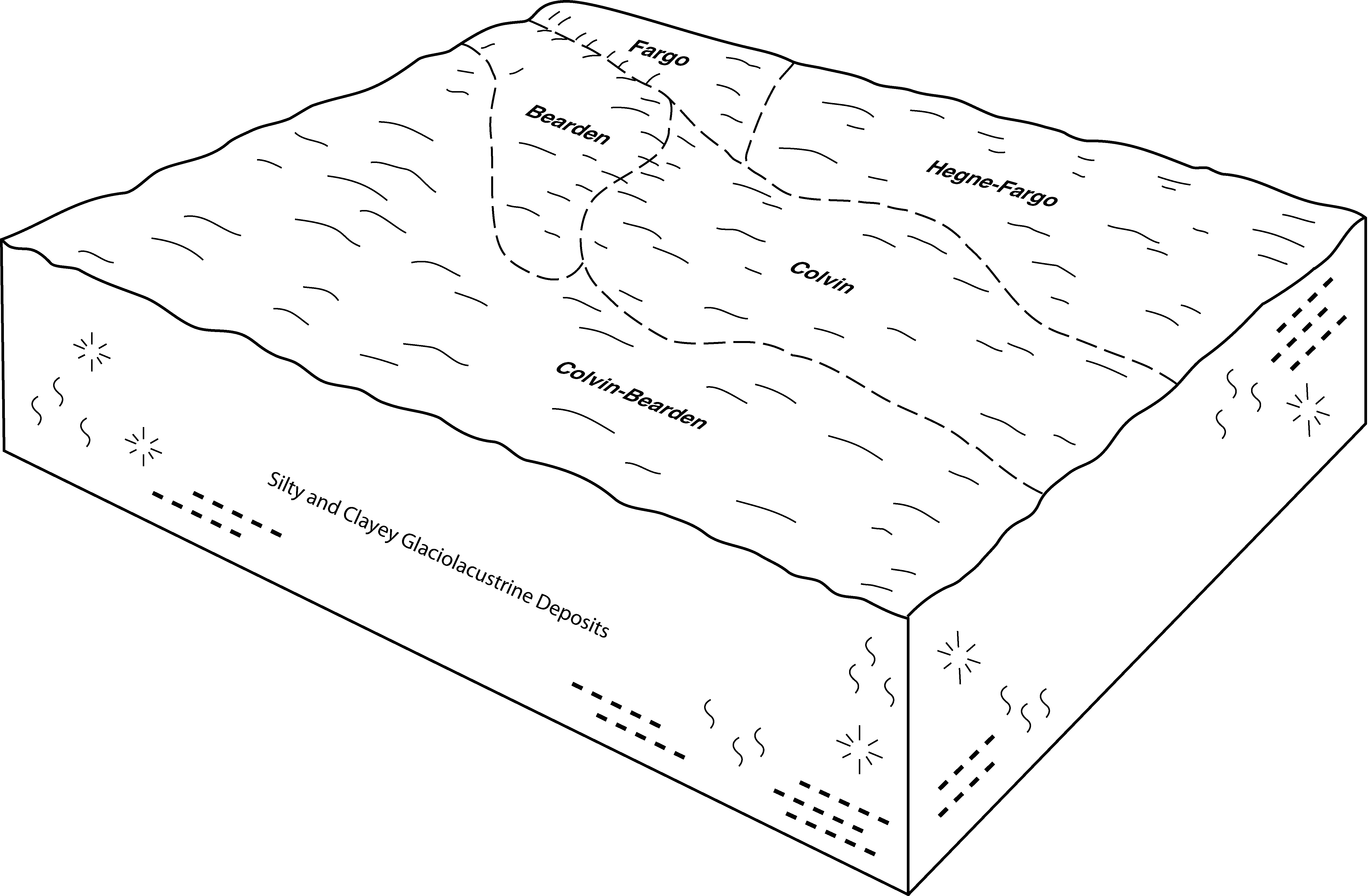
Hegne-Fargo silty clays, 0 to 1 percent slopes | I130A | 5525 | 2798095 | 21qd9 | mn027 | 1980 | 1:20000 |
Fargo silty clay loam, 0 to 1 percent slopes | I233A | 2966 | 2798081 | 1nysv | mn027 | 1980 | 1:20000 |
Fargo silty clay, silty substratum, depressional, 0 to 1 percent slopes | I642A | 1558 | 2798107 | 2pgc0 | mn027 | 1980 | 1:20000 |
Fargo silty clay, silty substratum | 1872 | 2 | 356948 | czfg | mn027 | 1980 | 1:20000 |
Fargo silty clay, till-floored lake plain, 0 to 1 percent slopes | I639A | 1840 | 2798202 | 2pgbv | mn051 | 1974 | 1:20000 |
Hegne-Fargo silty clays, silty substratum, 0 to 1 percent slopes | I134A | 54445 | 2798877 | 21wns | mn069 | 2007 | 1:12000 |
Hegne-Fargo silty clays, 0 to 1 percent slopes | I130A | 5943 | 2798874 | 21qd9 | mn069 | 2007 | 1:12000 |
Colvin-Fargo complex, 0 to 1 percent slopes | I124A | 2332 | 2798868 | 21qd3 | mn069 | 2007 | 1:12000 |
Fargo silty clay, depressional, 0 to 1 percent slopes | I235A | 502 | 2798417 | 1nysz | mn069 | 2007 | 1:12000 |
Fargo silty clay, 0 to 1 percent slopes | I229A | 63555 | 2798950 | 1nysr | mn089 | 1994 | 1:20000 |
Hegne-Fargo silty clays, 0 to 1 percent slopes | I130A | 53246 | 2798997 | 21qd9 | mn089 | 1994 | 1:20000 |
Colvin-Fargo complex, 0 to 1 percent slopes | I124A | 52086 | 2798993 | 21qd3 | mn089 | 1994 | 1:20000 |
Hegne-Fargo silty clays, 0 to 1 percent slopes | I130A | 51770 | 2799077 | 21qd9 | mn107 | 1970 | 1:20000 |
Bearden-Fargo complex, 0 to 2 percent slopes | I627A | 42634 | 2799096 | 2pgbc | mn107 | 1970 | 1:20000 |
Fargo silty clay, 0 to 1 percent slopes | I229A | 39790 | 2799064 | 1nysr | mn107 | 1970 | 1:20000 |
Fargo silty clay loam, 0 to 1 percent slopes | I233A | 16128 | 2799065 | 1nysv | mn107 | 1970 | 1:20000 |
Fargo silty clay, depressional, 0 to 1 percent slopes | I235A | 1796 | 2799066 | 1nysz | mn107 | 1970 | 1:20000 |
Colvin-Fargo complex, 0 to 1 percent slopes | I124A | 28263 | 2799704 | 21qd3 | mn119 | 1996 | 1:20000 |
Bearden-Fargo complex, 0 to 2 percent slopes | I627A | 17963 | 2799718 | 2pgbc | mn119 | 1996 | 1:20000 |
Hegne-Fargo silty clays, 0 to 1 percent slopes | I130A | 4840 | 2799705 | 21qd9 | mn119 | 1996 | 1:20000 |
Fargo silty clay, 0 to 1 percent slopes | I229A | 1694 | 2799689 | 1nysr | mn119 | 1996 | 1:20000 |
Fargo silty clay loam, 0 to 1 percent slopes | I233A | 91 | 2799690 | 1nysv | mn119 | 1996 | 1:20000 |
Fargo silty clay, depressional, 0 to 1 percent slopes | I235A | 12 | 2799691 | 1nysz | mn119 | 1996 | 1:20000 |
Fargo silty clay, till-floored lake plain, 0 to 1 percent slopes | I639A | 49 | 2799921 | 2pgbv | mn149 | 1966 | 1:15840 |
Fargo silty clay loam, 0 to 1 percent slopes | I233A | 7720 | 2799937 | 1nysv | mn155 | 1986 | 1:20000 |
Fargo silty clay, till-floored lake plain, 0 to 1 percent slopes | I639A | 4417 | 2799962 | 2pgbv | mn155 | 1986 | 1:20000 |
Fargo-Mustinka silty clay loams, 0 to 1 percent slopes | I643A | 2756 | 2799963 | 2pgc4 | mn155 | 1986 | 1:20000 |
Fargo clay, moderately saline, 0 to 1 percent slopes | I637A | 2178 | 2799961 | 2pgbs | mn155 | 1986 | 1:20000 |
Fargo silty clay, till-floored lake plain, 0 to 1 percent slopes | I639A | 6585 | 2800432 | 2pgbv | mn167 | 1985 | 1:20000 |
Fargo silty clay, 0 to 1 percent slopes | I229A | 3567 | 2799997 | 1nysr | mn167 | 1985 | 1:20000 |
Fargo silty clay loam, 0 to 1 percent slopes | I233A | 2318 | 2799998 | 1nysv | mn167 | 1985 | 1:20000 |
Fargo-Mustinka silty clay loams, 0 to 1 percent slopes | I643A | 2166 | 2800434 | 2pgc4 | mn167 | 1985 | 1:20000 |
Fargo silty clay, silty substratum, 0 to 1 percent slopes | I641A | 2044 | 2800433 | 2pgby | mn167 | 1985 | 1:20000 |
Fargo silty clay, depressional, 0 to 1 percent slopes | I235A | 1845 | 2799999 | 1nysz | mn167 | 1985 | 1:20000 |
Bearden-Fargo complex, 0 to 2 percent slopes | I627A | 391 | 2800443 | 2pgbc | mn167 | 1985 | 1:20000 |
Fargo-Hegne silty clays | Fa | 853 | 147353 | 4ybb | mt602 | 1963 | 1:20000 |
Fargo silty clay, 0 to 1 percent slopes | G410A | 3440 | 2573607 | 2q5cb | nd003 | 1988 | 1:20000 |
Fargo silty clay, 0 to 2 percent slopes, occasionally flooded | G420A | 128 | 2573610 | 2q5ck | nd003 | 1988 | 1:20000 |
Fargo silty clay, 0 to 1 percent slopes | F410A | 1721 | 2587691 | 2q54y | nd005 | | 1:12000 |
Fargo-Hegne silty clays, 0 to 1 percent slopes | F411A | 16 | 2587763 | 2q54z | nd005 | | 1:12000 |
Fargo silty clay, 0 to 1 percent slopes | F410A | 27029 | 2585981 | 2q54y | nd009 | 1981 | 1:20000 |
Fargo-Hegne silty clays, 0 to 1 percent slopes, frequently ponded | F49A | 6064 | 2585945 | 2q4g0 | nd009 | 1981 | 1:20000 |
Fargo silty clay, 0 to 1 percent slopes | I229A | 177592 | 2521602 | 1nysr | nd017 | 1983 | 1:20000 |
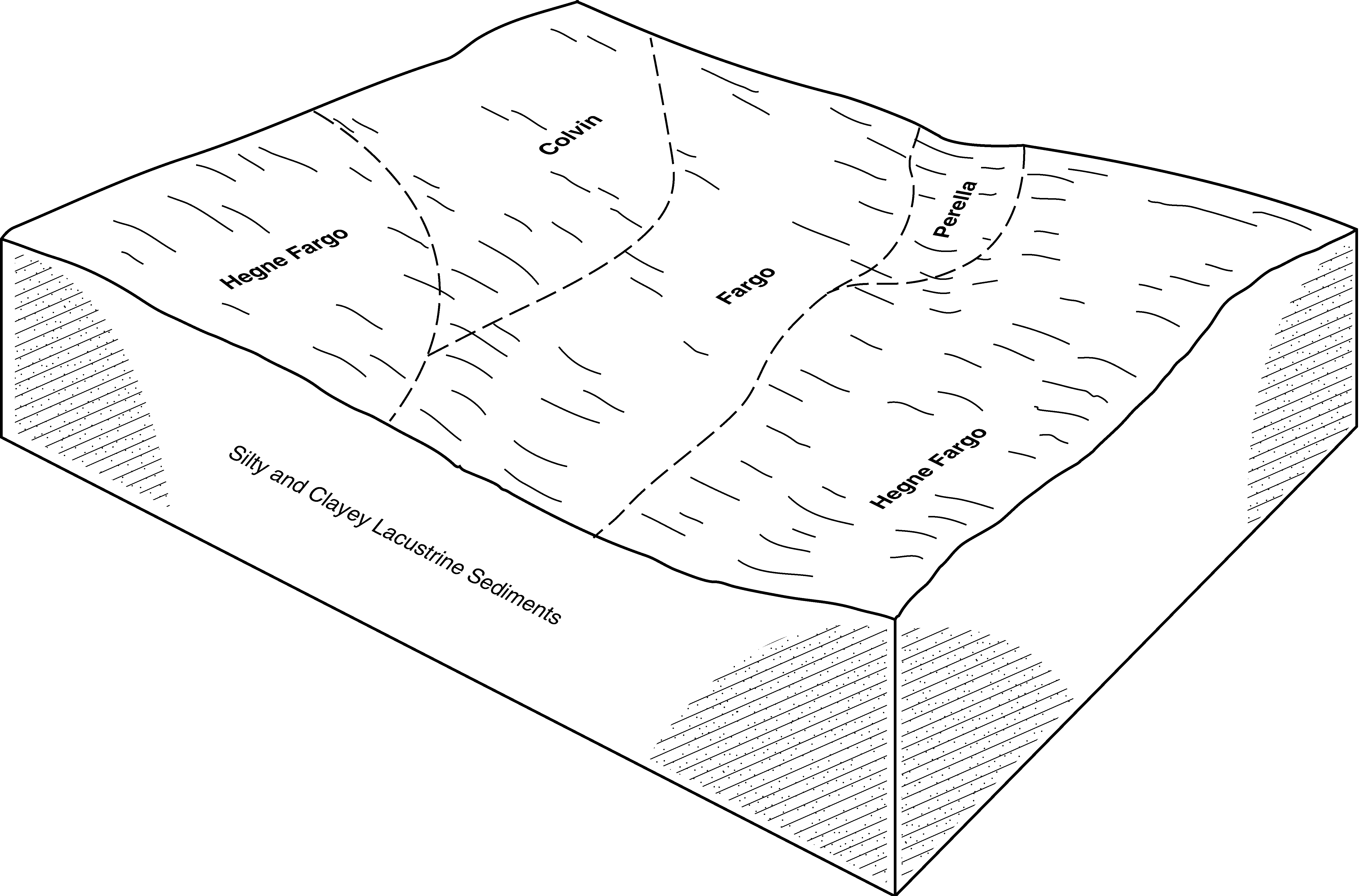
Fargo-Hegne silty clays, 0 to 1 percent slopes | I238A | 95214 | 2640875 | 1nyt2 | nd017 | 1983 | 1:20000 |
Fargo silty clay loam, 0 to 1 percent slopes | I233A | 30660 | 2521590 | 1nysv | nd017 | 1983 | 1:20000 |
Fargo silty clay, depressional, 0 to 1 percent slopes | I235A | 29874 | 2640843 | 1nysz | nd017 | 1983 | 1:20000 |
Hegne-Fargo silty clay loams, 0 to 1 percent slopes | I473A | 23592 | 2640844 | 1tblt | nd017 | 1983 | 1:20000 |
Fargo-Ryan, thick solum silty clays, 0 to 1 percents slopes | I241A | 14789 | 2640867 | 2xbww | nd017 | 1983 | 1:20000 |
Galchutt-Fargo silty clay loams, 0 to 2 percent slopes | I491A | 10740 | 2640907 | 1tbnb | nd017 | 1983 | 1:20000 |
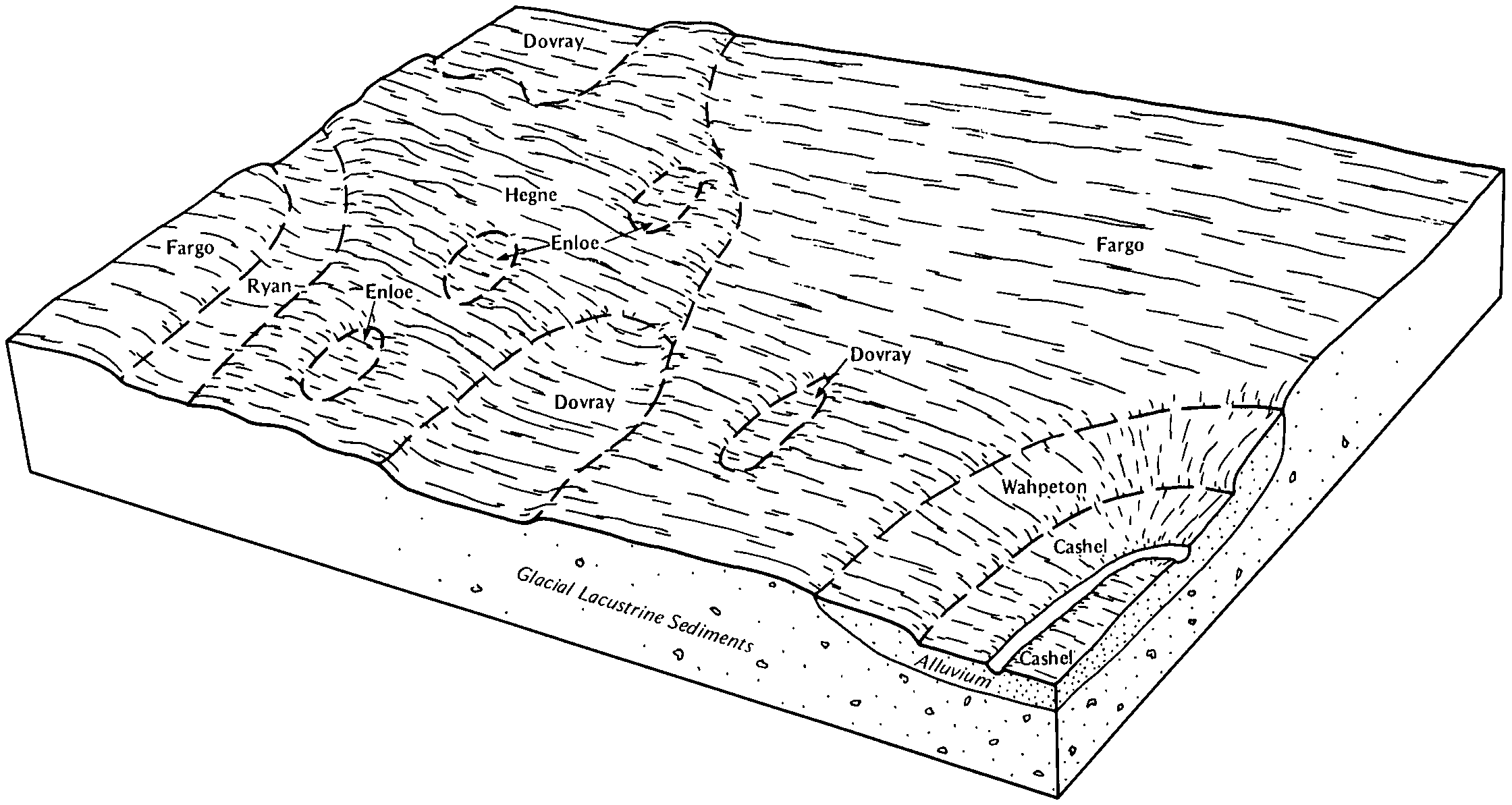
Fargo-Enloe complex, 0 to 1 percent slopes | I237A | 9475 | 2521579 | 1nyt1 | nd017 | 1983 | 1:20000 |
Fargo silty clay, moderately saline, 0 to 1 percent slopes | I469A | 6142 | 2640856 | 1tblj | nd017 | 1983 | 1:20000 |
Fargo-Nutley silty clays, 0 to 2 percent slopes | I234A | 4078 | 2640851 | 1nysw | nd017 | 1983 | 1:20000 |
Fargo silty clay, 0 to 1 percent slopes | G410A | 213 | 2575099 | 2q5cb | nd017 | 1983 | 1:20000 |
Fargo-Ryan, thick solum silty clay loams, 0 to 1 percent slopes | I240A | 143 | 2521610 | 2xbwv | nd017 | 1983 | 1:20000 |
Fargo-Hegne silty clays, 0 to 1 percent slopes, frequently ponded | G49A | 80 | 2575087 | 2q4nm | nd017 | 1983 | 1:20000 |
Nutley-Fargo, dry, silty clays, 2 to 6 percent slopes | I234B | 30 | 2640897 | 1nysx | nd017 | 1983 | 1:20000 |
Hegne-Fargo silty clays, 0 to 1 percent slopes | I130A | 3213 | 2643063 | 21qd9 | nd019 | 1987 | 1:20000 |
Hegne-Fargo silty clays, 0 to 1 percent slopes | I130A | 43 | 2642529 | 21qd9 | nd035 | 1980 | 1:20000 |
Fargo-Hegne silty clays, 0 to 1 percent slopes | C427A | 732 | 2566463 | 2q1pc | nd045 | 1966 | 1:20000 |
Fargo silty clay, 0 to 2 percent slopes, occasionally flooded | G420A | 697 | 2577079 | 2q5ck | nd045 | 1966 | 1:20000 |
Hegne, occasionally flooded-Fargo silty clays, terrace, 0 to 2 percent slopes | G421A | 144 | 2577080 | 2q5cl | nd045 | 1966 | 1:20000 |
Fargo silty clay, 0 to 1 percent slopes | F410A | 833 | 2585687 | 2q54y | nd049 | 1987 | 1:20000 |
Fargo silty clay, 0 to 1 percent slopes | G410A | 79 | 2571374 | 2q5cb | nd049 | 1987 | 1:20000 |
Fargo-Hegne silty clays, 0 to 1 percent slopes, frequently ponded | F49A | 21 | 2585644 | 2q4g0 | nd049 | 1987 | 1:20000 |
Hegne-Fargo silty clays, 0 to 1 percent slopes | I130A | 86066 | 2642996 | 21qd9 | nd067 | 1972 | 1:20000 |
Fargo silty clay, 0 to 1 percent slopes | I229A | 36326 | 2642954 | 1nysr | nd067 | 1972 | 1:20000 |
Ryan-Fargo silty clays, 0 to 1 percent slopes | I242A | 11371 | 2642957 | 1nyt6 | nd067 | 1972 | 1:20000 |
Nutley-Fargo, dry, silty clays, 2 to 6 percent slopes | I234B | 1005 | 2642956 | 1nysx | nd067 | 1972 | 1:20000 |
Fargo-Hegne silty clays, 0 to 1 percent slopes, frequently ponded | F49A | 1543 | 2587220 | 2q4g0 | nd069 | 1975 | 1:20000 |
Fargo-Hegne silty clays, 0 to 1 percent slopes | F411A | 21876 | 2587124 | 2q54z | nd071 | 1984 | 1:12000 |
Aberdeen-Fargo silty clay loams, 0 to 2 percent slopes | F459A | 3714 | 2587138 | 2q55q | nd071 | 1984 | 1:12000 |
Fargo silty clay, 0 to 1 percent slopes | F410A | 1892 | 2587123 | 2q54y | nd071 | 1984 | 1:12000 |
Hegne-Fargo silty clay loams, 0 to 1 percent slopes | I473A | 31 | 2641331 | 1tblt | nd073 | 1992 | 1:20000 |
Fargo silty clay, 0 to 1 percent slopes | F410A | 1627 | 2585402 | 2q54y | nd075 | 1972 | 1:20000 |
Fargo-Hegne silty clays, 0 to 1 percent slopes, frequently ponded | F49A | 605 | 2585379 | 2q4g0 | nd075 | 1972 | 1:20000 |
Fargo silty clay, 0 to 1 percent slopes | I229A | 52376 | 2640984 | 1nysr | nd077 | 2005 | 1:12000 |
Ryan-Fargo silty clays, 0 to 1 percent slopes | I242A | 24462 | 2641154 | 1nyt6 | nd077 | 2005 | 1:12000 |
Fargo-Enloe complex, 0 to 1 percent slopes | I237A | 16794 | 2640952 | 1nyt1 | nd077 | 2005 | 1:12000 |
Fargo silty clay loam, 0 to 1 percent slopes | I233A | 14212 | 2640965 | 1nysv | nd077 | 2005 | 1:12000 |
Fargo-Ryan, thick solum silty clays, 0 to 1 percents slopes | I241A | 13519 | 2641072 | 2xbww | nd077 | 2005 | 1:12000 |
Fargo-Hegne silty clays, 0 to 1 percent slopes | I238A | 7815 | 2641091 | 1nyt2 | nd077 | 2005 | 1:12000 |
Galchutt-Enloe-Fargo silty clay loams, 0 to 2 percent slopes | I245A | 5917 | 2641138 | 1nyt9 | nd077 | 2005 | 1:12000 |
Aberdeen-Galchutt-Fargo complex, 0 to 2 percent slopes | I251A | 5747 | 2494565 | 1nyth | nd077 | 2005 | 1:12000 |
Fargo silty clay, depressional, 0 to 1 percent slopes | I235A | 4989 | 2641027 | 1nysz | nd077 | 2005 | 1:12000 |
Nutley-Fargo, dry, silty clays, 2 to 6 percent slopes | I234B | 4101 | 2641126 | 1nysx | nd077 | 2005 | 1:12000 |
Fargo-Ryan, thick solum silty clay loams, 0 to 1 percent slopes | I240A | 2934 | 2640994 | 2xbwv | nd077 | 2005 | 1:12000 |
Fargo-Nutley silty clays, 0 to 2 percent slopes | I234A | 2741 | 2641044 | 1nysw | nd077 | 2005 | 1:12000 |
Fargo silty clay, 0 to 1 percent slopes | G410A | 358 | 2577414 | 2q5cb | nd077 | 2005 | 1:12000 |
Fargo silty clay, 0 to 1 percent slopes | J207A | 251 | 1544947 | 1nvn0 | nd077 | 2005 | 1:12000 |
Fargo-Hegne silty clays, 0 to 1 percent slopes, frequently ponded | G49A | 145 | 2577411 | 2q4nm | nd077 | 2005 | 1:12000 |
Fargo silty clay, 0 to 1 percent slopes | G410A | 1609 | 2579500 | 2q5cb | nd081 | 1959 | 1:12000 |
Fargo-Hegne silty clays, 0 to 1 percent slopes | G411A | 939 | 2579523 | 2q5cc | nd081 | 1959 | 1:12000 |
Fargo clay | Fc | 645 | 341578 | cgfn | nd081 | 1959 | 1:12000 |
Fargo-Hegne silty clays, saline, 0 to 1 percent slopes | G413A | 472 | 2579463 | 2q5cf | nd081 | 1959 | 1:12000 |
Hegne-Fargo clays | HfA | 298 | 341593 | cgg4 | nd081 | 1959 | 1:12000 |
Fargo-Hegne silty clays, saline, 0 to 1 percent slopes | Fh | 139 | 1722442 | 1vtbn | nd081 | 1959 | 1:12000 |
Fargo silty clay, 0 to 1 percent slopes | C428A | 1 | 2567193 | 2q1pd | nd083 | 1990 | 1:20000 |
Fargo-Hegne silty clays, 0 to 1 percent slopes | C427A | 1525 | 2661636 | 2q1pc | nd093 | 1990 | 1:24000 |
Fargo-Colvin silty clay loams, 0 to 1 percent slopes | G419A | 274 | 2581378 | 2q5cj | nd093 | 1990 | 1:24000 |
Fargo silty clay, 0 to 2 percent slopes, occasionally flooded | G420A | 66 | 2581379 | 2q5ck | nd093 | 1990 | 1:24000 |
Fargo-Hegne silty clays, 0 to 1 percent slopes | F411A | 4177 | 2587067 | 2q54z | nd095 | 1992 | 1:24000 |
Fargo silty clay, 0 to 1 percent slopes | I229A | 65832 | 2641581 | 1nysr | nd097 | 1974 | 1:20000 |
Fargo-Hegne silty clays, 0 to 1 percent slopes | I238A | 34013 | 2641592 | 1nyt2 | nd097 | 1974 | 1:20000 |
Hegne-Fargo silty clays, 0 to 1 percent slopes | I130A | 7165 | 2642481 | 21qd9 | nd097 | 1974 | 1:20000 |
Galchutt-Fargo silty clay loams, 0 to 2 percent slopes | I491A | 6872 | 2642443 | 1tbnb | nd097 | 1974 | 1:20000 |
Fargo-Enloe complex, 0 to 1 percent slopes | I237A | 6740 | 2641591 | 1nyt1 | nd097 | 1974 | 1:20000 |
Fargo silty clay loam, 0 to 1 percent slopes | I233A | 5008 | 2641586 | 1nysv | nd097 | 1974 | 1:20000 |
Fargo-Nutley silty clays, 0 to 2 percent slopes | I234A | 4827 | 2641587 | 1nysw | nd097 | 1974 | 1:20000 |
Overly-Fargo complex, 0 to 2 percent slopes | I175A | 2637 | 2642479 | 2l6xb | nd097 | 1974 | 1:20000 |
Fargo-Ryan, thick solum silty clays, 0 to 1 percents slopes | I241A | 1044 | 2641593 | 2xbww | nd097 | 1974 | 1:20000 |
Nutley-Fargo, dry, silty clays, 2 to 6 percent slopes | I234B | 101 | 2641588 | 1nysx | nd097 | 1974 | 1:20000 |
Fargo silty clay, depressional, 0 to 1 percent slopes | I235A | 7 | 2641590 | 1nysz | nd097 | 1974 | 1:20000 |
Hegne-Fargo silty clays, 0 to 1 percent slopes | I130A | 72038 | 2642880 | 21qd9 | nd099 | 1967 | 1:20000 |
Fargo silty clay, 0 to 1 percent slopes | I229A | 14737 | 2642830 | 1nysr | nd099 | 1967 | 1:20000 |
Fargo silty clay, depressional, 0 to 1 percent slopes | I235A | 3646 | 2642835 | 1nysz | nd099 | 1967 | 1:20000 |
Nutley-Fargo, dry, silty clays, 2 to 6 percent slopes | I234B | 483 | 2642833 | 1nysx | nd099 | 1967 | 1:20000 |
Fargo silty clay, 0 to 1 percent slopes | F410A | 440 | 2585199 | 2q54y | nd101 | 1967 | 1:20000 |
Fargo-Hegne silty clays, 0 to 1 percent slopes | C427A | 411 | 2661644 | 2q1pc | nd101 | 1967 | 1:20000 |
Fargo silty clay, 0 to 1 percent slopes | C428A | 1664 | 2566970 | 2q1pd | nd103 | 1966 | 1:12000 |
Fargo-Aberdeen complex, 0 to 2 percent slopes | G471A | 1099 | 2579662 | 2q5nj | nd103 | 1966 | 1:12000 |