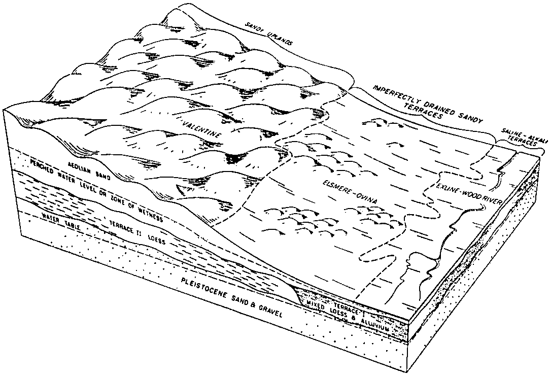
| Exline silt loam, 0 to 2 percent slopes | G462A | 1608 | 2573615 | 2q5n9 | nd003 | 1988 | 1:20000 |
Exline silt loam, 0 to 2 percent slopes | F462A | 14816 | 2586057 | 2q55t | nd009 | 1981 | 1:20000 |
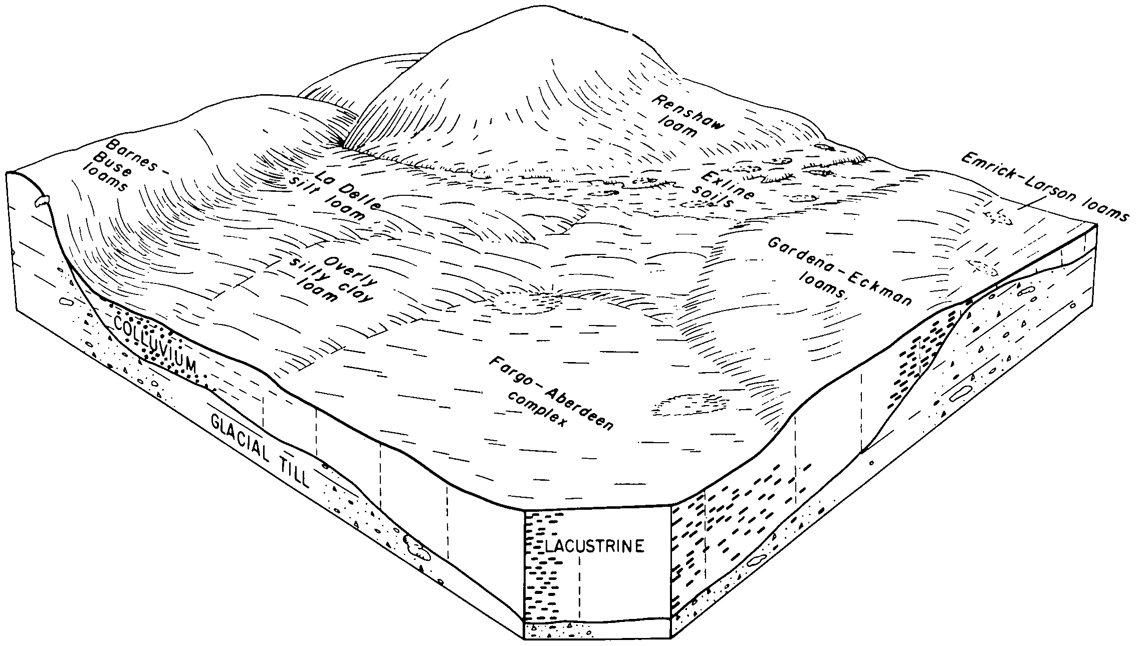
Aberdeen-Exline silt loams, 0 to 2 percent slopes | F463A | 9425 | 2585928 | 2q55v | nd009 | 1981 | 1:20000 |
Exline silt loam, 0 to 2 percent slopes | G462A | 1197 | 2575342 | 2q5n9 | nd021 | 1989 | 1:20000 |
Aberdeen-Exline silt loams, 0 to 2 percent slopes | G463A | 485 | 2575343 | 2q5nb | nd021 | 1989 | 1:20000 |
Exline silt loam, 0 to 2 percent slopes | G462A | 123 | 2576314 | 2q5n9 | nd027 | | 1:12000 |
Aberdeen-Exline silt loams, 0 to 2 percent slopes | G463A | 23 | 2576315 | 2q5nb | nd027 | | 1:12000 |
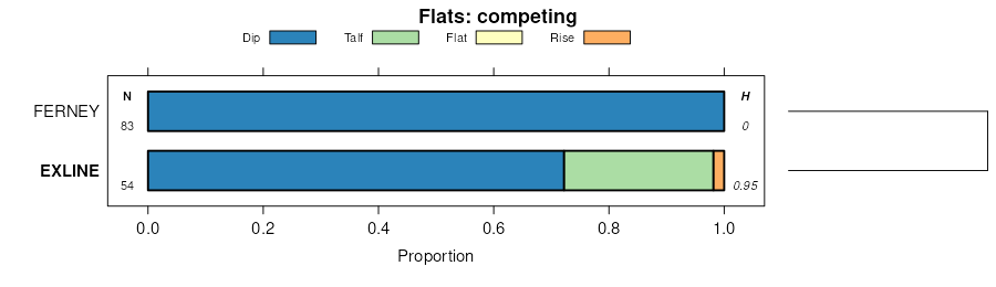
Exline-Aberdeen silty clays, 0 to 1 percent slopes | I167A | 508 | 2642583 | 2mbkb | nd035 | 1980 | 1:20000 |
Exline silt loam, 0 to 2 percent slopes | G462A | 797 | 2577085 | 2q5n9 | nd045 | 1966 | 1:20000 |
Exline silt loam, 0 to 2 percent slopes | G462A | 92 | 2577203 | 2q5n9 | nd055 | 1974 | 1:20000 |
Exline silt loam, 0 to 2 percent slopes | G462A | 289 | 2577337 | 2q5n9 | nd063 | | 1:12000 |
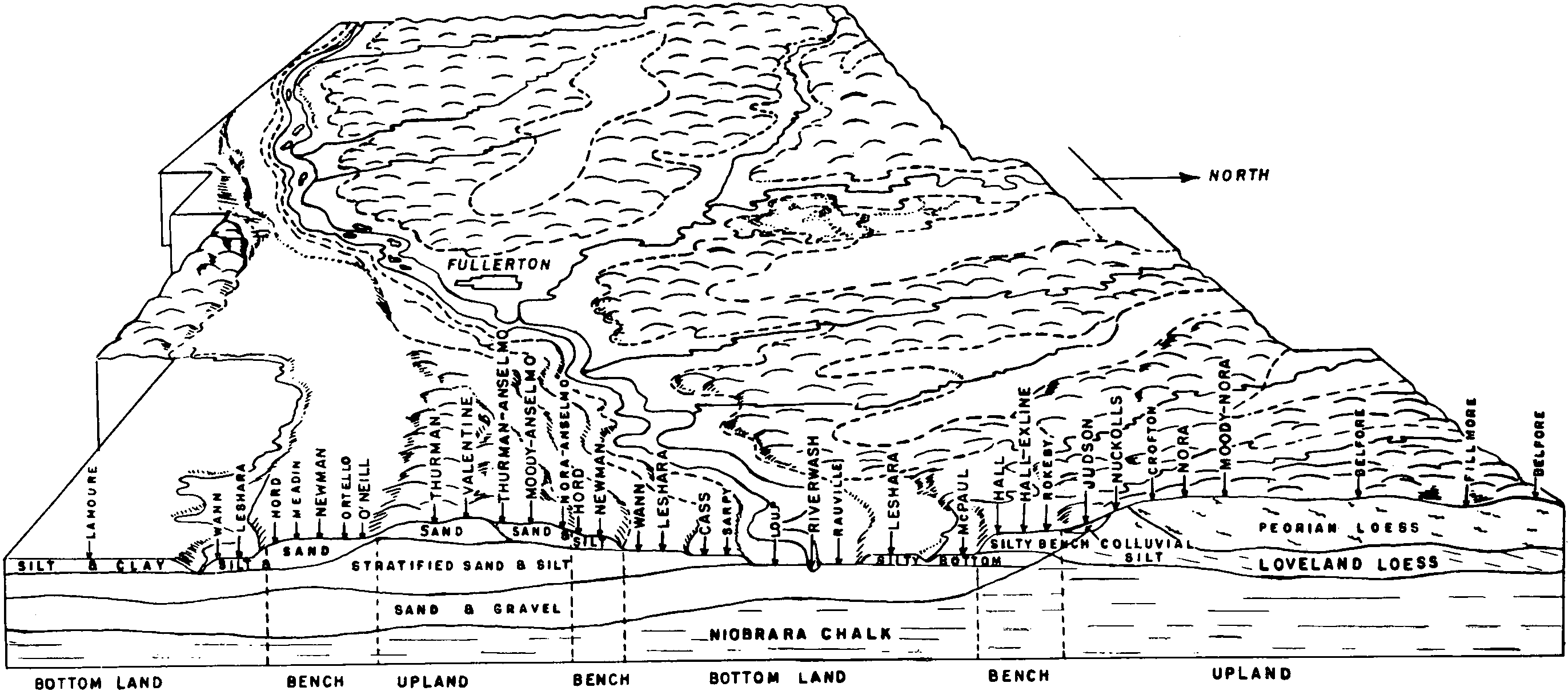
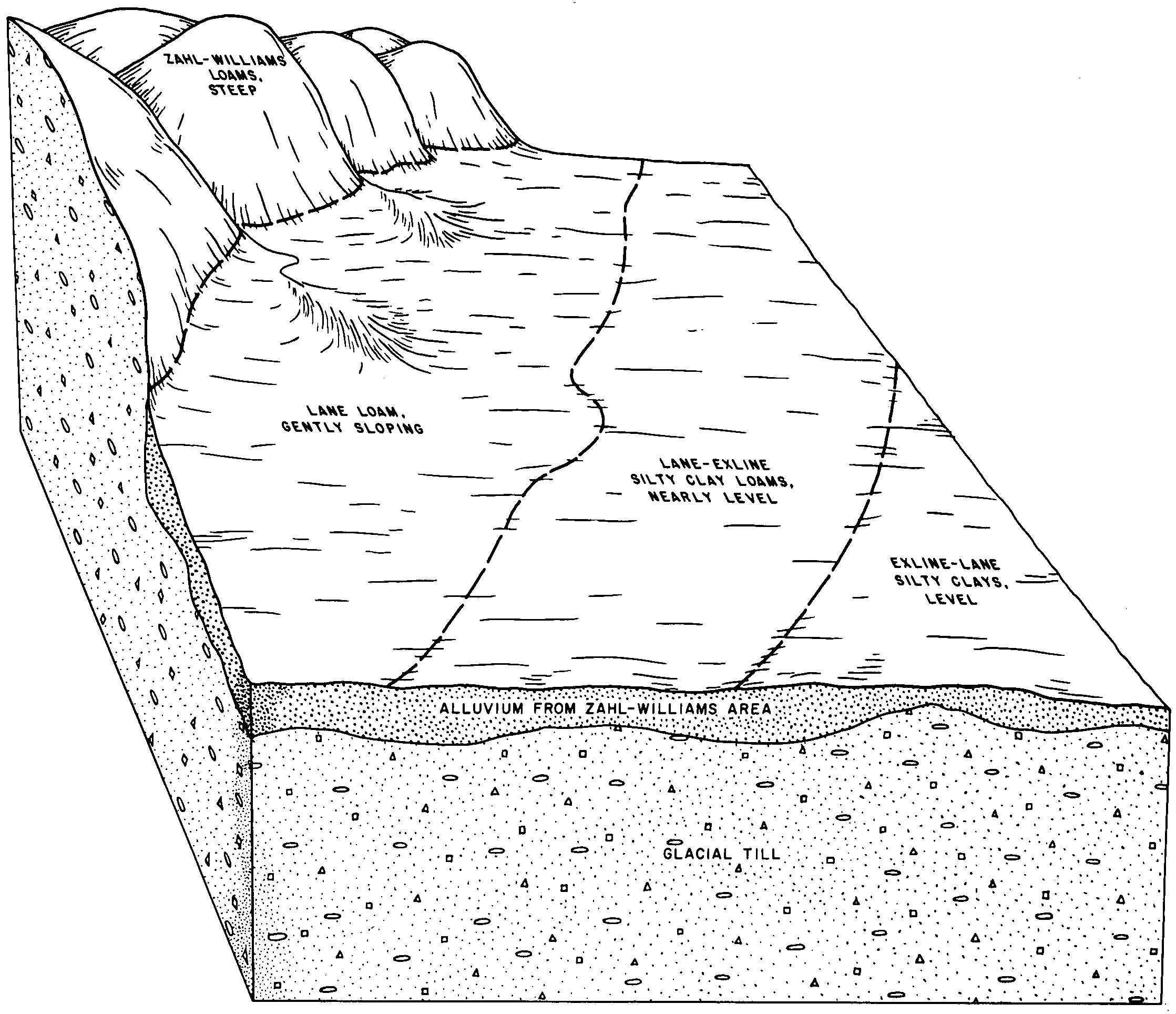
Exline loam, moderately deep over sandy substratum, 0 to 2 percent slopes | I562A | 975 | 3247903 | 2yw6l | nd073 | 1992 | 1:20000 |
Exline loam, sandy substratum, 0 to 2 percent slopes | I253A | 147 | 2641276 | 1nytk | nd073 | 1992 | 1:20000 |
Exline loam, sandy substratum, 0 to 2 percent slopes | I253A | 1211 | 2641077 | 1nytk | nd077 | 2005 | 1:12000 |
Exline loam, moderately deep over sandy substratum, 0 to 2 percent slopes | I562A | 195 | 3247912 | 2yw6l | nd077 | 2005 | 1:12000 |
Exline silt loam, 0 to 2 percent slopes | F462A | 109 | 2588198 | 2q55t | nd079 | 1990 | 1:24000 |
Aberdeen-Exline silt loams, 0 to 2 percent slopes | F463A | 4 | 2588048 | 2q55v | nd079 | 1990 | 1:24000 |
Exline loam, sandy substratum, 0 to 2 percent slopes | I253A | 153 | 2641203 | 1nytk | nd081 | 1959 | 1:12000 |
Exline loam, moderately deep over sandy substratum, 0 to 2 percent slopes | I562A | 31 | 3247907 | 2yw6l | nd081 | 1959 | 1:12000 |
Exline silt loam, 0 to 2 percent slopes | G462A | 2434 | 2581383 | 2q5n9 | nd093 | 1990 | 1:24000 |
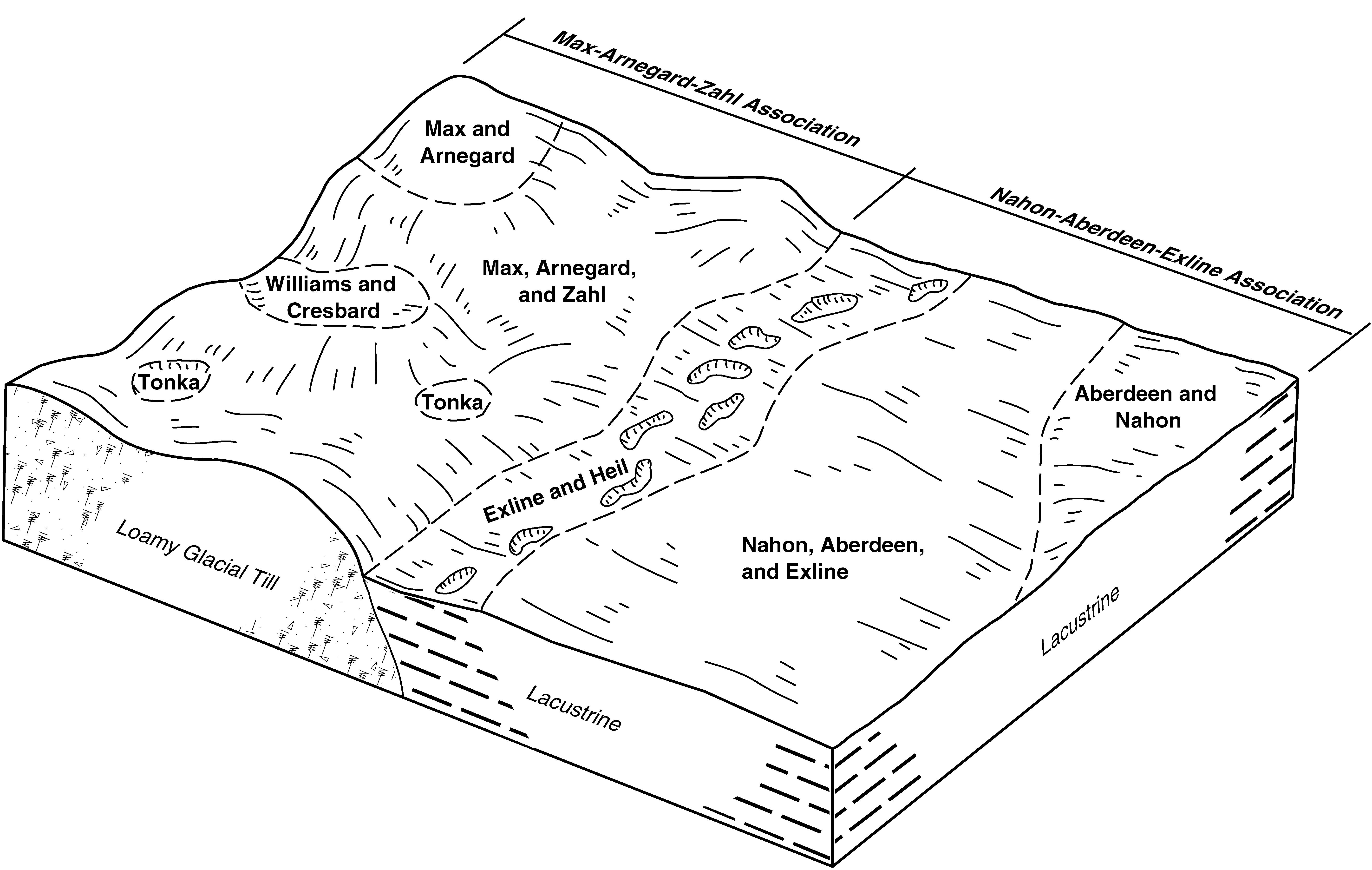
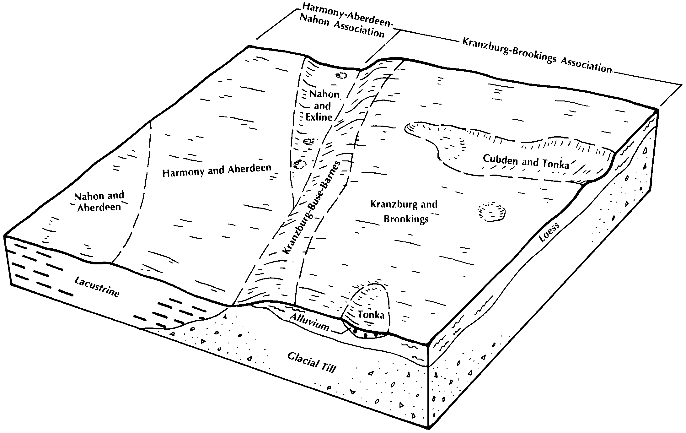
Nahon-Aberdeen-Exline silt loams, 0 to 2 percent slopes | G851A | 15935 | 2797830 | 2sd6h | sd013 | 1987 | 1:20000 |
Exline-Aberdeen-Nahon silt loams, 0 to 2 percent slopes | G845A | 9574 | 2797826 | 2sd69 | sd013 | 1987 | 1:20000 |
Exline-Putney silt loams, 1 to 6 percent slopes | G850B | 8455 | 2797829 | 2sd6g | sd013 | 1987 | 1:20000 |
Turton-Exline, loamy complex, 0 to 2 percent slopes | G715A | 2114 | 2797804 | 2sd4z | sd013 | 1987 | 1:20000 |
Swenoda, silty substratum-Exline, loamy, fine sandy loams, 0 to 2 percent slopes | G755A | 621 | 2797817 | 2sd5h | sd013 | 1987 | 1:20000 |
Nahon-Aberdeen-Exline silty clay loams, sandy substratum, 0 to 2 percent slopes | G853A | 556 | 2797832 | 2sd6k | sd013 | 1987 | 1:20000 |
Nahon-Aberdeen-Exline silt loams, till substratum, 0 to 2 percent slopes | G852A | 258 | 2797831 | 2sd6j | sd013 | 1987 | 1:20000 |
Exline-Aberdeen-Nahon silt loams, till substratum, 0 to 2 percent slopes | G846A | 178 | 2797827 | 2sd6b | sd013 | 1987 | 1:20000 |
Exline-Heil silt loams, 0 to 2 percent slopes | G848A | 3 | 2797828 | 2sd6d | sd013 | 1987 | 1:20000 |
Exline silt loam, 0 to 2 percent slopes | G462A | 3 | 2797683 | 2q5n9 | sd013 | 1987 | 1:20000 |
Nahon-Aberdeen-Exline silt loams, 0 to 2 percent slopes | G851A | 2474 | 2798534 | 2sd6h | sd037 | 1992 | 1:20000 |
Nahon-Aberdeen-Exline silt loams, till substratum, 0 to 2 percent slopes | G852A | 2163 | 2798535 | 2sd6j | sd037 | 1992 | 1:20000 |
Exline-Putney silt loams, 1 to 6 percent slopes | G850B | 997 | 2798533 | 2sd6g | sd037 | 1992 | 1:20000 |
Exline-Aberdeen-Nahon silt loams, 0 to 2 percent slopes | G845A | 796 | 2798531 | 2sd69 | sd037 | 1992 | 1:20000 |
Exline-Aberdeen-Nahon silt loams, till substratum, 0 to 2 percent slopes | G846A | 254 | 2798532 | 2sd6b | sd037 | 1992 | 1:20000 |
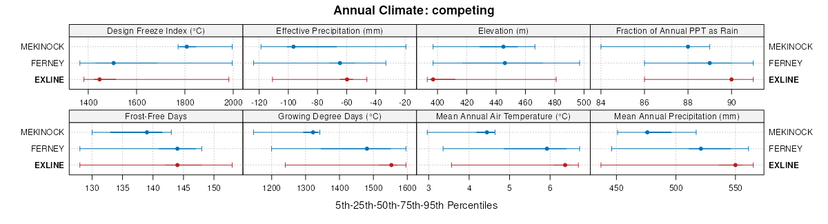
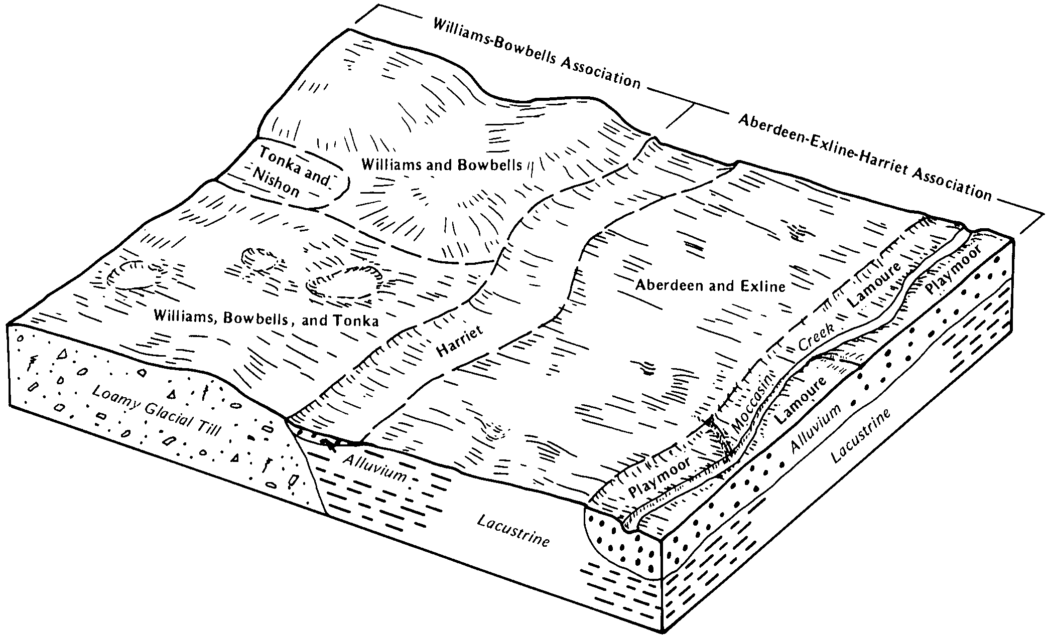
Harmony-Exline complex, 0 to 2 percent slopes | G867A | 1473 | 2799256 | 2sd6r | sd089 | 1980 | 1:20000 |
Exline-Harmony complex, till substratum, 0 to 2 percent slopes | G847A | 713 | 2799254 | 2sd6c | sd089 | 1980 | 1:20000 |
Nahon-Aberdeen-Exline silt loams, 0 to 2 percent slopes | G851A | 14099 | 2799387 | 2sd6h | sd091 | 1970 | 1:20000 |
Exline-Aberdeen-Nahon silt loams, 0 to 2 percent slopes | G845A | 6329 | 2799385 | 2sd69 | sd091 | 1970 | 1:20000 |
Exline-Aberdeen-Nahon silt loams, till substratum, 0 to 2 percent slopes | G846A | 158 | 2799386 | 2sd6b | sd091 | 1970 | 1:20000 |
Nahon-Aberdeen-Exline silt loams, till substratum, 0 to 2 percent slopes | G852A | 107 | 2799388 | 2sd6j | sd091 | 1970 | 1:20000 |
Nahon-Aberdeen-Exline silt loams, 0 to 2 percent slopes | G851A | 52214 | 2800048 | 2sd6h | sd115 | 1997 | 1:24000 |
Exline-Heil silt loams, 0 to 2 percent slopes | G848A | 15912 | 2800045 | 2sd6d | sd115 | 1997 | 1:24000 |
Exline-Aberdeen-Nahon silt loams, 0 to 2 percent slopes | G845A | 13586 | 2800043 | 2sd69 | sd115 | 1997 | 1:24000 |
Nahon-Aberdeen-Exline silt loams, till substratum, 0 to 2 percent slopes | G852A | 4213 | 2800049 | 2sd6j | sd115 | 1997 | 1:24000 |
Exline-Aberdeen-Nahon silt loams, till substratum, 0 to 2 percent slopes | G846A | 3822 | 2800044 | 2sd6b | sd115 | 1997 | 1:24000 |
Exline-Heil silt loams, till substratum, 0 to 2 percent slopes | G849A | 1368 | 2800046 | 2sd6f | sd115 | 1997 | 1:24000 |
Exline-Putney silt loams, 1 to 6 percent slopes | G850B | 1163 | 2800047 | 2sd6g | sd115 | 1997 | 1:24000 |


