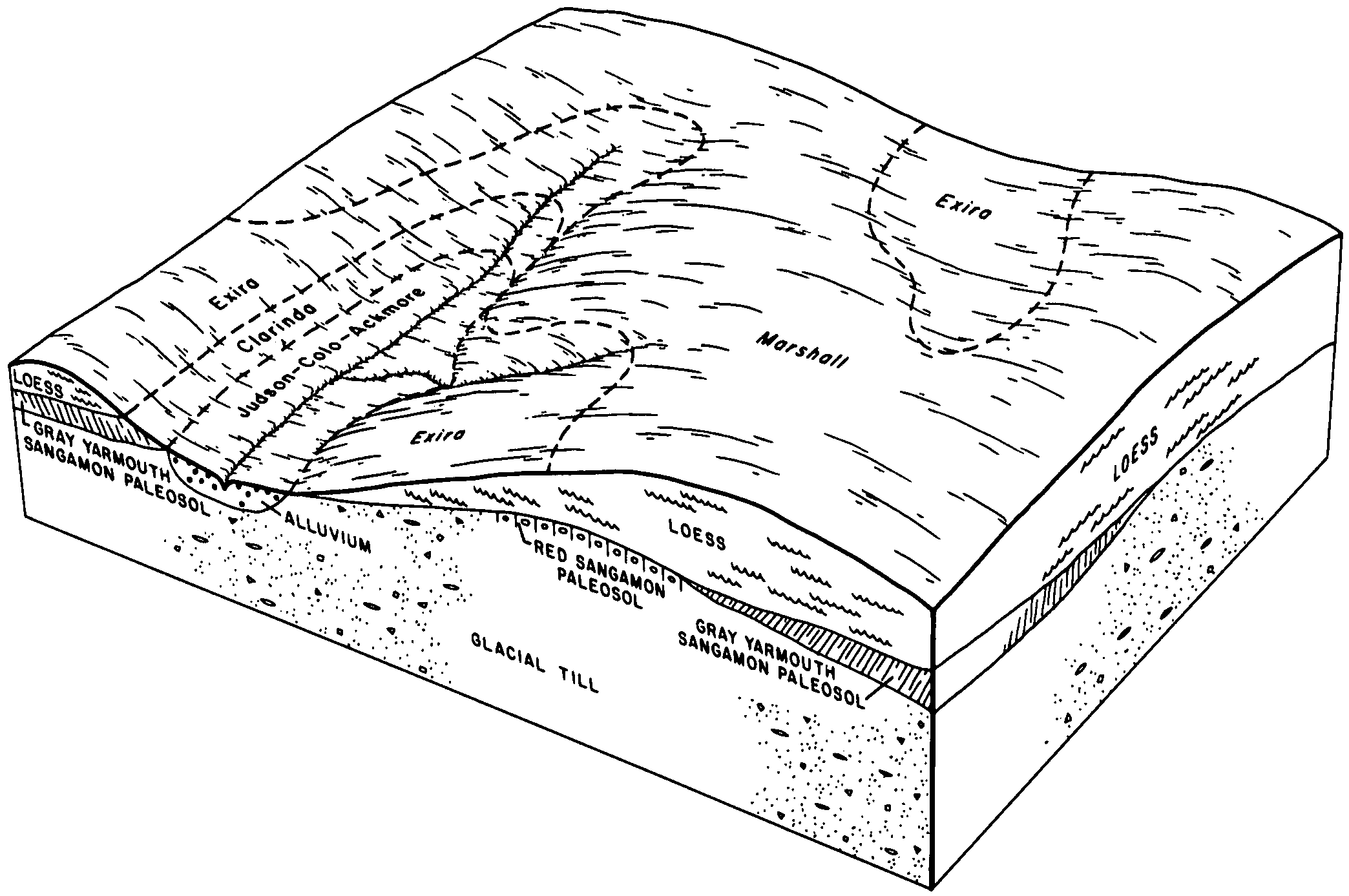
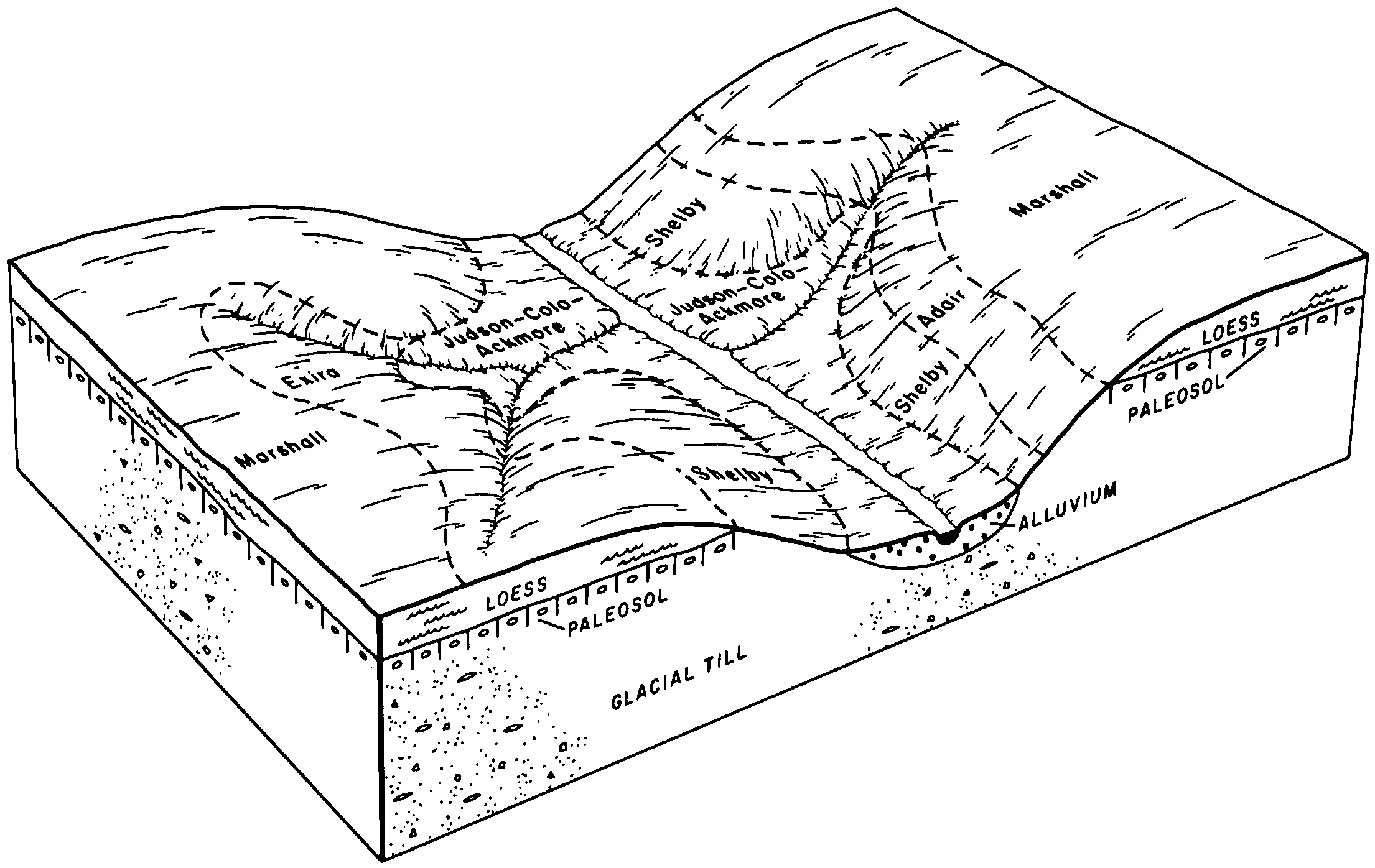
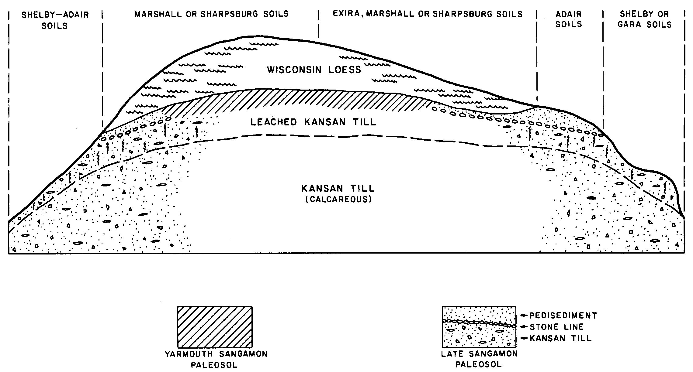
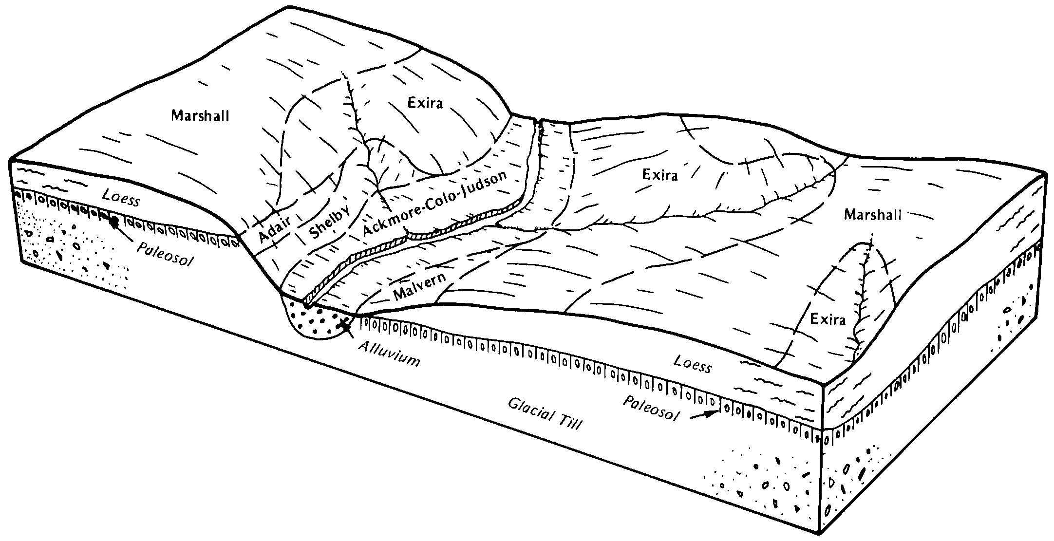
| Exira silty clay loam, 9 to 14 percent slopes, eroded | 99D2 | 18792 | 402795 | 2xbn0 | ia009 | 1982 | 1:15840 |
Exira silty clay loam, 5 to 9 percent slopes, eroded | 99C2 | 5669 | 402794 | 2xbmz | ia009 | 1982 | 1:15840 |
Exira silty clay loam, 14 to 18 percent slopes, eroded | 99E2 | 2410 | 402797 | 2xbmv | ia009 | 1982 | 1:15840 |
Exira silty clay loam, 9 to 14 percent slopes, severely eroded | 99D3 | 1949 | 402796 | 2xbn1 | ia009 | 1982 | 1:15840 |
Exira silty clay loam, 5 to 9 percent slopes, eroded | 99C2 | 17667 | 403577 | 2xbmz | ia027 | 1979 | 1:15840 |
Exira silty clay loam, 9 to 14 percent slopes, eroded | 99D2 | 17563 | 403578 | 2xbn0 | ia027 | 1979 | 1:15840 |
Exira silty clay loam, 14 to 20 percent slopes, eroded | 99E2 | 1251 | 403579 | 2xbmx | ia027 | 1979 | 1:15840 |
Exira silty clay loam, 9 to 14 percent slopes, eroded | 99D2 | 45187 | 2229711 | 2xbn0 | ia029 | 2010 | 1:12000 |
Exira silty clay loam, 14 to 18 percent slopes, eroded | 99E2 | 3918 | 2423006 | 2xbmv | ia029 | 2010 | 1:12000 |
Exira silty clay loam, 9 to 14 percent slopes, severely eroded | 99D3 | 3427 | 2229714 | 2xbn1 | ia029 | 2010 | 1:12000 |
Exira silty clay loam, 14 to 18 percent slopes, severely eroded | 99E3 | 1254 | 2229712 | 2xbmw | ia029 | 2010 | 1:12000 |
Exira silty clay loam, 9 to 14 percent slopes, eroded | 99D2 | 12017 | 399860 | 2xbn0 | ia047 | 2004 | 1:12000 |
Exira silty clay loam, 5 to 9 percent slopes, eroded | 99C2 | 2817 | 399858 | 2xbmz | ia047 | 2004 | 1:12000 |
Exira silty clay loam, 14 to 18 percent slopes, eroded | 99E2 | 1516 | 399862 | 2xbmv | ia047 | 2004 | 1:12000 |
Exira silty clay loam, 9 to 14 percent slopes, eroded | 99D2 | 3989 | 407236 | 2xbn0 | ia093 | 1989 | 1:15840 |
Exira silty clay loam, 9 to 14 percent slopes, severely eroded | 99D3 | 1719 | 407237 | 2xbn1 | ia093 | 1989 | 1:15840 |
Exira silty clay loam, 5 to 9 percent slopes, eroded | 99C2 | 611 | 407234 | 2xbmz | ia093 | 1989 | 1:15840 |
Exira silty clay loam, 14 to 20 percent slopes, eroded | 99E2 | 315 | 407238 | 2xbmx | ia093 | 1989 | 1:15840 |
Exira silty clay loam, 9 to 14 percent slopes, eroded | 99D2 | 17494 | 409603 | 2xbn0 | ia129 | 1979 | 1:15840 |
Exira silty clay loam, 5 to 9 percent slopes, eroded | 99C2 | 3134 | 409601 | 2xbmz | ia129 | 1979 | 1:15840 |
Exira silty clay loam, 9 to 14 percent slopes | 99D | 1963 | 409602 | 2xbn4 | ia129 | 1979 | 1:15840 |
Exira silty clay loam, 5 to 9 percent slopes | 99C | 1537 | 409600 | 2xbn3 | ia129 | 1979 | 1:15840 |
Exira silty clay loam, 9 to 14 percent slopes, severely eroded | 99D3 | 868 | 409604 | 2xbn1 | ia129 | 1979 | 1:15840 |
Exira silty clay loam, 14 to 20 percent slopes, eroded | 99E2 | 240 | 409605 | 2xbmx | ia129 | 1979 | 1:15840 |
Exira silty clay loam, 9 to 14 percent slopes, eroded | 99D2 | 25492 | 409896 | 2xbn0 | ia137 | 1987 | 1:15840 |
Exira silty clay loam, 5 to 9 percent slopes, eroded | 99C2 | 4781 | 409895 | 2xbmz | ia137 | 1987 | 1:15840 |
Exira silty clay loam, 9 to 14 percent slopes, severely eroded | 99D3 | 344 | 409897 | 2xbn1 | ia137 | 1987 | 1:15840 |
Exira silty clay loam, 14 to 18 percent slopes, eroded | 99E2 | 251 | 409898 | 2xbmv | ia137 | 1987 | 1:15840 |
Exira silty clay loam, 9 to 14 percent slopes, eroded | 99D2 | 27205 | 410240 | 2xbn0 | ia145 | 1975 | 1:20000 |
Exira silty clay loam, 9 to 14 percent slopes | 99D | 9003 | 410239 | 2xbn4 | ia145 | 1975 | 1:20000 |
Exira silty clay loam, 5 to 9 percent slopes, eroded | 99C2 | 8913 | 410238 | 2xbmz | ia145 | 1975 | 1:20000 |
Exira silty clay loam, 5 to 9 percent slopes | 99C | 3283 | 410237 | 2xbn3 | ia145 | 1975 | 1:20000 |
Exira silty clay loam, 9 to 14 percent slopes, eroded | 99D2 | 53912 | 410523 | 2xbn0 | ia155 | 1986 | 1:15840 |
Exira silty clay loam, 5 to 9 percent slopes, eroded | 99C2 | 5752 | 410522 | 2xbmz | ia155 | 1986 | 1:15840 |
Exira silty clay loam, 9 to 14 percent slopes, severely eroded | 99D3 | 3289 | 410524 | 2xbn1 | ia155 | 1986 | 1:15840 |
Exira silty clay loam, 14 to 20 percent slopes, eroded | 99E2 | 1456 | 410525 | 2xbmx | ia155 | 1986 | 1:15840 |
Exira silty clay loam, 14 to 20 percent slopes, severely eroded | 99E3 | 1076 | 410526 | 2xbmy | ia155 | 1986 | 1:15840 |
Exira silty clay loam, 9 to 14 percent slopes, eroded | 99D2 | 43283 | 626743 | 2xbn0 | ia165 | 2005 | 1:12000 |
Exira silty clay loam, 14 to 18 percent slopes, eroded | 99E2 | 14688 | 626744 | 2xbmv | ia165 | 2005 | 1:12000 |
Exira silty clay loam, 18 to 25 percent slopes, eroded | 99F2 | 2352 | 780698 | 2xbn2 | ia165 | 2005 | 1:12000 |
Exira silty clay loam, 9 to 14 percent slopes, eroded | 10018 | 16441 | 887503 | 2xbn0 | mo087 | 1992 | 1:24000 |