| Northbend-Ettrick silt loams, 0 to 3 percent slopes, frequently flooded | 1648A | 125 | 3182371 | 2yt2n | il085 | 1990 | 1:12000 |
Northbend-Ettrick silt loams, 0 to 3 percent slopes, frequently flooded | 1648A | 11900 | 2561770 | 2yt2n | wi011 | 1960 | 1:12000 |
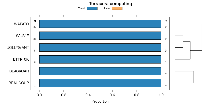
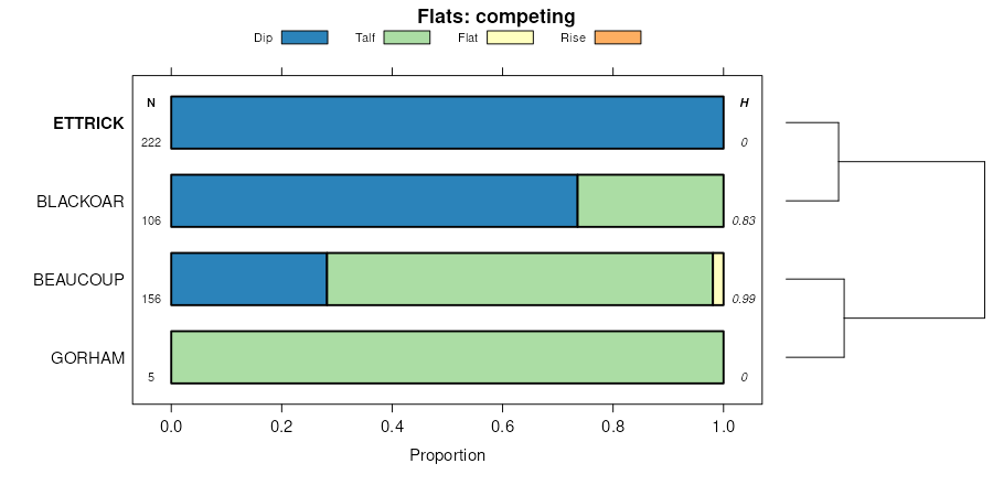
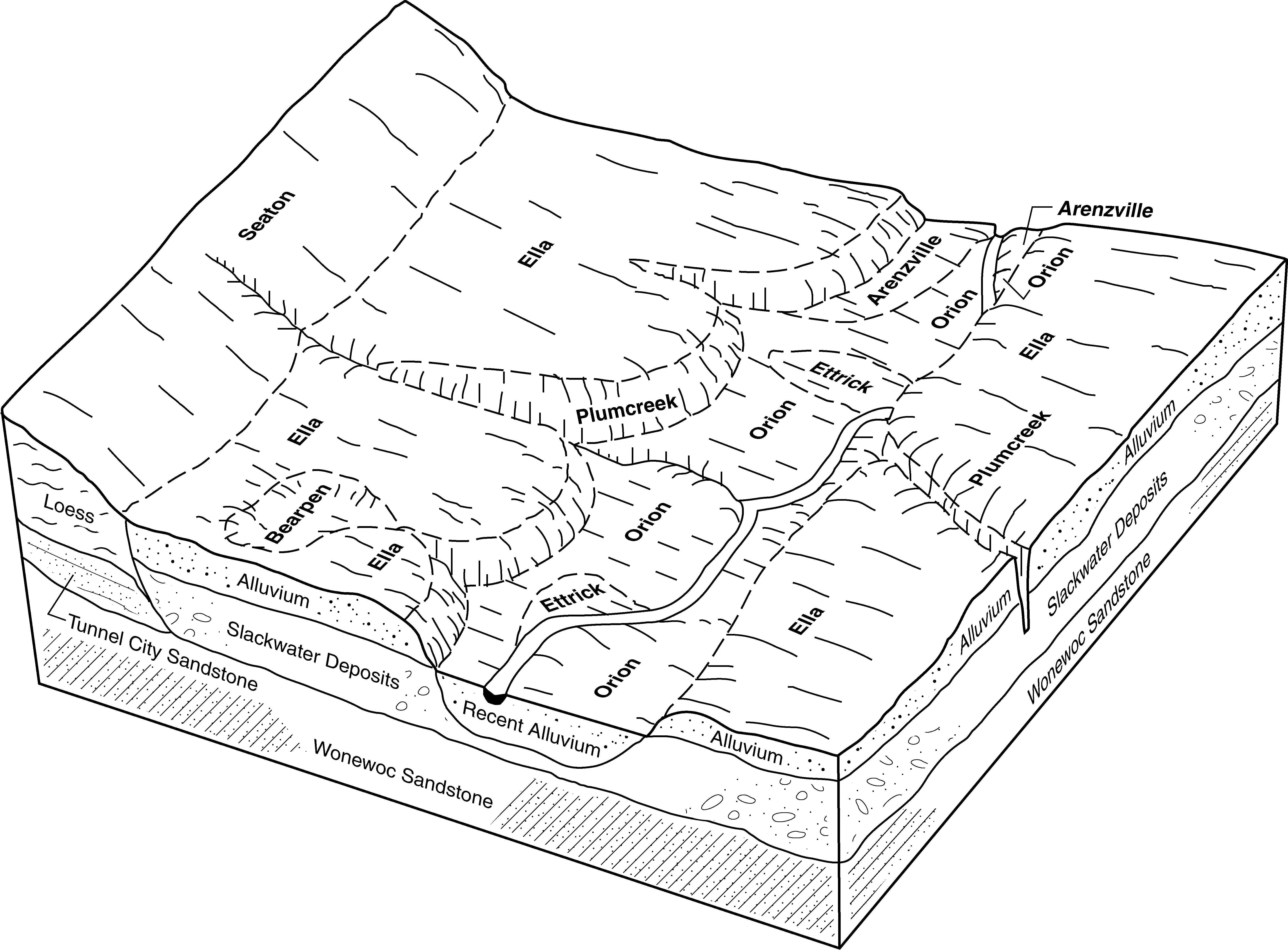
Ettrick silt loam, 0 to 2 percent slopes, frequently flooded | 629A | 3838 | 2561721 | 2wtqy | wi011 | 1960 | 1:12000 |
Ettrick silt loam, shallow, 0 to 2 percent slopes, frequently flooded | 679A | 2597 | 2561722 | 2yt2j | wi011 | 1960 | 1:12000 |
Ettrick silt loam, shallow, 0 to 2 percent slopes, frequently flooded | 679A | 199 | 3053871 | 2yt2j | wi019 | 1994 | 1:20000 |
Northbend-Ettrick silt loams, 0 to 3 percent slopes, frequently flooded | 1648A | 5260 | 2504288 | 2yt2n | wi023 | 1960 | 1:12000 |
Ettrick silt loam, 0 to 2 percent slopes, frequently flooded | 629A | 1863 | 2499034 | 2wtqy | wi023 | 1960 | 1:12000 |
Northbend-Ettrick silt loams, 0 to 3 percent slopes, frequently flooded | 1648A | 1341 | 3182073 | 2yt2n | wi025 | 1972 | 1:15840 |
Ettrick silt loam, 0 to 2 percent slopes, frequently flooded | 629A | 3314 | 2499035 | 2wtqy | wi033 | 2003 | 1:12000 |
Northbend-Ettrick silt loams, 0 to 3 percent slopes, frequently flooded | 1648A | 1685 | 2504289 | 2yt2n | wi033 | 2003 | 1:12000 |
Northbend-Ettrick silt loams, 0 to 3 percent slopes, frequently flooded | 1648A | 2750 | 3099666 | 2yt2n | wi035 | 1974 | 1:12000 |
Ettrick silt loam, 0 to 2 percent slopes, frequently flooded | 629A | 1277 | 421770 | 2wtqy | wi035 | 1974 | 1:12000 |
Ettrick silt loam, shallow, 0 to 2 percent slopes, frequently flooded | 679A | 1169 | 3099730 | 2yt2j | wi035 | 1974 | 1:12000 |
Northbend-Ettrick silt loams, 0 to 3 percent slopes, frequently flooded | 1648A | 874 | 2774763 | 2yt2n | wi043 | 1959 | 1:20000 |
Ettrick silt loam, 0 to 2 percent slopes, frequently flooded | 629A | 332 | 2774759 | 2wtqy | wi043 | 1959 | 1:20000 |
Ettrick silt loam, 0 to 2 percent slopes, frequently flooded | 629A | 2495 | 425248 | 2wtqy | wi045 | 1969 | 1:12000 |
Ettrick silt loam, 0 to 2 percent slopes, frequently flooded | 629A | 5038 | 2806643 | 2wtqy | wi049 | 1960 | 1:20000 |
Northbend-Ettrick silt loams, 0 to 3 percent slopes, frequently flooded | 1648A | 1586 | 2806651 | 2yt2n | wi049 | 1960 | 1:20000 |
Ettrick silt loam, 0 to 2 percent slopes, frequently flooded | 629A | 3723 | 2499036 | 2wtqy | wi053 | 1994 | 1:12000 |
Ettrick silt loam, shallow, 0 to 2 percent slopes, frequently flooded | 679A | 3555 | 2505897 | 2yt2j | wi053 | 1994 | 1:12000 |
Ettrick silt loam, lake terrace, 0 to 2 percent slopes, rarely flooded | 699A | 5943 | 2561532 | 2psw8 | wi057 | 1987 | 1:12000 |
Ettrick silt loam, 0 to 2 percent slopes, frequently flooded | 629A | 4671 | 2561479 | 2wtqy | wi057 | 1987 | 1:12000 |
Ettrick silt loam, shallow, 0 to 2 percent slopes, frequently flooded | 679A | 28 | 3182145 | 2yt2j | wi057 | 1987 | 1:12000 |
Ettrick silt loam, 0 to 2 percent slopes, frequently flooded | 629A | 2346 | 2499037 | 2wtqy | wi063 | 2001 | 1:12000 |
Ettrick silt loam, 0 to 2 percent slopes, frequently flooded | 629A | 512 | 424875 | 2wtqy | wi065 | 1964 | 1:15840 |
Ettrick silt loam, 0 to 2 percent slopes, frequently flooded | 629A | 4319 | 2685078 | 2wtqy | wi081 | 1981 | 1:12000 |
Ettrick silt loam, shallow, 0 to 2 percent slopes, frequently flooded | 679A | 669 | 2685136 | 2yt2j | wi081 | 1981 | 1:12000 |
Ettrick silt loam, lake terrace, 0 to 2 percent slopes, rarely flooded | 699A | 42 | 2685137 | 2psw8 | wi081 | 1981 | 1:12000 |
Northbend-Ettrick silt loams, 0 to 3 percent slopes, frequently flooded | 1648A | 2876 | 2504290 | 2yt2n | wi091 | 1998 | 1:12000 |
Ettrick silt loam, 0 to 2 percent slopes, frequently flooded | 629A | 1030 | 2499038 | 2wtqy | wi091 | 1998 | 1:12000 |
Northbend-Ettrick silt loams, 0 to 3 percent slopes, frequently flooded | 1648A | 1546 | 1693137 | 2yt2n | wi093 | 2006 | 1:12000 |
Ettrick silt loam, 0 to 2 percent slopes, frequently flooded | 629A | 92 | 1691019 | 2wtqy | wi093 | 2006 | 1:12000 |
Northbend-Ettrick silt loams, 0 to 3 percent slopes, frequently flooded | 1648A | 7101 | 2504291 | 2yt2n | wi103 | 2002 | 1:12000 |
Ettrick silt loam, 0 to 2 percent slopes, frequently flooded | 629A | 4067 | 2499039 | 2wtqy | wi103 | 2002 | 1:12000 |
Ettrick silt loam, 0 to 2 percent slopes, frequently flooded | 629A | 15135 | 423150 | 2wtqy | wi111 | 1977 | 1:15840 |
Northbend-Ettrick silt loams, 0 to 3 percent slopes, frequently flooded | 1648A | 7986 | 3182093 | 2yt2n | wi111 | 1977 | 1:15840 |
Ettrick silt loam, shallow, 0 to 2 percent slopes, frequently flooded | 679A | 3197 | 3182096 | 2yt2j | wi111 | 1977 | 1:15840 |
Ettrick silt loam, 0 to 2 percent slopes, frequently flooded | 629A | 13714 | 2639500 | 2wtqy | wi121 | 1969 | 1:12000 |
Northbend-Ettrick silt loams, 0 to 3 percent slopes, frequently flooded | 1648A | 9260 | 2639492 | 2yt2n | wi121 | 1969 | 1:12000 |
Ettrick silt loam, shallow, 0 to 2 percent slopes, frequently flooded | 679A | 2605 | 2639501 | 2yt2j | wi121 | 1969 | 1:12000 |
Ettrick silt loam, 0 to 2 percent slopes, frequently flooded | 629A | 5443 | 2499040 | 2wtqy | wi123 | 1965 | 1:12000 |
Northbend-Ettrick silt loams, 0 to 3 percent slopes, frequently flooded | 1648A | 1897 | 2504292 | 2yt2n | wi123 | 1965 | 1:12000 |