| Estacado loam, 0 to 1 percent slopes | EsA | 2739 | 1547800 | f5sc | nm041 | 2014 | 1:24000 |
Estacado loam, 1 to 3 percent slopes | EsB | 1565 | 1547801 | f5sd | nm041 | 2014 | 1:24000 |
Estacado loam, 0 to 1 percent slopes | EsA | 50750 | 377718 | f5sc | nm669 | 2005 | 1:24000 |
Estacado loam, 1 to 3 percent slopes | EsB | 37712 | 377719 | f5sd | nm669 | 2005 | 1:24000 |
Estacado clay loam, 1 to 3 percent slopes | EcB | 9011 | 2428272 | db38 | tx011 | 1963 | 1:20000 |
Estacado clay loam, 0 to 1 percent slopes | EcA | 1325 | 2428226 | db39 | tx011 | 1963 | 1:20000 |
Estacado clay loam, moist, 0 to 1 percent slopes | EtA | 14979 | 2962339 | 2xrwv | tx033 | 1970 | 1:24000 |
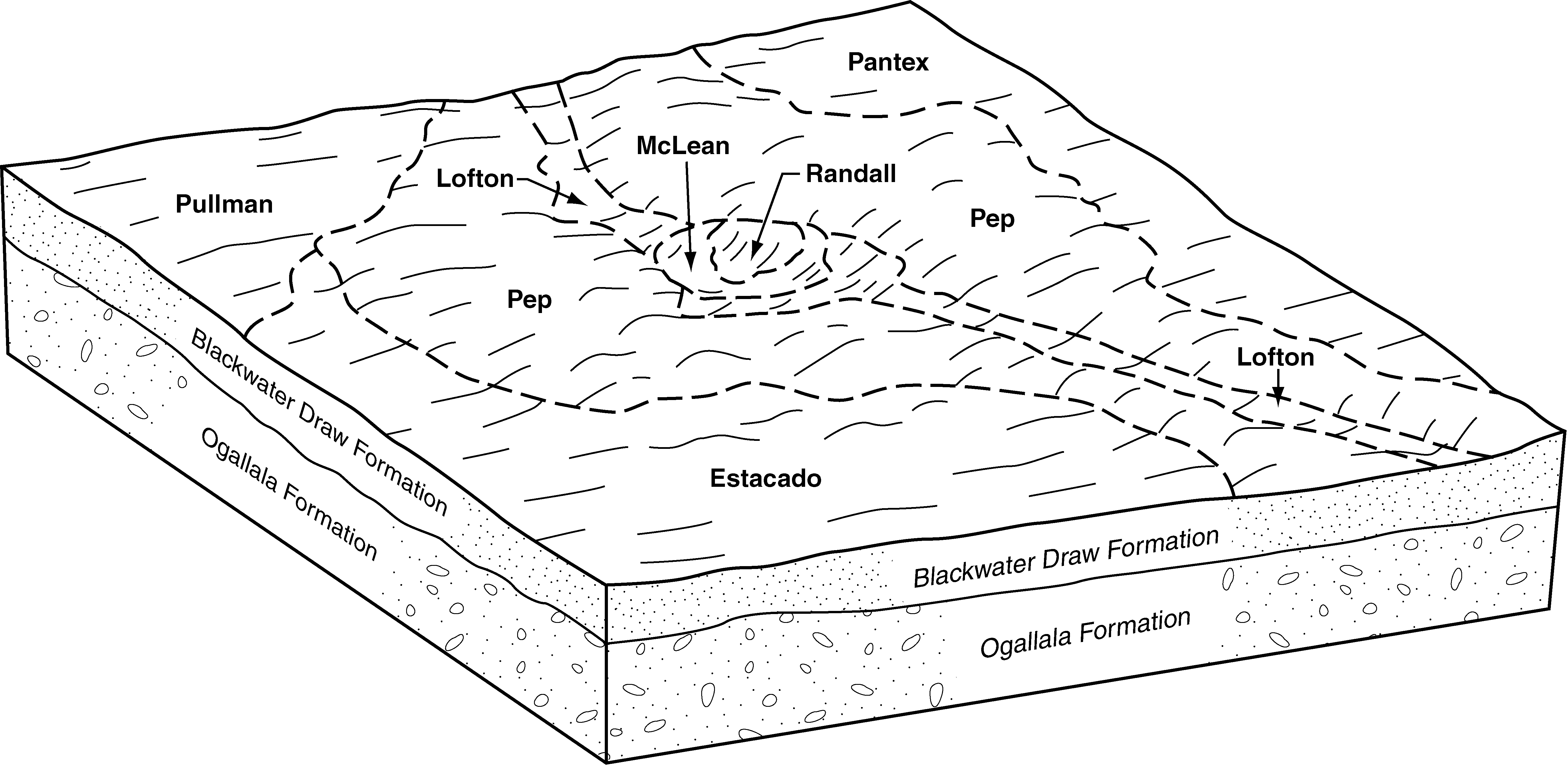
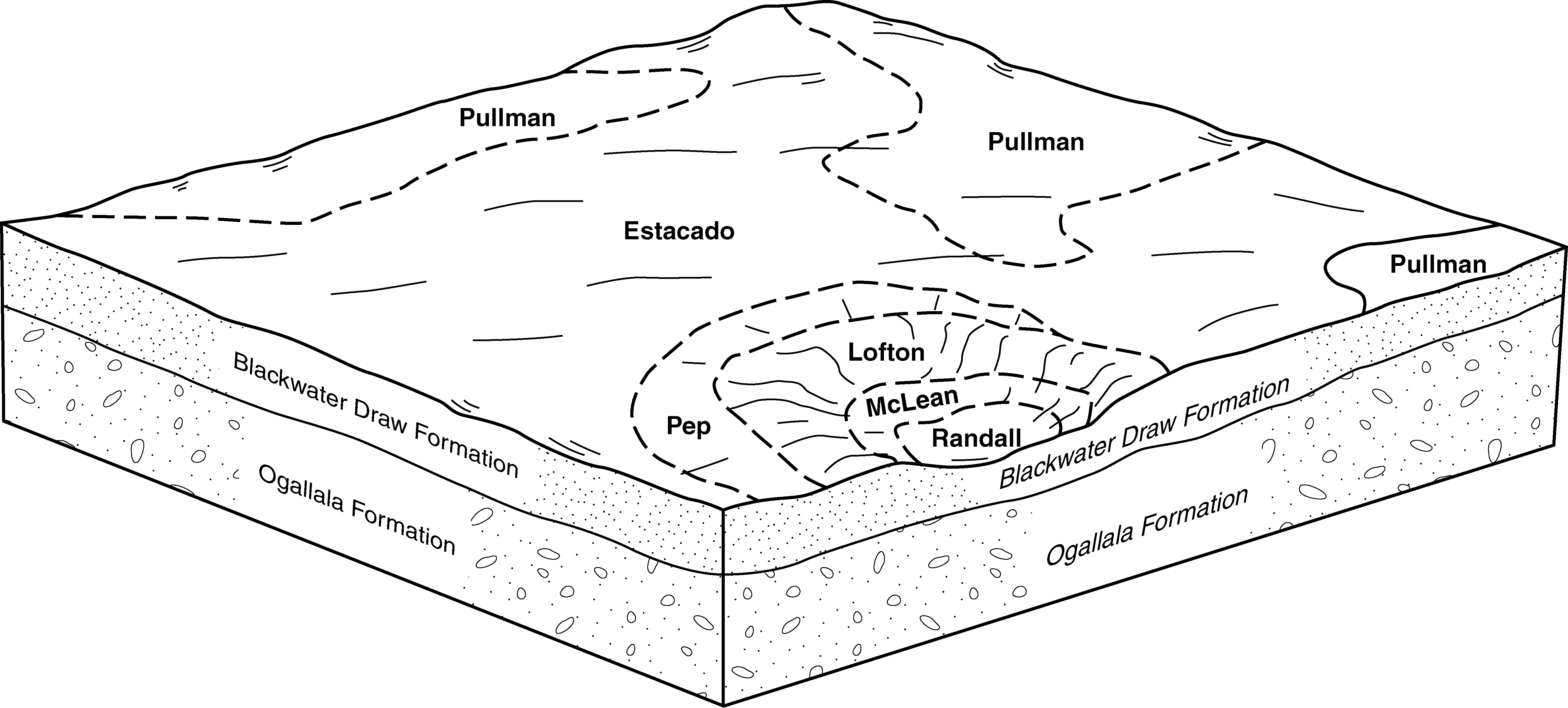
Estacado and Pep loams, 0 to 1 percent slopes | EPA | 11550 | 2962306 | f5sb | tx033 | 1970 | 1:24000 |
Estacado clay loam, moist, 1 to 3 percent slopes | EtB | 4470 | 2962340 | 2xrwx | tx033 | 1970 | 1:24000 |
Estacado loam, 0 to 1 percent slopes | EsA | 4366 | 2962304 | f5sc | tx033 | 1970 | 1:24000 |
Estacado loam, 1 to 3 percent slopes | EsB | 2021 | 2962305 | f5sd | tx033 | 1970 | 1:24000 |
Bovina and Estacado clay loams, 3 to 5 percent slopes | BsC | 1512 | 3258055 | 308q8 | tx045 | 1972 | 1:20000 |
Estacado clay loam, 1 to 3 percent slopes | EcB | 1394 | 363279 | db38 | tx045 | 1972 | 1:20000 |
Estacado clay loam, 0 to 1 percent slopes | EcA | 625 | 363278 | db39 | tx045 | 1972 | 1:20000 |
Estacado clay loam, 1 to 3 percent slopes | EcB | 26885 | 377948 | db38 | tx065 | 2000 | 1:24000 |
Estacado clay loam, 0 to 1 percent slopes | EcA | 6281 | 377947 | db39 | tx065 | 2000 | 1:24000 |
Estacado clay loam, 0 to 1 percent slopes | EcA | 29562 | 2428277 | db39 | tx069 | 1969 | 1:20000 |
Estacado clay loam, 1 to 3 percent slopes | EcB | 29380 | 2428278 | db38 | tx069 | 1969 | 1:20000 |
Pep-Estacado loams, 3 to 5 percent slopes | MeC | 8785 | 363769 | d6jh | tx069 | 1969 | 1:20000 |
Estacado loam, 1 to 3 percent slopes | EsB | 2395 | 363765 | f5sd | tx069 | 1969 | 1:20000 |
Estacado loam, 0 to 1 percent slopes | EsA | 1755 | 363764 | f5sc | tx069 | 1969 | 1:20000 |
Estacado loam, 0 to 1 percent slopes | EsA | 312 | 2931515 | f5sc | tx079 | 1962 | 1:20000 |
Estacado and Pep loams, 0 to 1 percent slopes | EPA | 9029 | 393607 | f5sb | tx115 | 2004 | 1:24000 |
Estacado loam, 0 to 1 percent slopes | EsA | 5128 | 393609 | f5sc | tx115 | 2004 | 1:24000 |
Estacado loam, 1 to 3 percent slopes | EsB | 735 | 393608 | f5sd | tx115 | 2004 | 1:24000 |
Estacado clay loam, 0 to 1 percent slopes | EcA | 53500 | 378048 | db39 | tx117 | 1999 | 1:24000 |
Estacado clay loam, 1 to 3 percent slopes | EcB | 1643 | 365171 | db38 | tx129 | 1975 | 1:24000 |
Estacado clay loam, 0 to 1 percent slopes | EcA | 1145 | 365170 | db39 | tx129 | 1975 | 1:24000 |
Estacado clay loam, 1 to 3 percent slopes | EcB | 12572 | 644648 | db38 | tx153 | 2004 | 1:24000 |
Estacado clay loam, 0 to 1 percent slopes | EcA | 4453 | 644647 | db39 | tx153 | 2004 | 1:24000 |
Estacado clay loam, 3 to 5 percent slopes | EcC | 1125 | 1381232 | 1t1zg | tx153 | 2004 | 1:24000 |
Estacado clay loam, 0 to 1 percent slopes | EsA | 1092 | 366238 | db39 | tx173 | 1974 | 1:31680 |
Estacado clay loam, 1 to 3 percent slopes | PcB | 6061 | 391944 | db38 | tx179 | 1965 | 1:20000 |
Estacado clay loam, 0 to 1 percent slopes | PcA | 1361 | 391943 | db39 | tx179 | 1965 | 1:20000 |
Estacado loam, 1 to 3 percent slopes | EsB | 16147 | 366904 | f5sd | tx189 | 1969 | 1:20000 |
Estacado loam, 0 to 1 percent slopes | EsA | 10987 | 366903 | f5sc | tx189 | 1969 | 1:20000 |
Estacado loam, 0 to 1 percent slopes | EsA | 8779 | 378979 | f5sc | tx219 | 1999 | 1:24000 |
Estacado silty clay loam, 1 to 3 percent slopes | EsB | 15615 | 369452 | ddft | tx295 | 1971 | 1:24000 |
Estacado-Olton complex, 0 to 3 percent slopes | EtB | 5208 | 369453 | ddfv | tx295 | 1971 | 1:24000 |
Estacado clay loam, 0 to 1 percent slopes | EcA | 42593 | 369837 | db39 | tx303 | 1975 | 1:20000 |
Estacado clay loam, 1 to 3 percent slopes | EcB | 12012 | 369838 | db38 | tx303 | 1975 | 1:20000 |
Estacado-Urban land complex, 0 to 3 percent slopes | EcU | 3752 | 369840 | plf2 | tx303 | 1975 | 1:20000 |
Estacado and Pep loams, 0 to 1 percent slopes | EPA | 22518 | 379037 | f5sb | tx305 | 1999 | 1:24000 |
Estacado loam, 0 to 1 percent slopes | EsA | 9134 | 379038 | f5sc | tx305 | 1999 | 1:24000 |
Estacado loam, 1 to 3 percent slopes | EsB | 5841 | 379039 | f5sd | tx305 | 1999 | 1:24000 |
Estacado clay loam, breaks, 1 to 3 percent slopes | EbB | 10471 | 3124182 | 2yk7y | tx359 | 1978 | 1:24000 |
Estacado clay loam, 1 to 3 percent slopes | EcB | 5759 | 3124139 | db38 | tx359 | 1978 | 1:24000 |
Estacado clay loam, 0 to 1 percent slopes | EcA | 5406 | 3124138 | db39 | tx359 | 1978 | 1:24000 |
Estacado clay loam, breaks, 0 to 1 percent slopes | EbA | 2012 | 3124181 | 2yk7x | tx359 | 1978 | 1:24000 |
Estacado clay loam, 1 to 3 percent slopes | EcB | 6326 | 2599111 | db38 | tx369 | 1973 | 1:24000 |
Estacado clay loam, 0 to 1 percent slopes | EcA | 3796 | 2599112 | db39 | tx369 | 1973 | 1:24000 |
Estacado loam, 1 to 3 percent slopes | EsB | 3617 | 2599127 | f5sd | tx369 | 1973 | 1:24000 |
Estacado loam, 0 to 1 percent slopes | EsA | 2698 | 2599126 | f5sc | tx369 | 1973 | 1:24000 |
Estacado clay loam, 3 to 5 percent slopes | EcC | 401 | 2599151 | 1t1zg | tx369 | 1973 | 1:24000 |
Estacado clay loam, breaks, 1 to 3 percent slopes | EbB | 8779 | 3124274 | 2yk7y | tx375 | 1974 | 1:24000 |
Estacado clay loam, 1 to 3 percent slopes | EcB | 1574 | 3124252 | db38 | tx375 | 1974 | 1:24000 |
Estacado clay loam, 0 to 1 percent slopes | EcA | 466 | 3124251 | db39 | tx375 | 1974 | 1:24000 |
Estacado clay loam, breaks, 0 to 1 percent slopes | EbA | 450 | 3124273 | 2yk7x | tx375 | 1974 | 1:24000 |
Estacado clay loam, 1 to 3 percent slopes | EcB | 40707 | 394470 | db38 | tx381 | 1999 | 1:24000 |
Estacado clay loam, 0 to 1 percent slopes | EcA | 18639 | 394468 | db39 | tx381 | 1999 | 1:24000 |
Estacado-Urban land complex, 0 to 3 percent slopes | EcU | 1037 | 643359 | plf2 | tx381 | 1999 | 1:24000 |
Estacado clay loam, 1 to 3 percent slopes | EcB | 12566 | 371512 | db38 | tx393 | 1979 | 1:24000 |
Estacado clay loam, 0 to 1 percent slopes | EcA | 796 | 371511 | db39 | tx393 | 1979 | 1:24000 |
Mansker and Estacado soils, 1 to 3 percent slopes | MeB | 24965 | 372338 | dhfx | tx437 | 1970 | 1:20000 |
Mansker and Estacado soils, 0 to 1 percent slopes | MeA | 14463 | 372337 | dhfw | tx437 | 1970 | 1:20000 |
Estacado clay loam, 1 to 3 percent slopes | EcB | 723 | 2428334 | db38 | tx437 | 1970 | 1:20000 |
Estacado clay loam, 0 to 1 percent slopes | EcA | 313 | 2428333 | db39 | tx437 | 1970 | 1:20000 |
Estacado loam, 0 to 1 percent slopes | EsA | 1194 | 372548 | f5sc | tx445 | 1999 | 1:24000 |
Estacado loam, 1 to 3 percent slopes | EsB | 2377 | 372741 | dhvx | tx451 | 1971 | 1:20000 |
Estacado loam, 0 to 1 percent slopes | EsA | 1532 | 372740 | dhvw | tx451 | 1971 | 1:20000 |