| Enders gravelly fine sandy loam, 10 to 15 percent slopes | EnD | 393 | 523321 | kkkb | al015 | 1959 | 1:20000 |
Enders gravelly fine sandy loam, 6 to 10 percent slopes , eroded | EnC2 | 368 | 523320 | kkk9 | al015 | 1959 | 1:20000 |
Enders gravelly fine sandy loam, 2 to 6 percent slopes eroded | EnB2 | 208 | 523319 | kkk8 | al015 | 1959 | 1:20000 |
Enders and albertville soils, shallow, 10 to 15 percent slopes, eroded | EsD2 | 7637 | 328899 | c17n | al043 | 1960 | 1:20000 |
Enders and albertville soils, shallow, 6 to 10 percent slopes, eroded | EsC2 | 4354 | 328896 | c17k | al043 | 1960 | 1:20000 |
Enders and albertville silty clay loams, shallow, 10 to 15 percent slopes, severely eroded | ErD3 | 2377 | 328894 | c17h | al043 | 1960 | 1:20000 |
Enders (Townley) silt loam, 2 to 6 percent slopes, eroded | EnB2 | 2016 | 328891 | 2ykf6 | al043 | 1960 | 1:20000 |
Enders (Townley) silt loam, 6 to 10 percent slopes, eroded | EnC2 | 1310 | 328892 | 2ykf4 | al043 | 1960 | 1:20000 |
Enders and albertville silty clay loams, shallow, 6 to 10 percent slopes, severely eroded | ErC3 | 1303 | 328893 | c17g | al043 | 1960 | 1:20000 |
Enders and albertville soils, shallow, 2 to 6 percent slopes, eroded | EsB2 | 988 | 328895 | c17j | al043 | 1960 | 1:20000 |
Enders and albertville soils, shallow, 10 to 15 percent slopes | EsD | 704 | 328898 | c17m | al043 | 1960 | 1:20000 |
Enders and Muse soils, 6 to 15 percent slopes, severely eroded | EsC3 | 597 | 328897 | c17l | al043 | 1960 | 1:20000 |
Enders loam, 6 to 10 percent slopes, moderately eroded | EdC2 | 5138 | 329453 | 318dn | al057 | 1963 | 1:15840 |
Enders loam, 2 to 6 percent slopes, eroded | EdB2 | 4237 | 329451 | c1tg | al057 | 1963 | 1:15840 |
Enders loam, 6 to 10 percent slopes | EdC | 2528 | 329452 | 318dm | al057 | 1963 | 1:15840 |
Enders clay loam, 6 to 10 percent slopes, severely eroded | EcC3 | 1258 | 329448 | c1tc | al057 | 1963 | 1:15840 |
Enders loam, 2 to 6 percent slopes | EdB | 516 | 329450 | 2ykdy | al057 | 1963 | 1:15840 |
Enders loam, 10 to 15 percent slopes, moderately eroded | EdD2 | 471 | 329455 | 318dl | al057 | 1963 | 1:15840 |
Enders clay loam, 2 to 6 percent slopes, severely eroded | EcB3 | 349 | 329447 | c1tb | al057 | 1963 | 1:15840 |
Enders clay loam, 10 to 15 percent slopes, severely eroded | EcD3 | 349 | 329449 | c1td | al057 | 1963 | 1:15840 |
Enders loam, 10 to 15 percent slopes | EdD | 348 | 329454 | 318dk | al057 | 1963 | 1:15840 |
Enders (Albertville) silt loam, 2 to 5 percent slopes | Edu | 2337 | 522864 | 2zpq6 | al071 | 1943 | 1:24000 |
Enders (Albertville) silt loam, 5 to 10 percent slopes | Edo | 2233 | 522863 | 2zn17 | al071 | 1943 | 1:24000 |
Enders (Albertville) silt loam, 5 to 10 percent slopes, eroded | Edn | 1509 | 522862 | 2ykf3 | al071 | 1943 | 1:24000 |
Enders (Albertville) silt loam, 2 to 5 percent slopes, eroded | Ede | 485 | 522860 | 2ykf5 | al071 | 1943 | 1:24000 |
Enders (Townley) silt loam, 5 to 10 percent slopes, eroded, shallow | Eda | 422 | 522859 | 2zjxp | al071 | 1943 | 1:24000 |
Enders (Townley) silt loam, 5 to 10 percent slopes, shallow | Edg | 203 | 522861 | 2zjxn | al071 | 1943 | 1:24000 |
Enders loam, 5 to 12 percent slopes | Ec | 13622 | 330116 | 2ykf0 | al079 | 1950 | 1:20000 |
Enders loam, 5 to 12 percent slopes, eroded | Ea | 2064 | 330114 | 2ykdz | al079 | 1950 | 1:20000 |
Enders loam, 2 to 5 percent slopes, eroded | Eb | 438 | 330115 | 2ykdx | al079 | 1950 | 1:20000 |
Enders (Townley) loam, 5 to 10 percent slopes, eroded | Eb | 8267 | 331069 | 2ykf1 | al103 | 1949 | 1:15840 |
Enders (Townley) loam, 5 to 10 percent slopes | Ed | 3127 | 331071 | 2ykf2 | al103 | 1949 | 1:15840 |
Enders loam, 2 to 5 percent slopes, eroded | Ec | 2084 | 331070 | 2ykdx | al103 | 1949 | 1:15840 |
Enders loam, 2 to 5 percent slopes | Ee | 1319 | 331072 | 2zpq7 | al103 | 1949 | 1:15840 |
Enders-Montevallo association, steep | EmE | 3356 | 523234 | kkgj | al121 | 1969 | 1:20000 |
Enders-Townley-Montevallo complex, 6 to 15 percent slopes | EtD | 1432 | 523235 | kkgk | al121 | 1969 | 1:20000 |
Enders very stony loam, 12 to 30 percent slopes | EoF | 1949 | 565030 | 2s1y9 | ar007 | 1973 | 1:20000 |
Enders very gravelly loam, 3 to 12 percent slopes | EnD | 1648 | 565028 | lyyq | ar007 | 1973 | 1:20000 |
Enders very stony loam, 3 to 12 percent slopes | EoD | 681 | 565029 | 2s1y8 | ar007 | 1973 | 1:20000 |
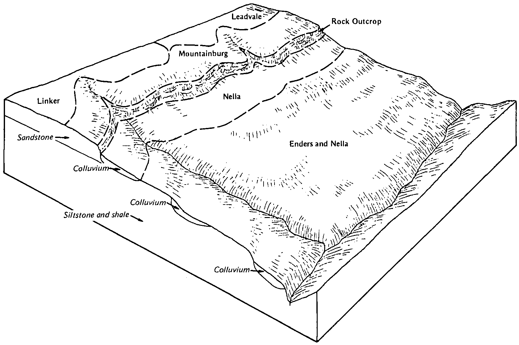
Enders-Nella complex, 8 to 20 percent slopes | 16 | 10527 | 565101 | 2s1yb | ar009 | 1977 | 1:20000 |
Enders-Nella complex, 20 to 40 percent slopes | 17 | 6387 | 565102 | 2rxhf | ar009 | 1977 | 1:20000 |
Enders gravelly loam, 3 to 8 percent slopes | 15 | 2025 | 565100 | 2rxhb | ar009 | 1977 | 1:20000 |
Enders-Leesburg complex, 8 to 20 percent slopes | 14 | 17920 | 565218 | 2rxhc | ar015 | 1981 | 1:20000 |
Enders-Mountainburg association, 20 to 40 percent slopes | 15 | 7350 | 565219 | 2s1yv | ar015 | 1981 | 1:20000 |
Enders gravelly loam, 3 to 8 percent slopes | 12 | 2430 | 565216 | 2rxhb | ar015 | 1981 | 1:20000 |
Enders gravelly loam, 8 to 15 percent slopes | 13 | 1320 | 565217 | 2s1yn | ar015 | 1981 | 1:20000 |
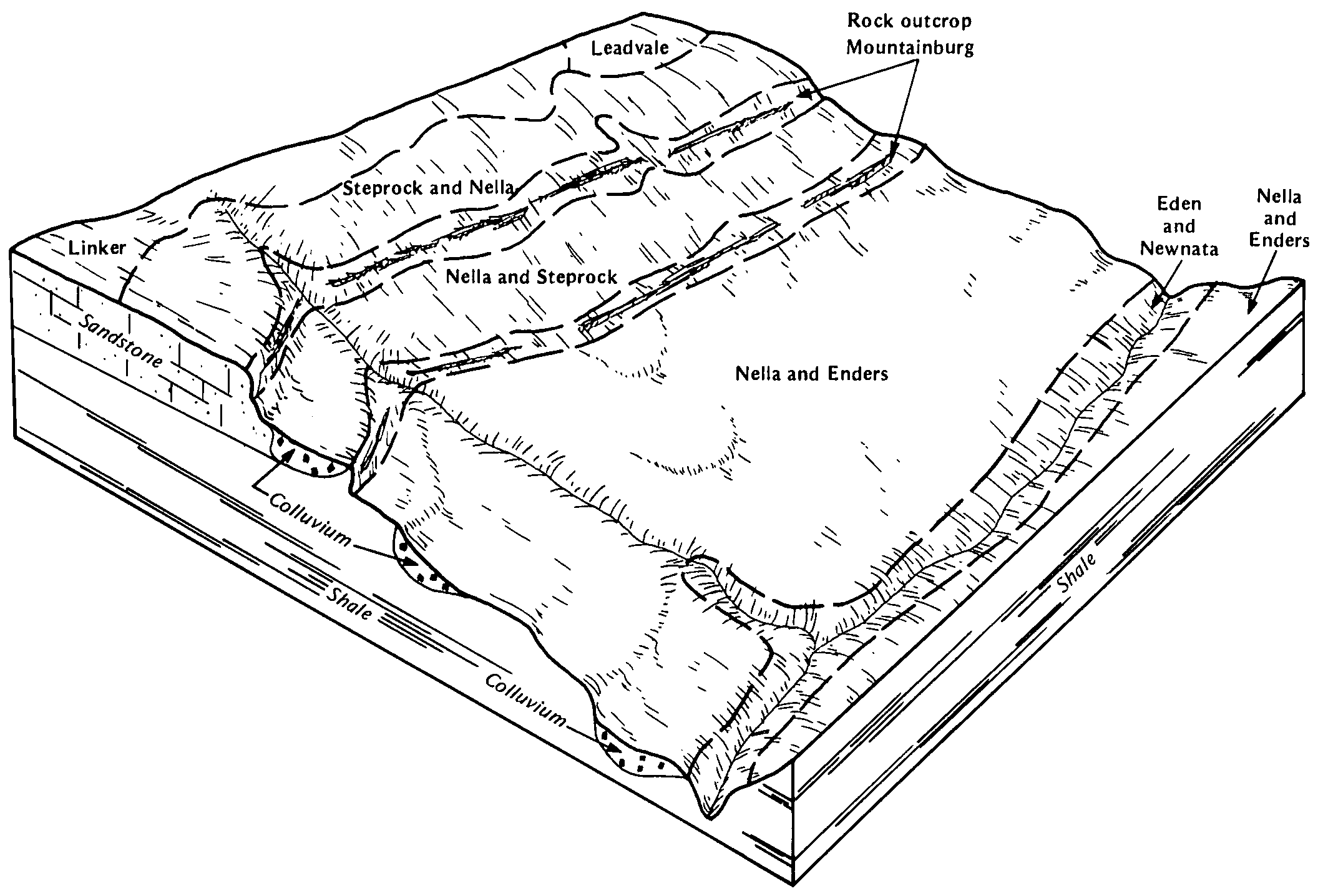
Enders-Steprock complex, 8 to 20 percent slopes | 9 | 34080 | 3086063 | 2s1xz | ar023 | 1983 | 1:20000 |
Enders-Nella-Steprock complex, 8 to 20 percent slopes | 7 | 14429 | 3086061 | 2s1y2 | ar023 | 1983 | 1:20000 |
Enders-Steprock complex, 20 to 40 percent slopes | 10 | 13105 | 3086031 | 2s1y0 | ar023 | 1983 | 1:20000 |
Enders gravelly fine sandy loam, 3 to 8 percent slopes | 4 | 7865 | 3086058 | 30x8d | ar023 | 1983 | 1:20000 |
Enders-Nella-Steprock complex, 20 to 40 percent slopes | 8 | 5190 | 3086062 | 2s1y3 | ar023 | 1983 | 1:20000 |
Enders stony fine sandy loam, 8 to 15 percent slopes | 6 | 3325 | 3086060 | 30x8m | ar023 | 1983 | 1:20000 |
Enders gravelly fine sandy loam, 8 to 12 percent slopes | 5 | 1370 | 3086059 | 30x8h | ar023 | 1983 | 1:20000 |
Enders gravelly fine sandy loam, 12 to 45 percent slopes | 10 | 11523 | 565376 | 30x8g | ar029 | 1977 | 1:20000 |
Enders gravelly fine sandy loam, 8 to 12 percent slopes | 9 | 8353 | 565410 | 2s1yd | ar029 | 1977 | 1:20000 |
Enders gravelly fine sandy loam, 3 to 8 percent slopes | 8 | 7890 | 565409 | 2s1yf | ar029 | 1977 | 1:20000 |
Enders gravelly fine sandy loam, 1 to 3 percent slopes | 7 | 588 | 565408 | 30x8n | ar029 | 1977 | 1:20000 |
Nella-Enders complex, 20 to 40 percent slopes | 22 | 112382 | 565426 | 2y1kt | ar033 | 1975 | 1:20000 |
Enders stony fine sandy loam, 12 to 50 percent slopes | 7 | 42884 | 565439 | 2s1yp | ar033 | 1975 | 1:20000 |
Enders gravelly fine sandy loam, 8 to 20 percent slopes | 6 | 30705 | 565438 | 30x8q | ar033 | 1975 | 1:20000 |
Nella-Enders association, very steep | 23 | 11838 | 565427 | lzcl | ar033 | 1975 | 1:20000 |
Enders-Mountainburg association, 8 to 20 percent slopes | 8 | 7738 | 565440 | 2s1yt | ar033 | 1975 | 1:20000 |
Enders-Mountainburg association, 20 to 40 percent slopes | 9 | 4233 | 565441 | 2s1yv | ar033 | 1975 | 1:20000 |
Enders fine sandy loam, 3 to 8 percent slopes | 5 | 3218 | 565437 | 2s1yq | ar033 | 1975 | 1:20000 |
Nella-Enders complex, 8 to 20 percent slopes | 21 | 2097 | 565425 | 2y1kw | ar033 | 1975 | 1:20000 |
Enders gravelly fine sandy loam, 12 to 45 percent slopes | 5 | 15542 | 565512 | 30x8g | ar045 | 1975 | 1:20000 |
Enders gravelly fine sandy loam, 8 to 12 percent slopes | 4 | 9929 | 565511 | 30x8h | ar045 | 1975 | 1:20000 |
Enders gravelly fine sandy loam, 3 to 8 percent slopes | 3 | 5577 | 565506 | 30x8d | ar045 | 1975 | 1:20000 |
Allen-Enders association, steep, (nella) | AEE | 24282 | 565522 | lzgn | ar047 | 1967 | 1:20000 |
Allen-Enders association, rolling, (nella) | AED | 15414 | 565521 | lzgm | ar047 | 1967 | 1:20000 |
Enders-Mountainburg association, 20 to 40 percent slopes | EME | 11397 | 565541 | 2s1yv | ar047 | 1967 | 1:20000 |
Allen-Enders association, very steep, (nella) | AEF | 5494 | 565523 | lzgp | ar047 | 1967 | 1:20000 |
Enders-Mountainburg association, 8 to 20 percent slopes | EMD | 5460 | 565540 | 2s1yt | ar047 | 1967 | 1:20000 |
Holston-Enders association, very steep, (nella, enders) | HOF | 3636 | 565555 | lzhq | ar047 | 1967 | 1:20000 |
Holston-Enders association, steep, (nella, enders) | HOE | 2753 | 565554 | lzhp | ar047 | 1967 | 1:20000 |
Enders gravelly silt loam, 8 to 20 percent slopes, eroded | EnD2 | 2567 | 565543 | 2s1yh | ar047 | 1967 | 1:20000 |
Enders gravelly silt loam, 3 to 8 percent slopes, eroded | EnC2 | 1850 | 565542 | 2s1yj | ar047 | 1967 | 1:20000 |
Enders stony fine sandy loam, 12 to 50 percent slopes | EsF | 1420 | 565544 | 2s1yp | ar047 | 1967 | 1:20000 |
Holston-Enders association, rolling, (nella, enders) | HOD | 1251 | 565553 | lzhn | ar047 | 1967 | 1:20000 |
Enders stony fine sandy loam, 20 to 45 percent slopes | 22 | 29159 | 565742 | 2s1yg | ar063 | 1980 | 1:20000 |
Enders stony fine sandy loam, 8 to 20 percent slopes | 21 | 12268 | 565741 | 2s1yc | ar063 | 1980 | 1:20000 |
Enders fine sandy loam, 8 to 12 percent slopes | 20 | 6014 | 565740 | 2s1ym | ar063 | 1980 | 1:20000 |
Enders fine sandy loam, 3 to 8 percent slopes | 19 | 3600 | 565738 | 2s1yq | ar063 | 1980 | 1:20000 |
Enders stony silt loam, 12 to 25 percent slopes | EsE | 2957 | 565805 | lzrs | ar067 | 1971 | 1:20000 |
Enders silt loam, 3 to 12 percent slopes | EnD | 1229 | 565804 | 30x8v | ar067 | 1971 | 1:20000 |
Nella-Enders complex, 20 to 40 percent slopes | NEE | 53590 | 565855 | 2y1kt | ar071 | 1973 | 1:24000 |
Nella-Enders complex, 8 to 20 percent slopes | NED | 16111 | 565854 | 2y1kw | ar071 | 1973 | 1:24000 |
Nella-Enders association, very steep | NEF | 10836 | 565856 | lztf | ar071 | 1973 | 1:24000 |
Leesburg-Enders association, very steep | LEF | 8014 | 565835 | lzsr | ar071 | 1973 | 1:24000 |
Leesburg-Enders association, steep | LEE | 3060 | 565834 | lzsq | ar071 | 1973 | 1:24000 |
Mountainburg-Enders association, steep | MEE | 2920 | 565844 | lzt1 | ar071 | 1973 | 1:24000 |
Enders gravelly fine sandy loam, 5 to 15 percent slopes | EnD | 2825 | 565830 | 30x8p | ar071 | 1973 | 1:24000 |
Enders-Mountainburg association, 8 to 20 percent slopes | EMD | 2333 | 565828 | 2s1yt | ar071 | 1973 | 1:24000 |
Enders-Mountainburg association, 20 to 40 percent slopes | EME | 2135 | 565829 | 2s1yv | ar071 | 1973 | 1:24000 |
Mountainburg-Enders association, rolling | MED | 2083 | 565843 | lzt0 | ar071 | 1973 | 1:24000 |
Mountainburg-Enders association, very steep | MEF | 806 | 565845 | lzt2 | ar071 | 1973 | 1:24000 |
Enders-Mountainburg complex, 20 to 40 percent slopes | 14 | 53320 | 565877 | 2xhyv | ar083 | 1977 | 1:20000 |
Enders stony silt loam, 12 to 45 percent slopes | 12 | 36739 | 565875 | lzv1 | ar083 | 1977 | 1:20000 |
Enders gravelly silt loam, 8 to 20 percent slopes | 10 | 32103 | 565873 | 30x8k | ar083 | 1977 | 1:20000 |
Nella-Enders complex, 20 to 40 percent slopes | 28 | 21584 | 565892 | 2y1kv | ar083 | 1977 | 1:20000 |
Enders-Mountainburg complex, 8 to 20 percent slopes | 13 | 18125 | 565876 | 2xhyw | ar083 | 1977 | 1:20000 |
Nella-Enders complex, 8 to 20 percent slopes | 27 | 16893 | 565891 | 2y1ks | ar083 | 1977 | 1:20000 |
Enders silt loam, 8 to 20 percent slopes | 8 | 7323 | 565905 | 30x8t | ar083 | 1977 | 1:20000 |
Enders silt loam, 3 to 8 percent slopes | 7 | 6104 | 565904 | 30x8f | ar083 | 1977 | 1:20000 |
Enders gravelly silt loam, 3 to 8 percent slopes | 9 | 3280 | 565906 | 30x8j | ar083 | 1977 | 1:20000 |
Enders gravelly silt loam, 20 to 45 percent slopes | 11 | 849 | 565874 | 30x8r | ar083 | 1977 | 1:20000 |
Enders-Leesburg complex, 8 to 20 percent slopes | 15 | 101191 | 565914 | 2rxhc | ar087 | 1982 | 1:20000 |
Enders-Leesburg complex, 20 to 40 percent slopes | 16 | 94325 | 565915 | 2rxhd | ar087 | 1982 | 1:20000 |
Enders stony loam, 3 to 15 percent slopes | 14 | 14202 | 565913 | 2s1yr | ar087 | 1982 | 1:20000 |
Enders gravelly loam, 3 to 8 percent slopes | 12 | 3146 | 565911 | 2rxhb | ar087 | 1982 | 1:20000 |
Enders gravelly loam, 8 to 15 percent slopes | 13 | 2291 | 565912 | 2s1yn | ar087 | 1982 | 1:20000 |
Nella-Enders complex, 8 to 20 percent slopes | 35 | 52524 | 566017 | 2y1kw | ar101 | 1984 | 1:20000 |
Nella-Enders stony loams, 20 to 40 percent slopes | 36 | 35718 | 566018 | lzzn | ar101 | 1984 | 1:20000 |
Enders-Leesburg complex, 8 to 20 percent slopes | 15 | 27478 | 565995 | 2rxhc | ar101 | 1984 | 1:20000 |
Enders-Leesburg complex, 20 to 40 percent slopes | 16 | 14076 | 565996 | 2rxhd | ar101 | 1984 | 1:20000 |
Enders stony loam, 3 to 15 percent slopes | 13 | 13456 | 565993 | 2s1yr | ar101 | 1984 | 1:20000 |
Enders gravelly loam, 8 to 15 percent slopes | 12 | 5365 | 565992 | 2s1yn | ar101 | 1984 | 1:20000 |
Enders gravelly loam, 3 to 8 percent slopes | 11 | 4626 | 565991 | 2rxhb | ar101 | 1984 | 1:20000 |
Enders stony loam, 15 to 40 percent slopes | 14 | 3710 | 565994 | 2s1xw | ar101 | 1984 | 1:20000 |
Enders stony fine sandy loam, 12 to 20 percent slopes | 12 | 4490 | 566083 | 30x8l | ar105 | 1980 | 1:20000 |
Enders stony fine sandy loam, 20 to 45 percent slopes | 13 | 4210 | 566084 | m01s | ar105 | 1980 | 1:20000 |
Enders gravelly fine sandy loam, 8 to 12 percent slopes | 11 | 1860 | 566082 | 30x8h | ar105 | 1980 | 1:20000 |
Enders gravelly fine sandy loam, 3 to 8 percent slopes | 10 | 1520 | 566081 | 30x8d | ar105 | 1980 | 1:20000 |
Nella-Enders-Mountainburg association, very steep | 34 | 51174 | 566140 | m03l | ar115 | 1978 | 1:20000 |
Nella-Enders complex, 20 to 40 percent slopes | 33 | 34828 | 566139 | 2y1kt | ar115 | 1978 | 1:20000 |
Enders-Mountainburg association, steep | 11 | 21224 | 566115 | m02s | ar115 | 1978 | 1:20000 |
Enders stony fine sandy loam, 12 to 45 percent slopes | 9 | 15996 | 566160 | m047 | ar115 | 1978 | 1:20000 |
Nella-Enders complex, 8 to 20 percent slopes | 32 | 13160 | 566138 | 2y1kw | ar115 | 1978 | 1:20000 |
Enders-Mountainburg association, rolling | 10 | 9348 | 566114 | m02r | ar115 | 1978 | 1:20000 |
Enders gravelly fine sandy loam, 8 to 12 percent slopes | 8 | 4780 | 566159 | 30x8h | ar115 | 1978 | 1:20000 |
Enders gravelly fine sandy loam, 3 to 8 percent slopes | 7 | 2497 | 566158 | 30x8d | ar115 | 1978 | 1:20000 |
Leesburg-Enders association, steep | 15 | 1756 | 566119 | m02x | ar115 | 1978 | 1:20000 |
Enders-Mountainburg complex, 20 to 40 percent slopes | EMF | 35600 | 566335 | 2xhyv | ar127 | 1993 | 1:20000 |
Enders-Mountainburg complex, 8 to 20 percent slopes | EME | 30337 | 566334 | 2xhyw | ar127 | 1993 | 1:20000 |
Nella-Enders complex, 20 to 40 percent slopes | NEF | 20519 | 566356 | 2y1kv | ar127 | 1993 | 1:20000 |
Nella-Enders complex, 8 to 20 percent slopes | NEE | 10209 | 566355 | 2y1ks | ar127 | 1993 | 1:20000 |
Enders-Mountainburg complex, 40 to 65 percent slopes | EMG | 9550 | 566336 | m09x | ar127 | 1993 | 1:20000 |
Enders gravelly silt loam, 8 to 20 percent slopes | EdE | 4582 | 566338 | 30x8k | ar127 | 1993 | 1:20000 |
Enders gravelly silt loam, 3 to 8 percent slopes | EdC | 1554 | 566337 | 30x8j | ar127 | 1993 | 1:20000 |
Enders stony silt loam, 20 to 40 percent slopes | EdF | 977 | 566339 | m0b0 | ar127 | 1993 | 1:20000 |
Enders-Nella complex, 3 to 20 percent slopes | 24CD | 24318 | 566459 | 2s1y4 | ar129 | 1987 | 1:20000 |
Enders stony loam, 3 to 15 percent slopes | 22CD | 22007 | 566457 | 2s1yr | ar129 | 1987 | 1:20000 |
Enders-Nella complex, 20 to 40 percent slopes | 24EF | 9120 | 566460 | 2rxhf | ar129 | 1987 | 1:20000 |
Enders gravelly loam, 3 to 8 percent slopes | 20C | 6953 | 566455 | 2rxhb | ar129 | 1987 | 1:20000 |
Enders stony loam, 15 to 40 percent slopes | 22EF | 3411 | 566458 | 2s1xw | ar129 | 1987 | 1:20000 |
Enders gravelly loam, 8 to 15 percent slopes | 20DE | 1612 | 566456 | 2s1yn | ar129 | 1987 | 1:20000 |
Enders-Mountainburg complex, 20 to 40 percent slopes | EmE | 49552 | 566378 | 2xhyv | ar131 | 1971 | 1:20000 |
Enders-Mountainburg complex, 8 to 20 percent slopes | EmC | 31176 | 566377 | 2xhyw | ar131 | 1971 | 1:20000 |
Enders stony silt loam, 12 to 30 percent slopes | EeE | 9000 | 566376 | m0c6 | ar131 | 1971 | 1:20000 |
Enders silt loam, 8 to 12 percent slopes | EdD | 1304 | 566375 | 30x8s | ar131 | 1971 | 1:20000 |
Enders silt loam, 3 to 8 percent slopes | EdC | 1262 | 566374 | 30x8f | ar131 | 1971 | 1:20000 |
Nella-Enders complex, 8 to 20 percent slopes | 24 | 15744 | 566416 | 2y1kw | ar137 | 1981 | 1:20000 |
Nella-Enders complex, 20 to 40 percent slopes | 25 | 10950 | 566417 | 2y1kt | ar137 | 1981 | 1:20000 |
Enders very stony sandy loam, 20 to 40 percent slopes | 11 | 9838 | 566402 | 2s1y7 | ar137 | 1981 | 1:20000 |
Enders very stony loam, 8 to 20 percent slopes | 10 | 6350 | 566401 | 2s1y6 | ar137 | 1981 | 1:20000 |
Enders gravelly fine sandy loam, 3 to 8 percent slopes | 9 | 3944 | 566448 | 30x8d | ar137 | 1981 | 1:20000 |
Enders-Steprock complex, 8 to 20 percent slopes | 9 | 46397 | 3086210 | 2s1xz | ar141 | 1983 | 1:20000 |
Enders-Nella-Steprock complex, 8 to 20 percent slopes | 7 | 40621 | 3086208 | 2s1y2 | ar141 | 1983 | 1:20000 |
Enders-Steprock complex, 20 to 40 percent slopes | 10 | 34802 | 3086178 | 2s1y0 | ar141 | 1983 | 1:20000 |
Enders-Nella-Steprock complex, 20 to 40 percent slopes | 8 | 29635 | 3086209 | 2s1y3 | ar141 | 1983 | 1:20000 |
Enders gravelly fine sandy loam, 3 to 8 percent slopes | 4 | 13910 | 3086205 | 30x8d | ar141 | 1983 | 1:20000 |
Enders gravelly fine sandy loam, 8 to 12 percent slopes | 5 | 9464 | 3086206 | 30x8h | ar141 | 1983 | 1:20000 |
Enders stony fine sandy loam, 8 to 15 percent slopes | 6 | 3587 | 3086207 | 30x8m | ar141 | 1983 | 1:20000 |
Enders-Leesburg complex, 20 to 40 percent slopes | ErF | 95268 | 566580 | 2rxhd | ar143 | 1966 | 1:20000 |
Enders-Leesburg complex, 8 to 20 percent slopes | ErE | 69464 | 566579 | 2rxhc | ar143 | 1966 | 1:20000 |
Enders stony loam, 3 to 15 percent slopes | EoD | 9934 | 566578 | 2s1yr | ar143 | 1966 | 1:20000 |
Enders gravelly loam, 3 to 8 percent slopes, eroded | EnC2 | 3455 | 566575 | m0km | ar143 | 1966 | 1:20000 |
Enders gravelly loam, 8 to 12 percent slopes, eroded | EnD2 | 2349 | 566577 | m0kp | ar143 | 1966 | 1:20000 |
Enders gravelly loam, 3 to 8 percent slopes | EnC | 1171 | 566574 | 2rxhb | ar143 | 1966 | 1:20000 |
Enders gravelly loam, 8 to 15 percent slopes | EnD | 855 | 566576 | 2s1yn | ar143 | 1966 | 1:20000 |
Steprock-Enders complex, 12 to 30 percent slopes | 32 | 36578 | 566660 | 2sp1v | ar145 | 1980 | 1:20000 |
Enders-Steprock complex, 12 to 30 percent slopes | 11 | 21686 | 566637 | m0mm | ar145 | 1980 | 1:20000 |
Enders stony fine sandy loam, 3 to 12 percent slopes | 10 | 5251 | 566636 | m0ml | ar145 | 1980 | 1:20000 |
Enders gravelly fine sandy loam, 8 to 12 percent slopes | 9 | 3677 | 566670 | 30x8h | ar145 | 1980 | 1:20000 |
Enders fine sandy loam, 3 to 8 percent slopes | 8 | 3315 | 566669 | m0nn | ar145 | 1980 | 1:20000 |
Nella-Enders complex, 8 to 20 percent slopes | 39 | 21885 | 564998 | 2y1ks | ar149 | 1985 | 1:20000 |
Nella-Enders complex, 20 to 40 percent slopes | 40 | 17787 | 565000 | 2y1kv | ar149 | 1985 | 1:20000 |
Enders-Mountainburg complex, 8 to 20 percent slopes | 21 | 10543 | 564979 | 2xhyw | ar149 | 1985 | 1:20000 |
Enders-Mountainburg complex, 20 to 40 percent slopes | 22 | 10025 | 564980 | 2xhyv | ar149 | 1985 | 1:20000 |
Nella-Enders-Mountainburg stony fine sandy loams, 40 to 65 percent slopes | 41 | 3856 | 565001 | lyxv | ar149 | 1985 | 1:20000 |
Enders gravelly fine sandy loam, 8 to 12 percent slopes | 19 | 2942 | 564976 | 30x8h | ar149 | 1985 | 1:20000 |
Enders stony fine sandy loam, 12 to 20 percent slopes | 20 | 2358 | 564978 | 30x8l | ar149 | 1985 | 1:20000 |
Enders gravelly fine sandy loam, 3 to 8 percent slopes | 18 | 2277 | 564975 | 30x8d | ar149 | 1985 | 1:20000 |
Nella-Enders complex 8 to 15 percent slopes | ND380 | 16 | 2577844 | 1qfxx | ar149 | 1985 | 1:20000 |
Enders stony fine sandy loam, 8 to 15 percent slopes | 10 | 5430 | 564292 | 30x8m | ar680 | 1980 | 1:20000 |
Linker-Enders-Mountainburg complex, 12 to 25 percent slopes | 20 | 4232 | 564303 | ly6b | ar680 | 1980 | 1:20000 |
Enders-Sunlight complex, 15 to 30 percent slopes | EsE | 3365 | 2023819 | 25xyh | ga129 | 2007 | 1:12000 |
Enders loam, 6 to 15 percent slopes | EnD | 1005 | 2023832 | 25xyx | ga129 | 2007 | 1:12000 |
Enders loam, 15 to 30 percent slopes | EnE | 235 | 2023833 | 25xyy | ga129 | 2007 | 1:12000 |
Enders silt loam, 6 to 15 percent slopes | EnD | 2155 | 562850 | lwpg | ga648 | 2001 | 1:12000 |
Enders silt loam, 2 to 6 percent slopes | EnB | 645 | 562849 | lwpf | ga648 | 2001 | 1:12000 |
Enders-Urban land complex, 2 to 15 percent slopes | EuC | 360 | 562942 | lwsf | ga648 | 2001 | 1:12000 |
Enders-Linker-Hector association, 5 to 30 percent slopes | Hc | 81010 | 571786 | 2pwxm | ok001 | 1963 | 1:24000 |
Enders-Linker-Hector association, 5 to 30 percent slopes | HlE | 89570 | 571816 | 2pwxm | ok021 | 1967 | 1:24000 |
Endsaw-Hector association, 12 to 20 percent slopes | 17 | 66005 | 571726 | m5xs | ok091 | 1980 | 1:24000 |
Hector-Enders complex, 5 to 20 percent slopes | HeE | 17725 | 106557 | 2ydtc | ok097 | 1972 | 1:24000 |
Hector-Enders-Linker complex, 1 to 5 percent slopes | HeC | 6120 | 106556 | 2ydtf | ok097 | 1972 | 1:24000 |
Enders-Linker-Hector association, 5 to 30 percent slopes | 18 | 40886 | 106378 | 3kpk | ok101 | 1984 | 1:24000 |
Hector-Linker-Enders complex, 5 to 40 percent slopes, extremely stony | HeF | 212493 | 571887 | 2vz7t | ok135 | 1966 | 1:24000 |
Hector-Enders complex, 5 to 30 percent slopes | HeF | 25300 | 106762 | 2ydtd | ok145 | 1972 | 1:24000 |
Enders silt loam, 20 to 50 percent slopes | EnE | 2871 | 526659 | kp10 | tn007 | 1987 | 1:24000 |
Enders silt loam, 12 to 20 percent slopes | EnD | 810 | 526658 | kp0z | tn007 | 1987 | 1:24000 |
Enders silt loam, 6 to 12 percent slopes | EnC | 450 | 526657 | kp0y | tn007 | 1987 | 1:24000 |
Enders silt loam, 2 to 12 percent slopes | EdC | 5598 | 1017847 | 1354s | tn065 | 1980 | 1:15840 |
Enders silty clay loam, 12 to 25 percent slopes, eroded | EeD | 1662 | 1017848 | 1354t | tn065 | 1980 | 1:15840 |
Enders gravelly loam, 2 to 12 percent slopes | EgC | 1210 | 1017849 | 1354v | tn065 | 1980 | 1:15840 |
Enders-Urban land complex, 2 to 12 percent slopes | EhC | 1171 | 1017850 | 1354w | tn065 | 1980 | 1:15840 |
Enders silt loam, 20 to 50 percent slopes | EnE | 459 | 529609 | ks35 | tn153 | 1995 | 1:24000 |