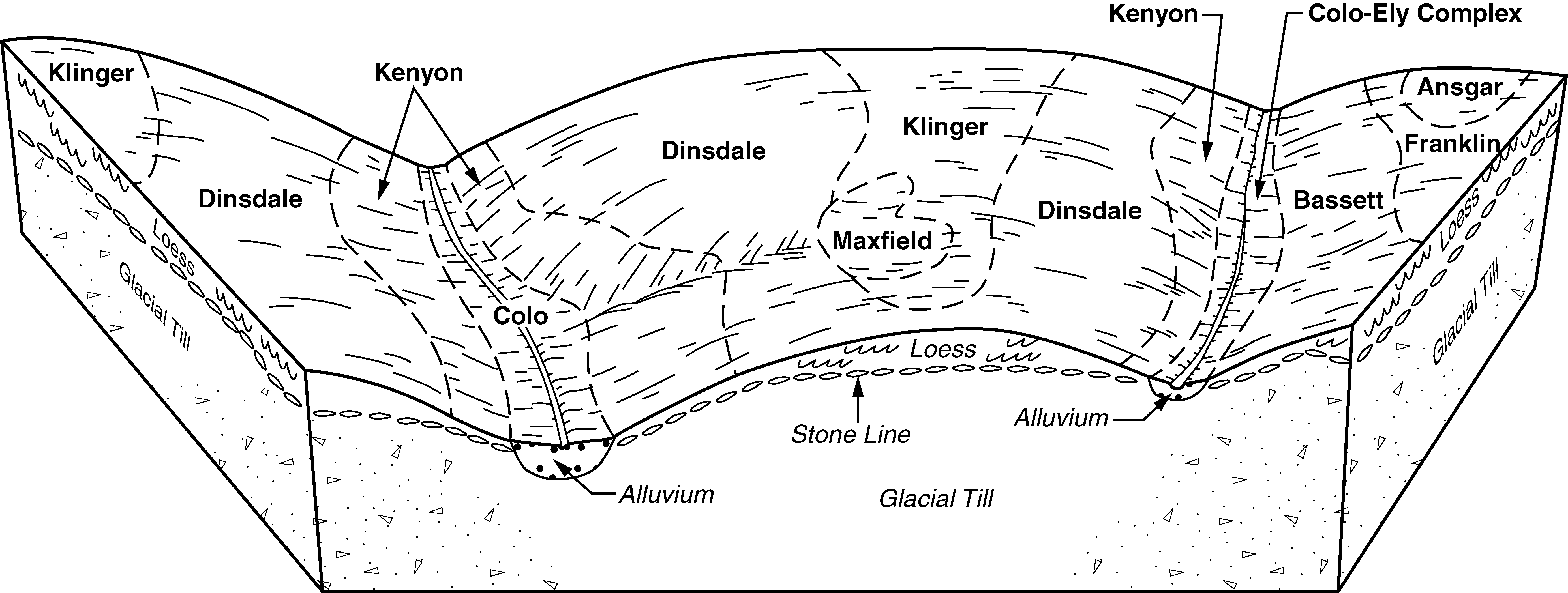
| Colo, occasionally flooded-Ely silty clay loams, dissected till plain, 2 to 5 percent slopes | 11B | 48103 | 402143 | 2wnyp | ia001 | 1976 | 1:15840 |
Zook-Colo-Ely silty clay loams, 2 to 5 percent slopes | 287B | 13086 | 402170 | 2zspb | ia001 | 1976 | 1:15840 |
Ely silty clay loam, dissected till plain, 2 to 5 percent slopes | 428B | 2008 | 402182 | 2wnyq | ia001 | 1976 | 1:15840 |
Zook-Ely-Gullied land complex, 2 to 5 percent slopes | 545B | 32606 | 1711854 | 2zdlp | ia003 | 2008 | 1:12000 |
Zook-Ely complex, 2 to 5 percent slopes | 45B | 4853 | 1544684 | 1nvcj | ia003 | 2008 | 1:12000 |
Olmitz-Ely-Zook complex, 2 to 5 percent slopes | 15B | 4441 | 1913996 | 2wxsc | ia003 | 2008 | 1:12000 |
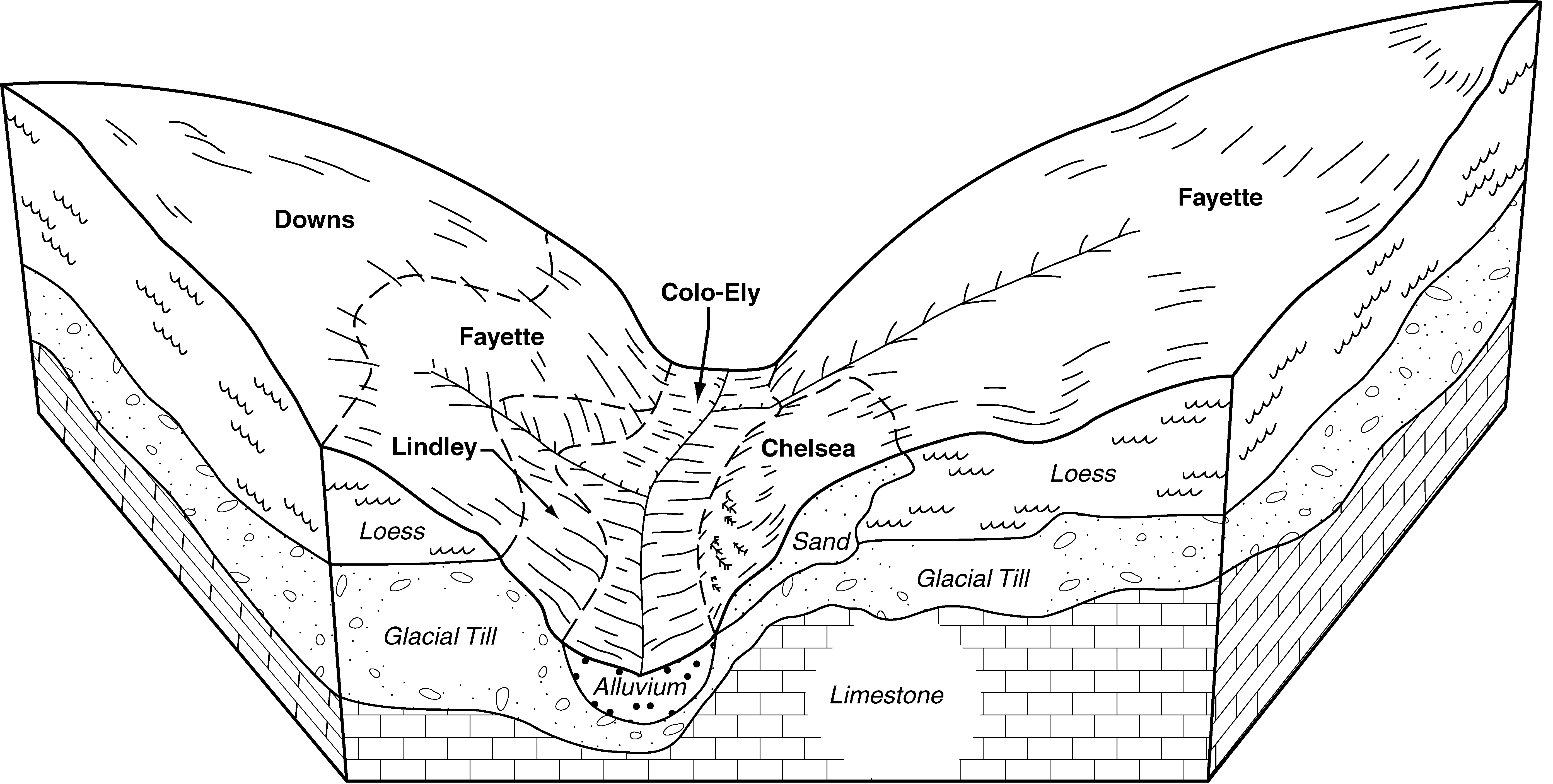
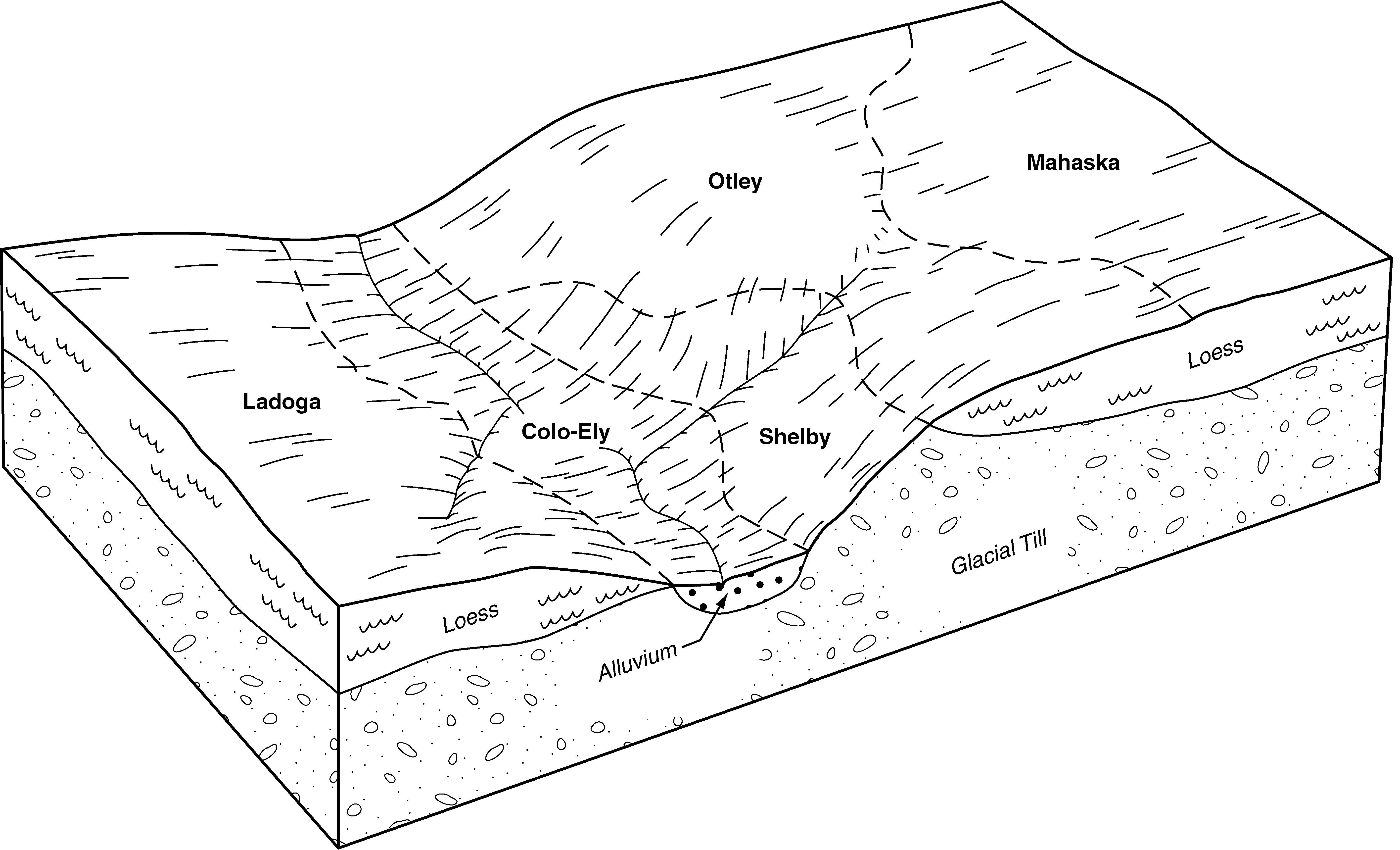
Colo-Ely complex, 0 to 5 percent slopes | 11B | 62603 | 402817 | 2t3dx | ia011 | 1977 | 1:15840 |
Ely silty clay loam, 2 to 5 percent slopes | 428B | 5901 | 402899 | 2t3fh | ia011 | 1977 | 1:15840 |
Colo-Ely complex, 0 to 5 percent slopes | 911B | 5930 | 579784 | 2t3dx | ia013 | 2001 | 1:12000 |
Colo-Ely-Urban land complex, 2 to 5 percent slopes | 4911B | 481 | 579767 | 2t3dy | ia013 | 2001 | 1:12000 |
Ely silty clay loam, shallow loess, 2 to 5 percent slopes | 428B | 562 | 403302 | 2wnyn | ia021 | 1973 | 1:15840 |
Colo-Ely complex, 0 to 5 percent slopes | 11B | 2432 | 403343 | 2t3dx | ia023 | 1978 | 1:15840 |
Ely silty clay loam, 2 to 5 percent slopes | 428B | 594 | 403412 | 2t3fh | ia023 | 1978 | 1:15840 |
Colo, overwash-Ely complex, 2 to 5 percent slopes | 113B | 21043 | 2423011 | 2zspc | ia029 | 2010 | 1:12000 |
Zook-Ely-Gullied land complex, 2 to 5 percent slopes | 545B | 4198 | 1868062 | 2zdlp | ia029 | 2010 | 1:12000 |
Ely-Colo, overwash-Mt. Sterling complex, 0 to 2 percent slopes | 2428 | 3128 | 2423017 | 2zsph | ia029 | 2010 | 1:12000 |
Olmitz-Ely-Zook complex, 2 to 5 percent slopes | 15B | 8 | 2423009 | 2wxsc | ia029 | 2010 | 1:12000 |
Colo-Ely complex, 0 to 5 percent slopes | 911B | 30705 | 1397059 | 2t3dx | ia031 | 2008 | 1:12000 |
Ely silty clay loam, 2 to 5 percent slopes | 428B | 2002 | 1397120 | 2t3fh | ia031 | 2008 | 1:12000 |
Ely silty clay loam, shallow loess, 2 to 5 percent slopes | 428B | 578 | 403933 | 2wnyn | ia035 | 1987 | 1:15840 |
Colo-Ely complex, 0 to 5 percent slopes | 11B | 13228 | 404337 | 2t3dx | ia045 | 1978 | 1:15840 |
Ely silt loam, 2 to 5 percent slopes | 428B | 2358 | 404429 | fkv3 | ia045 | 1978 | 1:15840 |
Colo, occasionally flooded-Ely silty clay loams, dissected till plain, 2 to 5 percent slopes | 11B | 2872 | 404561 | 2wnyp | ia049 | 1980 | 1:15840 |
Colo-Ely complex, 0 to 5 percent slopes | 11B | 7819 | 404976 | 2t3dx | ia055 | 1984 | 1:15840 |
Ely silty clay loam, 2 to 5 percent slopes | 428B | 929 | 405050 | 2t3fh | ia055 | 1984 | 1:15840 |
Ely silt loam, 2 to 5 percent slopes | 428B | 422 | 405432 | flwg | ia061 | 1983 | 1:15840 |
Colo-Ely complex, 0 to 5 percent slopes | 11B | 3521 | 404861 | 2t3dx | ia069 | 1977 | 1:15840 |
Ely silty clay loam, 2 to 5 percent slopes | 428B | 1555 | 404916 | 2t3fh | ia069 | 1977 | 1:15840 |
Colo-Ely complex, 0 to 5 percent slopes | 11B | 37891 | 2474646 | 2t3dx | ia075 | 1973 | 1:15840 |
Ely silty clay loam, 2 to 5 percent slopes | 428B | 1024 | 406309 | 2t3fh | ia075 | 1973 | 1:15840 |
Ely silty clay loam, dissected till plain, 2 to 5 percent slopes | 428B | 1002 | 406395 | 2wnyq | ia077 | 1968 | 1:15840 |
Colo-Ely complex, 0 to 5 percent slopes | 11B | 9126 | 406607 | 2t3dx | ia083 | 1982 | 1:15840 |
Ely silty clay loam, 2 to 5 percent slopes | 428B | 908 | 406668 | 2t3fh | ia083 | 1982 | 1:15840 |
Ely silty clay loam, shallow loess, 2 to 5 percent slopes | 428B | 1271 | 407161 | 2wnyn | ia093 | 1989 | 1:15840 |
Colo-Ely complex, 0 to 5 percent slopes | 911B | 34928 | 628333 | 2t3dx | ia095 | 2005 | 1:12000 |
Ely silty clay loam, 2 to 5 percent slopes | 428B | 5977 | 452909 | 2t3fh | ia095 | 2005 | 1:12000 |
Ely silty clay loam, 2 to 5 percent slopes | 428B | 1278 | 407507 | fp1d | ia097 | 1988 | 1:15840 |
Colo-Ely complex, 0 to 5 percent slopes | 11B | 458 | 407442 | fnz9 | ia097 | 1988 | 1:15840 |
Ely silty clay loam, 2 to 5 percent slopes | 428B | 2206 | 407661 | 2t3fh | ia099 | 1975 | 1:15840 |
Colo-Ely complex, 0 to 5 percent slopes | 11B | 26533 | 407930 | 2t3dx | ia103 | 1979 | 1:15840 |
Ely silty clay loam, 2 to 5 percent slopes | 428B | 2109 | 408014 | 2t3fh | ia103 | 1979 | 1:15840 |
Colo-Ely complex, 0 to 5 percent slopes | 11B | 16918 | 408081 | 2t3dx | ia105 | 1988 | 1:15840 |
Ely silty clay loam, 2 to 5 percent slopes | 428B | 1401 | 408160 | 2t3fh | ia105 | 1988 | 1:15840 |
Colo-Ely complex, 0 to 5 percent slopes | 911B | 2790 | 447245 | 2t3dx | ia107 | 1998 | 1:12000 |
Ely silty clay loam, 2 to 5 percent slopes | 428B | 847 | 447115 | 2t3fh | ia107 | 1998 | 1:12000 |
Colo-Ely complex, 0 to 5 percent slopes | 11B | 9873 | 408533 | 2t3dx | ia113 | 1970 | 1:15840 |
Colo-Ely-Urban land complex, 2 to 5 percent slopes | 4911B | 922 | 2606473 | 2t3dy | ia113 | 1970 | 1:15840 |
Ely silty clay loam, 2 to 5 percent slopes | 428B | 574 | 408644 | 2t3fh | ia113 | 1970 | 1:15840 |
Colo-Ely complex, 0 to 5 percent slopes | 11B | 4271 | 408708 | 2t3dx | ia115 | 1984 | 1:15840 |
Ely silty clay loam, 2 t0 5 percent slopes | 428B | 713 | 408779 | fqcf | ia115 | 1984 | 1:15840 |
Colo, frequently flooded-Ely silty clay loams, gullied, 2 to 5 percent slopes | 1134 | 13938 | 409188 | 2zdlm | ia121 | 1968 | 1:15840 |
Colo, occasionally flooded-Ely silty clay loams, dissected till plain, 2 to 5 percent slopes | 11B | 7155 | 409187 | 2wnyp | ia121 | 1968 | 1:15840 |
Ely silty clay loam, dissected till plain, 2 to 5 percent slopes | 428B | 2681 | 409190 | 2wnyq | ia121 | 1968 | 1:15840 |
Colo-Ely complex, 0 to 5 percent slopes | 11B | 18249 | 409272 | 2t3dx | ia123 | 1971 | 1:15840 |
Ely silty clay loam, 2 to 5 percent slopes | 428B | 838 | 409327 | 2t3fh | ia123 | 1971 | 1:15840 |
Colo, occasionally flooded-Ely silty clay loams, dissected till plain, 2 to 5 percent slopes | Y11B | 6439 | 3008643 | 2wnyp | ia125 | 1976 | 1:15840 |
Colo-Ely silty clay loams, 2 to 5 percent slopes | 11B | 3129 | 412715 | 2zsp8 | ia125 | 1976 | 1:15840 |
Ely silty clay loam, dissected till plain, 2 to 5 percent slopes | Y428B | 760 | 3008634 | 2wnyq | ia125 | 1976 | 1:15840 |
Ely silty clay loam, 2 to 5 percent slopes | 428B | 283 | 412777 | fvjd | ia125 | 1976 | 1:15840 |
Colo-Ely complex, 0 to 5 percent slopes | 11B | 23404 | 409404 | 2t3dx | ia127 | 1978 | 1:15840 |
Ely silty clay loam, 2 to 5 percent slopes | 428B | 1775 | 409479 | 2t3fh | ia127 | 1978 | 1:15840 |
Colo-Ely-Urban land complex, 2 to 5 percent slopes | 4011B | 333 | 409469 | 2t3dy | ia127 | 1978 | 1:15840 |
Colo-Ely complex, 0 to 5 percent slopes | 11B | 1675 | 409738 | 2t3dx | ia135 | 1982 | 1:15840 |
Ely silty clay loam, 2 to 5 percent slopes | 428B | 245 | 409788 | frdz | ia135 | 1982 | 1:15840 |
Colo-Ely complex, 0 to 5 percent slopes | 133B | 6212 | 409918 | 2t3dx | ia139 | 1986 | 1:15840 |
Colo-Ely complex, 0 to 5 percent slopes | 11B | 27829 | 410535 | 2t3dx | ia157 | 1978 | 1:15840 |
Ely silty clay loam, 2 to 5 percent slopes | 428B | 1449 | 410589 | 2t3fh | ia157 | 1978 | 1:15840 |
Zook-Ely silty clay loams, 0 to 5 percent slopes | 287B | 8617 | 410687 | fsbz | ia159 | 1987 | 1:15840 |
Ely silty clay loam, dissected till plain, 2 to 5 percent slopes | 428B | 322 | 410702 | 2wnyq | ia159 | 1987 | 1:15840 |
Ely silty clay loam, shallow loess, 2 to 5 percent slopes | 428 | 1958 | 410806 | 2wnyn | ia161 | 1975 | 1:15840 |
Colo, occasionally flooded-Ely silty clay loams, deep loess, 2 to 5 percent slopes | 11B | 877 | 410760 | 2wnyr | ia161 | 1975 | 1:15840 |
Colo-Ely complex, 0 to 5 percent slopes | 11B | 5817 | 410863 | 2t3dx | ia163 | 1989 | 1:15840 |
Ely silty clay loam, 2 to 5 percent slopes | 428B | 1615 | 410994 | 2t3fh | ia163 | 1989 | 1:15840 |
Ely silty clay loam, shallow loess, 2 to 5 percent slopes | 428B | 6428 | 411233 | 2wnyn | ia167 | 1987 | 1:15840 |
Colo-Ely complex, 0 to 5 percent slopes | 11B | 31707 | 411359 | 2t3dx | ia171 | 1989 | 1:15840 |
Ely silty clay loam, 2 to 5 percent slopes | 428B | 3038 | 411483 | 2t3fh | ia171 | 1989 | 1:15840 |
Ely silty clay loam, dissected till plain, 2 to 5 percent slopes | 428B | 264 | 411623 | 2wnyq | ia173 | 1989 | 1:15840 |
Colo, occasionally flooded-Ely silty clay loams, dissected till plain, 2 to 5 percent slopes | Y11B | 31353 | 3008642 | 2wnyp | ia175 | 1975 | 1:15840 |
Colo-Ely silty clay loams, 2 to 5 percent slopes | 11B | 3004 | 411668 | 2zsp8 | ia175 | 1975 | 1:15840 |
Colo-Ely complex, 0 to 5 percent slopes | 11B | 8354 | 411754 | 2t3dx | ia179 | 1978 | 1:15840 |
Gullied land-Ely-Colo, occasionally flooded, complex, 2 to 5 percent slopes | 980B | 10058 | 411983 | 2zdln | ia181 | 1975 | 1:15840 |
Colo, occasionally flooded-Ely silty clay loams, dissected till plain, 2 to 5 percent slopes | Y11B | 5634 | 3008641 | 2wnyp | ia181 | 1975 | 1:15840 |
Ely silty clay loam, dissected till plain, 2 to 5 percent slopes | Y428B | 3148 | 3008637 | 2wnyq | ia181 | 1975 | 1:15840 |
Colo-Ely silty clay loams, 2 to 5 percent slopes | 11B | 1618 | 411875 | 2zsp8 | ia181 | 1975 | 1:15840 |
Ely silty clay loam, 2 to 5 percent slopes | 428B | 255 | 411937 | ftn9 | ia181 | 1975 | 1:15840 |
Ely silty clay loam, 2 to 5 percent slopes | 428B | 1285 | 412054 | 2t3fh | ia183 | 1983 | 1:15840 |
Colo-Ely complex, 0 to 5 percent slopes | 11B | 1104 | 412000 | 2t3dx | ia183 | 1983 | 1:15840 |
Olmitz-Ely-Zook complex, 2 to 5 percent slopes | 30242 | 815 | 2671847 | 2wxsc | mo005 | 1988 | 1:24000 |
Olmitz-Ely-Zook complex, 2 to 5 percent slopes | 30242 | 2539 | 2671848 | 2wxsc | mo147 | 1983 | 1:24000 |
Olmitz-Ely-Zook complex, 2 to 5 percent slopes | 30242 | 29 | 2607695 | 2wxsc | mo227 | 1965 | 1:24000 |
