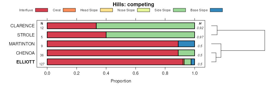
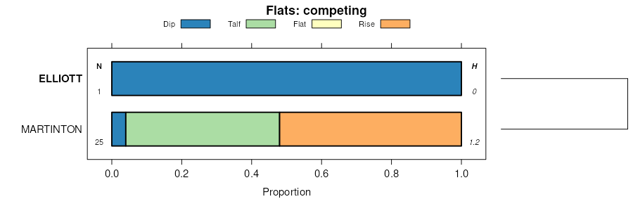
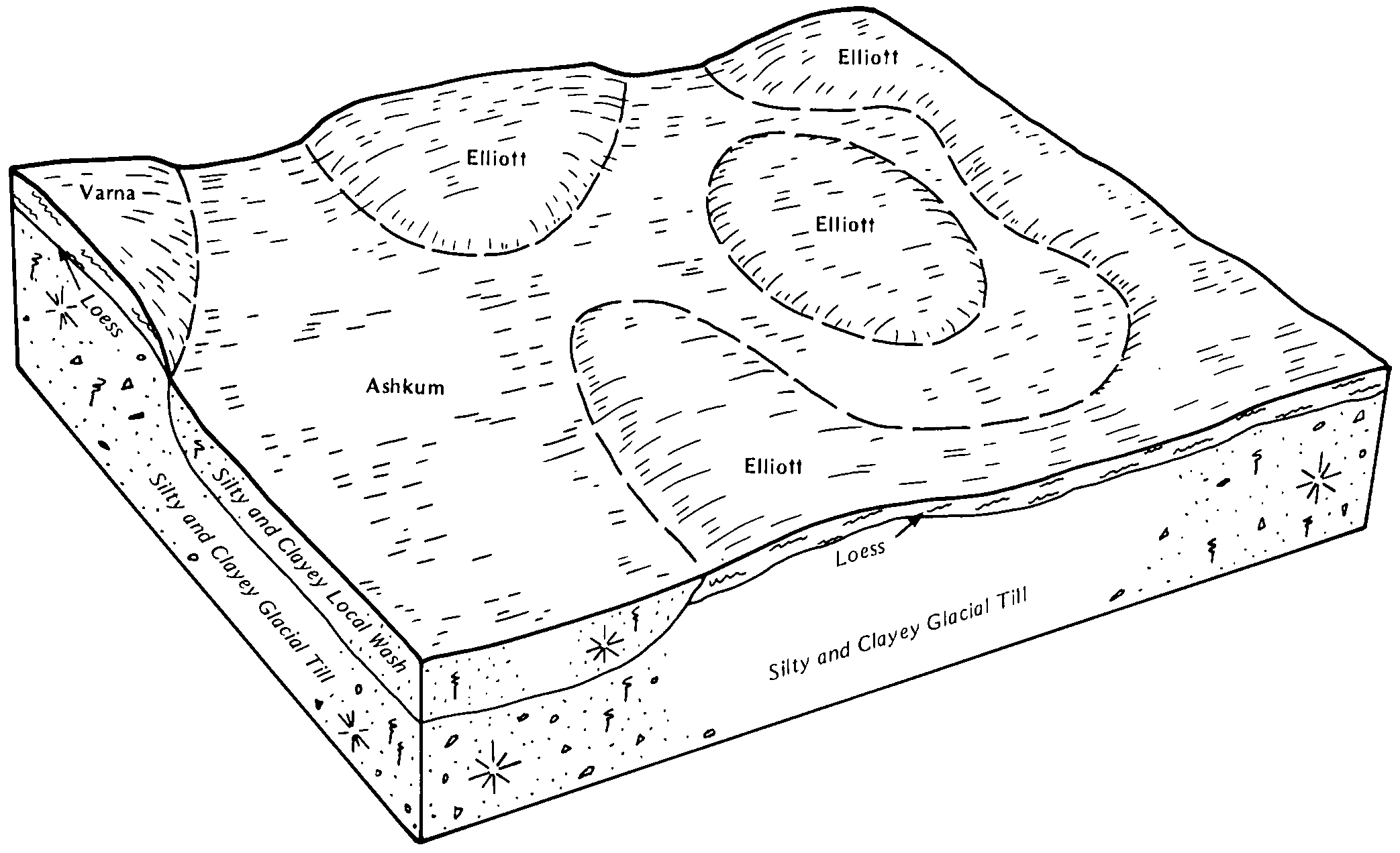
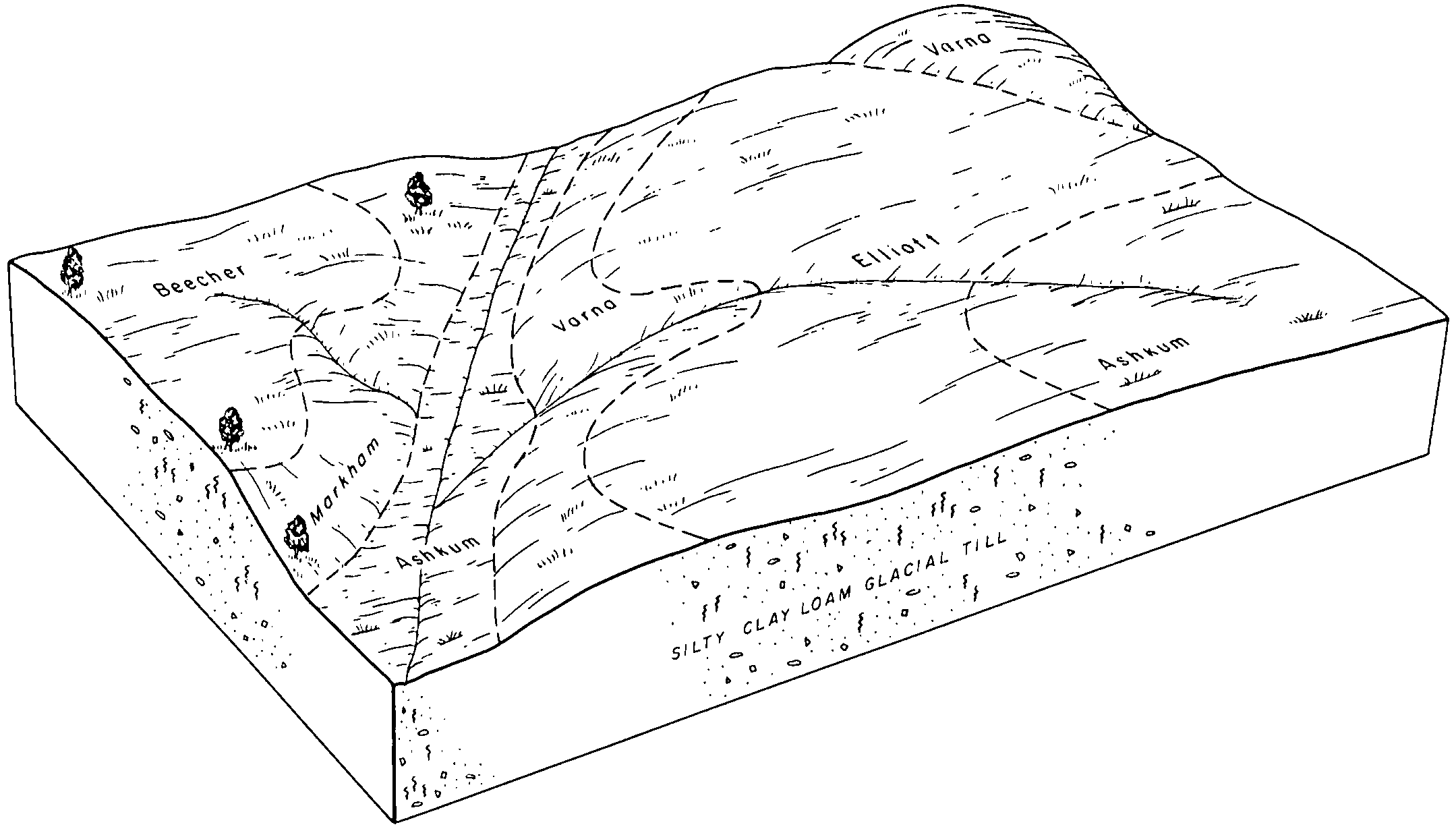
| Elliott silt loam, 0 to 2 percent slopes | 146A | 146 | 199784 | 6pwn | il007 | 2006 | 1:12000 |
Elliott silty clay loam, 2 to 4 percent slopes, eroded | 146B2 | 28476 | 243014 | 2sss2 | il019 | 1999 | 1:12000 |
Elliott silty clay loam, 4 to 6 percent slopes, eroded | 146C2 | 1485 | 242976 | 2smzt | il019 | 1999 | 1:12000 |
Elliott silt loam, 0 to 2 percent slopes | 146A | 761 | 242960 | 2sss0 | il019 | 1999 | 1:12000 |
Anthroportic Udorthents-Urban land-Elliott complex, 0 to 2 percent slopes | 2822A | 21577 | 2518161 | 2yrr6 | il031 | 2008 | 1:12000 |
Anthroportic Udorthents-Urban land-Elliott complex, 2 to 4 percent slopes | 2822B | 9056 | 2518162 | 2yrr7 | il031 | 2008 | 1:12000 |
Elliott silt loam, 0 to 2 percent slopes | 146A | 6482 | 2108712 | 2sss0 | il031 | 2008 | 1:12000 |
Elliott silt loam, 2 to 4 percent slopes | 146B | 1633 | 2108711 | 2sss1 | il031 | 2008 | 1:12000 |
Anthroportic Udorthents-Elliott complex, 0 to 2 percent slopes | 822A | 1003 | 2518157 | 2yrr8 | il031 | 2008 | 1:12000 |
Anthroportic Udorthents-Elliott complex, 2 to 4 percent slopes | 822B | 171 | 2518158 | 2yrr9 | il031 | 2008 | 1:12000 |
Elliott silt loam, 0 to 2 percent slopes | 146A | 9240 | 183352 | 2sss0 | il043 | 1998 | 1:12000 |
Elliott silt loam, 2 to 4 percent slopes | 146B | 597 | 183353 | 2sss1 | il043 | 1998 | 1:12000 |
Elliott silt loam, 0 to 2 percent slopes | 146A | 28437 | 198296 | 2sss0 | il053 | 2001 | 1:12000 |
Elliott silty clay loam, 2 to 4 percent slopes, eroded | 146B2 | 14735 | 198297 | 2sss2 | il053 | 2001 | 1:12000 |
Elliott silt loam, 0 to 2 percent slopes | 146A | 17891 | 868705 | 2sss0 | il063 | 2005 | 1:12000 |
Elliott silt loam, 2 to 4 percent slopes | 146B | 1930 | 1143972 | 2sss1 | il063 | 2005 | 1:12000 |
Elliott silt loam, 0 to 2 percent slopes | 146A | 6385 | 175544 | 2sss0 | il075 | 1980 | 1:15840 |
Elliott silt loam, 2 to 4 percent slopes | 146B | 2462 | 175545 | 2sss1 | il075 | 1980 | 1:15840 |
Elliott silty clay loam, 2 to 4 percent slopes, eroded | 146B2 | 1675 | 175546 | 2sss2 | il075 | 1980 | 1:15840 |
Elliott silt loam, 0 to 2 percent slopes | 146A | 2386 | 271302 | 2sss0 | il089 | 2000 | 1:12000 |
Elliott silt loam, 2 to 4 percent slopes | 146B | 1244 | 271301 | 2sss1 | il089 | 2000 | 1:12000 |
Elliott silt loam, 0 to 2 percent slopes | 146A | 15849 | 263165 | 2sss0 | il091 | 2003 | 1:12000 |
Elliott silt loam, 2 to 4 percent slopes | 146B | 9666 | 263166 | 2sss1 | il091 | 2003 | 1:12000 |
Elliott silty clay loam, 2 to 4 percent slopes, eroded | 146B2 | 725 | 977652 | 2sss2 | il091 | 2003 | 1:12000 |
Elliott silt loam, 2 to 4 percent slopes | 146B | 12 | 1715623 | 2sss1 | il093 | 2007 | 1:12000 |
Elliott silt loam, 2 to 4 percent slopes | 146B | 6398 | 634244 | 2sss1 | il097 | 2003 | 1:12000 |
Elliott silt loam, 0 to 2 percent slopes | 146A | 2352 | 630860 | 2sss0 | il097 | 2003 | 1:12000 |
Mundelein and Elliott silt loams, 2 to 4 percent slopes | 989B | 1774 | 809251 | w52w | il097 | 2003 | 1:12000 |
Mundelein and Elliott silt loams, 0 to 2 percent slopes | 989A | 1607 | 809248 | w52s | il097 | 2003 | 1:12000 |
Elliott silt loam, 2 to 4 percent slopes | 146B | 7511 | 263372 | 2sss1 | il099 | 2006 | 1:12000 |
Elliott silty clay loam, 2 to 4 percent slopes, eroded | 146B2 | 894 | 1029932 | 2sss2 | il099 | 2006 | 1:12000 |
Elliott silt loam, 0 to 2 percent slopes | 146A | 584 | 263371 | 2sss0 | il099 | 2006 | 1:12000 |
Elliott silt loam, 0 to 2 percent slopes | 146A | 16861 | 176921 | 2sss0 | il105 | 1991 | 1:15840 |
Elliott silty clay loam, 2 to 4 percent slopes, eroded | 146B2 | 14837 | 176923 | 2sss2 | il105 | 1991 | 1:15840 |
Elliott silty clay loam, 4 to 6 percent slopes, eroded | 146C2 | 974 | 176924 | 2smzt | il105 | 1991 | 1:15840 |
Elliott silt loam, 2 to 4 percent slopes | 146B | 468 | 176922 | 2sss1 | il105 | 1991 | 1:15840 |
Elliott silt loam, 2 to 4 percent slopes | 146B | 3071 | 182404 | 2sss1 | il111 | 1997 | 1:12000 |
Elliott silt loam, 0 to 2 percent slopes | 146A | 1817 | 182403 | 2sss0 | il111 | 1997 | 1:12000 |
Elliott silt loam, 0 to 2 percent slopes | 146A | 70 | 185327 | 2sss0 | il113 | 2000 | 1:12000 |
Elliott silt loam, 0 to 2 percent slopes | 146A | 48267 | 1601024 | 2sss0 | il183 | 2006 | 1:12000 |
Elliott silty clay loam, 2 to 4 percent slopes, eroded | 146B2 | 23713 | 1601124 | 2sss2 | il183 | 2006 | 1:12000 |
Elliott silty clay loam, 4 to 6 percent slopes, eroded | 146C2 | 1098 | 1674310 | 2smzt | il183 | 2006 | 1:12000 |
Elliott silt loam, 2 to 4 percent slopes | 146B | 72025 | 262291 | 2sss1 | il197 | 2002 | 1:12000 |
Elliott silt loam, 0 to 2 percent slopes | 146A | 11650 | 262290 | 2sss0 | il197 | 2002 | 1:12000 |
Elliott silty clay loam, 2 to 4 percent slopes, eroded | 146B2 | 5893 | 262292 | 2sss2 | il197 | 2002 | 1:12000 |
Elliott silt loam, 0 to 2 percent slopes | 146A | 602 | 173961 | 5v0n | il201 | 1997 | 1:12000 |
Elliott silty clay loam, 2 to 4 percent slopes, eroded | ElB2 | 2016 | 164562 | 2sss2 | in007 | 1985 | 1:15840 |
Elliott silt loam, 0 to 2 percent slopes | ElA | 1403 | 164561 | 2sss0 | in007 | 1985 | 1:15840 |
Elliott silt loam, 0 to 2 percent slopes | El | 23122 | 272458 | 2sss0 | in089 | 1967 | 1:15840 |
Elliott silt loam, 0 to 2 percent slopes | ElA | 9296 | 160645 | 2sss0 | in127 | 1978 | 1:15840 |
Williamsport-Elliott silt loams, 0 to 2 percent slopes | WrA | 13996 | 163185 | 5gt1 | in171 | 1987 | 1:15840 |
Elliott silt loam, 0 to 2 percent slopes | ElA | 4481 | 161847 | 2sss0 | in181 | 1979 | 1:20000 |
Elliott silt loam, 0 to 3 percent slopes | EtA | 2398 | 168560 | 5ndf | oh033 | 1975 | 1:15840 |
Elliott silt loam, bedrock substratum, 0 to 2 percent slopes | EcA | 1195 | 172133 | 5s3p | oh043 | 1998 | 1:12000 |
Elliott silt loam, 0 to 2 percent slopes | EmA | 869 | 644385 | pmjm | oh063 | 1997 | 1:12000 |
Elliott silty clay loam, 0 to 3 percent slopes | EtA | 1702 | 171188 | 5r46 | oh101 | 1984 | 1:15840 |
Elliott silt loam, 0 to 3 percent slopes | EsA | 9 | 1400464 | 1j098 | oh101 | 1984 | 1:15840 |
Elliott silt loam, 1 to 4 percent slopes | EoB | 2856 | 169931 | 5ptn | oh107 | 1975 | 1:15840 |
Elliott silt loam, 0 to 4 percent slopes | EoB | 436 | 168081 | 5mwz | oh161 | 1967 | 1:15840 |
Elliott silt loam, 0 to 3 percent slopes | EtA | 2380 | 169608 | 5ph7 | oh175 | 1980 | 1:15840 |
Elliott silt loam, 2 to 6 percent slopes | 7146B | 4070 | 425434 | g8pp | wi039 | 1967 | 1:15840 |
Elliott silt loam, 0 to 2 percent slopes | 7146A | 1959 | 425433 | g8pn | wi039 | 1967 | 1:15840 |
Elliott silty clay loam, 2 to 6 percent slopes | 7146B | 12078 | 3268635 | g779 | wi059 | 2023 | 1:15840 |
Elliott silt loam, 0 to 2 percent slopes | 7146A | 1542 | 3268634 | 2sss0 | wi059 | 2023 | 1:15840 |
Elliott silt loam, 1 to 3 percent slopes | 7146B | 921 | 3403296 | g93c | wi079 | 2023 | 1:15840 |
Elliott silty clay loam, 2 to 6 percent slopes | 7146B | 14663 | 3268767 | g779 | wi101 | 2023 | 1:15840 |
Elliott silt loam, 0 to 2 percent slopes | 7146A | 2474 | 3268766 | 2sss0 | wi101 | 2023 | 1:15840 |
Elliott silt loam, 1 to 3 percent slopes | 7146B | 828 | 3403386 | g93c | wi133 | 2023 | 1:15840 |