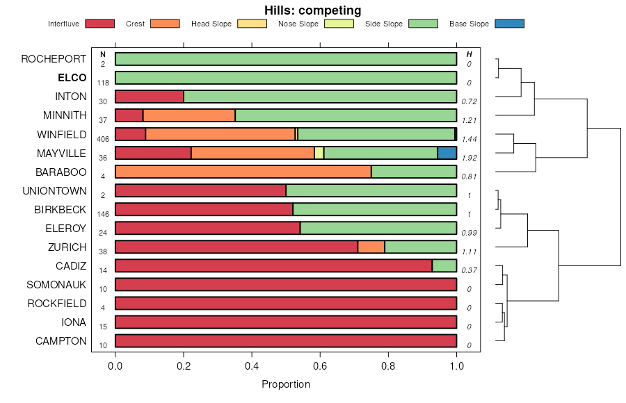
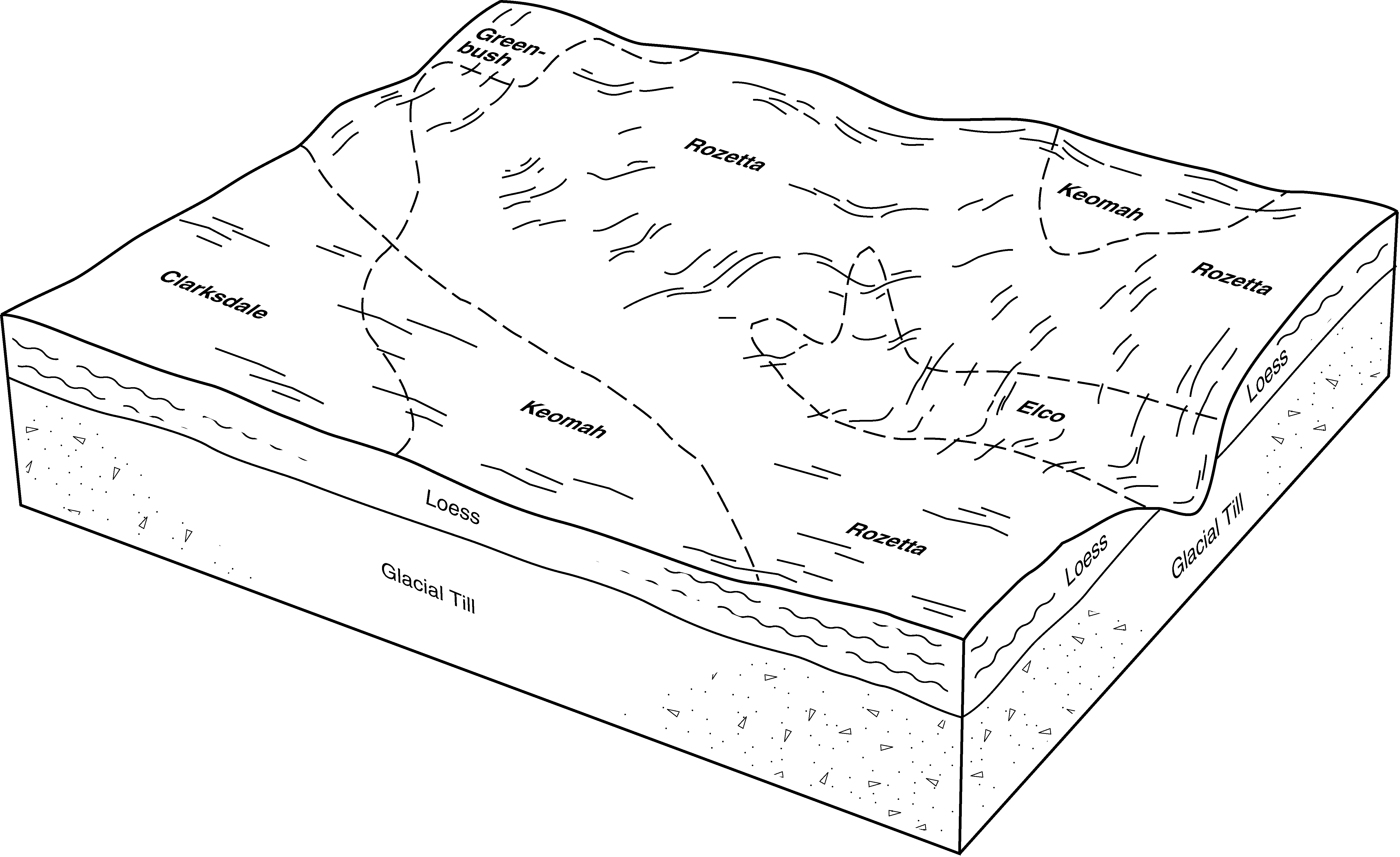
| Elco silt loam, 2 to 5 percent slopes | 119B | 160 | 1395229 | 30t7v | il007 | 2006 | 1:12000 |
Elco silt loam, 10 to 18 percent slopes, eroded | 119D2 | 2178 | 2604154 | 30t7y | il009 | 1984 | 1:12000 |
Elco silty clay loam, 10 to 18 percent slopes, severely eroded | 119D3 | 1133 | 172942 | 310t4 | il009 | 1984 | 1:12000 |
Elco silt loam, 10 to 18 percent slopes | 119D | 720 | 172941 | 30t7x | il009 | 1984 | 1:12000 |
Elco silt loam, 5 to 10 percent slopes, eroded | 119C2 | 7022 | 261673 | 310t2 | il021 | 1999 | 1:12000 |
Elco silt loam, 10 to 18 percent slopes, eroded | 119D2 | 214 | 261740 | 30t7y | il021 | 1999 | 1:12000 |
Elco silty clay loam, 10 to 15 percent slopes, severely eroded | 119D3 | 850 | 174634 | 5vqc | il027 | 1992 | 1:15840 |
Elco silt loam, 5 to 10 percent slopes, eroded | 119C2 | 3853 | 195699 | 6kmw | il033 | 2004 | 1:12000 |
Elco silt loam, 10 to 18 percent slopes | 119D | 1211 | 195700 | 6kmx | il033 | 2004 | 1:12000 |
Elco silt loam, 10 to 18 percent slopes, eroded | 119D2 | 6314 | 615637 | 30t7y | il057 | 1997 | 1:12000 |
Elco silt loam, 18 to 25 percent slopes, eroded | 119E2 | 4047 | 615638 | 30t80 | il057 | 1997 | 1:12000 |
Elco silt loam, 10 to 18 percent slopes, eroded | 119D2 | 60 | 211735 | 30t7y | il061 | 1968 | 1:15840 |
Elco silt loam, 5 to 10 percent slopes, eroded | 119C2 | 59 | 211733 | 310t2 | il061 | 1968 | 1:15840 |
Elco silty clay loam, 10 to 18 percent slopes, severely eroded | 119D3 | 7 | 2542229 | 310t4 | il061 | 1968 | 1:15840 |
Elco silty clay loam, 5 to 10 percent slopes, severely eroded | 119C3 | 6 | 2542227 | 30t7w | il061 | 1968 | 1:15840 |
Elco-Ursa complex, 10 to 18 percent slopes, eroded | 915D2 | 9592 | 175239 | 5wbw | il067 | 1993 | 1:15840 |
Elco silt loam, 5 to 10 percent slopes, eroded | 119C2 | 3671 | 175155 | 310t2 | il067 | 1993 | 1:15840 |
Elco-Atlas silty clay loams, 10 to 18 percent slopes, severely eroded | 957D3 | 12 | 2604128 | 2r78d | il067 | 1993 | 1:15840 |
Elco-Atlas silty clay loams, 10 to 18 percent slopes, severely eroded | 957D3 | 2461 | 1412396 | 1jdq5 | il071 | 2005 | 1:12000 |
Elco-Atlas silt loams, 10 to 18 percent slopes, eroded | 957D2 | 2130 | 1480526 | 1lplx | il071 | 2005 | 1:12000 |
Rozetta-Elco silt loams, 10 to 18 percent slopes, eroded | 724D2 | 452 | 1412404 | 1jdqf | il071 | 2005 | 1:12000 |
Elco silt loam, 18 to 25 percent slopes, eroded | 119E2 | 56 | 1480504 | 30t80 | il071 | 2005 | 1:12000 |
Elco silt loam, 10 to 18 percent slopes, eroded | 119D2 | 2669 | 244653 | 30t7y | il073 | 2001 | 1:12000 |
Elco-Atlas silty clay loams, 10 to 18 percent slopes, severely eroded | 957D3 | 2621 | 244782 | 86q6 | il073 | 2001 | 1:12000 |
Elco silty clay loam, 10 to 18 percent slopes, severely eroded | 119D3 | 1406 | 244654 | 310t4 | il073 | 2001 | 1:12000 |
Elco silty clay loam, 10 to 18 percent slopes, severely eroded | 119D3 | 9977 | 728447 | 310t4 | il083 | 2002 | 1:12000 |
Elco silt loam, 5 to 10 percent slopes, eroded | 119C2 | 3274 | 729239 | 310t2 | il083 | 2002 | 1:12000 |
Elco silt loam, 10 to 18 percent slopes, eroded | 119D2 | 3226 | 728446 | 30t7y | il083 | 2002 | 1:12000 |
Elco silty clay loam, 5 to 10 percent slopes, severely eroded | 119C3 | 1873 | 728454 | 30t7w | il083 | 2002 | 1:12000 |
Elco silt loam, 5 to 10 percent slopes, eroded | 119C2 | 2176 | 1949538 | 310t2 | il085 | 1990 | 1:12000 |
Elco silt loam, 10 to 18 percent slopes, eroded | 119D2 | 9271 | 680934 | 30t7y | il095 | 2002 | 1:12000 |
Elco silt loam, 18 to 25 percent slopes, eroded | 119E2 | 4655 | 680935 | 30t80 | il095 | 2002 | 1:12000 |
Elco silt loam, 10 to 18 percent slopes, eroded | 119D2 | 4430 | 634119 | 30t7y | il109 | 2002 | 1:12000 |
Elco silt loam, 5 to 10 percent slopes, eroded | 119C2 | 3595 | 634248 | 310t2 | il109 | 2002 | 1:12000 |
Elco silt loam, 18 to 25 percent slopes, eroded | 119E2 | 977 | 634257 | 30t80 | il109 | 2002 | 1:12000 |
Elco silt loam, 5 to 10 percent slopes, eroded | 119C2 | 168 | 1913930 | 310t2 | il115 | 2007 | 1:12000 |
Elco silt loam, 5 to 10 percent slopes, eroded | 119C2 | 6631 | 199177 | 310t2 | il117 | 1999 | 1:12000 |
Elco silt loam, 10 to 18 percent slopes, eroded | 119D2 | 1567 | 199246 | 30t7y | il117 | 1999 | 1:12000 |
Elco silt loam, 2 to 5 percent slopes, eroded | 119B2 | 1325 | 199176 | 310t1 | il117 | 1999 | 1:12000 |
Elco silty clay loam, 10 to 18 percent slopes, severely eroded | 119D3 | 8 | 641229 | 310t4 | il117 | 1999 | 1:12000 |
Elco silty clay loam, 5 to 10 percent slopes, severely eroded | 119C3 | 2 | 641135 | 30t7w | il117 | 1999 | 1:12000 |
Elco silty clay loam, 5 to 10 percent slopes, severely eroded | 119C3 | 5352 | 198955 | 30t7w | il119 | 2001 | 1:12000 |
Elco silty clay loam, 10 to 18 percent slopes, severely eroded | 119D3 | 4130 | 198954 | 310t4 | il119 | 2001 | 1:12000 |
Elco silt loam, 10 to 18 percent slopes, eroded | 119D2 | 2324 | 198956 | 6p0y | il119 | 2001 | 1:12000 |
Elco silty clay loam, 10 to 18 percent slopes, severely eroded | 119D3 | 1 | 1407469 | 310t4 | il129 | 2005 | 1:12000 |
Elco silt loam, 10 to 18 percent slopes, eroded | 119D2 | 1 | 1407468 | 30t7y | il129 | 2005 | 1:12000 |
Elco-Atlas silty clay loams, 10 to 18 percent slopes, severely eroded | 957D3 | 6602 | 245017 | 86ys | il131 | 2000 | 1:12000 |
Elco silt loam, 10 to 18 percent slopes | 119D | 2032 | 244958 | 30t7x | il131 | 2000 | 1:12000 |
Elco silt loam, 10 to 18 percent slopes, eroded | 119D2 | 32 | 244959 | 30t7y | il131 | 2000 | 1:12000 |
Elco silt loam, 10 to 18 percent slopes, eroded | 119D2 | 5819 | 1672111 | 30t7y | il137 | 1984 | 1:15840 |
Elco silt loam, 18 to 25 percent slopes, eroded | 119E2 | 2107 | 1672113 | 30t80 | il137 | 1984 | 1:15840 |
Elco silty clay loam, 10 to 18 percent slopes, severely eroded | 119D3 | 868 | 1672112 | 310t4 | il137 | 1984 | 1:15840 |
Elco-Ursa silt loams, 18 to 25 percent slopes, eroded | 915E2 | 745 | 1672185 | 1t41g | il137 | 1984 | 1:15840 |
Elco-Ursa silt loams, 10 to 18 percent slopes, eroded | 915D2 | 408 | 1672184 | 1t41f | il137 | 1984 | 1:15840 |
Elco silt loam, 5 to 10 percent slopes, eroded | 119C2 | 717 | 208544 | 310t2 | il141 | 2005 | 1:12000 |
Elco silt loam, 10 to 18 percent slopes, eroded | 119D2 | 4287 | 208951 | 30t7y | il143 | 1986 | 1:15840 |
Elco silt loam, 18 to 25 percent slopes | 119E | 1732 | 208952 | 30t7z | il143 | 1986 | 1:15840 |
Elco silt loam, 10 to 18 percent slopes, eroded | 119D2 | 2480 | 201127 | 30t7y | il149 | 2001 | 1:12000 |
Elco silt loam, 18 to 25 percent slopes, eroded | 119E2 | 1446 | 201129 | 30t80 | il149 | 2001 | 1:12000 |
Elco silty clay loam, 10 to 18 percent slopes, severely eroded | 119D3 | 513 | 201128 | 310t4 | il149 | 2001 | 1:12000 |
Elco silt loam, 10 to 18 percent slopes, eroded | 119D2 | 5675 | 199296 | 30t7y | il167 | 1999 | 1:12000 |
Elco silty clay loam, 10 to 18 percent slopes, severely eroded | 119D3 | 4822 | 199297 | 310t4 | il167 | 1999 | 1:12000 |
Elco silt loam, 10 to 18 percent slopes | 119D | 2372 | 199363 | 30t7x | il167 | 1999 | 1:12000 |
Elco silt loam, 5 to 10 percent slopes, eroded | 119C2 | 1066 | 199362 | 310t2 | il167 | 1999 | 1:12000 |
Elco silt loam, 10 to 18 percent slopes, eroded | 119D2 | 2185 | 2542065 | 30t7y | il171 | 1984 | 1:12000 |
Elco silt loam, 18 to 25 percent slopes, eroded | 119E2 | 2061 | 2542067 | 30t80 | il171 | 1984 | 1:12000 |
Elco silty clay loam, 10 to 18 percent slopes, severely eroded | 119D3 | 835 | 2542066 | 310t4 | il171 | 1984 | 1:12000 |
Elco-Ursa silt loams, 10 to 18 percent slopes, eroded | 915D2 | 153 | 2542079 | 2qrch | il171 | 1984 | 1:12000 |
Elco-Ursa silt loams, 18 to 25 percent slopes, eroded | 915E2 | 114 | 2542080 | 2qrcj | il171 | 1984 | 1:12000 |
Elco silt loam, 10 to 18 percent slopes, eroded | 119D2 | 942 | 179051 | 30t7y | il175 | 1992 | 1:15840 |
Elco silty clay loam, 10 to 18 percent slopes, severely eroded | 119D3 | 596 | 179052 | 310t4 | il175 | 1992 | 1:15840 |
Elco silt loam, 18 to 25 percent slopes, eroded | 119E2 | 407 | 179053 | 30t80 | il175 | 1992 | 1:15840 |
Elco silt loam, 5 to 10 percent slopes, eroded | 119C2 | 274 | 179050 | 310t2 | il175 | 1992 | 1:15840 |
Elco silt loam, 5 to 10 percent slopes, eroded | 119C2 | 1286 | 1592074 | 310t2 | il177 | 2006 | 1:12000 |
Elco silt loam, 10 to 18 percent slopes, eroded | 119D2 | 4138 | 244875 | 30t7y | il187 | 2002 | 1:12000 |
Elco-Atlas silty clay loams, 10 to 18 percent slopes, severely eroded | 957D3 | 3529 | 244928 | 86vx | il187 | 2002 | 1:12000 |
Elco silt loam, 18 to 25 percent slopes, eroded | 119E2 | 2752 | 244876 | 30t80 | il187 | 2002 | 1:12000 |
Elco-Atlas silt loams, 10 to 18 percent slopes, eroded | 957D2 | 1610 | 244927 | 86vw | il187 | 2002 | 1:12000 |
Elco silt loam, 2 to 5 percent slopes | 119B | 239 | 173952 | 30t7v | il201 | 1997 | 1:12000 |