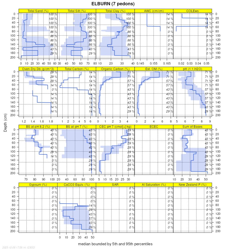
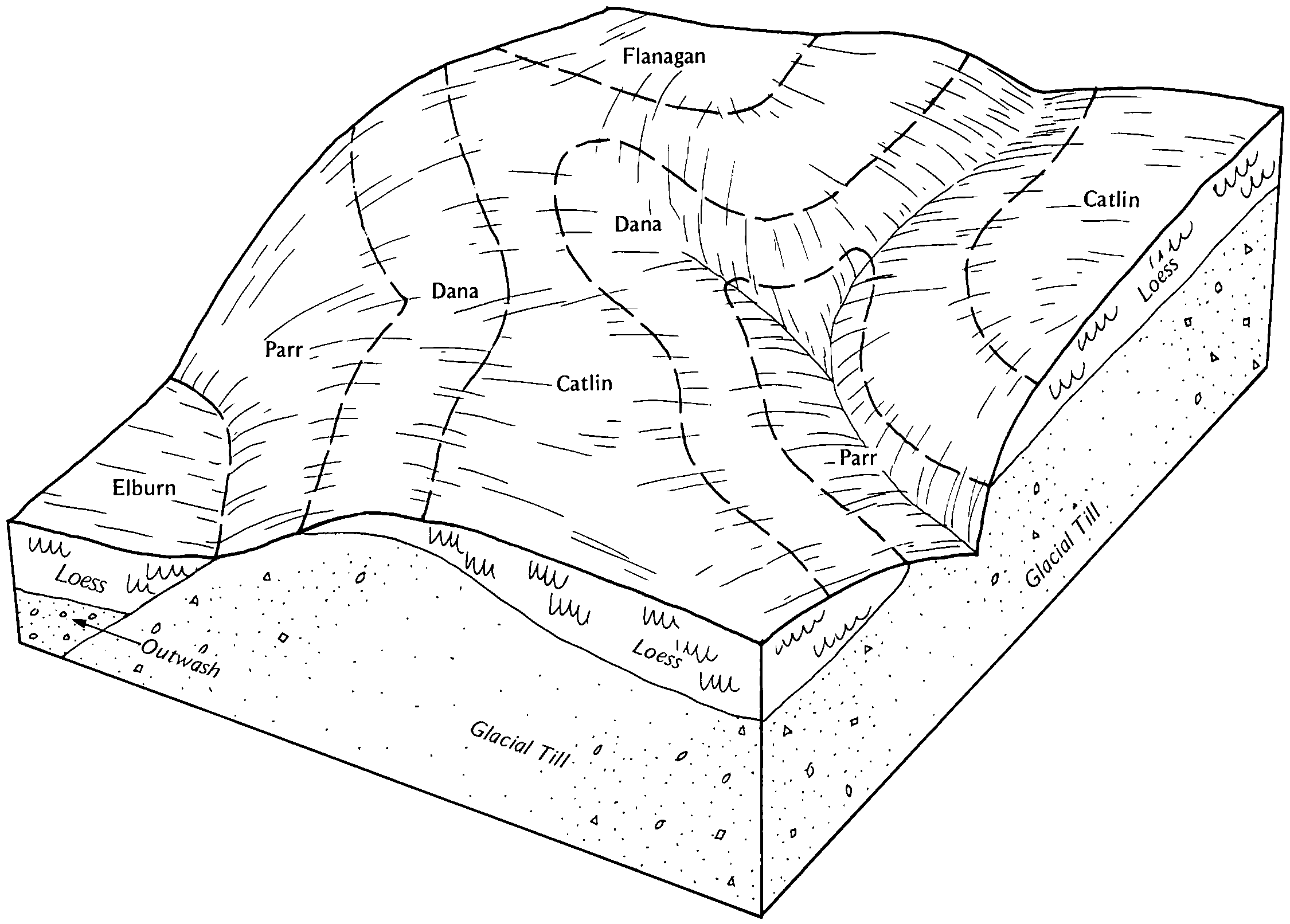
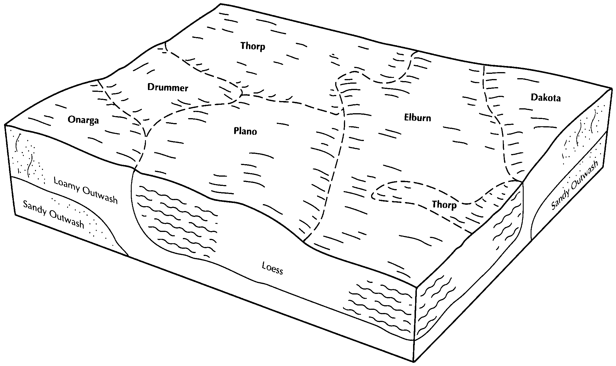
| Elburn silt loam, cool, 0 to 2 percent slopes | 198A | 3861 | 1395354 | 2wsqv | il007 | 2006 | 1:12000 |
Elburn silt loam, 0 to 2 percent slopes | 198A | 9657 | 1862710 | 2smzr | il011 | 2007 | 1:12000 |
Elburn silt loam, 0 to 2 percent slopes | 198A | 17649 | 242997 | 2smzr | il019 | 1999 | 1:12000 |
Elburn silt loam, 0 to 2 percent slopes | 198A | 2414 | 261770 | 2smzr | il021 | 1999 | 1:12000 |
Elburn silt loam, 0 to 2 percent slopes | 198A | 9384 | 183909 | 2smzr | il037 | 1998 | 1:12000 |
Elburn silt loam, 0 to 2 percent slopes | 198A | 2109 | 1531247 | 2smzr | il039 | 2005 | 1:12000 |
Elburn silt loam, sandy substratum, 0 to 2 percent slopes | 726A | 523 | 1595552 | 1qk9f | il039 | 2005 | 1:12000 |
Elburn silt loam, 0 to 2 percent slopes, rarely flooded | 7198A | 471 | 1597747 | 1qml7 | il039 | 2005 | 1:12000 |
Elburn silt loam, 0 to 2 percent slopes | 198A | 11724 | 200193 | 2smzr | il041 | 2004 | 1:12000 |
Elburn silt loam, 0 to 2 percent slopes | 198A | 7885 | 843554 | 2smzr | il045 | 1997 | 1:12000 |
Elburn silt loam, 0 to 2 percent slopes | 198A | 294 | 615643 | 2smzr | il057 | 1997 | 1:12000 |
Elburn silt loam, 0 to 2 percent slopes | 198A | 14608 | 244662 | 2smzr | il073 | 2001 | 1:12000 |
Elburn silt loam, 0 to 2 percent slopes | 198A | 5667 | 198813 | 2smzr | il089 | 2000 | 1:12000 |
Elburn silt loam, 0 to 2 percent slopes | 198A | 6148 | 1712535 | 2smzr | il093 | 2007 | 1:12000 |
Elburn silt loam, 0 to 2 percent slopes | 198A | 14731 | 263404 | 2smzr | il099 | 2006 | 1:12000 |
Elburn silt loam, 0 to 2 percent slopes | 198A | 12641 | 926836 | 2smzr | il103 | 2004 | 1:12000 |
Elburn silt loam, 0 to 2 percent slopes | 198A | 4970 | 1595750 | 2smzr | il107 | 2006 | 1:12000 |
Elburn silt loam, 0 to 2 percent slopes, rarely flooded | 7198A | 2238 | 1600625 | 1qql2 | il107 | 2006 | 1:12000 |
Elburn silt loam, sandy substratum, 0 to 2 percent slopes | 726A | 1521 | 1600629 | 1qql6 | il107 | 2006 | 1:12000 |
Elburn silt loam, cool, 0 to 2 percent slopes | 198A | 5438 | 182470 | 2wsqv | il111 | 1997 | 1:12000 |
Elburn silt loam, 0 to 2 percent slopes | 198A | 5536 | 199086 | 2smzr | il113 | 2000 | 1:12000 |
Elburn silt loam, 0 to 2 percent slopes | 198A | 14174 | 1913941 | 2smzr | il115 | 2007 | 1:12000 |
Elburn silt loam, 0 to 2 percent slopes, rarely flooded | 7198A | 124 | 1913989 | 227nl | il115 | 2007 | 1:12000 |
Elburn silt loam, 0 to 2 percent slopes | 198A | 527 | 182101 | 2smzr | il123 | 1997 | 1:15840 |
Elburn silt loam, 0 to 2 percent slopes | 198A | 4813 | 177767 | 2smzr | il125 | 1989 | 1:15840 |
Elburn silt loam, 0 to 2 percent slopes, rarely flooded | 7198A | 110 | 2518593 | 2qhcm | il125 | 1989 | 1:15840 |
Elburn silt loam, sandy substratum, 0 to 2 percent slopes | 726A | 27 | 2517973 | 2qhc0 | il125 | 1989 | 1:15840 |
Elburn silt loam, 0 to 2 percent slopes | 198A | 2058 | 1404550 | 2smzr | il129 | 2005 | 1:12000 |
Elburn silt loam, 0 to 2 percent slopes | 198A | 13769 | 1398908 | 2smzr | il141 | 2005 | 1:12000 |
Elburn silt loam, 0 to 2 percent slopes | 198A | 1714 | 208966 | 2smzr | il143 | 1986 | 1:15840 |
Elburn silt loam, 0 to 2 percent slopes | 198A | 8746 | 1910899 | 2smzr | il147 | 2009 | 1:12000 |
Elburn silt loam, 0 to 2 percent slopes | 198A | 90 | 199374 | 2smzr | il167 | 1999 | 1:12000 |
Elburn silt loam, 0 to 2 percent slopes | 198A | 6854 | 179002 | 2smzr | il173 | 1990 | 1:15840 |
Elburn silt loam, 0 to 2 percent slopes | 198A | 7484 | 179068 | 2smzr | il175 | 1992 | 1:15840 |
Elburn silt loam, 0 to 2 percent slopes, rarely flooded | 7198A | 45 | 2542386 | 2r1zb | il175 | 1992 | 1:15840 |
Elburn silt loam, 0 to 2 percent slopes | 198A | 2033 | 179160 | 2smzr | il177 | 2006 | 1:12000 |
Elburn silt loam, 2 to 5 percent slopes | 198B | 466 | 1591984 | 1qflb | il177 | 2006 | 1:12000 |
Elburn silt loam, 0 to 2 percent slopes | 198A | 2663 | 179364 | 2smzr | il179 | 1991 | 1:15840 |
Elburn silt loam, 0 to 2 percent slopes, rarely flooded | 7198A | 192 | 2509787 | 2qgxj | il179 | 1991 | 1:15840 |
Elburn silt loam, sandy substratum, 0 to 2 percent slopes | 726A | 12 | 2507909 | 2q7yf | il179 | 1991 | 1:15840 |
Elburn silt loam, 0 to 2 percent slopes | 198A | 4676 | 1612768 | 2smzr | il183 | 2006 | 1:12000 |
Elburn silt loam, 0 to 2 percent slopes | 198A | 8852 | 793042 | 2smzr | il195 | 2003 | 1:12000 |
Elburn-Urban land complex, 0 to 2 percent slopes | 2198A | 697 | 793108 | vm94 | il195 | 2003 | 1:12000 |
Elburn silt loam, cool, 0 to 2 percent slopes | 198A | 2467 | 173980 | 2wsqv | il201 | 1997 | 1:12000 |
Elburn silt loam, 0 to 2 percent slopes | 198A | 668 | 869180 | 2smzr | il203 | 2008 | 1:12000 |
Elburn silt loam, 0 to 3 percent slopes | 7198A | 5970 | 753498 | 2wsqs | wi025 | 1972 | 1:15840 |
Elburn silt loam, gravelly substratum, 0 to 3 percent slopes | 7898A | 5194 | 753499 | 2wsqt | wi025 | 1972 | 1:15840 |
Elburn silt loam, 0 to 3 percent slopes | 7198A | 36330 | 423566 | 2wsqs | wi027 | 1976 | 1:15840 |
Elburn silt loam, 0 to 3 percent slopes | 7198A | 3014 | 425432 | 2wsqs | wi039 | 1967 | 1:15840 |
Elburn silt loam, 0 to 3 percent slopes | 7198A | 9356 | 426298 | 2wsqs | wi105 | 1970 | 1:20000 |
Elburn silt loam, overwash, 0 to 3 percent slopes | 7190A | 3170 | 426300 | g9lm | wi105 | 1970 | 1:20000 |
Elburn silt loam, gravelly substratum, 0 to 3 percent slopes | 7898A | 1090 | 426299 | 2wsqt | wi105 | 1970 | 1:20000 |
Elburn silt loam, 0 to 3 percent slopes | 7198A | 3661 | 425612 | 2wsqs | wi127 | 1967 | 1:15840 |
Elburn silt loam, gravelly substratum, 0 to 3 percent slopes | 7898A | 1746 | 425613 | 2wsqt | wi127 | 1967 | 1:15840 |

