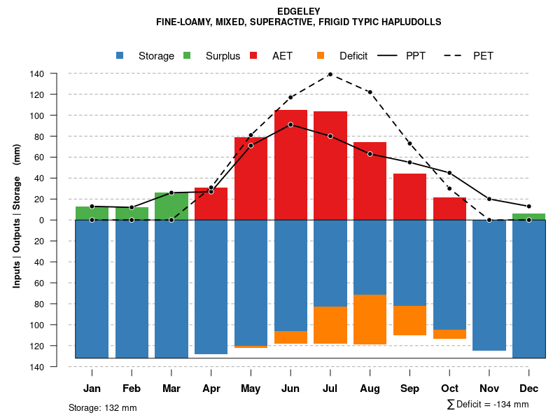
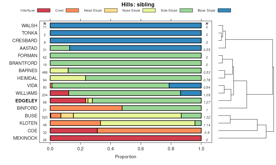
| Edgeley-Kloten-Buse loams, 9 to 35 percent slopes | G586F | 13039 | 2573634 | 2q5rw | nd003 | 1988 | 1:20000 |
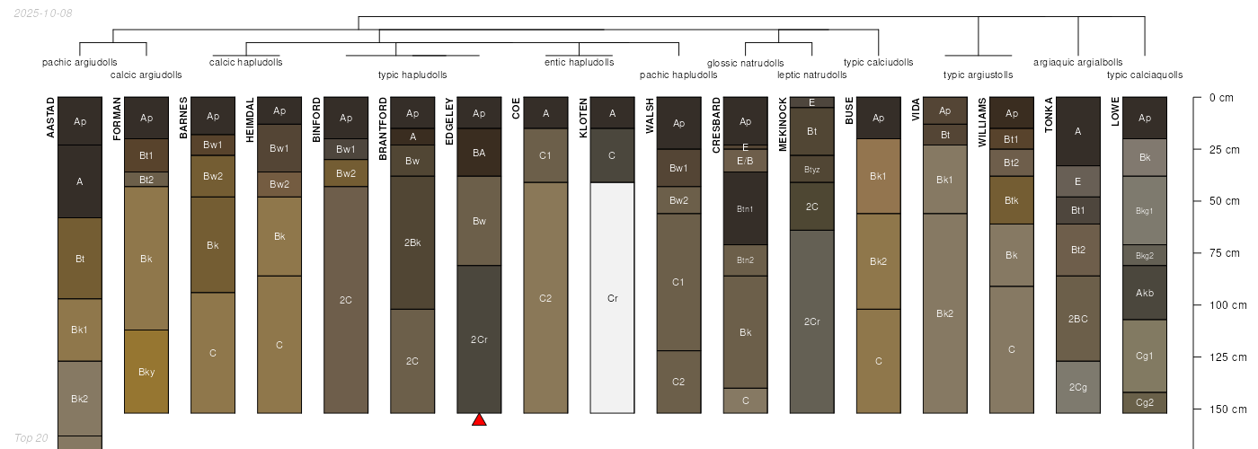
Edgeley loam, 2 to 6 percent slopes | G584B | 312 | 2573633 | 2q5rt | nd003 | 1988 | 1:20000 |
Heimdal-Edgeley-Esmond loams, 6 to 15 percent slopes | G585D | 885 | 2573793 | 2q5rv | nd005 | | 1:12000 |
Mekinock-Edgeley loams, 0 to 6 percent slopes | G582B | 871 | 2573747 | 2q5rq | nd005 | | 1:12000 |
Edgeley-Kloten-Buse loams, 9 to 35 percent slopes | G586F | 102 | 2573699 | 2q5rw | nd005 | | 1:12000 |
Kloten-Walsh-Edgeley loams, 6 to 35 percent slopes | F592F | 11800 | 2587576 | 2q5d8 | nd019 | 1987 | 1:20000 |
Mekinock-Edgeley loams, 0 to 6 percent slopes | G582B | 572 | 2903032 | 2q5rq | nd019 | 1987 | 1:20000 |
Edgeley loam, 0 to 2 percent slopes | G584A | 5922 | 2575360 | 2q5rs | nd021 | 1989 | 1:20000 |
Edgeley loam, 2 to 6 percent slopes | G584B | 2494 | 2575361 | 2q5rt | nd021 | 1989 | 1:20000 |
Edgeley-Kloten-Buse loams, 9 to 35 percent slopes | G586F | 1959 | 2576334 | 2q5rw | nd027 | | 1:12000 |
Mekinock-Edgeley loams, 0 to 6 percent slopes | G582B | 553 | 2576332 | 2q5rq | nd027 | | 1:12000 |
Heimdal-Edgeley-Esmond loams, 6 to 15 percent slopes | G585D | 1 | 2576333 | 2q5rv | nd027 | | 1:12000 |
Kloten-Walsh-Edgeley loams, 6 to 35 percent slopes | G592F | 2921 | 2576493 | 2q5rz | nd035 | 1980 | 1:20000 |
Mekinock-Edgeley loams, 0 to 6 percent slopes | G582B | 285 | 2576509 | 2q5rq | nd035 | 1980 | 1:20000 |
Kloten-Walsh-Edgeley loams, 6 to 35 percent slopes | F592F | 132 | 2587492 | 2q5d8 | nd035 | 1980 | 1:20000 |
Mekinock-Edgeley loams, 9 to 15 percent slopes | G582D | 68 | 2576522 | 2q5rr | nd035 | 1980 | 1:20000 |
Edgeley-Kloten-Buse loams, 9 to 35 percent slopes | G586F | 11080 | 2576650 | 2q5rw | nd039 | 1991 | 1:24000 |
Edgeley loam, 2 to 6 percent slopes | G584B | 1288 | 2576649 | 2q5rt | nd039 | 1991 | 1:24000 |
Edgeley loam, 0 to 2 percent slopes | G584A | 1074 | 2576648 | 2q5rs | nd039 | 1991 | 1:24000 |
Edgeley-Kloten loams, 6 to 9 percent slopes | G589C | 520 | 2576652 | 2q5ry | nd039 | 1991 | 1:24000 |
Edgeley loam, 0 to 2 percent slopes | G584A | 1938 | 2577111 | 2q5rs | nd045 | 1966 | 1:20000 |
Edgeley loam, 2 to 6 percent slopes | G584B | 871 | 2577112 | 2q5rt | nd045 | 1966 | 1:20000 |
Edgeley-Kloten-Buse loams, 9 to 35 percent slopes | G586F | 7248 | 2577354 | 2q5rw | nd063 | | 1:12000 |
Edgeley loam, 0 to 2 percent slopes | G584A | 1303 | 2577352 | 2q5rs | nd063 | | 1:12000 |
Edgeley-Kloten-Buse loams, 9 to 35 percent slopes | F586F | 574 | 2587306 | 2q5d3 | nd063 | | 1:12000 |
Kloten-Walsh-Edgeley loams, 6 to 35 percent slopes | G592F | 92 | 2577356 | 2q5rz | nd063 | | 1:12000 |
Edgeley loam, 2 to 6 percent slopes | G584B | 39 | 2577353 | 2q5rt | nd063 | | 1:12000 |
Edgeley-Kloten-Buse loams, 9 to 35 percent slopes | G586F | 22 | 2581199 | 2q5rw | nd073 | 1992 | 1:20000 |
Edgeley-Kloten-Buse loams, 9 to 35 percent slopes | G586F | 1855 | 2579775 | 2q5rw | nd091 | 1991 | 1:20000 |
Edgeley loam, 0 to 2 percent slopes | G584A | 684 | 2579774 | 2q5rs | nd091 | 1991 | 1:20000 |
Edgeley-Kloten-Buse loams, 9 to 35 percent slopes | G586F | 8633 | 2581399 | 2q5rw | nd093 | 1990 | 1:24000 |
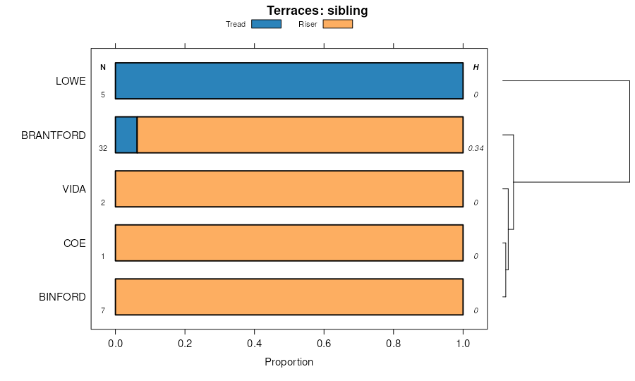
Kloten-Walsh-Edgeley loams, 6 to 35 percent slopes | F592F | 9792 | 2586168 | 2q5d8 | nd099 | 1967 | 1:20000 |
Edgeley loam, 0 to 2 percent slopes | F584A | 4949 | 2586164 | 2q5d0 | nd099 | 1967 | 1:20000 |
Edgeley loam, 2 to 6 percent slopes | F584B | 1209 | 2586165 | 2q5d1 | nd099 | 1967 | 1:20000 |
Edgeley-Kloten loams, 6 to 9 percent slopes | F589C | 576 | 2586167 | 2q5d4 | nd099 | 1967 | 1:20000 |
Edgeley-Kloten-Buse loams, 9 to 35 percent slopes | F586F | 218 | 2586166 | 2q5d3 | nd099 | 1967 | 1:20000 |
Buse-Kloten-Edgeley complex, 9 to 40 percent slopes | G583F | 3929 | 2797797 | 2sd4f | sd013 | 1987 | 1:20000 |
Zahl-Kloten west-Edgeley west, complex, 9 to 35 percent slopes | C967E | 3876 | 2765610 | 2rsrd | sd013 | 1987 | 1:20000 |
Edgeley-Kloten complex, west, 0 to 6 percent slopes | C947B | 1137 | 2765609 | 2rsrc | sd013 | 1987 | 1:20000 |
Edgeley-Kloten complex, 1 to 6 percent slopes | G589B | 362 | 2797799 | 2sd4k | sd013 | 1987 | 1:20000 |
Edgeley-Buse loams, 9 to 25 percent slopes | G584E | 60 | 2797798 | 2sd4j | sd013 | 1987 | 1:20000 |
Edgeley loam, 2 to 6 percent slopes | G584B | 53 | 2797695 | 2q5rt | sd013 | 1987 | 1:20000 |
Edgeley loam, west, 6 to 25 percent slopes | C946E | 4 | 2765601 | 2rsq1 | sd013 | 1987 | 1:20000 |
Buse-Kloten-Edgeley complex, 9 to 40 percent slopes | G583F | 733 | 2798514 | 2sd4f | sd037 | 1992 | 1:20000 |
Edgeley loam, 6 to 9 percent slopes | G584C | 187 | 2798515 | 2sd4g | sd037 | 1992 | 1:20000 |
Edgeley loam, 2 to 6 percent slopes | G584B | 87 | 2798466 | 2q5rt | sd037 | 1992 | 1:20000 |
Edgeley loam, west, 6 to 25 percent slopes | C946E | 727 | 2798606 | 2rsq1 | sd045 | 1973 | 1:20000 |
Zahl-Kloten west-Edgeley west, complex, 9 to 35 percent slopes | C967E | 119 | 2798615 | 2rsrd | sd045 | 1973 | 1:20000 |
Buse-Kloten-Edgeley complex, 9 to 40 percent slopes | G583F | 625 | 2799253 | 2sd4f | sd089 | 1980 | 1:20000 |
Edgeley loam, 9 to 15 percent slopes | G584D | 990 | 2799360 | 2sd4h | sd091 | 1970 | 1:20000 |
Edgeley loam, 6 to 9 percent slopes | G584C | 770 | 2799359 | 2sd4g | sd091 | 1970 | 1:20000 |
Buse-Kloten-Edgeley complex, 9 to 40 percent slopes | G583F | 668 | 2799358 | 2sd4f | sd091 | 1970 | 1:20000 |
Edgeley loam, 2 to 6 percent slopes | G584B | 193 | 2799311 | 2q5rt | sd091 | 1970 | 1:20000 |
Edgeley loam, 6 to 9 percent slopes | EdC | 151 | 416547 | fzg0 | sd091 | 1970 | 1:20000 |
Edgeley loam, 9 to 15 percent slopes | EdD | 134 | 416548 | fzg1 | sd091 | 1970 | 1:20000 |
Edgeley loam, 2 to 6 percent slopes | EdB | 129 | 416546 | fzfz | sd091 | 1970 | 1:20000 |
Edgeley loam, 6 to 9 percent slopes | G584C | 836 | 2799617 | 2sd4g | sd115 | 1997 | 1:24000 |
Edgeley-Buse loams, 9 to 25 percent slopes | G584E | 434 | 2799619 | 2sd4j | sd115 | 1997 | 1:24000 |
Edgeley loam, 9 to 15 percent slopes | G584D | 256 | 2799618 | 2sd4h | sd115 | 1997 | 1:24000 |
Edgeley loam, 2 to 6 percent slopes | G584B | 150 | 2799559 | 2q5rt | sd115 | 1997 | 1:24000 |


