| Eda-Tivoli sands, 1 to 12 percent slopes | 5447 | 4630 | 3156049 | 2yd7j | ks007 | 1973 | 1:24000 |
Eda-Tivoli sands, 1 to 12 percent slopes | 5447 | 26175 | 3156050 | 2yd7j | ks025 | 1980 | 1:24000 |
Eda-Tivoli sands, 1 to 12 percent slopes | 5447 | 15852 | 3156051 | 2yd7j | ks033 | 1987 | 1:24000 |
Eda sand, 3 to 8 percent slopes | PtC | 14168 | 381438 | 2sg37 | ok003 | 1971 | 1:24000 |
Eda sand, 0 to 3 percent slopes | PtB | 10363 | 381437 | 2s77b | ok003 | 1971 | 1:24000 |
Eda sand, 1 to 12 percent slopes | EdaE | 1 | 622540 | 2yd7h | ok003 | 1971 | 1:24000 |
Eda sand, 3 to 8 percent slopes | EdsD | 25 | 3109309 | 2sg37 | ok009 | 1978 | 1:24000 |
Eda-Tivoli sands, 1 to 12 percent slopes | EdsF | 3 | 381681 | 2yd7j | ok009 | 1978 | 1:24000 |
Eda sand, 0 to 3 percent slopes | PrB | 13236 | 381760 | 2s77b | ok011 | 1965 | 1:24000 |
Eda sand, 3 to 8 percent slopes | PrC | 8625 | 381761 | 2sg37 | ok011 | 1965 | 1:24000 |
Eda and Tivoli soils, 3 to 12 percent slopes | PvC | 5046 | 382245 | dtrh | ok033 | 1961 | 1:24000 |
Eda loamy fine sand, 0 to 3 percent slopes | PtB | 2379 | 382243 | dtrf | ok033 | 1961 | 1:24000 |
Eda sand, 3 to 8 percent slopes | PrC | 3842 | 382336 | 2sg37 | ok039 | 1973 | 1:24000 |
Eda-Tivoli complex, 5 to 12 percent slopes | PtE | 3134 | 382337 | 2sg3c | ok039 | 1973 | 1:24000 |
Eda sand, 0 to 3 percent slopes | PrB | 372 | 382335 | 2s77b | ok039 | 1973 | 1:24000 |
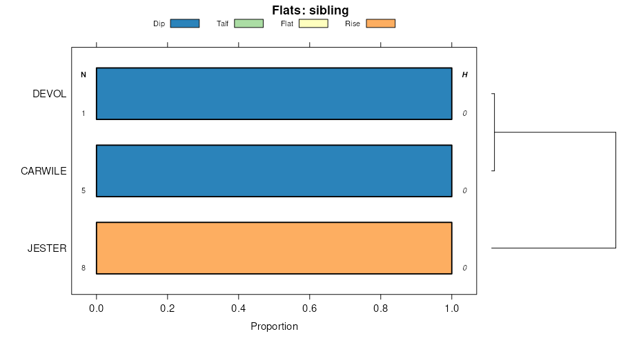
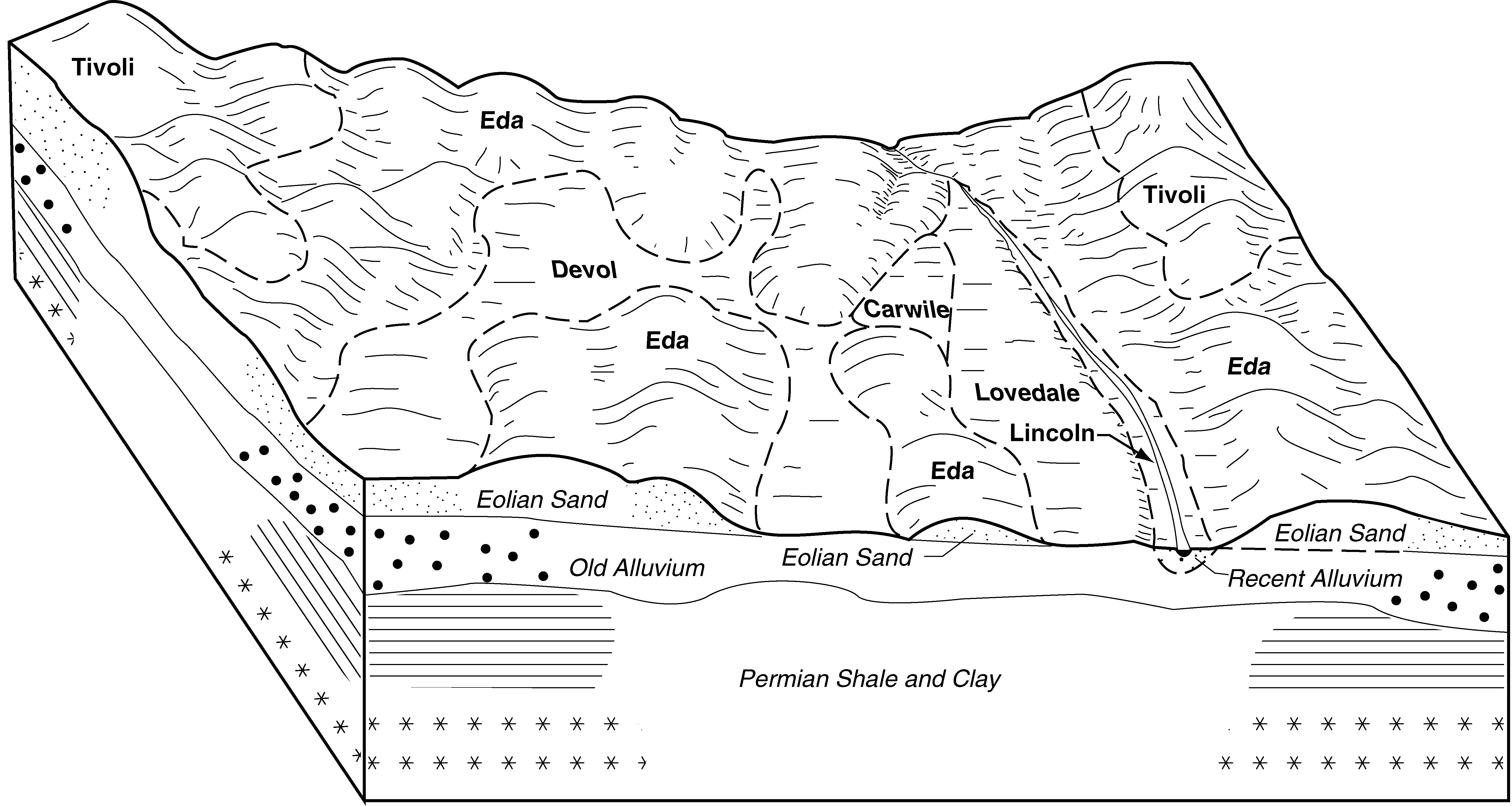
Carwile-Eda complex, 0 to 5 percent slopes | Cp | 9256 | 382360 | 2t6pt | ok043 | 1961 | 1:24000 |
Eda-Tivoli sands, 1 to 12 percent slopes | Pt | 7501 | 382390 | 2yd7j | ok043 | 1961 | 1:24000 |
Eda sand, 3 to 8 percent slopes | PpC | 6433 | 382387 | 2sg37 | ok043 | 1961 | 1:24000 |
Eda sand, 0 to 3 percent slopes | PpB | 1362 | 382386 | 2s77b | ok043 | 1961 | 1:24000 |
Carwile-Eda complex, 0 to 5 percent slopes | Cp | 6198 | 382424 | 2t6pt | ok045 | 1963 | 1:24000 |
Eda loamy fine sand, 0 to 3 percent slopes | PsB | 7359 | 382519 | dv1b | ok047 | 1965 | 1:24000 |
Eda loamy fine sand, 3 to 8 percent slopes | PtC | 6848 | 382520 | dv1c | ok047 | 1965 | 1:24000 |
Eda loamy fine sand, 3 to 5 percent slopes | 43 | 11847 | 382733 | dv87 | ok053 | 1983 | 1:24000 |
Eda sand, 3 to 8 percent slopes | EdsD | 7076 | 648155 | 2sg37 | ok055 | 2005 | 1:24000 |
Eda sand, 1 to 12 percent slopes | EdsF | 4305 | 648156 | 2yd7h | ok055 | 2005 | 1:24000 |
Eda sand, 0 to 3 percent slopes | EdsB | 1206 | 648154 | 2s77b | ok055 | 2005 | 1:24000 |
Eda sand, 1 to 12 percent slopes | EdlE | 20549 | 383041 | 2yd7h | ok059 | 1998 | 1:24000 |
Eda sand, 0 to 3 percent slopes | EdlC | 3466 | 383039 | 2s77b | ok059 | 1998 | 1:24000 |
Eda sand, 3 to 8 percent slopes | EdsD | 6269 | 392358 | 2sg37 | ok065 | 2000 | 1:24000 |
Eda sand, 0 to 3 percent slopes | EdsB | 3038 | 392357 | 2s77b | ok065 | 2000 | 1:24000 |
Eda sand, 1 to 12 percent slopes | EdsF | 1497 | 392359 | 2yd7h | ok065 | 2000 | 1:24000 |
Carwile, ponded-Eda complex, 0 to 3 percent slopes | CuB | 2260 | 383323 | dvw8 | ok071 | 1965 | 1:24000 |
Eda loamy fine sand, 3 to 8 percent slopes | PtC | 686 | 383359 | dvxf | ok071 | 1965 | 1:24000 |
Jester and Eda soils, 3 to 15 percent slopes | TpF | 3225 | 383489 | dw1m | ok075 | 1973 | 1:24000 |
Eda sand, 0 to 3 percent slopes | PtB | 22183 | 383849 | 2s77b | ok093 | 1965 | 1:24000 |
Eda sand, 3 to 8 percent slopes | PtC | 14168 | 383850 | 2sg37 | ok093 | 1965 | 1:24000 |
Nobscot-Eda complex, 5 to 20 percent slopes | NpD | 11064 | 383843 | 2t6pp | ok093 | 1965 | 1:24000 |
Eda-Tivoli sands, 1 to 12 percent slopes | PtD | 5799 | 383851 | 2yd7j | ok093 | 1965 | 1:24000 |
Nobscot-Eda complex, 3 to 5 percent slopes | NpC | 3246 | 383842 | 2t6pq | ok093 | 1965 | 1:24000 |
Eda sand, 1 to 12 percent slopes | PfE | 10878 | 384762 | 2yd7h | ok129 | 1961 | 1:24000 |
Eda sand, 0 to 3 percent slopes | PfB | 5792 | 384760 | 2s77b | ok129 | 1961 | 1:24000 |
Eda sand, 3 to 8 percent slopes | PfD | 940 | 384761 | 2sg37 | ok129 | 1961 | 1:24000 |
Eda sand, 5 to 12 percent slopes | 36 | 434 | 385021 | 2sg38 | ok149 | 1976 | 1:24000 |
Eda sand, 3 to 8 percent slopes | EdaD | 53312 | 385181 | 2sg37 | ok151 | 1995 | 1:24000 |
Eda sand, 0 to 3 percent slopes | EdaB | 15131 | 385180 | 2s77b | ok151 | 1995 | 1:24000 |
Eda sand, 1 to 12 percent slopes | EdaE | 10343 | 385182 | 2yd7h | ok151 | 1995 | 1:24000 |
Eda-Tivoli sands, 1 to 12 percent slopes | Pt | 61612 | 385294 | 2yd7j | ok153 | 1961 | 1:24000 |
Eda sand, 3 to 8 percent slopes | PfC | 54872 | 385293 | 2sg37 | ok153 | 1961 | 1:24000 |
Nobscot-Eda complex, 5 to 20 percent slopes | NpE | 18057 | 385287 | 2t6pp | ok153 | 1961 | 1:24000 |
Eda sand, 0 to 3 percent slopes | PfB | 16356 | 385292 | 2s77b | ok153 | 1961 | 1:24000 |
Carwile-Eda complex, 0 to 5 percent slopes | Cp | 15961 | 385267 | 2t6pt | ok153 | 1961 | 1:24000 |
Nobscot-Eda complex, 3 to 5 percent slopes | NpC | 5148 | 385286 | 2t6pq | ok153 | 1961 | 1:24000 |