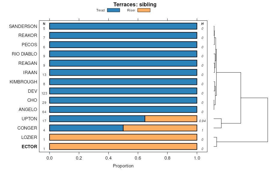
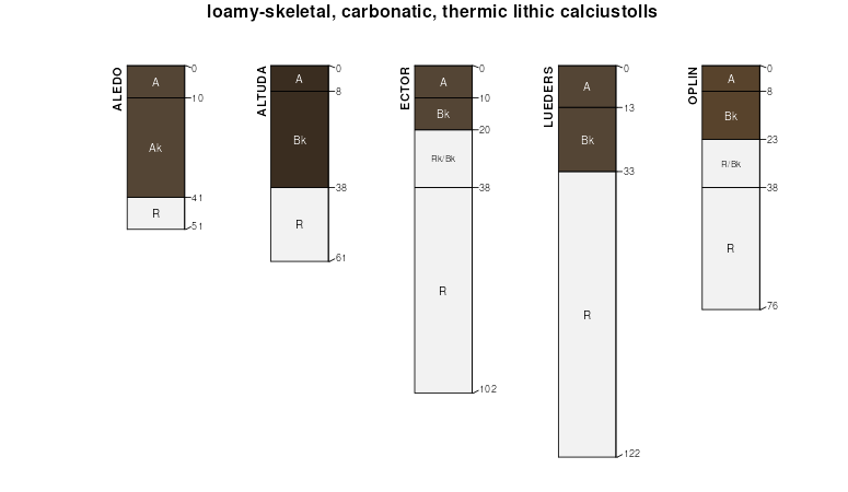
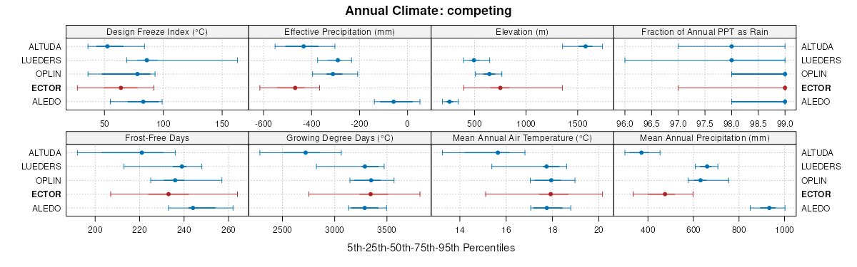
| Ector stony loam, 0 to 9 percent slopes | EC | 182255 | 55872 | 1w4b | nm614 | 1966 | 1:20000 |
Ector extremely rocky loam, 9 to 25 percent slopes | EE | 140696 | 55873 | 1w4c | nm614 | 1966 | 1:20000 |
Ector-Reagan association, 0 to 9 percent slopes | ER | 87892 | 55874 | 1w4d | nm614 | 1966 | 1:20000 |
Russler-Ector association, 0 to 9 percent slopes | RU | 2706 | 55910 | 1w5k | nm614 | 1966 | 1:20000 |
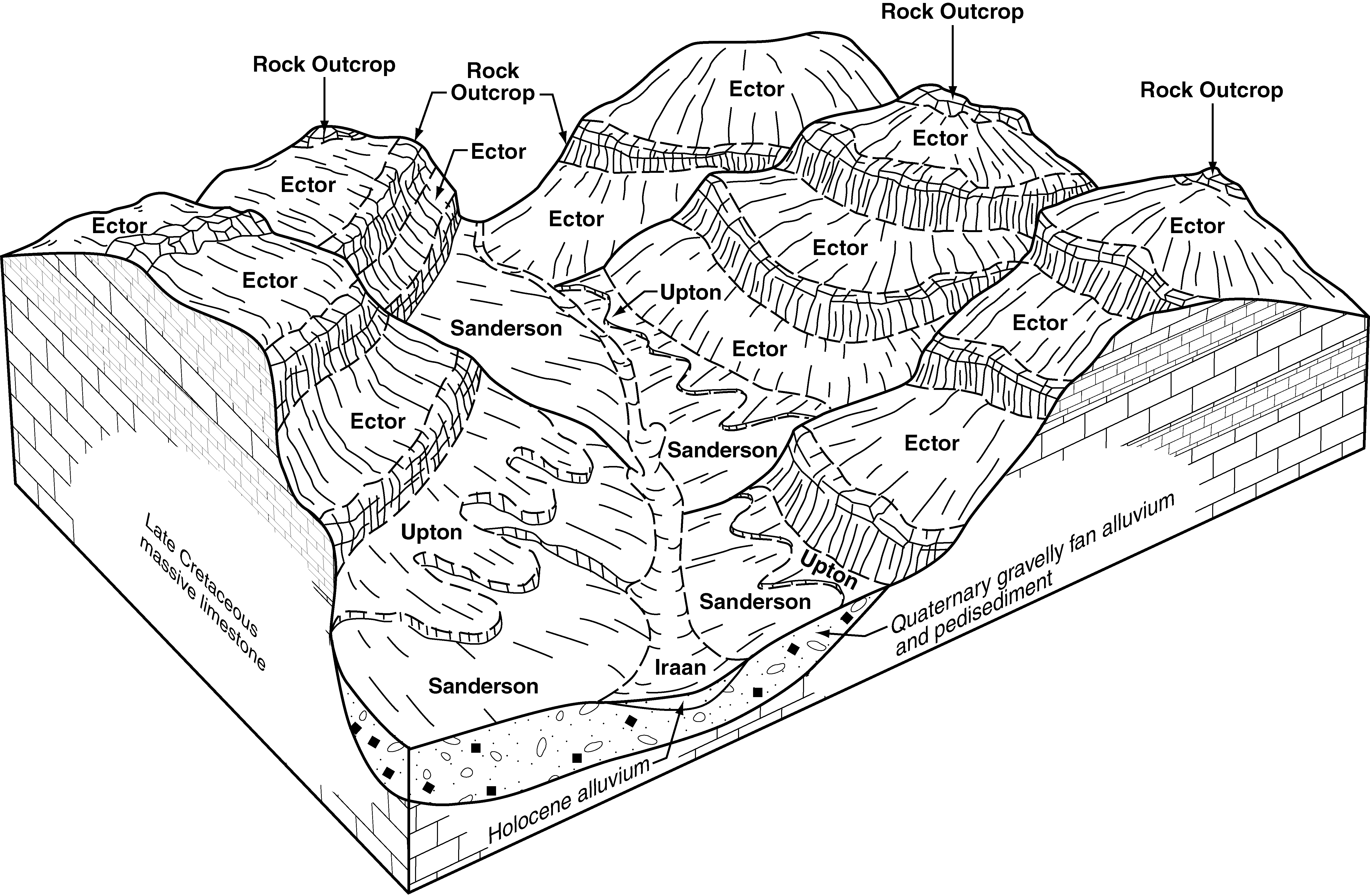
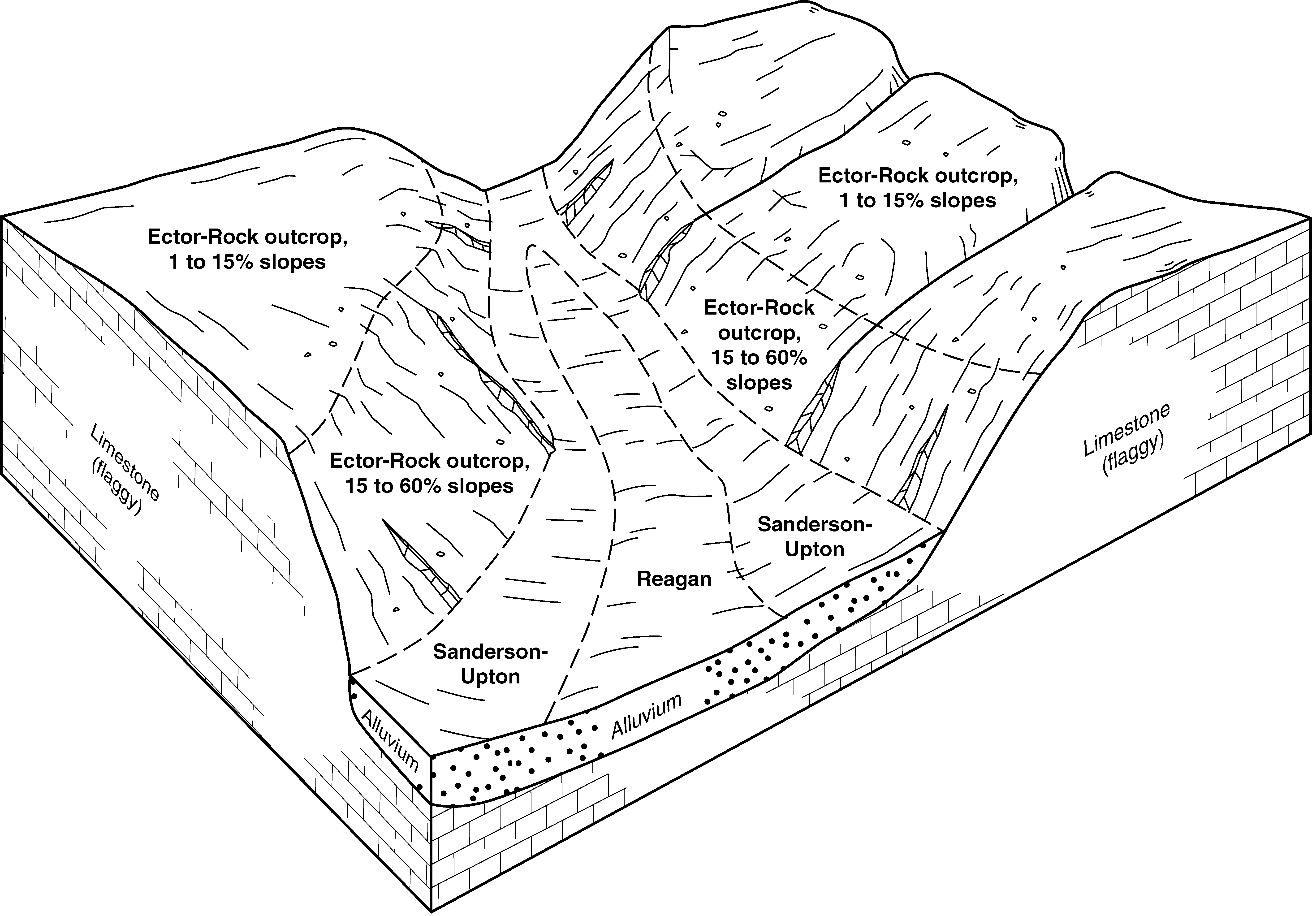
Ector-Rock outcrop association, moderately sloping | 17 | 56565 | 375574 | dlt9 | nm632 | 1981 | 1:63360 |
Ector-Rock outcrop association, moderately steep | 18 | 46538 | 375575 | dltb | nm632 | 1981 | 1:63360 |
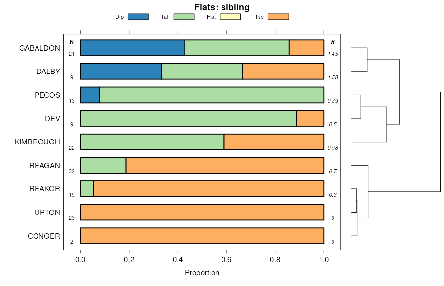
Ector-Kimbrough association, gently sloping | 16 | 32046 | 375573 | dlt8 | nm632 | 1981 | 1:63360 |
Ector very cobbly loam, 3 to 15 percent slopes | EaC | 60927 | 375759 | dm08 | nm644 | 1981 | 1:24000 |
Ector very cobbly loam, dry, 3 to 15 percent slopes | EbC | 48485 | 375760 | dm09 | nm644 | 1981 | 1:24000 |
Ector-Rock outcrop complex, dry, hilly | ESD | 28619 | 375758 | dm07 | nm644 | 1981 | 1:24000 |
Ector-Conger association, moderately rolling | ECC | 10970 | 375756 | dm05 | nm644 | 1981 | 1:24000 |
Upton-Ector, dry association, moderately rolling | UEC | 6754 | 375824 | dm2c | nm644 | 1981 | 1:24000 |
Kimbrough, dry-Ector association, moderately undulating | KEC | 6681 | 375781 | dm0z | nm644 | 1981 | 1:24000 |
Ector-Rock outcrop complex, hilly | ERD | 5500 | 375757 | dm06 | nm644 | 1981 | 1:24000 |
Ector-Rock outcrop complex, 20 to 50 percent slopes | ECF | 82809 | 635644 | pbfn | nm646 | 1976 | 1:24000 |
Ector-Rock outcrop complex, 9 to 30 percent slopes | EcD | 270928 | 55955 | 1w70 | nm666 | 1974 | 1:24000 |
Ector-Rock outcrop complex, 0 to 9 percent slopes | EcC | 158189 | 55954 | 1w6z | nm666 | 1974 | 1:24000 |
Ector-Rock outcrop complex, moist, 1 to 20 percent slopes | ERD | 377840 | 364669 | 2t0rq | tx105 | 2002 | 1:31680 |
Ector-Rock outcrop complex, moist, 10 to 60 percent slopes | ERG | 270506 | 364671 | 2t2jl | tx105 | 2002 | 1:31680 |
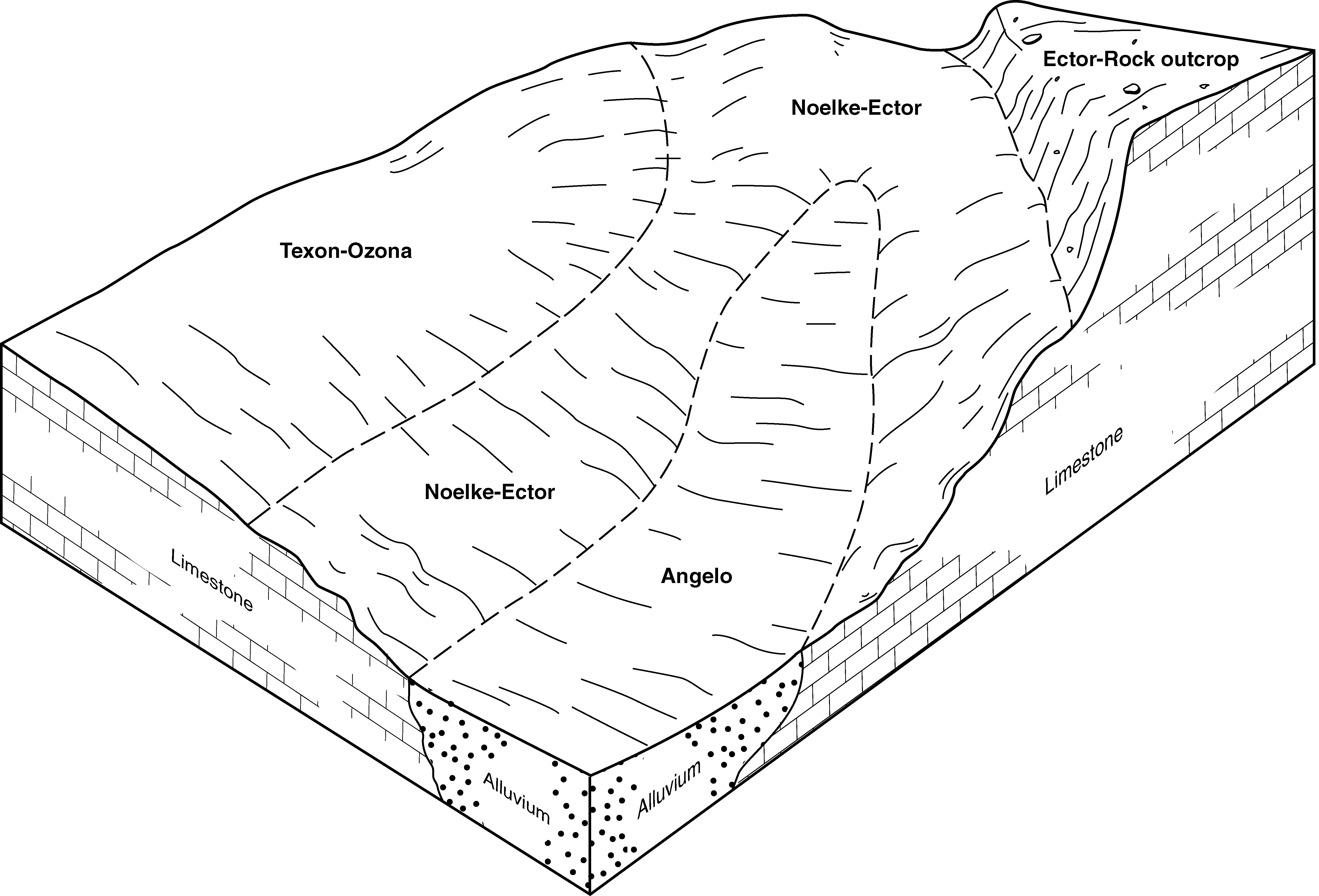
Noelke-Ector complex, 0 to 5 percent slopes | NoD | 260691 | 364658 | d7g5 | tx105 | 2002 | 1:31680 |
Ector soils, moist, 1 to 8 percent slopes | ECD | 51231 | 366237 | 2t2jc | tx173 | 1974 | 1:31680 |
Ector soils, moist, 1 to 8 percent slopes | Ec | 16464 | 391883 | 2t2jc | tx227 | 1965 | 1:24000 |
Ector-Rock outcrop complex | Er | 16456 | 391884 | f4sf | tx227 | 1965 | 1:24000 |
Ector soils, very steep | Rs | 7290 | 391907 | f4t5 | tx227 | 1965 | 1:24000 |
Ector soils, moist, 1 to 8 percent slopes | EGB | 187972 | 367957 | 2t2jc | tx235 | 1982 | 1:31680 |
Ector soils, moist, 3 to 30 percent slopes | ESE | 45813 | 367958 | 2t2jg | tx235 | 1982 | 1:31680 |
Rock Outcrop-Ector, warm, complex, 10 to 40 percent slopes | Lr | 106577 | 368699 | 2t2jm | tx271 | 1965 | 1:20000 |
Ector soils, warm, 1 to 8 percent slopes | Ec | 55581 | 368688 | 2t0rn | tx271 | 1965 | 1:20000 |
Ector-Rock outcrop complex, warm, 5 to 20 percent slopes | Et | 28044 | 368689 | 2t275 | tx271 | 1965 | 1:20000 |
Ector-Rock outcrop complex, 10 to 60 percent slopes | 9 | 546134 | 58525 | 2t270 | tx371 | 1977 | 1:31680 |
Ector-Rock outcrop association, 1 to 15 percent slopes | 8 | 204894 | 58524 | 2t0rd | tx371 | 1977 | 1:31680 |
Ector-Upton association, 0 to 5 percent slopes | 10 | 125771 | 58499 | 2t0rw | tx371 | 1977 | 1:31680 |
Ector soils, moist, 1 to 8 percent slopes | 4 | 58338 | 371994 | 2t2jc | tx413 | 1977 | 1:31680 |
Ector soils, moist, 1 to 8 percent slopes | ECD | 136895 | 372240 | 2t2jc | tx431 | 1974 | 1:31680 |
Ector soils, moist, 3 to 30 percent slopes | ECG | 67235 | 372241 | 2t2jg | tx431 | 1974 | 1:31680 |
Ector-Rock outcrop complex, moist, 10 to 60 percent slopes | Er | 43996 | 372319 | 2t2jl | tx435 | 1965 | 1:20000 |
Ector soils, moist, 1 to 8 percent slopes | Es | 10926 | 372320 | 2t2jc | tx435 | 1965 | 1:20000 |
Ector-Rock outcrop complex, 10 to 60 percent slopes | Er | 354183 | 372518 | 2t270 | tx443 | 1964 | 1:31680 |
Ector-Rock outcrop association, 1 to 15 percent slopes | Ec | 207425 | 372517 | 2t0rd | tx443 | 1964 | 1:31680 |
Ector-Upton association, 0 to 5 percent slopes | Eu | 180165 | 372519 | 2t0rw | tx443 | 1964 | 1:31680 |
Ector soils, moist, 3 to 30 percent slopes | EcE | 47659 | 372739 | 2t2jg | tx451 | 1971 | 1:20000 |
Ector soils, moist, 1 to 8 percent slopes | EcC | 34590 | 372738 | 2t2jc | tx451 | 1971 | 1:20000 |
Rock Outcrop-Ector, warm, complex, 10 to 40 percent slopes | LS | 79648 | 372902 | 2t2jm | tx463 | 1970 | 1:24000 |
Ector-Rock outcrop complex, warm, 5 to 20 percent slopes | ERE | 50198 | 372891 | 2t275 | tx463 | 1970 | 1:24000 |
Ector soils, warm, 1 to 8 percent slopes | EOB | 40065 | 372890 | 2t0rn | tx463 | 1970 | 1:24000 |
Ector-Rock outcrop complex, moist, 10 to 60 percent slopes | ERG | 561777 | 372943 | 2t2jl | tx465 | 1980 | 1:24000 |
Ector-Rock outcrop complex, moist, 1 to 20 percent slopes | ERF | 363964 | 372942 | 2t0rq | tx465 | 1980 | 1:24000 |
Ector-Rock outcrop complex, moist, 10 to 60 percent slopes | ErG | 121081 | 374296 | 2t2jl | tx607 | 2000 | 1:31680 |
Ector-Rock outcrop complex, moist, 1 to 20 percent slopes | ErF | 21151 | 374295 | 2t0rq | tx607 | 2000 | 1:31680 |
Ector gravelly silty clay loam, 1 to 3 percent slopes | ErB | 7364 | 374294 | dkh0 | tx607 | 2000 | 1:31680 |
Ector soils, moist, 1 to 8 percent slopes | ECC | 71531 | 374703 | 2t2jc | tx618 | 1989 | 1:31680 |
Ector very gravelly loam, 8 to 30 percent slopes, very stony | ECE | 18216 | 374704 | dkx7 | tx618 | 1989 | 1:31680 |
Ector-Rock outcrop complex, 10 to 60 percent slopes | ERG | 47409 | 58846 | 2t270 | tx622 | 1998 | 1:31680 |
Ector-Upton association, 0 to 5 percent slopes | ETB | 6912 | 58847 | 2t0rw | tx622 | 1998 | 1:31680 |