| Eckman silt loam, 1 to 6 percent slopes | J15B | 11689 | 2423035 | 2xpp8 | mn023 | 1980 | 1:15840 |
Zell-Eckman complex, 2 to 6 percent slopes | J38B | 329 | 2423050 | 2mbcx | mn023 | 1980 | 1:15840 |
Zell-Eckman complex, 6 to 12 percent slopes, moderately eroded | J38C2 | 35 | 2423051 | 2mbcy | mn023 | 1980 | 1:15840 |
Eckman silt loam, 1 to 6 percent slopes | RoB | 1228 | 397317 | 2xpp8 | mn041 | 1970 | 1:12000 |
Eckman silt loam, 1 to 6 percent slopes | 290B | 970 | 398032 | 2xpp8 | mn051 | 1974 | 1:20000 |
Eckman silt loam, 1 to 6 percent slopes | 290B | 5379 | 430282 | 2xpp8 | mn073 | 1994 | 1:20000 |
Eckman silt loam, 1 to 6 percent slopes | 290B | 1150 | 399222 | 2xpp8 | mn087 | 1992 | 1:20000 |
Eckman silt loam, 1 to 6 percent slopes | 290 | 1333 | 435686 | 2xpp8 | mn111 | 1996 | 1:20000 |
Zell-Eckman silt loams, 15 to 25 percent slopes | I202E | 3800 | 2799688 | 1nyrx | mn119 | 1996 | 1:20000 |
Eckman very fine sandy loam, 1 to 4 percent slopes | I856A | 265 | 2799923 | 2ql13 | mn149 | 1966 | 1:15840 |
Eckman silt loam, 1 to 6 percent slopes | EcB | 226 | 428332 | 2xpp8 | mn149 | 1966 | 1:15840 |
Zell-Eckman complex, 2 to 6 percent slopes | J38B | 1217 | 434821 | glgh | mn151 | 2000 | 1:12000 |
Eckman silt loam, 1 to 6 percent slopes | J15B | 879 | 434787 | 2xpp8 | mn151 | 2000 | 1:12000 |
Zell-Eckman complex, 6 to 12 percent slopes, eroded | J38C2 | 326 | 434822 | glgj | mn151 | 2000 | 1:12000 |
Eckman silt loam, 1 to 6 percent slopes | 290B | 1011 | 357412 | 2xpp8 | mn167 | 1985 | 1:20000 |
Zell-Eckman complex, 6 to 12 percent slopes, moderately eroded | J38C2 | 527 | 1654000 | 1sj3v | mn173 | 1979 | 1:20000 |
Eckman silt loam, 1 to 6 percent slopes | J15B | 314 | 3026614 | 2xpp8 | mn173 | 1979 | 1:20000 |
Zell-Eckman complex, 2 to 6 percent slopes | J38B | 135 | 1653999 | 1sj3t | mn173 | 1979 | 1:20000 |
Zell-Eckman loams, 15 to 25 percent slopes | G486E | 1090 | 2573619 | 2q5nw | nd003 | 1988 | 1:20000 |
Eckman-Zell loams, 6 to 9 percent slopes | G486C | 1062 | 2573618 | 2q5nt | nd003 | 1988 | 1:20000 |
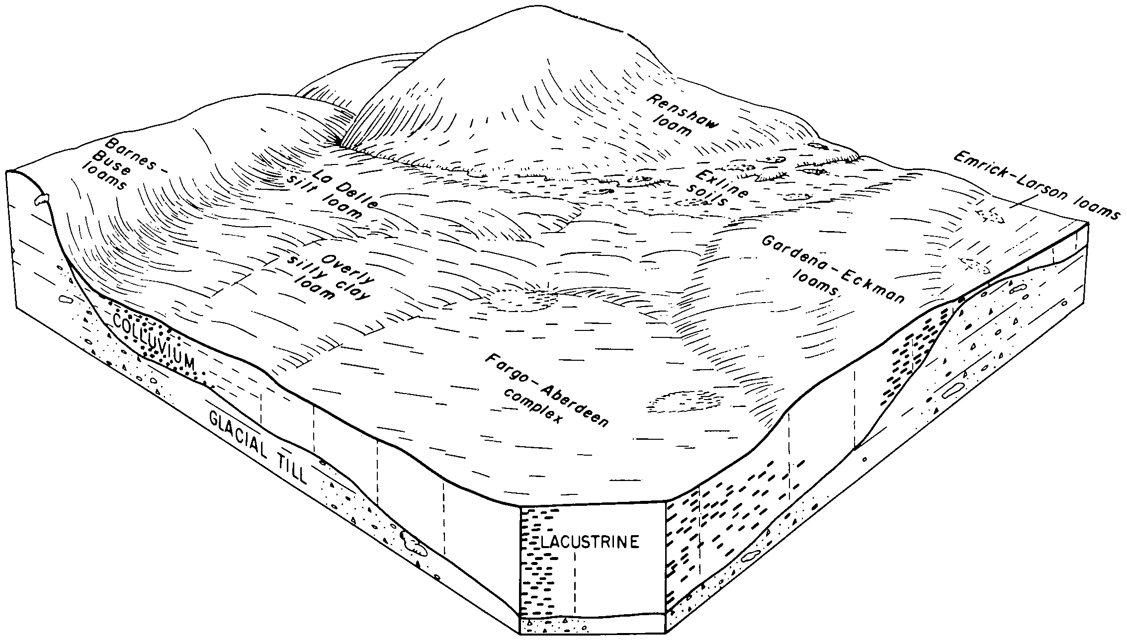
Gardena-Eckman loams, 2 to 6 percent slopes | F486B | 1020 | 2587768 | 2q565 | nd005 | | 1:12000 |
Eckman-Zell loams, 6 to 9 percent slopes | F486C | 743 | 2587611 | 2q566 | nd005 | | 1:12000 |
Gardena-Eckman loams, 2 to 6 percent slopes | G486B | 280 | 2573680 | 2q5ns | nd005 | | 1:12000 |
Eckman-Zell loams, 6 to 9 percent slopes | G486C | 8 | 2573730 | 2q5nt | nd005 | | 1:12000 |
Gardena-Eckman loams, 2 to 6 percent slopes | F486B | 7942 | 2586076 | 2q565 | nd009 | 1981 | 1:20000 |
Zell-Eckman silt loams, 15 to 25 percent slopes | I202E | 3613 | 2640902 | 1nyrx | nd017 | 1983 | 1:20000 |
Eckman-Zell complex, 6 to 9 percent slopes | I201C | 515 | 2521596 | 2qkv4 | nd017 | 1983 | 1:20000 |
Eckman-Zell loams, 2 to 6 percent slopes | I521B | 171 | 2640834 | 1tbnr | nd017 | 1983 | 1:20000 |
Eckman-Gardena loams, 2 to 6 percent slopes | I493B | 82 | 2640898 | 1tbn7 | nd017 | 1983 | 1:20000 |
Zell-Eckman silt loams, 9 to 15 percent slopes | I202D | 46 | 2640891 | 1nyrw | nd017 | 1983 | 1:20000 |
Gardena-Eckman loams, 2 to 6 percent slopes | G486B | 1775 | 2575347 | 2q5ns | nd021 | 1989 | 1:20000 |
Gardena-Eckman loams, 0 to 2 percent slopes | G486A | 253 | 2576318 | 2q5nr | nd027 | | 1:12000 |
Gardena-Eckman loams, 2 to 6 percent slopes | G486B | 74 | 2576319 | 2q5ns | nd027 | | 1:12000 |
Gardena-Eckman silt loams, 2 to 6 percent slopes | I202B | 22 | 2642533 | 1nyrt | nd035 | 1980 | 1:20000 |
Zell-Eckman silt loams, 9 to 15 percent slopes | I202D | 1 | 2642534 | 1nyrw | nd035 | 1980 | 1:20000 |
Gardena-Eckman loams, 2 to 6 percent slopes | G486B | 2586 | 2576632 | 2q5ns | nd039 | 1991 | 1:24000 |
Eckman-Zell loams, 6 to 9 percent slopes | G486C | 1456 | 2576633 | 2q5nt | nd039 | 1991 | 1:24000 |
Zell-Eckman loams, 9 to 15 percent slopes | G486D | 458 | 2576634 | 2q5nv | nd039 | 1991 | 1:24000 |
Zell-Eckman loams, 15 to 25 percent slopes | G486E | 106 | 2576635 | 2q5nw | nd039 | 1991 | 1:24000 |
Gardena-Eckman loams, 0 to 2 percent slopes | G486A | 3132 | 2577089 | 2q5nr | nd045 | 1966 | 1:20000 |
Gardena-Eckman loams, 2 to 6 percent slopes | G486B | 750 | 2577090 | 2q5ns | nd045 | 1966 | 1:20000 |
Eckman-Zell loams, 6 to 9 percent slopes | G486C | 41 | 2577091 | 2q5nt | nd045 | 1966 | 1:20000 |
Gardena-Eckman loams, 2 to 6 percent slopes | G486B | 782 | 2577339 | 2q5ns | nd063 | | 1:12000 |
Zell-Eckman silt loams, 9 to 15 percent slopes | I202D | 258 | 2642950 | 1nyrw | nd067 | 1972 | 1:20000 |
Gardena-Eckman loams, 2 to 6 percent slopes | F486B | 7277 | 2587293 | 2q565 | nd069 | 1975 | 1:20000 |
Eckman-Zell loams, 6 to 9 percent slopes | F486C | 787 | 2587182 | 2q566 | nd069 | 1975 | 1:20000 |
Gardena-Eckman loams, 0 to 2 percent slopes | G486A | 1395 | 2581179 | 2q5nr | nd073 | 1992 | 1:20000 |
Eckman-Zell loams, 2 to 6 percent slopes | G478B | 1170 | 2581177 | 2q5nk | nd073 | 1992 | 1:20000 |
Zell-Eckman silt loams, 15 to 25 percent slopes | I202E | 509 | 2641268 | 1nyrx | nd073 | 1992 | 1:20000 |
Eckman-Zell complex, 6 to 9 percent slopes | I201C | 421 | 2641360 | 2qkv4 | nd073 | 1992 | 1:20000 |
Gardena-Eckman loams, 2 to 6 percent slopes | G486B | 379 | 2581180 | 2q5ns | nd073 | 1992 | 1:20000 |
Eckman-Gardena loams, 2 to 6 percent slopes | I493B | 347 | 2641335 | 1tbn7 | nd073 | 1992 | 1:20000 |
Eckman-Zell loams, 6 to 9 percent slopes | G486C | 123 | 2581181 | 2q5nt | nd073 | 1992 | 1:20000 |
Gardena-Eckman loams, 0 to 2 percent slopes | I493A | 66 | 2641336 | 1tbn8 | nd073 | 1992 | 1:20000 |
Gardena-Eckman silt loams, 2 to 6 percent slopes | I202B | 5196 | 2641153 | 1nyrt | nd077 | 2005 | 1:12000 |
Eckman-Zell complex, 6 to 9 percent slopes | I201C | 2120 | 2640975 | 2qkv4 | nd077 | 2005 | 1:12000 |
Zell-Eckman silt loams, 9 to 15 percent slopes | I202D | 1573 | 2641116 | 1nyrw | nd077 | 2005 | 1:12000 |
Zell-Eckman silt loams, 15 to 25 percent slopes | I202E | 781 | 2641134 | 1nyrx | nd077 | 2005 | 1:12000 |
Eckman-Gardena loams, 2 to 6 percent slopes | I493B | 10 | 2641129 | 1tbn7 | nd077 | 2005 | 1:12000 |
Eckman-Zell loams, 6 to 9 percent slopes | G486C | 5 | 2577405 | 2q5nt | nd077 | 2005 | 1:12000 |
Gardena-Eckman loams, 0 to 2 percent slopes | F486A | 1962 | 2588113 | 2q564 | nd079 | 1990 | 1:24000 |
Gardena-Eckman loams, 2 to 6 percent slopes | F486B | 420 | 2588218 | 2q565 | nd079 | 1990 | 1:24000 |
Gardena-Eckman loams, 2 to 6 percent slopes | G486B | 3229 | 2579434 | 2q5ns | nd081 | 1959 | 1:12000 |
Gardena-Eckman silt loams, 2 to 6 percent slopes | I202B | 368 | 2641193 | 1nyrt | nd081 | 1959 | 1:12000 |
Gardena-Eckman loams, 0 to 2 percent slopes | G486A | 314 | 2579574 | 2q5nr | nd081 | 1959 | 1:12000 |
Eckman-Zell complex, 6 to 9 percent slopes | I201C | 247 | 2641266 | 2qkv4 | nd081 | 1959 | 1:12000 |
Eckman-Zell loams, 6 to 9 percent slopes | G486C | 217 | 2579473 | 2q5nt | nd081 | 1959 | 1:12000 |
Eckman and Maddock loams, undulating | EmB | 97 | 341575 | cgfk | nd081 | 1959 | 1:12000 |
Zell-Eckman silt loams, 9 to 15 percent slopes | I202D | 84 | 2641194 | 1nyrw | nd081 | 1959 | 1:12000 |
Eckman silt loam, 1 to 6 percent slopes | EcB | 47 | 341574 | 2xpp8 | nd081 | 1959 | 1:12000 |
Eckman and Maddock loams, rolling | EmC | 2 | 341576 | cgfl | nd081 | 1959 | 1:12000 |
Zell-Eckman silt loams, 15 to 25 percent slopes | I202E | 119 | 2641365 | 1nyrx | nd091 | 1991 | 1:20000 |
Gardena-Eckman silt loams, 2 to 6 percent slopes | I202B | 19 | 2641364 | 1nyrt | nd091 | 1991 | 1:20000 |
Zell-Eckman silt loams, 15 to 25 percent slopes | I202E | 1089 | 2641575 | 1nyrx | nd097 | 1974 | 1:20000 |
Gardena-Eckman silt loams, 2 to 6 percent slopes | I202B | 918 | 2641573 | 1nyrt | nd097 | 1974 | 1:20000 |
Eckman-Zell complex, 6 to 9 percent slopes | I201C | 514 | 2642508 | 2qkv4 | nd097 | 1974 | 1:20000 |
Zell-Eckman silt loams, 9 to 15 percent slopes | I202D | 77 | 2641574 | 1nyrw | nd097 | 1974 | 1:20000 |
Gardena-Eckman silt loams, 2 to 6 percent slopes | I202B | 351 | 2509497 | 1nyrt | nd099 | 1967 | 1:20000 |
Zell-Eckman silt loams, 9 to 15 percent slopes | I202D | 174 | 2509498 | 1nyrw | nd099 | 1967 | 1:20000 |
Gardena-Eckman loams, 0 to 2 percent slopes | G486A | 3345 | 2579665 | 2q5nr | nd103 | 1966 | 1:12000 |
Eckman-Gardena very fine sandy loams, 0 to 2 percent slopes | G493A | 13152 | 2797779 | 2sd3q | sd013 | 1987 | 1:20000 |
Eckman-Gardena very fine sandy loams, 2 to 6 percent slopes | G493B | 13099 | 2797780 | 2sd3r | sd013 | 1987 | 1:20000 |
Eckman-Zell very fine sandy loams, 2 to 6 percent slopes | G495B | 1316 | 2797781 | 2sd3s | sd013 | 1987 | 1:20000 |
Eckman-Gardena very fine sandy loams, 0 to 2 percent slopes | G493A | 45 | 2798498 | 2sd3q | sd037 | 1992 | 1:20000 |
Eckman-Gardena very fine sandy loams, 2 to 6 percent slopes | G493B | 8 | 2798499 | 2sd3r | sd037 | 1992 | 1:20000 |
Eckman-Zell very fine sandy loams, 2 to 6 percent slopes | G495B | 7 | 2798500 | 2sd3s | sd037 | 1992 | 1:20000 |
Zell-Eckman complex, 6 to 12 percent slopes | ZrC | 333 | 416914 | fztv | sd039 | 1992 | 1:20000 |
Eckman loam, 2 to 6 percent slopes | EcB | 330 | 416849 | fzrr | sd039 | 1992 | 1:20000 |
Eckman-Gardena very fine sandy loams, 0 to 2 percent slopes | G493A | 293 | 2799344 | 2sd3q | sd091 | 1970 | 1:20000 |
Eckman-Gardena very fine sandy loams, 2 to 6 percent slopes | G493B | 225 | 2799345 | 2sd3r | sd091 | 1970 | 1:20000 |
Gardena-Eckman loams, 2 to 6 percent slopes | G486B | 17 | 2799304 | 2q5ns | sd091 | 1970 | 1:20000 |
Eckman silt loam, 1 to 6 percent slopes | EcB | 8390 | 417815 | 2xpp8 | sd109 | 1977 | 1:20000 |
Gardena-Eckman loams, 0 to 2 percent slopes | I493A | 1470 | 2800205 | 1tbn8 | sd109 | 1977 | 1:20000 |
Eckman-Zell complex, 6 to 9 percent slopes | EeC | 1030 | 417816 | g0ry | sd109 | 1977 | 1:20000 |
Eckman-Gardena loams, 2 to 6 percent slopes | I493B | 624 | 2800204 | 1tbn7 | sd109 | 1977 | 1:20000 |
Zell-Eckman silt loams, 9 to 15 percent slopes | I202D | 415 | 2800163 | 1nyrw | sd109 | 1977 | 1:20000 |
Zell-Eckman complex, 9 to 25 percent slopes | ZeD | 149 | 417886 | g0v6 | sd109 | 1977 | 1:20000 |
Eckman-Zell complex, 6 to 9 percent slopes | I201C | 35 | 2800232 | 2qkv4 | sd109 | 1977 | 1:20000 |
Gardena-Eckman silt loams, 2 to 6 percent slopes | I202B | 7 | 2800162 | 1nyrt | sd109 | 1977 | 1:20000 |
Zell-Eckman silt loams, 15 to 25 percent slopes | I202E | 6 | 2800164 | 1nyrx | sd109 | 1977 | 1:20000 |
Eckman-Gardena very fine sandy loams, 0 to 2 percent slopes | G493A | 3571 | 2799603 | 2sd3q | sd115 | 1997 | 1:24000 |
Eckman-Zell very fine sandy loams, 2 to 6 percent slopes | G495B | 1391 | 2799605 | 2sd3s | sd115 | 1997 | 1:24000 |
Eckman-Gardena very fine sandy loams, 2 to 6 percent slopes | G493B | 738 | 2799604 | 2sd3r | sd115 | 1997 | 1:24000 |


