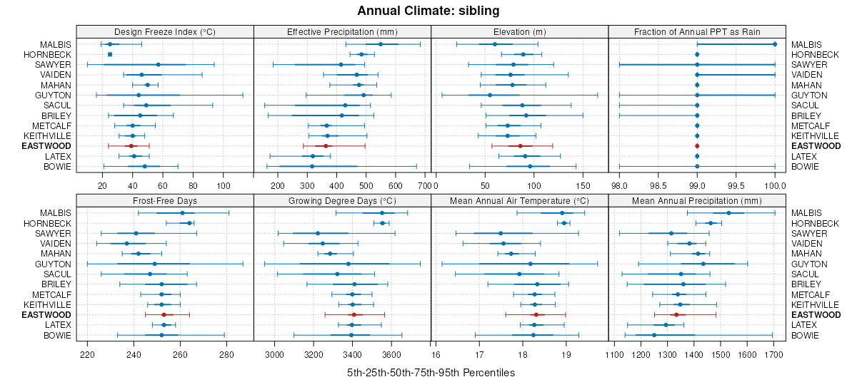
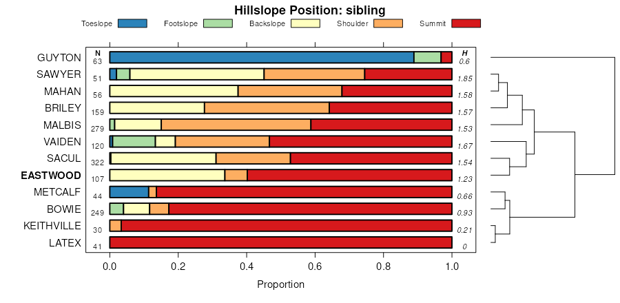
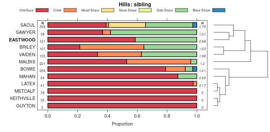
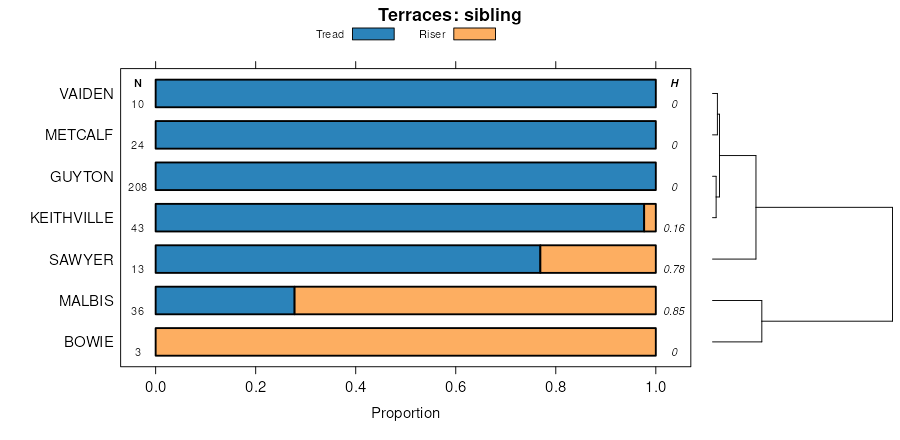
| Eastwood fine sandy loam, 5 to 12 percent slopes | ECE | 6193 | 1724581 | 2tcnv | la013 | 1992 | 1:24000 |
Eastwood fine sandy loam, 1 to 5 percent slopes | EcC | 5242 | 1724583 | 30d19 | la013 | 1992 | 1:24000 |
Eastwood fine sandy loam, 12 to 20 percent slopes | ECF | 4956 | 1724582 | 1vwkp | la013 | 1992 | 1:24000 |
Eastwood fine sandy loam, 5 to 15 percent slopes | EaG | 46463 | 2805710 | 2ssx3 | la017 | 2013 | 1:24000 |
Eastwood fine sandy loam, 1 to 5 percent slopes | EaC | 26140 | 2805709 | 30d19 | la017 | 2013 | 1:24000 |
Urban land-Eastwood complex, 5 to 15 percent slopes | UED | 7877 | 2805748 | 2ssy6 | la017 | 2013 | 1:24000 |
Urban land-Eastwood complex, 1 to 5 percent slopes | UEC | 5028 | 2805747 | 2ssy5 | la017 | 2013 | 1:24000 |
Eastwood very fine sandy loam, 5 to 12 percent slopes | Ed | 48795 | 569318 | 30g40 | la027 | 1986 | 1:20000 |
Eastwood very fine sandy loam, 1 to 5 percent slopes | Ea | 18336 | 569317 | 30d1b | la027 | 1986 | 1:20000 |
Eastwood very fine sandy loam, 5 to 20 percent slopes | Ee | 118693 | 2795805 | 2qtfb | la031 | 1986 | 1:24000 |
Eastwood very fine sandy loam, 1 to 5 percent slopes | Eb | 91920 | 2795804 | 30d1b | la031 | 1986 | 1:24000 |
Eastwood fine sandy loam, 1 to 5 percent slopes | Ea | 516 | 1724529 | 30d19 | la031 | 1986 | 1:24000 |
Eastwood fine sandy loam, 5 to 12 percent slopes | Ec | 487 | 1724530 | 2tcnv | la031 | 1986 | 1:24000 |
Eastwood fine sandy loam, 1 to 5 percent slopes | Ea | 4971 | 1903167 | 30d19 | la069 | 1983 | 1:24000 |
Eastwood fine sandy loam, 5 to 12 percent slopes | Ed | 3566 | 1903169 | 2tcnv | la069 | 1983 | 1:24000 |
Eastwood very fine sandy loam, 5 to 20 percent slopes | Ee | 856 | 3041058 | 2qtfb | la069 | 1983 | 1:24000 |
Eastwood very fine sandy loam, 1 to 5 percent slopes | Eb | 300 | 3041057 | 30d1b | la069 | 1983 | 1:24000 |
Eastwood fine sandy loam, 1 to 5 percent slopes | EcC | 38 | 2401366 | 30d19 | la081 | 1973 | 1:24000 |
Eastwood fine sandy loam, 5 to 12 percent slopes | ECE | 34 | 2401367 | 2tcnv | la081 | 1973 | 1:24000 |
Eastwood fine sandy loam, 12 to 20 percent slopes | ECF | 25 | 2401368 | 2llth | la081 | 1973 | 1:24000 |
Eastwood fine sandy loam, 5 to 12 percent slopes | EDE | 58877 | 1903029 | 2tcnv | la085 | 1991 | 1:24000 |
Eastwood fine sandy loam, 1 to 5 percent slopes | EdC | 51341 | 1903030 | 30d19 | la085 | 1991 | 1:24000 |
Eastwood very fine sandy loam, 5 to 20 percent slopes | Ee | 2561 | 3041062 | 2qtfb | la085 | 1991 | 1:24000 |
Eastwood very fine sandy loam, 1 to 5 percent slopes | Eb | 2235 | 3041063 | 30d1b | la085 | 1991 | 1:24000 |
Eastwood very fine sandy loam, 5 to 12 percent slopes | ED | 346 | 1725332 | 30g40 | la111 | 1992 | 1:24000 |
Eastwood silt loam, 5 to 12 percent slopes | EAE | 69244 | 1725545 | 1vxkr | la115 | 1992 | 1:24000 |
Eastwood silt loam, 1 to 5 percent slopes | EaC | 27260 | 1725546 | 1vxks | la115 | 1992 | 1:24000 |
Eastwood very fine sandy loam, 5 to 12 percent slopes | EO | 1082 | 570342 | 30g40 | la119 | 1989 | 1:24000 |
Eastwood very fine sandy loam, 1 to 5 percent slopes | Ea | 1036 | 570343 | 30d1b | la119 | 1989 | 1:24000 |
Eastwood very fine sandy loam, 5 to 20 percent slopes | EasE | 33332 | 2607234 | 2qtfb | tx203 | 1989 | 1:24000 |
Eastwood very fine sandy loam, 1 to 5 percent slopes | EasCn | 30933 | 2607233 | 30d1b | tx203 | 1989 | 1:24000 |
Eastwood very fine sandy loam, 5 to 20 percent slopes | EasE | 17521 | 3009431 | 2qtfb | tx347 | 1976 | 1:24000 |
Eastwood very fine sandy loam, 1 to 5 percent slopes | EasC | 4276 | 3009430 | 30d1b | tx347 | 1976 | 1:24000 |
Eastwood very fine sandy loam, 5 to 20 percent slopes | EasE | 86367 | 2607243 | 2qtfb | tx365 | 1971 | 1:20000 |
Eastwood very fine sandy loam, 1 to 5 percent slopes | EasC | 44753 | 2607242 | 30d1b | tx365 | 1971 | 1:20000 |
Eastwood very fine sandy loam, 5 to 20 percent slopes | EasE | 50452 | 3009438 | 2qtfb | tx401 | 1993 | 1:24000 |
Eastwood very fine sandy loam, 1 to 5 percent slopes | EasC | 9241 | 3009439 | 30d1b | tx401 | 1993 | 1:24000 |
Eastwood very fine sandy loam, 5 to 20 percent slopes | EasE | 126861 | 3009447 | 2qtfb | tx419 | 2002 | 1:24000 |
Eastwood very fine sandy loam, 1 to 5 percent slopes | EasC | 61460 | 575761 | 30d1b | tx419 | 2002 | 1:24000 |
Eastwood-Latex complex, 1 to 3 percent slopes, mounded | ElA | 3939 | 612321 | nk59 | tx419 | 2002 | 1:24000 |
Eastwood very fine sandy loam, 5 to 15 percent slopes | EeD | 8173 | 576532 | 2tcnx | tx616 | 2004 | 1:24000 |
Eastwood very fine sandy loam, 1 to 5 percent slopes | EasCn | 7833 | 2656030 | 30d1b | tx616 | 2004 | 1:24000 |
Eastwood very fine sandy loam, 5 to 20 percent slopes | EasEn | 2066 | 2656031 | 2qtfb | tx616 | 2004 | 1:24000 |
Eastwood very fine sandy loam, 1 to 5 percent slopes | EeB | 23118 | 1894786 | 30d1b | tx619 | 2007 | 1:24000 |
Eastwood very fine sandy loam, 5 to 15 percent slopes | EeD | 13269 | 1894787 | 2tcnx | tx619 | 2007 | 1:24000 |
Eastwood very fine sandy loam, 5 to 20 percent slopes | EasE | 7135 | 3100753 | 2qtfb | tx619 | 2007 | 1:24000 |
Eastwood-Latex complex, 1 to 3 percent slopes, mounded | ElA | 1776 | 1894788 | 21lp6 | tx619 | 2007 | 1:24000 |
