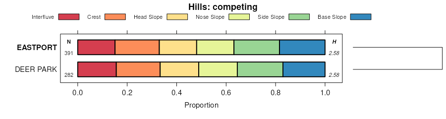
Official Series Description


Lab Data Summary

Aggregate lab data for the EASTPORT soil series. This aggregation is based on all pedons with a current taxon name of EASTPORT, and applied along 1-cm thick depth slices. Solid lines are the slice-wise median, bounded on either side by the interval defined by the slice-wise 5th and 95th percentiles. The median is the value that splits the data in half. Five percent of the data are less than the 5th percentile, and five percent of the data are greater than the 95th percentile. Values along the right hand side y-axis describe the proportion of pedon data that contribute to aggregate values at this depth. For example, a value of "90%" at 25cm means that 90% of the pedons correlated to EASTPORT were used in the calculation. Source: KSSL snapshot . Methods used to assemble the KSSL snapshot used by SoilWeb / SDE

There are insufficient data to create the lab data summary figure.


Water Balance

Monthly water balance estimated using a leaky-bucket style model for the EASTPORT soil series. Monthly precipitation (PPT) and potential evapotranspiration (PET) have been estimated from the 50th percentile of gridded values (PRISM 1981-2010) overlapping with the extent of SSURGO map units containing each series as a major component. Monthly PET values were estimated using the method of Thornthwaite (1948). These (and other) climatic parameters are calculated with each SSURGO refresh and provided by the fetchOSD function of the soilDB package. Representative water storage values (“AWC” in the figures) were derived from SSURGO by taking the 50th percentile of profile-total water storage (sum[awc_r * horizon thickness]) for each soil series. Note that this representation of “water storage” is based on the average ability of most plants to extract soil water between 15 bar (“permanent wilting point”) and 1/3 bar (“field capacity”) matric potential. Soil moisture state can be roughly interpreted as “dry” when storage is depleted, “moist” when storage is between 0mm and AWC, and “wet” when there is a surplus. Clearly there are a lot of assumptions baked into this kind of monthly water balance. This is still a work in progress.

Click the image to view it full size.


Click the image to view it full size.

Sibling Summary

Siblings are those soil series that occur together in map units, in this case with the EASTPORT series. Sketches are arranged according to their subgroup-level taxonomic structure. Source: SSURGO snapshot , parsed OSD records and snapshot of SC database .

Click the image to view it full size.

Select annual climate data summaries for the EASTPORT series and siblings. Series are sorted according to hierarchical clustering of median values. Source: SSURGO map unit geometry and 1981-2010, 800m PRISM data .

Click the image to view it full size.

Geomorphic description summaries for the EASTPORT series and siblings. Series are sorted according to hierarchical clustering of proportions and relative hydrologic position within an idealized landform (e.g. top to bottom). Most soil series (SSURGO components) are associated with a hillslope position and one or more landform-specific positions: hills, mountain slopes, terraces, and/or flats. Proportions can be interpreted as an aggregate representation of geomorphic membership. The values printed to the left (number of component records) and right (Shannon entropy) of stacked bars can be used to judge the reliability of trends. Small Shannon entropy values suggest relatively consistent geomorphic association, while larger values suggest lack thereof. Source: SSURGO component records .

Click the image to view it full size.

Click the image to view it full size.

There are insufficient data to create the 3D mountains figure.

Click the image to view it full size.

Click the image to view it full size.

Competing Series

Soil series competing with EASTPORT share the same family level classification in Soil Taxonomy. Source: parsed OSD records and snapshot of the SC database .

Click the image to view it full size.

Select annual climate data summaries for the EASTPORT series and competing. Series are sorted according to hierarchical clustering of median values. Source: SSURGO map unit geometry and 1981-2010, 800m PRISM data .

Click the image to view it full size.

Geomorphic description summaries for the EASTPORT series and competing. Series are sorted according to hierarchical clustering of proportions and relative hydrologic position within an idealized landform (e.g. top to bottom). Proportions can be interpreted as an aggregate representation of geomorphic membership. Most soil series (SSURGO components) are associated with a hillslope position and one or more landform-specific positions: hills, mountain slopes, terraces, and/or flats. The values printed to the left (number of component records) and right (Shannon entropy) of stacked bars can be used to judge the reliability of trends. Shannon entropy values close to 0 represent soil series with relatively consistent geomorphic association, while values close to 1 suggest lack thereof. Source: SSURGO component records .

Click the image to view it full size.

Click the image to view it full size.

There are insufficient data to create the 3D mountains figure.

There are insufficient data to create the 3D terrace figure.

Click the image to view it full size.

Soil series sharing subgroup-level classification with EASTPORT, arranged according to family differentiae. Hovering over a series name will print full classification and a small sketch from the OSD. Source: snapshot of SC database .

Block Diagrams

No block diagrams are available.

Map Units

Map units containing EASTPORT as a major component. Limited to 250 records.

Map Unit Name Symbol Map Unit Area (ac) Map Unit Key National Map Unit Symbol Soil Survey Area Publication Date Map Scale
Eastport sand, 0 to 6 percent slopes11B3931902426cyvmi00119931:20000
Eastport sand, 0 to 6 percent slopes11B1081912496f0bmi00719981:12000
Eastport-Rubicon sands, 0 to 6 percent slopesErB28291891516btnmi01119641:20000
Eastport-Rubicon-Roscommon association, undulatingEtB19151891596btxmi01119641:20000
Eastport-Rubicon association, rollingEsC11701891586btwmi01119641:20000
Eastport-Grattan sands, 6 to 12 percent slopesEgC87326734402qz4pmi01119641:20000
Eastport-Grattan sands, 0 to 6 percent slopesEgB41226734392qz4nmi01119641:20000
Eastport-Rubicon sands, 6 to 12 percent slopesErC3921891526btpmi01119641:20000
Adrian-Eastport-Rubicon association, undulatingAeB2921891076bs7mi01119641:20000
Eastport-Rubicon sands, 6 to 12 percent slopes, moderately erodedErC21211891536btqmi01119641:20000
Eastport-Grattan sands, 12 to 18 percent slopesEgD11426734422qz4rmi01119641:20000
Eastport-Grattan association, rollingEhC9626734452qz4vmi01119641:20000
Eastport-Grattan sands, 12 to 18 percent slopes, moderately erodedEgD25026734432qz4smi01119641:20000
Eastport-Rubicon sands, 12 to 18 percent slopesErD391891546btrmi01119641:20000
Eastport-Grattan sands, 25 to 45 percent slopesEgF3026734442qz4tmi01119641:20000
Eastport-Grattan sands, 6 to 12 percent slopes, moderately erodedEgC22726734412qz4qmi01119641:20000
Eastport-Rubicon sands, 18 to 25 percent slopes, moderately erodedErE2241891566bttmi01119641:20000
Eastport-Rubicon sands, 25 to 45 percent slopesErF221891576btvmi01119641:20000
Eastport-Rubicon sands, 12 to 18 percent slopes, moderately erodedErD271891556btsmi01119641:20000
Eastport-Grattan sands, 0 to 6 percent slopes123B2326735752qz4nmi01719781:20000
Eastport-Grattan sands, 12 to 18 percent slopes123D226735762qz4rmi01719781:20000
Eastport sand, 0 to 6 percent slopesEdB10271904256d4rmi02919701:15840
Eastport sand, 6 to 12 percent slopesEdC5121904266d4smi02919701:15840
Eastport sand, 0 to 6 percent slopes25B11241905556d8ymi03119881:15840
Eastport sand, 12 to 25 percent slopes25D2881905566d8zmi03119881:15840
Eastport-Roscommon sands, 0 to 6 percent slopesEeB338615880481q9hcmi04119691:24000
Eastport sand, 0 to 6 percent slopesEdB297015880471q9hbmi04119691:24000
Roscommon-Eastport sands, 0 to 6 percent slopesReB20281893666c1lmi04719681:20000
Eastport sand, 0 to 6 percent slopesEdB19881893306c0fmi04719681:20000
Lake beach and Eastport sand, 0 to 6 percent slopesLeB7001894986c5vmi05519631:15840
Eastport-Roscommon sands, 0 to 2 percent slopesErA3681894116c31mi05519631:15840
Eastport sand, 0 to 6 percent slopesEdB64341907916djkmi08919671:20000
Eastport-Leafriver complex, 0 to 35 percent slopes38E10503416398fz96mi09719941:20000
Eastport sand, 15 to 35 percent slopes17E4642416362fz81mi09719941:20000
Eastport sand, 0 to 15 percent slopes17D856416361fz80mi09719941:20000
Eastport sand, 1 to 8 percent slopes67B10091909316dp2mi14119891:15840
Eastport sand, 0 to 6 percent slopesEaB1930187413690lmi14719691:20000
Eastport sand, 6 to 18 percent slopesEaC435187414690mmi14719691:20000
Eastport, Arenac, and Kalkaska sands, 2 to 7 percent slopes, slightly erodedEaB133918824969wkmi15119551:15840
Eastport, Arenac, and Kalkaska sands, 0 to 2 percent slopes, slightly erodedEaA118118824869wjmi15119551:15840
Eastport fine sand and beach sand, 0 to 2 percent slopesEbA015418825169wmmi15119551:15840
Eastport fine sand and beach sand, 2 to 18 percent slopesEbC014418825269wnmi15119551:15840
Eastport, Arenac, and Kalkaska sands, 7 to 14 percent slopes, slightly erodedEaC110618825069wlmi15119551:15840
Eastport sand, 0 to 6 percent slopesEsB552508266690lmi15119551:15840

Map of Series Extent

Approximate geographic distribution of the EASTPORT soil series. To learn more about how this distribution was mapped, or to compare this soil series extent to others, use the Series Extent Explorer (SEE) application. Source: generalization of SSURGO geometry .