| Eapa loam, 2 to 8 percent slopes | 84C | 92002 | 343255 | 2tvln | mt011 | 1992 | 1:24000 |
Eapa loam, 0 to 2 percent slopes | 84A | 16352 | 343254 | 2v2ks | mt011 | 1992 | 1:24000 |
Eapa-Yamacall loams, 2 to 8 percent slopes | 167C | 8079 | 342946 | chvs | mt011 | 1992 | 1:24000 |
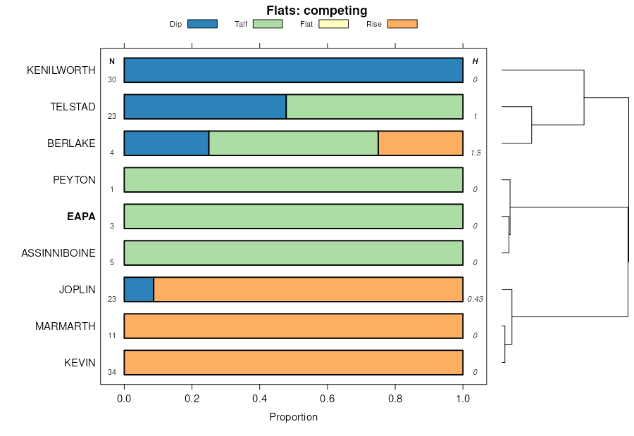
Eapa-Archin loams, 2 to 8 percent slopes | 184C | 7468 | 342988 | chx4 | mt011 | 1992 | 1:24000 |
Eapa loam, 8 to 15 percent slopes | 84D | 1973 | 343256 | cj5s | mt011 | 1992 | 1:24000 |
Eapa loam, warm, 1 to 6 percent slopes | 603C | 977 | 343162 | cj2r | mt011 | 1992 | 1:24000 |
Eapa loam, 2 to 8 percent slopes | 41C | 20821 | 343440 | 2tvln | mt017 | 1995 | 1:24000 |
Chinook-Twilight-Eapa complex, 2 to 8 percent slopes | 355C | 13563 | 343403 | cjbj | mt017 | 1995 | 1:24000 |
Eapa loam, 0 to 2 percent slopes | 41A | 5477 | 343439 | 2v2ks | mt017 | 1995 | 1:24000 |
Eapa loam, 0 to 4 percent slopes | 654B | 295 | 343614 | cjkb | mt017 | 1995 | 1:24000 |
Eapa-Delpoint loams, 2 to 8 percent slopes | 969C | 90 | 343820 | cjrz | mt017 | 1995 | 1:24000 |
Kremlin-Eapa loams, 0 to 4 percent slopes | 501B | 14044 | 754481 | tb33 | mt021 | 1971 | 1:24000 |
Eapa loam, 0 to 4 percent slopes | 30B | 1001 | 754476 | tb2y | mt021 | 1971 | 1:24000 |
Eapa loam, 2 to 8 percent slopes | 84C | 35487 | 342298 | 2tvln | mt025 | 1991 | 1:24000 |
Eapa-Yamacall loams, 2 to 8 percent slopes | 167C | 5096 | 342118 | ch02 | mt025 | 1991 | 1:24000 |
Eapa loam, 0 to 2 percent slopes | 84A | 4093 | 342297 | 2v2ks | mt025 | 1991 | 1:24000 |
Eapa loam, 8 to 15 percent slopes | 84D | 628 | 342299 | ch5x | mt025 | 1991 | 1:24000 |
Chinook-Twilight-Eapa complex, 2 to 8 percent slopes | 383C | 32667 | 342644 | chk1 | mt033 | 2002 | 1:24000 |
Eapa loam, 4 to 8 percent slopes | 48C | 23864 | 342657 | chkg | mt033 | 2002 | 1:24000 |
Eapa loam, 0 to 4 percent slopes | 48B | 22895 | 342656 | chkf | mt033 | 2002 | 1:24000 |
Eapa loam, 0 to 2 percent slopes | 481A | 337 | 342741 | 2v2ks | mt033 | 2002 | 1:24000 |
Eapa loam, 2 to 8 percent slopes | 481C | 72 | 339734 | 2tvln | mt033 | 2002 | 1:24000 |
Eapa-Gerdrum complex, 2 to 8 percent slopes | 62 | 4724 | 344427 | ckdk | mt055 | 1981 | 1:24000 |
Eapa loam, 2 to 8 percent slopes | 61 | 2537 | 344426 | 2tvln | mt055 | 1981 | 1:24000 |
Eapa loam, 0 to 2 percent slopes | 60 | 1796 | 344425 | 2v2ks | mt055 | 1981 | 1:24000 |
Eapa loam, 2 to 8 percent slopes | 52B | 7655 | 344596 | cgkh | mt065 | 1996 | 1:24000 |
Eapa-Attewan loams, 0 to 2 percent slopes | 152A | 3124 | 344485 | cghw | mt065 | 1996 | 1:24000 |
Eapa loam, 0 to 2 percent slopes | 52A | 1607 | 344595 | cgkg | mt065 | 1996 | 1:24000 |
Evanston loam, 2 to 6 percent slopes | 51 | 1280 | 344940 | cky3 | mt079 | 1986 | 1:24000 |
Evanston-Delpoint loams, 2 to 8 percent slopes | 52 | 1202 | 344941 | cky4 | mt079 | 1986 | 1:24000 |
Evanston loam, 0 to 2 percent slopes | 50 | 804 | 344937 | cky0 | mt079 | 1986 | 1:24000 |
Kremlin-Eapa loams, 0 to 4 percent slopes | 146 | 319 | 1145695 | 17g5x | mt079 | 1986 | 1:24000 |
Kremlin-Eapa loams, 0 to 4 percent slopes | 501B | 1158 | 1711692 | 1vg4w | mt083 | 1973 | 1:24000 |
Eapa loam, 0 to 4 percent slopes | 30B | 298 | 1677535 | 1t9m1 | mt109 | 1956 | 1:31680 |
Eapa loam, calcareous, 0 to 8 percent slopes | 152B | 118 | 2396643 | cghx | mt111 | 1966 | 1:20000 |
Eapa loam, 4 to 8 percent slopes | 830C | 4519 | 2434245 | 2mq11 | mt624 | 2021 | 1:24000 |
Eapa loam, 0 to 4 percent slopes | 830B | 2351 | 2434242 | 2mq0y | mt624 | 2021 | 1:24000 |
Eapa-Attewan loams, 0 to 2 percent slopes | 152A | 1428 | 2513996 | cghw | mt624 | 2021 | 1:24000 |
Eapa loam, calcareous surface, 0 to 8 percent slopes | 816C | 840 | 1949510 | 23fmf | mt624 | 2021 | 1:24000 |
Eapa loam, 8 to 15 percent slopes | 830D | 481 | 2610251 | 2r8d0 | mt624 | 2021 | 1:24000 |
Eapa loam, 0 to 2 percent slopes | 52A | 63 | 2513978 | cgkg | mt624 | 2021 | 1:24000 |
Eapa loam, 2 to 8 percent slopes | 52B | 53 | 2513979 | cgkh | mt624 | 2021 | 1:24000 |
Eapa loam, 2 to 8 percent slopes | 52B | 586 | 1712548 | 1vh1h | mt655 | 1975 | 1:24000 |
Eapa loam, calcareous, 0 to 8 percent slopes | 152B | 209 | 1712538 | 1vh15 | mt655 | 1975 | 1:24000 |
Eapa loam, 2 to 8 percent slopes | 52B | 8299 | 341697 | cgkh | mt666 | 2008 | 1:24000 |
Eapa-Attewan loams, 0 to 2 percent slopes | 152A | 2146 | 341647 | cghw | mt666 | 2008 | 1:24000 |
Eapa loam, 0 to 2 percent slopes | 52A | 2053 | 341696 | cgkg | mt666 | 2008 | 1:24000 |
Eapa-Attewan loams, 0 to 2 percent slopes, fan | 352A | 1852 | 1711527 | 1vfzk | mt666 | 2008 | 1:24000 |
Eapa loam, calcareous, 0 to 8 percent slopes | 152B | 351 | 341648 | cghx | mt666 | 2008 | 1:24000 |
Marmarth-Eapa loams, 0 to 6 percent slopes | L2819B | 141 | 2563482 | 2qxl0 | nd011 | 1969 | 1:20000 |
Marmarth-Eapa loams, 0 to 6 percent slopes | L2819B | 18 | 2715921 | 2qxl0 | nd087 | 1974 | 1:20000 |
Eapa-Archin complex, 0 to 3 percent slopes | EcA | 6879 | 355738 | 2zj50 | sd063 | 1984 | 1:24000 |
Eapa loam, 0 to 3 percent slopes | EaA | 4684 | 355737 | 2zj4z | sd063 | 1984 | 1:24000 |
Eapa-Grail complex, 2 to 6 percent slopes | EgB | 30729 | 355436 | cxvp | sd601 | 1983 | 1:24000 |
Eapa loam, 2 to 6 percent slopes | EaB | 21378 | 355432 | cxvk | sd601 | 1983 | 1:24000 |
Eapa-Delridge loams, 2 to 6 percent slopes | EdB | 19979 | 355434 | cxvm | sd601 | 1983 | 1:24000 |
Eapa-Grail complex, 6 to 9 percent slopes | EgC | 14776 | 355437 | cxvq | sd601 | 1983 | 1:24000 |
Eapa-Delridge loams, 6 to 9 percent slopes | EdC | 12058 | 355435 | cxvn | sd601 | 1983 | 1:24000 |
Eapa loam, 0 to 2 percent slopes | EaA | 3313 | 355431 | cxvj | sd601 | 1983 | 1:24000 |
Eapa loam, 6 to 9 percent slopes | EaC | 2183 | 355433 | cxvl | sd601 | 1983 | 1:24000 |
Eapa-Scobey complex, 2 to 12 percent slopes | 776 | 4095 | 3410526 | 31v1h | wy630 | | 1:24000 |
Ethridge-Eapa-Savar complex, 0 to 8 percent slopes | 769 | 775 | 3410519 | 31gbc | wy630 | | 1:24000 |