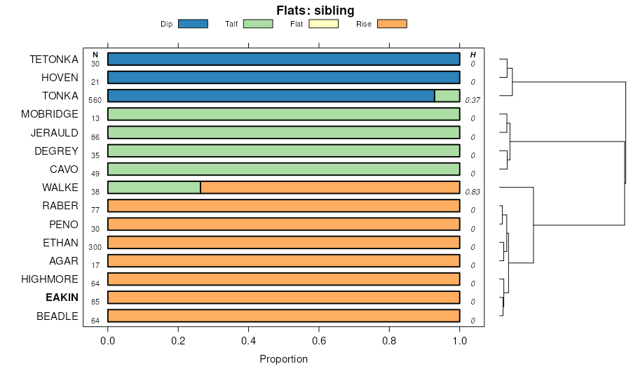
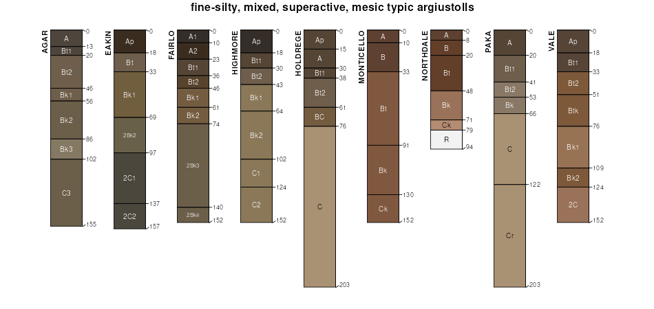
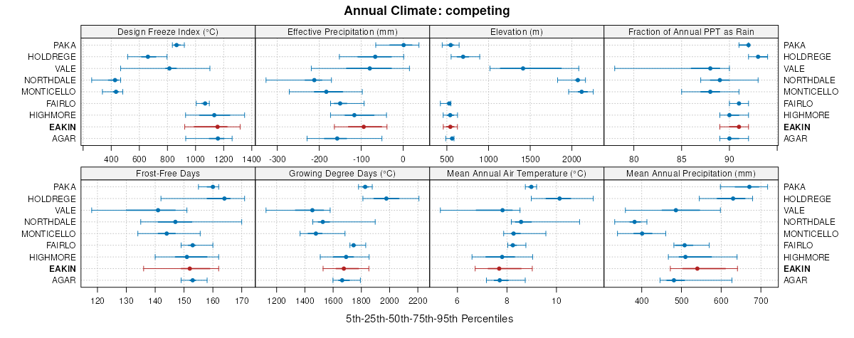
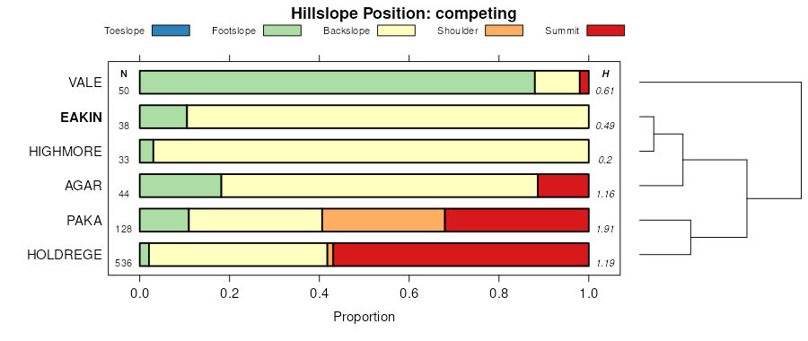
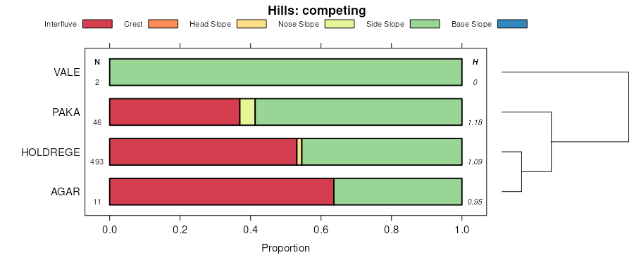
| Eakin-Ethan complex, 2 to 6 percent slopes | EeB | 9528 | 354847 | 2xhbv | sd003 | 1979 | 1:20000 |
Eakin-DeGrey silt loams, 0 to 2 percent slopes | EdA | 5797 | 354846 | 2wkq7 | sd003 | 1979 | 1:20000 |
Eakin-Ethan complex, 2 to 6 percent slopes | EeB | 85672 | 355020 | 2xhbv | sd023 | 1980 | 1:20000 |
Eakin-Ethan complex, 6 to 9 percent slopes | EeC | 44276 | 355021 | 2xhc0 | sd023 | 1980 | 1:20000 |
Eakin-DeGrey silt loams, 0 to 4 percent slopes | EdA | 22497 | 355019 | 2xhd5 | sd023 | 1980 | 1:20000 |
Eakin silt loam, 0 to 2 percent slopes | EaA | 11160 | 355017 | 2yyhy | sd023 | 1980 | 1:20000 |
Eakin-Beadle complex, 2 to 6 percent slopes | EbB | 6862 | 355018 | 2yyg5 | sd023 | 1980 | 1:20000 |
Beadle-Eakin complex, 6 to 9 percent slopes | BbC | 2679 | 355003 | 2yyg8 | sd023 | 1980 | 1:20000 |
Eakin-Ethan complex, 2 to 6 percent slopes | EaB | 52543 | 354893 | 2xhbv | sd043 | 1979 | 1:20000 |
Eakin-Ethan complex, 0 to 3 percent slopes | EaA | 8232 | 354892 | 2yyhz | sd043 | 1979 | 1:20000 |
Eakin-Ethan complex, 6 to 9 percent slopes | EaC | 6929 | 354894 | 2xhc0 | sd043 | 1979 | 1:20000 |
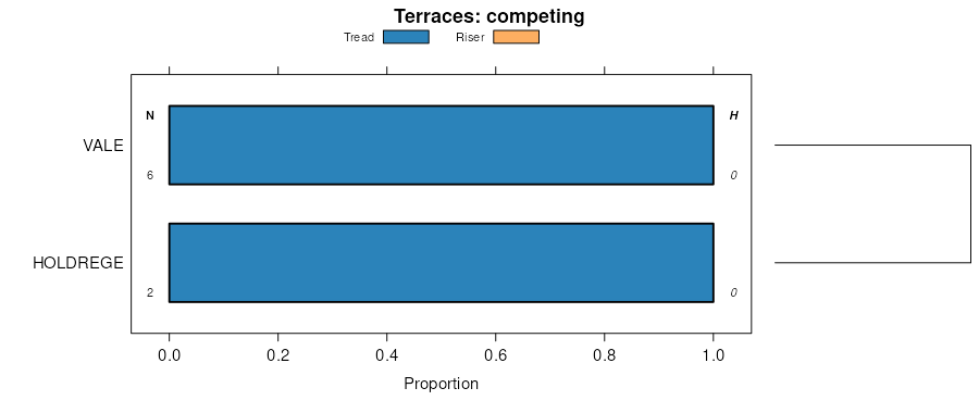
Eakin-Raber complex, 2 to 6 percent slopes | ReB | 63438 | 352669 | 2wbpz | sd059 | 1959 | 1:20000 |
Raber-Eakin complex, 6 to 9 percent slopes | RaC | 8837 | 352665 | 2wbq0 | sd059 | 1959 | 1:20000 |
Eakin-Raber complex, 0 to 2 percent slopes | RaA | 3324 | 352663 | 2wbpy | sd059 | 1959 | 1:20000 |
Eakin-Jerauld silt loams, 2 to 6 percent slopes | EmB | 2276 | 352597 | 2yyhs | sd059 | 1959 | 1:20000 |
Eakin-DeGrey silt loams, 0 to 2 percent slopes | EcA | 2030 | 352594 | 2wkq7 | sd059 | 1959 | 1:20000 |
Eakin-DeGrey silt loams, 2 to 6 percent slopes | EcB | 1969 | 352595 | 2yyhp | sd059 | 1959 | 1:20000 |
Eakin-Jerauld silt loams, 0 to 2 percent slopes | EmA | 904 | 352596 | 2yyhr | sd059 | 1959 | 1:20000 |
Glenham-Eakin complex, undulating | WrA | 382 | 352695 | cv08 | sd059 | 1959 | 1:20000 |
Jerauld-Eakin silt loams, 0 to 2 percent slopes | MeA | 326 | 352647 | 2yyht | sd059 | 1959 | 1:20000 |
Eakin-Raber complex, 2 to 6 percent slopes | ErB | 11627 | 353279 | 2wbpz | sd065 | 1970 | 1:20000 |
Raber-Eakin complex, 6 to 9 percent slopes | ErC | 5575 | 353280 | 2wbq0 | sd065 | 1970 | 1:20000 |
Eakin-Raber complex, 0 to 2 percent slopes | ErA | 2451 | 353278 | 2wbpy | sd065 | 1970 | 1:20000 |
Agar-Eakin silt loams, 2 to 6 percent slopes | AkB | 1126 | 353262 | 2xhbq | sd065 | 1970 | 1:20000 |
Eakin-Raber complex, 2 to 6 percent slopes | ErB | 31865 | 353795 | 2wbpz | sd069 | 1992 | 1:20000 |
Eakin-Peno complex, 6 to 9 percent slopes | EpC | 9162 | 353793 | 2xhc1 | sd069 | 1992 | 1:20000 |
Eakin-Raber complex, 0 to 2 percent slopes | ErA | 6395 | 353794 | 2wbpy | sd069 | 1992 | 1:20000 |
Eakin-Ethan-Onita complex, 2 to 6 percent slopes | EaB | 11233 | 356427 | 2yyj0 | sd073 | 1987 | 1:20000 |
Eakin-Raber complex, 2 to 6 percent slopes | ErB | 11 | 3333711 | 2wbpz | sd073 | 1987 | 1:20000 |
Eakin-Peno complex, 2 to 6 percent slopes | EpB | 29418 | 355324 | 2yyhv | sd107 | 1983 | 1:20000 |
Eakin-Raber complex, 0 to 2 percent slopes | EaA | 18569 | 355323 | 2wbpy | sd107 | 1983 | 1:20000 |
Eakin-Raber complex, 2 to 6 percent slopes | RaB | 10131 | 355363 | 2wbpz | sd107 | 1983 | 1:20000 |
Eakin-Peno complex, 6 to 9 percent slopes | EpC | 3551 | 355325 | 30t2j | sd107 | 1983 | 1:20000 |
Eakin-Raber complex, 2 to 6 percent slopes | RgB | 32610 | 353118 | 2wbpz | sd119 | 1967 | 1:20000 |
Eakin-Raber complex, 0 to 2 percent slopes | RhA | 26378 | 353120 | 2wbpy | sd119 | 1967 | 1:20000 |
Agar-Eakin silt loams, 0 to 2 percent slopes | AeA | 7465 | 353062 | 2yyhw | sd119 | 1967 | 1:20000 |
Agar-Eakin silt loams, 2 to 6 percent slopes | AeB | 4964 | 353063 | 2xhbq | sd119 | 1967 | 1:20000 |
Raber-Eakin complex, 6 to 9 percent slopes | RgC | 3270 | 353119 | 2wbq0 | sd119 | 1967 | 1:20000 |
Agar-Eakin silt loams, 5 to 9 percent slopes | AeC | 2349 | 353064 | 2yyhx | sd119 | 1967 | 1:20000 |
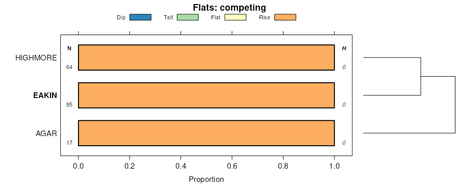
Highmore-Eakin silt loams, cool, 2 to 6 percent slopes | C721B | 27764 | 2800135 | 2rrrr | sd129 | 1975 | 1:20000 |
Highmore-Eakin silt loams, cool, 0 to 2 percent slopes | C721A | 4430 | 2800134 | 2rrrq | sd129 | 1975 | 1:20000 |
Highmore-Eakin silt loams, cool, 6 to 9 percent slopes | C721C | 3780 | 2800136 | 2rrrs | sd129 | 1975 | 1:20000 |
Raber-Eakin complex, 6 to 9 percent slopes | HmC | 3711 | 354499 | 2wbq0 | sd129 | 1975 | 1:20000 |
Eakin-Raber complex, 2 to 6 percent slopes | HmB | 2286 | 354498 | 2wbpz | sd129 | 1975 | 1:20000 |
Eakin-DeGrey silt loams, 0 to 2 percent slopes | EaA | 75707 | 355497 | 2wkq7 | sd603 | 1983 | 1:20000 |
DeGrey-Eakin-Jerauld silt loams, 0 to 2 percent slopes | DaA | 6688 | 355493 | 2yyhq | sd603 | 1983 | 1:20000 |
Eakin-Beadle complex, 2 to 6 percent slopes | BeB | 5127 | 355482 | 2yyg5 | sd603 | 1983 | 1:20000 |
Beadle-Eakin complex, 6 to 9 percent slopes | BeC | 1273 | 355483 | 2yyg8 | sd603 | 1983 | 1:20000 |
Eakin-Raber complex, 2 to 6 percent slopes | ErB | 1204 | 3333693 | 2wbpz | sd603 | 1983 | 1:20000 |