| Dunbarton silt loam, 14 to 18 percent slopes | 319E | 100 | 447094 | h07d | ia107 | 1998 | 1:12000 |
Dunbarton silt loam, deep variant, 9 to 14 percent slopes, moderately eroded | 326D2 | 374 | 409189 | fqsn | ia121 | 1968 | 1:15840 |
Dunbarton silt loam, 12 to 20 percent slopes, eroded | 505E2 | 15 | 199855 | 6pyy | il007 | 2006 | 1:12000 |
Dunbarton silt loam, 6 to 12 percent slopes, eroded | 505D2 | 8 | 1482769 | 1lry8 | il007 | 2006 | 1:12000 |
Dunbarton silty clay loam, 12 to 20 percent slopes, severely eroded | 505E3 | 589 | 1478075 | 1lm1v | il015 | 2005 | 1:12000 |
Dunbarton silt loam, 12 to 20 percent slopes, eroded | 505E2 | 393 | 1478072 | 1lm1r | il015 | 2005 | 1:12000 |
Dunbarton silt loam, 6 to 12 percent slopes, eroded | 505D2 | 364 | 1385794 | 1hj11 | il015 | 2005 | 1:12000 |
Dunbarton silty clay loam, 6 to 12 percent slopes, severely eroded | 505D3 | 343 | 1385795 | 1hj12 | il015 | 2005 | 1:12000 |
Dunbarton silt loam, 20 to 35 percent slopes, eroded | 505F2 | 263 | 1385797 | 1hj14 | il015 | 2005 | 1:12000 |
Dunbarton silt loam, 35 to 60 percent slopes | 505G | 206 | 1385798 | 1hj15 | il015 | 2005 | 1:12000 |
Dunbarton silt loam, 35 to 60 percent slopes | 505G | 6 | 2604078 | 2r77q | il067 | 1993 | 1:15840 |
Dunbarton silt loam, 18 to 60 percent slopes | 505G | 206 | 1480517 | 1lplm | il071 | 2005 | 1:12000 |
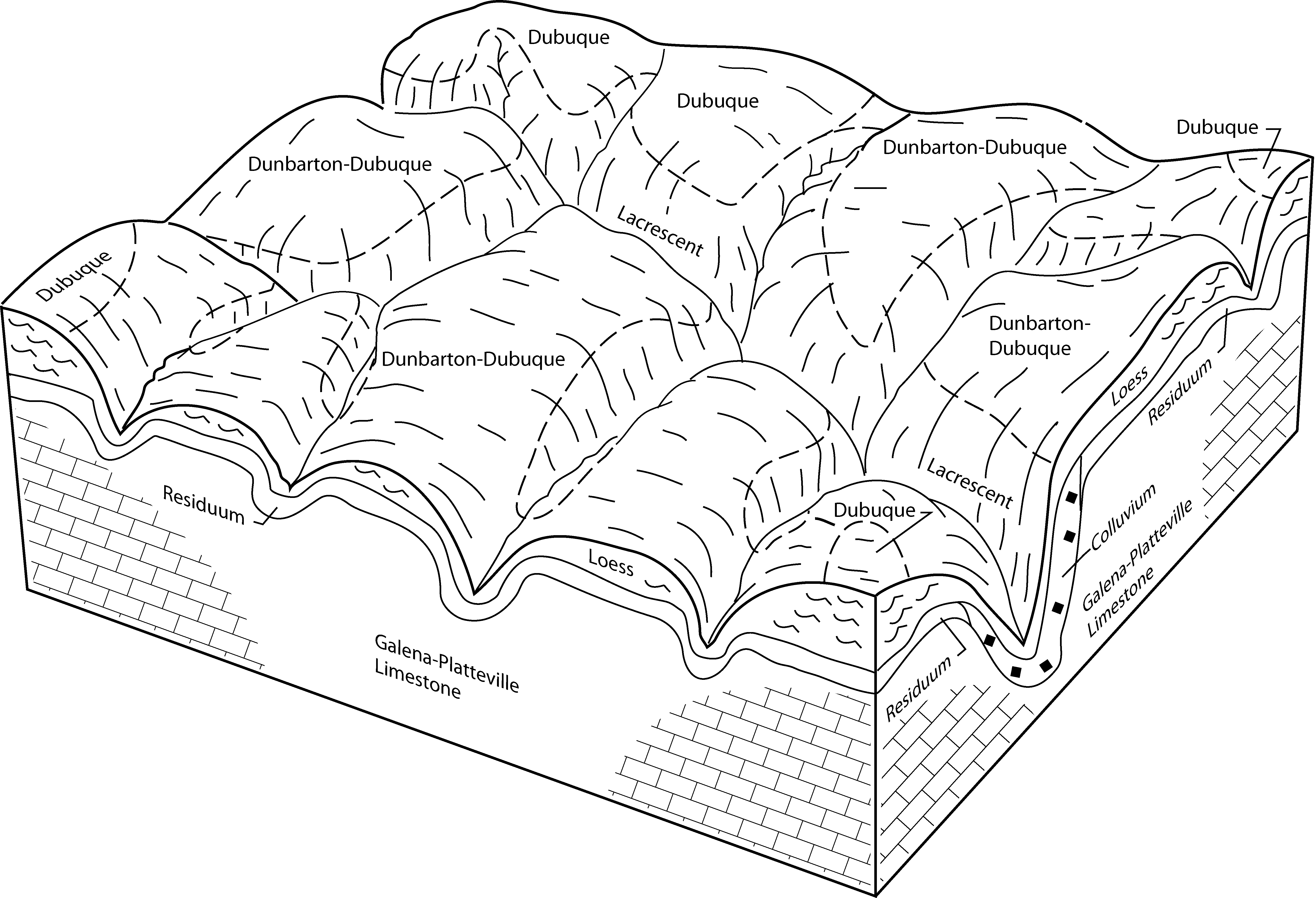
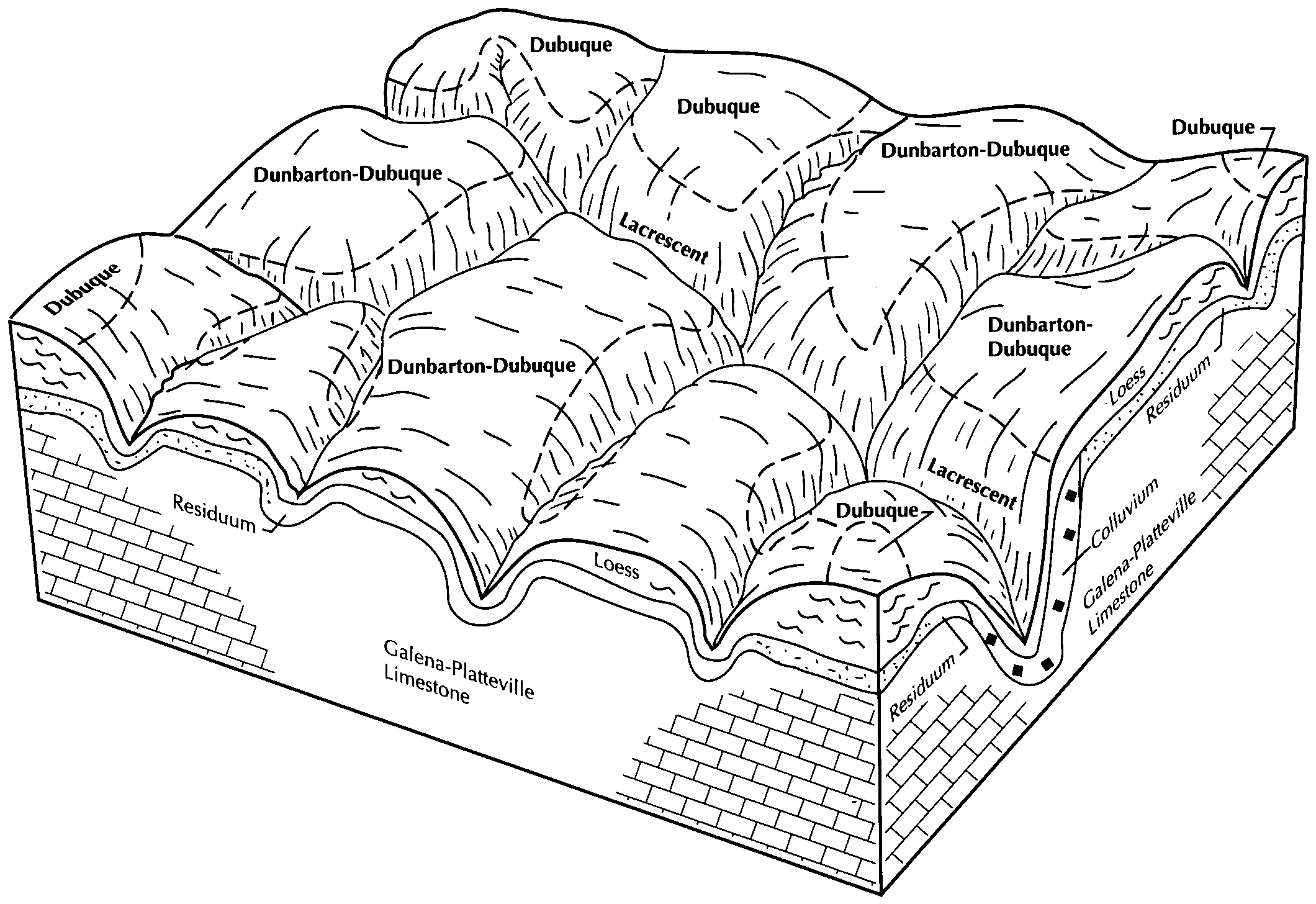
Dunbarton-Dubuque silt loams, 15 to 25 percent slopes, moderately eroded | 873E2 | 12669 | 1949603 | 2t7z9 | il085 | 1990 | 1:12000 |
Dunbarton-Dubuque silt loams, 7 to 15 percent slopes, moderately eroded | 873D2 | 11436 | 1949602 | 2t7z8 | il085 | 1990 | 1:12000 |
Dunbarton silt loam, 6 to 12 percent slopes, eroded | 505D2 | 309 | 1398947 | 1hyqb | il141 | 2005 | 1:12000 |
Dunbarton silt loam, 12 to 20 percent slopes, eroded | 505E2 | 264 | 1478844 | 1lmvn | il141 | 2005 | 1:12000 |
Dunbarton silt loam, 18 to 60 percent slopes | 505G | 520 | 244894 | 86tt | il187 | 2002 | 1:12000 |
Dunbarton silt loam, 6 to 12 percent slopes, eroded | 505D2 | 1348 | 174113 | 5v5k | il201 | 1997 | 1:12000 |
Dunbarton silt loam, 4 to 6 percent slopes, eroded | 505C2 | 771 | 174112 | 5v5j | il201 | 1997 | 1:12000 |
Dunbarton silt loam, 12 to 20 percent slopes, eroded | 505E2 | 272 | 174114 | 5v5l | il201 | 1997 | 1:12000 |
Dunbarton silt loam, rocky, 4 to 12 percent slopes | 95C | 1177 | 429102 | gdj0 | mn169 | 1987 | 1:20000 |
Lacrescent-Dunbarton complex, very stony, 30 to 60 percent slopes | 1130F | 5908 | 2495357 | 2lk96 | wi023 | 1960 | 1:12000 |
Newglarus-Dunbarton silt loams, 12 to 20 percent slopes, moderately eroded | 1180D2 | 10537 | 2629035 | 2t7yz | wi025 | 1972 | 1:15840 |
Newglarus-Dunbarton silt loams, 6 to 12 percent slopes, moderately eroded | 1180C2 | 8977 | 2629037 | 2t7yy | wi025 | 1972 | 1:15840 |
Newglarus-Dunbarton, very stony, silt loams, 20 to 30 percent slopes, very rocky | 1180E | 1499 | 2629039 | 2t7z0 | wi025 | 1972 | 1:15840 |
Lacrescent-Dunbarton complex, very stony, 30 to 60 percent slopes | 1130F | 1149 | 2809841 | 2lk96 | wi025 | 1972 | 1:15840 |
Newglarus-Dunbarton silt loams, 2 to 6 percent slopes, moderately eroded | 1180B2 | 880 | 2629036 | 2t7yx | wi025 | 1972 | 1:15840 |
Newglarus-Dunbarton, very stony, silt loams, 30 to 60 percent slopes, very rocky | 1180F | 91 | 2629038 | 2t7z1 | wi025 | 1972 | 1:15840 |
Lacrescent-Dunbarton complex, very stony, 30 to 60 percent slopes | 1130F | 40553 | 2809831 | 2lk96 | wi043 | 1959 | 1:20000 |
Newglarus-Dunbarton, very stony, silt loams, 20 to 30 percent slopes, very rocky | 1180E | 4962 | 424210 | 2t7z0 | wi043 | 1959 | 1:20000 |
Newglarus-Dunbarton silt loams, 12 to 20 percent slopes, moderately eroded | 1180D2 | 2749 | 424208 | 2t7yz | wi043 | 1959 | 1:20000 |
Newglarus-Dunbarton, very stony, silt loams, 30 to 60 percent slopes, very rocky | 1180F | 173 | 424211 | 2t7z1 | wi043 | 1959 | 1:20000 |
Newglarus-Dunbarton silt loams, 6 to 12 percent slopes, moderately eroded | 1180C2 | 108 | 424207 | 2t7yy | wi043 | 1959 | 1:20000 |
Newglarus-Dunbarton silt loams, 12 to 20 percent slopes, moderately eroded | 1180D2 | 9576 | 2629032 | 2t7yz | wi045 | 1969 | 1:12000 |
Newglarus-Dunbarton silt loams, 6 to 12 percent slopes, moderately eroded | 1180C2 | 8910 | 2629031 | 2t7yy | wi045 | 1969 | 1:12000 |
Lacrescent-Dunbarton complex, very stony, 30 to 60 percent slopes | 1130F | 2575 | 2809847 | 2lk96 | wi045 | 1969 | 1:12000 |
Newglarus-Dunbarton, very stony, silt loams, 20 to 30 percent slopes, very rocky | 1180E | 1115 | 2629033 | 2t7z0 | wi045 | 1969 | 1:12000 |
Newglarus-Dunbarton silt loams, 2 to 6 percent slopes, moderately eroded | 1180B2 | 844 | 2629030 | 2t7yx | wi045 | 1969 | 1:12000 |
Newglarus-Dunbarton, very stony, silt loams, 30 to 60 percent slopes, very rocky | 1180F | 109 | 2629034 | 2t7z1 | wi045 | 1969 | 1:12000 |
Lacrescent-Dunbarton complex, very stony, 30 to 60 percent slopes | 1130F | 12746 | 2561807 | 2lk96 | wi049 | 1960 | 1:20000 |
Newglarus-Dunbarton, very stony, silt loams, 20 to 30 percent slopes, very rocky | 1180E | 2260 | 424587 | 2t7z0 | wi049 | 1960 | 1:20000 |
Newglarus-Dunbarton silt loams, 12 to 20 percent slopes, moderately eroded | 1180D2 | 2002 | 424585 | 2t7yz | wi049 | 1960 | 1:20000 |
Newglarus-Dunbarton, very stony, silt loams, 30 to 60 percent slopes, very rocky | 1180F | 335 | 2806662 | 2t7z1 | wi049 | 1960 | 1:20000 |
Newglarus-Dunbarton silt loams, 6 to 12 percent slopes, moderately eroded | 1180C2 | 277 | 424583 | 2t7yy | wi049 | 1960 | 1:20000 |
Lacrescent-Dunbarton complex, very stony, 30 to 60 percent slopes | 1130F | 2416 | 2561808 | 2lk96 | wi065 | 1964 | 1:15840 |
Newglarus-Dunbarton silt loams, 12 to 20 percent slopes, moderately eroded | 1180D2 | 2346 | 2561802 | 2t7yz | wi065 | 1964 | 1:15840 |
Newglarus-Dunbarton, very stony, silt loams, 30 to 60 percent slopes, very rocky | 1180F | 2283 | 2561805 | 2t7z1 | wi065 | 1964 | 1:15840 |
Newglarus-Dunbarton, very stony, silt loams, 20 to 30 percent slopes, very rocky | 1180E | 1945 | 2561806 | 2t7z0 | wi065 | 1964 | 1:15840 |
Newglarus-Dunbarton silt loams, 6 to 12 percent slopes, moderately eroded | 1180C2 | 812 | 2561804 | 2t7yy | wi065 | 1964 | 1:15840 |
Lacrescent-Dunbarton complex, 20 to 30 percent slopes, very stony | 1130E | 669 | 2809837 | 2sb85 | wi065 | 1964 | 1:15840 |
Newglarus-Dunbarton silt loams, 2 to 6 percent slopes, moderately eroded | 1180B2 | 59 | 2561803 | 2t7yx | wi065 | 1964 | 1:15840 |
Lacrescent-Dunbarton complex, very stony, 30 to 60 percent slopes | 1130F | 761 | 2495358 | 2lk96 | wi123 | 1965 | 1:12000 |


