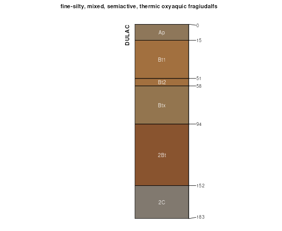
| Dulac silt loam, 0 to 2 percent slopes | DuA | 3916 | 329658 | c214 | al063 | 2013 | 1: |
Cuthbert, Dulac, and Ruston soils, 12 to 35 percent slopes (sweatman, providence and smithdale) | CrE | 93720 | 331831 | c497 | ms013 | 1963 | 1:15840 |
Cuthbert, Dulac, and Ruston soils, 12 to 35 percent slopes. severely eroded (sweatman, providence and smithdale) | CrE3 | 24538 | 331832 | c498 | ms013 | 1963 | 1:15840 |
Dulac silt loam, 5 to 8 percent slopes, severely eroded | DuC3 | 15781 | 331836 | 2w6fr | ms013 | 1963 | 1:15840 |
Dulac silt loam, 8 to 12 percent slopes, severely eroded | DuD3 | 7359 | 331838 | c49g | ms013 | 1963 | 1:15840 |
Cuthbert-Dulac and Ruston soils, 8 to 12 percent slopes, severely eroded (sweatman, providence and smithdale) | CrD3 | 5026 | 331830 | c496 | ms013 | 1963 | 1:15840 |
Dulac silt loam, 5 to 8 percent slopes, eroded | DuC2 | 4772 | 331835 | c49c | ms013 | 1963 | 1:15840 |
Dulac silt loam, 8 to 12 percent slopes, eroded | DuD2 | 2116 | 331837 | c49f | ms013 | 1963 | 1:15840 |
Cuthbert, Dulac, and Ruston soils, 8 to 12 percent slopes (sweatman, providence and smithdale) | CrD | 1643 | 331829 | c495 | ms013 | 1963 | 1:15840 |
Dulac silt loam, 2 to 5 percent slopes, severely eroded | DuB3 | 1051 | 331834 | 2w6fq | ms013 | 1963 | 1:15840 |
Dulac silt loam, 2 to 5 percent slopes, moderately eroded | DuB2 | 736 | 331833 | 2w6fp | ms013 | 1963 | 1:15840 |
Dulac silt loam, 8 to 12 percent slopes, severely eroded | 3D3 | 1506 | 567545 | m1kx | ms015 | 1985 | 1:20000 |
Dulac silt loam, 5 to 8 percent slopes, severely eroded | 3C3 | 826 | 567544 | m1kw | ms015 | 1985 | 1:20000 |
Dulac silt loam, 5 to 8 percent slopes, severely eroded | DuC3 | 3510 | 567846 | m1wm | ms043 | 1965 | 1:15840 |
Dulac silt loam, 5 to 8 percent slopes, eroded | DuC2 | 1144 | 567845 | m1wl | ms043 | 1965 | 1:15840 |
Dulac silt loam, 2 to 5 percent slopes, eroded | DuB2 | 75 | 567844 | m1wk | ms043 | 1965 | 1:15840 |
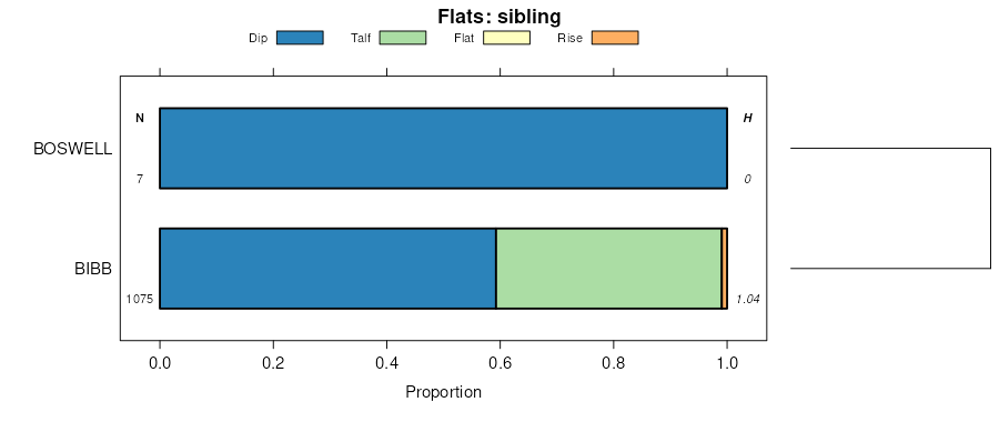
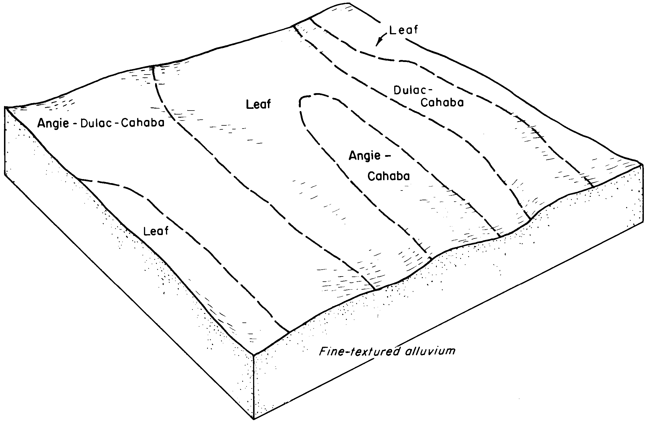
Dulac and Boswell soils, 5 to 8 percent slopes, eroded (kolin and lorman) | DbC2 | 4800 | 568151 | m26g | ms085 | 1961 | 1:20000 |
Dulac and Boswell soils, 5 to 8 percent slopes (kolin and lorman) | DbC | 1612 | 568150 | m26f | ms085 | 1961 | 1:20000 |
Dulac and Boswell soils, 2 to 5 percent slopes, eroded (kolin and lorman) | DbB2 | 1528 | 568149 | m26d | ms085 | 1961 | 1:20000 |
Dulac and Boswell soils, 5 to 8 percent slopes, severely eroded (kolin and lorman) | DbC3 | 642 | 568152 | m26h | ms085 | 1961 | 1:20000 |
Dulac and Boswell soils, 2 to 5 percent slopes (kolin and lorman) | DbB | 521 | 568148 | m26c | ms085 | 1961 | 1:20000 |
Dulac silt loam, 2 to 5 percent slopes, moderately eroded | DuB2 | 1760 | 333801 | 2w6fp | ms117 | 1995 | 1:24000 |
Dulac-Wilcox complex, 8 to 12 percent slopes, severely eroded | DwD3 | 9536 | 334184 | c6r4 | ms139 | 1963 | 1:15840 |
Dulac silt loam, 5 to 8 percent slopes, severely eroded | DuC3 | 6580 | 334182 | 2w6fr | ms139 | 1963 | 1:15840 |
Dulac silt loam, 2 to 5 percent slopes, severely eroded | DuB3 | 3096 | 334181 | 2w6fq | ms139 | 1963 | 1:15840 |
Dulac-Wilcox complex, 8 to 12 percent slopes | DwD | 2465 | 334183 | c6r3 | ms139 | 1963 | 1:15840 |
Dulac silt loam, 2 to 5 percent slopes, moderately eroded | DuB2 | 1586 | 334180 | 2w6fp | ms139 | 1963 | 1:15840 |
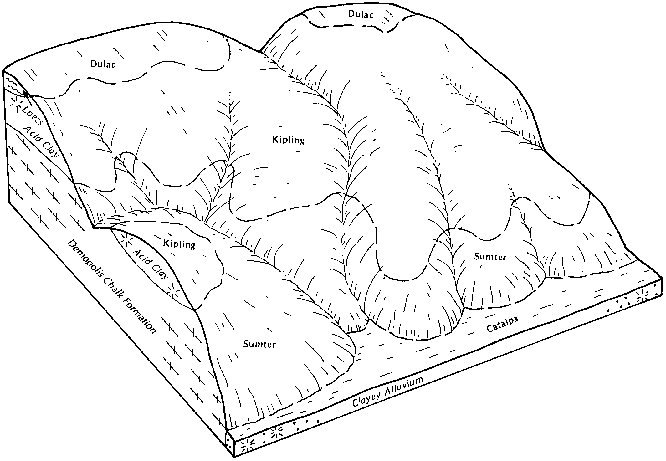
Dulac-Tippah complex, 5 to 8 percent slopes, eroded | DtC2 | 11748 | 2545335 | 2qsft | tn005 | 2011 | 1:12000 |
Dulac-Tippah complex, 8 to 12 percent slopes, eroded | DtD2 | 6857 | 2545337 | 2qsfw | tn005 | 2011 | 1:12000 |
Dulac-Tippah complex, 8 to 12 percent slopes, severely eroded | DtD3 | 3141 | 2545338 | 2qsfx | tn005 | 2011 | 1:12000 |
Dulac-Tippah complex, 2 to 5 percent slopes, eroded | DtB2 | 2895 | 2545333 | 2qsfr | tn005 | 2011 | 1:12000 |
Dulac-Tippah complex, 5 to 8 percent slopes, severely eroded | DtC3 | 607 | 2545336 | 2qsfv | tn005 | 2011 | 1:12000 |
Dulac-Tippah complex, 2 to 5 percent slopes, severely eroded | DtB3 | 32 | 2545334 | 2qsfs | tn005 | 2011 | 1:12000 |
Dulac silty clay loam, 5 to 8 percent slopes, severely eroded | DuC3 | 2207 | 327209 | bzh4 | tn023 | 1989 | 1:24000 |
Dulac silty clay loam, 2 to 5 percent slopes, severely eroded | DuB3 | 1651 | 327207 | bzh2 | tn023 | 1989 | 1:24000 |
Dulac silty clay loam, 8 to 12 percent slopes, severely eroded | DuD3 | 1159 | 327210 | bzh5 | tn023 | 1989 | 1:24000 |
Dulac silt loam, 5 to 8 percent slopes | DuC | 542 | 327208 | bzh3 | tn023 | 1989 | 1:24000 |
DULAC SILT LOAM, ERODED UNDULATING PHASE | Do | 2824 | 327292 | bzkt | tn039 | 2008 | 1:24000 |
DULAC SILT LOAM, UNDULATING PHASE | Ds | 1315 | 327295 | bzkx | tn039 | 2008 | 1:24000 |
DULAC SILT LOAM, ERODED ROLLING PHASE | Dn | 1116 | 327291 | bzks | tn039 | 2008 | 1:24000 |
DULAC SILTY CLAY LOAM, SEVERELY ERODED ROLLING PHASE | Dt | 993 | 327296 | bzky | tn039 | 2008 | 1:24000 |
DULAC SILT LOAM, ROLLING PHASE | Dp | 860 | 327293 | bzkv | tn039 | 2008 | 1:24000 |
DULAC SLIGHTLY ERODED UNDULATING PHASE | Dr | 679 | 327294 | bzkw | tn039 | 2008 | 1:24000 |
ROUGH GULLIED LAND, TIPPAH, AND DULAC SOILS | Rh | 159 | 327350 | bzmp | tn039 | 2008 | 1:24000 |
Dulac silt loam, 2 to 5 percent slopes | DkB | 1576 | 327551 | bzv5 | tn071 | 1961 | 1:15840 |
Dulac silt loam, 2 to 5 percent slopes, moderately eroded | DkB2 | 647 | 327552 | 2w6fp | tn071 | 1961 | 1:15840 |
Dulac silt loam, 5 to 8 percent slopes, severely eroded | DkC3 | 584 | 327555 | 2w6fr | tn071 | 1961 | 1:15840 |
Dulac silt loam, 5 to 8 percent slopes | DkC | 569 | 327554 | bzv8 | tn071 | 1961 | 1:15840 |
Dulac silt loam, 2 to 5 percent slopes, severely eroded | DkB3 | 346 | 327553 | 2w6fq | tn071 | 1961 | 1:15840 |
Dulac silt loam, eroded gently sloping deep phase | Dn | 3804 | 327721 | c00n | tn077 | 1955 | 1:20000 |
Dulac silty clay loam, severely eroded sloping deep phase | Dt | 3746 | 327726 | c00t | tn077 | 1955 | 1:20000 |
Dulac and Tippah silty clay loams, severely eroded sloping phases complex | Dlg | 2634 | 327718 | c00k | tn077 | 1955 | 1:20000 |
Dulac-Cuthbert soils, moderately steep phases complex (Dulac-Luverne) | Dx | 980 | 327730 | c00y | tn077 | 1955 | 1:20000 |
Dulac silty clay loam, severely eroded strongly sloping deep phase | Du | 820 | 327727 | c00v | tn077 | 1955 | 1:20000 |
Dulac silt loam, sloping deep phase | Do | 734 | 327722 | c00p | tn077 | 1955 | 1:20000 |
Dulac silt loam, eroded sloping deep phase | Dp | 723 | 327723 | c00q | tn077 | 1955 | 1:20000 |
Dulac-Cuthbert soils, severely eroded strongly sloping phases complex (Dulac-Luverne) | Dw | 689 | 327729 | c00x | tn077 | 1955 | 1:20000 |
Dulac and Tippah silty clay loams, severely eroded strongly sloping complex | Dlh | 663 | 327719 | c00l | tn077 | 1955 | 1:20000 |
Dulac silty clay loam, severely eroded gently sloping deep phase | Ds | 587 | 327725 | c00s | tn077 | 1955 | 1:20000 |
Dulac and Tippah silt loams, eroded sloping phases complex | Dlc | 584 | 327714 | c00f | tn077 | 1955 | 1:20000 |
Dulac and Tippah silty clay loams, severely eroded gently sloping phases complex | Dlf | 470 | 327717 | c00j | tn077 | 1955 | 1:20000 |
Dulac silt loam, strongly sloping deep phase | Dr | 443 | 327724 | c00r | tn077 | 1955 | 1:20000 |
Dulac and Tippah silt loams, eroded gently sloping phases complex | Dla | 379 | 327712 | c00c | tn077 | 1955 | 1:20000 |
Dulac and Tippah silt loams, sloping phases complex | Dlb | 327 | 327713 | c00d | tn077 | 1955 | 1:20000 |
Dulac-Cuthbert soils, moderately steep phases complex (Dulac-Luverne) | Dy | 211 | 327731 | c00z | tn077 | 1955 | 1:20000 |
Dulac-Cuthbert soils, severely eroded strongly sloping phases complex (Dulac-Luverne) | Dv | 122 | 327728 | c00w | tn077 | 1955 | 1:20000 |
Dulac and Tippah silt loams, gently sloping phases complex | Dz | 90 | 327732 | c010 | tn077 | 1955 | 1:20000 |
Dulac and Tippah silty clay loams, severely eroded strongly sloping complex | Dld | 50 | 327715 | c00g | tn077 | 1955 | 1:20000 |
Dulac and Tippah silty clay loams, severely eroded strongly sloping complex | Dle | 11 | 327716 | c00h | tn077 | 1955 | 1:20000 |
Dulac-Tippah complex, 8 to 12 percent slopes, severely eroded | DtD3 | 2231 | 2545252 | 2qs7w | tn079 | 2012 | 1:12000 |
Dulac-Tippah complex, 5 to 8 percent slopes, severely eroded | DtC3 | 1522 | 2545250 | 2qs7t | tn079 | 2012 | 1:12000 |
Dulac-Tippah complex, 5 to 8 percent slopes, eroded | DtC2 | 1412 | 2545249 | 2qs7s | tn079 | 2012 | 1:12000 |
Dulac-Tippah complex, 2 to 5 percent slopes, eroded | DtB2 | 1074 | 2545247 | 2qs7q | tn079 | 2012 | 1:12000 |
Dulac-Tippah complex, 8 to 12 percent slopes, eroded | DtD2 | 948 | 2545251 | 2qs7v | tn079 | 2012 | 1:12000 |
Dulac-Tippah complex, 2 to 5 percent slopes, severely eroded | DtB3 | 49 | 2545248 | 2qs7r | tn079 | 2012 | 1:12000 |
Dulac silt loam, 2 to 5 percent slopes, severely eroded | DuB3 | 5858 | 327955 | 2w6fq | tn109 | 1994 | 1:20000 |
Dulac silt loam, 2 to 5 percent slopes | DuB | 3841 | 327954 | c085 | tn109 | 1994 | 1:20000 |
Dulac silt loam, 5 to 8 percent slopes, severely eroded | DuC3 | 3121 | 567196 | m16n | tn113 | 1974 | 1:20000 |
Dulac silt loam, 8 to 12 percent slopes, severely eroded | DuD3 | 2345 | 567197 | m16p | tn113 | 1974 | 1:20000 |
Dulac silt loam, 2 to 5 percent slopes | DuB | 2067 | 567194 | m16l | tn113 | 1974 | 1:20000 |
Dulac silt loam, 2 to 5 percent slopes, severely eroded | DuB3 | 1701 | 567195 | m16m | tn113 | 1974 | 1:20000 |