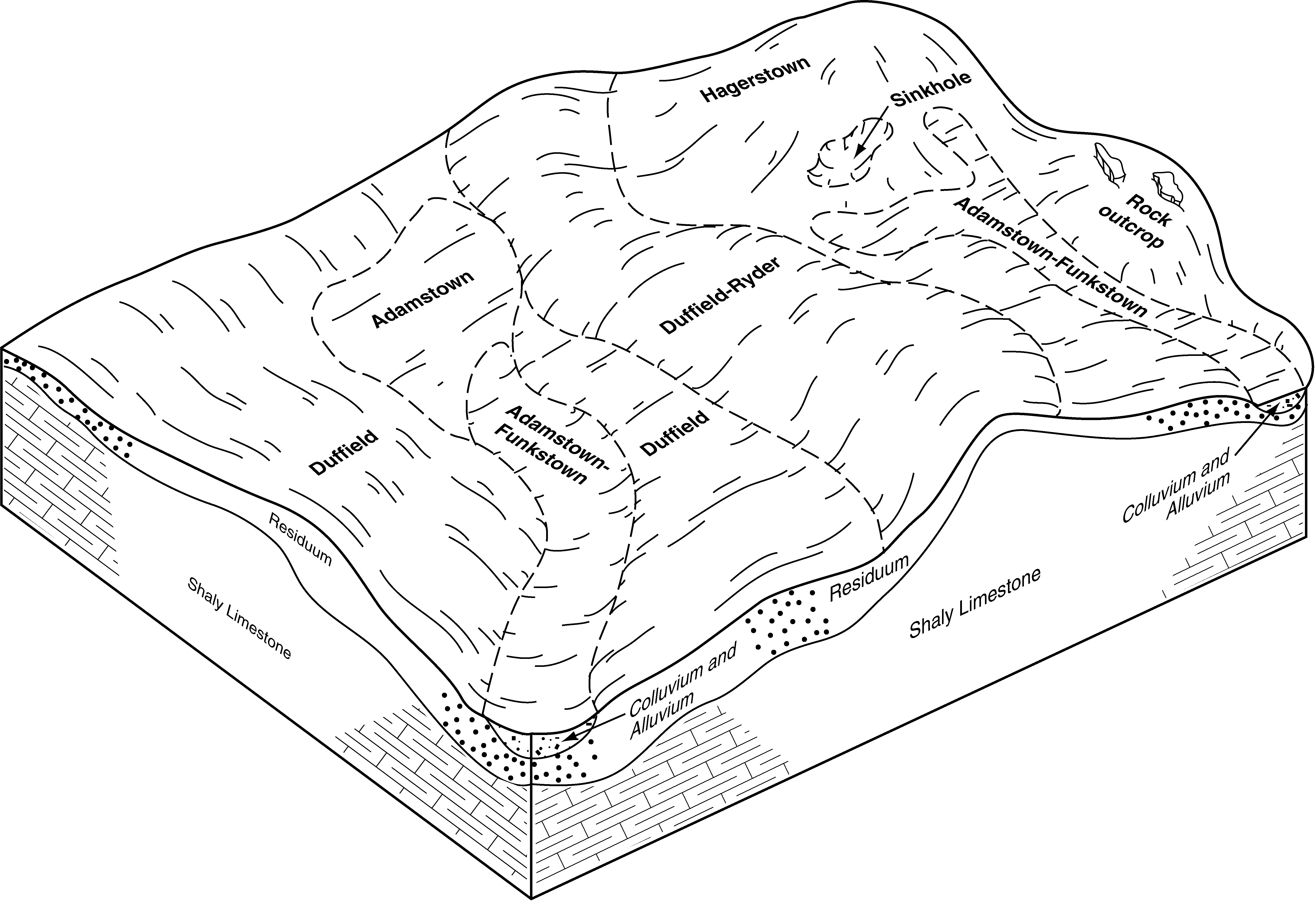
| Duffield-Ryder silt loams, 3 to 8 percent slopes | DtB | 9162 | 563858 | lxqz | md021 | 2001 | 1:12000 |
Duffield-Hagerstown-Urban land complex, 3 to 8 percent slopes | DwB | 3677 | 534961 | kynt | md021 | 2001 | 1:12000 |
Duffield-Ryder silt loams, 0 to 3 percent slopes | DtA | 2421 | 534803 | kyhq | md021 | 2001 | 1:12000 |
Duffield-Ryder silt loams, 8 to 15 percent slopes | DtC | 1173 | 534805 | kyhs | md021 | 2001 | 1:12000 |
Duffield and Ryder channery silt loams, 3 to 8 percent slopes | DuB | 1090 | 534806 | kyht | md021 | 2001 | 1:12000 |
Duffield and Ryder channery silt loams, 3 to 8 percent slopes, rocky | DvB | 202 | 558848 | lrjc | md021 | 2001 | 1:12000 |
Duffield silt loam, 3 to 8 percent slopes | DsB | 14400 | 534282 | kxyx | md043 | 1998 | 1:12000 |
Ryder-Duffield channery silt loams, 3 to 8 percent slopes | RmB | 6159 | 534647 | kybp | md043 | 1998 | 1:12000 |
Ryder-Duffield channery silt loams, 8 to 15 percent slopes | RmC | 4500 | 534648 | kybq | md043 | 1998 | 1:12000 |
Hagerstown-Duffield-Urban land complex, 0 to 8 percent slopes | HdB | 4420 | 534385 | ky27 | md043 | 1998 | 1:12000 |
Duffield silt loam, 8 to 15 percent slopes | DsC | 4029 | 534283 | kxyy | md043 | 1998 | 1:12000 |
Duffield-Rock outcrop complex, 8 to 15 percent slopes | DvC | 1687 | 534294 | kxz9 | md043 | 1998 | 1:12000 |
Ryder-Duffield channery silt loams, 15 to 25 percent slopes | RmD | 1667 | 534649 | kybr | md043 | 1998 | 1:12000 |
Hagerstown-Duffield-Urban land complex, 8 to 25 percent slopes | HdD | 1195 | 534386 | ky28 | md043 | 1998 | 1:12000 |
Duffield-Rock outcrop complex, 3 to 8 percent slopes | DvB | 1109 | 534292 | kxz7 | md043 | 1998 | 1:12000 |
Duffield silt loam, 0 to 3 percent slopes | DsA | 953 | 534280 | kxyv | md043 | 1998 | 1:12000 |
Duffield silt loam, 15 to 25 percent slopes | DsD | 615 | 534284 | kxyz | md043 | 1998 | 1:12000 |
Duffield silt loam, 3 to 8 percent slopes, very rocky | DuB | 609 | 534286 | kxz1 | md043 | 1998 | 1:12000 |
Duffield silt loam, 8 to 15 percent slopes, very rocky | DuC | 524 | 534288 | kxz3 | md043 | 1998 | 1:12000 |
Duffield-Rock outcrop complex, 15 to 25 percent slopes | DvD | 82 | 534295 | kxzb | md043 | 1998 | 1:12000 |
Duffield silt loam, 2 to 6 percent slopes | DufB | 1152 | 548600 | ldvs | nj019 | 1970 | 1:24000 |
Duffield silt loam, 6 to 12 percent slopes, eroded | DufC2 | 899 | 1478436 | 1lmfh | nj019 | 1970 | 1:24000 |
Duffield silt loam, 12 to 18 percent slopes, very rocky | DugDh | 338 | 1478438 | 1lmfk | nj019 | 1970 | 1:24000 |
Duffield silt loam, 0 to 12 percent slopes, rocky | DugCg | 242 | 548602 | ldvv | nj019 | 1970 | 1:24000 |
Duffield silt loam, 3 to 8 percent slopes | DbB | 40259 | 543005 | l719 | pa011 | 1997 | 1:24000 |
Urban land-Duffield complex, 0 to 8 percent slopes | UmB | 13077 | 543084 | l73v | pa011 | 1997 | 1:24000 |
Duffield-Ryder silt loams, 8 to 15 percent slopes | DfC | 8622 | 543006 | l71b | pa011 | 1997 | 1:24000 |
Duffield silt loam, 0 to 3 percent slopes | DbA | 3554 | 543004 | l718 | pa011 | 1997 | 1:24000 |
Urban land-Duffield complex, 8 to 25 percent slopes | UmD | 2337 | 543085 | l73w | pa011 | 1997 | 1:24000 |
Duffield-Ryder silt loams, 15 to 25 percent slopes | DfD | 1200 | 543007 | l71c | pa011 | 1997 | 1:24000 |
Hagerstown-Duffield silt loams, 3 to 8 percent slopes | HaB | 1029 | 543023 | l71w | pa011 | 1997 | 1:24000 |
Urban land-Duffield complex, 0 to 8 percent slopes | UnB | 5745 | 543739 | l7sz | pa017 | 1997 | 1:24000 |
Duffield silt loam, 3 to 8 percent slopes | DfB | 1795 | 543628 | 2v7gj | pa017 | 1997 | 1:24000 |
Duffield-Ryder silt loams, 8 to 15 percent slopes | DgC | 1359 | 543629 | l7pf | pa017 | 1997 | 1:24000 |
Duffield silt loam, 3 to 8 percent slopes | DfB | 172 | 641312 | 2v7gj | pa029 | 2008 | 1:24000 |
Duffield silt loam, 0 to 3 percent slopes | DfA | 122 | 641311 | 2v7gh | pa029 | 2008 | 1:24000 |
Duffield silt loam, 8 to 15 percent slopes | DfC | 71 | 2386599 | 2v7h9 | pa029 | 2008 | 1:24000 |
Urban land-Duffield complex, 0 to 8 percent slopes | UrhB | 58 | 1612246 | 1r3ny | pa029 | 2008 | 1:24000 |
Duffield silt loam, 3 to 8 percent slopes | DuB | 15704 | 693708 | r8vp | pa041 | 1980 | 1:15840 |
Duffield silt loam, 8 to 15 percent slopes | DuC | 4720 | 693709 | r8vq | pa041 | 1980 | 1:15840 |
Duffield silt loam, 0 to 3 percent slopes | DuA | 2343 | 693707 | r8vn | pa041 | 1980 | 1:15840 |
Duffield silt loam, 3 to 8 percent slopes, moderately eroded | DuB2 | 1800 | 540730 | l4nx | pa043 | 1967 | 1:15840 |
Duffield silt loam, 3 to 8 percent slopes | DsB | 10807 | 545107 | l973 | pa055 | 1999 | 1:24000 |
Duffield silt loam, 8 to 15 percent slopes | DsC | 1141 | 545108 | l974 | pa055 | 1999 | 1:24000 |
Urban land-Duffield complex, 0 to 8 percent slopes | UdB | 879 | 545212 | l9bh | pa055 | 1999 | 1:24000 |
Duffield silt loam, 0 to 3 percent slopes | DsA | 802 | 545106 | l972 | pa055 | 1999 | 1:24000 |
Urban land-Duffield complex, 8 to 15 percent slopes | UdC | 114 | 545213 | l9bj | pa055 | 1999 | 1:24000 |
Duffield silt loam, 3 to 8 percent slopes | DbB | 50729 | 542745 | 2v7gj | pa071 | 1982 | 1:15840 |
Duffield silt loam, 0 to 3 percent slopes | DbA | 21469 | 542744 | 2v7gh | pa071 | 1982 | 1:15840 |
Duffield-Ryder silt loams, 15 to 25 percent slopes | 1DfD | 2 | 557346 | lpyx | pa071 | 1982 | 1:15840 |
Duffield-Ryder silt loams, 8 to 15 percent slopes | 1DfC | 1 | 557345 | lpyw | pa071 | 1982 | 1:15840 |
Duffield silt loam, 3 to 8 percent slopes | DfB | 17199 | 541288 | l57x | pa075 | 1976 | 1:20000 |
Duffield silt loam, 0 to 3 percent slopes | DfA | 2575 | 541287 | l57w | pa075 | 1976 | 1:20000 |
Duffield silt loam, 8 to 15 percent slopes | DfC | 1422 | 541289 | l57y | pa075 | 1976 | 1:20000 |
Urban land-Duffield complex, 0 to 8 percent slopes | UmB | 21212 | 543201 | l77m | pa077 | 1997 | 1:24000 |
Duffield silt loam, 3 to 8 percent slopes | DbB | 5605 | 543135 | l75h | pa077 | 1997 | 1:24000 |
Urban land-Duffield complex, 8 to 25 percent slopes | UmD | 2319 | 543202 | l77n | pa077 | 1997 | 1:24000 |
Duffield silt loam, 0 to 3 percent slopes | DbA | 1704 | 543134 | l75g | pa077 | 1997 | 1:24000 |
Duffield-Ryder silt loams, 8 to 15 percent slopes | DfC | 1345 | 543136 | l75j | pa077 | 1997 | 1:24000 |
Duffield-Ryder silt loams, 15 to 25 percent slopes | DfD | 735 | 543137 | l75k | pa077 | 1997 | 1:24000 |
Urban land-Duffield complex, 0 to 8 percent slopes | UrhB | 4222 | 2229484 | 2dtyv | pa091 | 2008 | 1:12000 |
Duffield silt loam, 3 to 8 percent slopes | DuB | 1571 | 2379949 | 2v7gj | pa091 | 2008 | 1:12000 |
Duffield silt loam, 8 to 15 percent slopes | DuC | 382 | 2386596 | 2v7h9 | pa091 | 2008 | 1:12000 |
Urban land-Duffield complex, 8 to 25 percent slopes | UrhD | 41 | 2229485 | 2dtyw | pa091 | 2008 | 1:12000 |
Urban land-Duffield complex, 0 to 8 percent slopes | UoB | 14376 | 1948971 | 23f21 | pa095 | 2007 | 1:12000 |
Urban land-Duffield complex, 8 to 25 percent slopes | UoD | 2506 | 1948974 | 23f24 | pa095 | 2007 | 1:12000 |
Duffield silt loam, 3 to 8 percent slopes | DuB | 1874 | 1904611 | 21xx2 | pa095 | 2007 | 1:12000 |
Duffield-Ryder silt loams, 8 to 15 percent slopes | DvC | 825 | 1948778 | 23dvt | pa095 | 2007 | 1:12000 |
Ryder-Duffield silt loams, 3 to 8 percent slopes | RyB | 701 | 543324 | l7cl | pa095 | 2007 | 1:12000 |
Duffield silt loam, 0 to 3 percent slopes | DuA | 356 | 1904610 | 21xx1 | pa095 | 2007 | 1:12000 |
Duffield silt loam, 3 to 8 percent slopes | DuB | 1119 | 693933 | r92y | pa099 | 1980 | 1:15840 |
Duffield silt loam, 0 to 3 percent slopes | DuA | 369 | 693932 | r92x | pa099 | 1980 | 1:15840 |
Duffield silt loam, 8 to 15 percent slopes | DuC | 310 | 693934 | r92z | pa099 | 1980 | 1:15840 |
Duffield silt loam, 3 to 8 percent slopes | DsB | 3 | 1479516 | 2v7gj | pa101 | 1971 | 1:15840 |
Duffield silt loam, 3 to 8 percent slopes | DuB | 4027 | 542840 | 2v7gj | pa133 | 1990 | 1:24000 |
Duffield silt loam, 8 to 15 percent slopes | DuC | 1290 | 542841 | 2v7h9 | pa133 | 1990 | 1:24000 |
Duffield silt loam, 0 to 3 percent slopes | DuA | 808 | 542839 | 2v7gh | pa133 | 1990 | 1:24000 |
Duffield and Hagerstown silt loams, 15 to 25 percent slopes | DWD | 158 | 542838 | l6vx | pa133 | 1990 | 1:24000 |
Nicholson-Duffield silt loams, 3 to 8 percent slopes | 30B | 2559 | 516539 | kbhk | va043 | 1980 | 1:15840 |
Duffield-Ernest complex, 2 to 7 percent slopes | 11B | 6389 | 517071 | kc1q | va121 | 1980 | 1:15840 |
Duffield-Ernest complex, 7 to 15 percent slopes | 11C | 5033 | 517072 | kc1r | va121 | 1980 | 1:15840 |
Duffield gravelly silt loam, 3 to 8 percent slopes | DyB | 1829 | 516236 | kb5s | wv003 | 1997 | 1:24000 |
Duffield silt loam, 3 to 8 percent slopes | DuB | 905 | 516234 | kb5q | wv003 | 1997 | 1:24000 |
Duffield gravelly silt loam, 8 to 15 percent slopes | DyC | 853 | 516237 | kb5t | wv003 | 1997 | 1:24000 |
Duffield silt loam, 8 to 15 percent slopes | DuC | 582 | 516235 | kb5r | wv003 | 1997 | 1:24000 |
Duffield-Ryder complex, 15 to 25 percent slopes | DyD | 2479 | 1710335 | 1vdr3 | wv037 | | 1:24000 |
Duffield-Ryder complex, 8 to 15 percent slopes | DyC | 697 | 1710334 | 1vdr2 | wv037 | | 1:24000 |
Duffield-Ryder complex, 3 to 8 percent slopes | DyB | 360 | 1710333 | 1vdr1 | wv037 | | 1:24000 |
Duffield-Ryder complex, 25 to 35 percent slopes | DyE | 100 | 1710336 | 1vdr4 | wv037 | | 1:24000 |
Duffield silt loam, 3 to 8 percent slopes | DuB | 1005 | 515401 | k99v | wv075 | 1992 | 1:24000 |
Duffield silt loam, 8 to 15 percent slopes | DuC | 655 | 515402 | k99w | wv075 | 1992 | 1:24000 |


