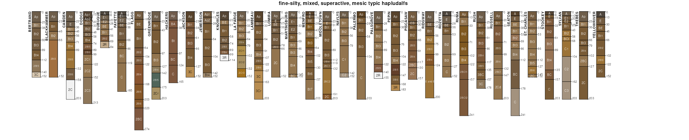
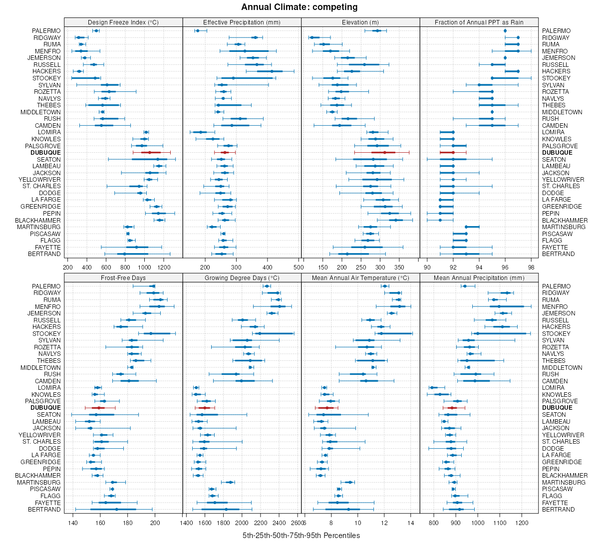
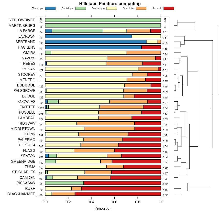
| Dubuque silt loam, 9 to 14 percent slopes, moderately eroded | 703D2 | 5801 | 402489 | 2t7yr | ia005 | 1992 | 1:15840 |
Dubuque silt loam, 14 to 18 percent slopes, moderately eroded | 703E2 | 3435 | 402491 | 2t7yn | ia005 | 1992 | 1:15840 |
Dubuque silt loam, 14 to 18 percent slopes | 703E | 3152 | 402490 | 2t7yp | ia005 | 1992 | 1:15840 |
Dubuque silt loam, 9 to 14 percent slopes | 703D | 2141 | 402488 | 2t7ys | ia005 | 1992 | 1:15840 |
Dubuque silt loam, 18 to 25 percent slopes | 703F | 1043 | 402492 | 2t7ym | ia005 | 1992 | 1:15840 |
Dubuque silt loam, 5 to 9 percent slopes, moderately eroded | 703C2 | 828 | 402487 | 2t7yt | ia005 | 1992 | 1:15840 |
Dubuque silt loam, 5 to 9 percent slopes | 703C | 261 | 402486 | 2t7yv | ia005 | 1992 | 1:15840 |
Fayette-Dubuque silt loams, 18 to 30 percent slopes | 497F | 13134 | 404281 | fkpb | ia043 | 1979 | 1:15840 |
Dubuque silt loam, 14 to 18 percent slopes, moderately eroded | 703E2 | 9474 | 404237 | 2t7yn | ia043 | 1979 | 1:15840 |
Dubuque silt loam, 14 to 18 percent slopes | 703E | 5460 | 404236 | 2t7yp | ia043 | 1979 | 1:15840 |
Dubuque silt loam, 18 to 25 percent slopes | 703F | 3839 | 404239 | 2t7ym | ia043 | 1979 | 1:15840 |
Dubuque silt loam, 9 to 14 percent slopes, moderately eroded | 703D2 | 1814 | 404235 | 2t7yr | ia043 | 1979 | 1:15840 |
Fayette-Dubuque silt loams, 14 to 18 percent slopes | 497E | 1354 | 404280 | fkp9 | ia043 | 1979 | 1:15840 |
Dubuque silt loam, 9 to 14 percent slopes | 703D | 861 | 404234 | 2t7ys | ia043 | 1979 | 1:15840 |
Dubuque silty clay loam, 20 to 30 inches to limestone, 14 to 18 percent slopes, severely eroded | 183E3 | 361 | 404238 | fkmy | ia043 | 1979 | 1:15840 |
Dubuque silt loam, 5 to 9 percent slopes | 703C | 229 | 404233 | 2t7yv | ia043 | 1979 | 1:15840 |
Dubuque silt loam, 14 to 18 percent slopes | 703E | 619 | 405018 | 2t7yp | ia055 | 1984 | 1:15840 |
Dubuque silt loam, 5 to 9 percent slopes | 703C | 460 | 405017 | 2t7yv | ia055 | 1984 | 1:15840 |
Dubuque silt loam, 14 to 18 percent slopes, moderately eroded | 703E2 | 2395 | 405409 | 2t7yn | ia061 | 1983 | 1:15840 |
Dubuque silt loam, 14 to 18 percent slopes | 703E | 1717 | 405408 | 2t7yp | ia061 | 1983 | 1:15840 |
Dubuque silt loam, 9 to 14 percent slopes, moderately eroded | 703D2 | 1591 | 405407 | 2t7yr | ia061 | 1983 | 1:15840 |
Fayette-Dubuque-Schapville complex, 18 to 30 percent slopes | 497F | 1576 | 405451 | flx2 | ia061 | 1983 | 1:15840 |
Dubuque silt loam, 9 to 14 percent slopes | 703D | 1040 | 405406 | 2t7ys | ia061 | 1983 | 1:15840 |
Fayette-Dubuque-Jacwin complex, 14 to 25 percent slopes | 497F | 3947 | 405790 | fm80 | ia065 | 1975 | 1:15840 |
Fayette-Dubuque-Jacwin complex, 25 to 40 percent slopes | 497G | 1276 | 405791 | fm81 | ia065 | 1975 | 1:15840 |
Dubuque silt loam, 18 to 25 percent slopes | 703F | 1091 | 405735 | 2t7ym | ia065 | 1975 | 1:15840 |
Dubuque silt loam, 14 to 18 percent slopes, moderately eroded | 703E2 | 1031 | 405734 | 2t7yn | ia065 | 1975 | 1:15840 |
Dubuque silt loam, 14 to 18 percent slopes | 703E | 600 | 405733 | 2t7yp | ia065 | 1975 | 1:15840 |
Dubuque silt loam, 9 to 14 percent slopes, moderately eroded | 703D2 | 458 | 405732 | 2t7yr | ia065 | 1975 | 1:15840 |
Dubuque silt loam, 5 to 9 percent slopes | 703C | 140 | 405731 | 2t7yv | ia065 | 1975 | 1:15840 |
Dubuque silt loam, 14 to 18 percent slopes, moderately eroded | 703E2 | 733 | 407555 | 2t7yn | ia097 | 1988 | 1:15840 |
Dubuque silt loam, 9 to 14 percent slopes | 703D | 598 | 407552 | 2t7ys | ia097 | 1988 | 1:15840 |
Dubuque silt loam, 9 to 14 percent slopes, moderately eroded | 703D2 | 577 | 407553 | 2t7yr | ia097 | 1988 | 1:15840 |
Dubuque silt loam, 18 to 25 percent slopes | 703F | 571 | 407556 | 2t7ym | ia097 | 1988 | 1:15840 |
Dubuque silt loam, 14 to 18 percent slopes | 703E | 459 | 407554 | 2t7yp | ia097 | 1988 | 1:15840 |
Dubuque silt loam, 5 to 9 percent slopes, moderately eroded | 703C2 | 212 | 407551 | 2t7yt | ia097 | 1988 | 1:15840 |
Dubuque silt loam, 18 to 25 percent slopes | 703F | 798 | 408193 | 2t7ym | ia105 | 1988 | 1:15840 |
Dubuque silt loam, 5 to 14 percent slopes | 703D | 236 | 408192 | 2t7yw | ia105 | 1988 | 1:15840 |
Dubuque silt loam, moderately deep, 2 to 5 percent slopes | 183B | 250 | 409640 | fr86 | ia131 | 1971 | 1:15840 |
Dubuque silt loam, moderately deep, 5 to 9 percent slopes | 183C | 198 | 409641 | fr87 | ia131 | 1971 | 1:15840 |
Dubuque silt loam, 14 to 18 percent slopes, moderately eroded | 703E2 | 8635 | 1008301 | 2t7yn | ia191 | 2005 | 1:12000 |
Dubuque silt loam, 9 to 14 percent slopes, moderately eroded | 703D2 | 4514 | 756310 | 2t7yr | ia191 | 2005 | 1:12000 |
Dubuque silt loam, 18 to 25 percent slopes | 703F | 1380 | 1008421 | 2t7ym | ia191 | 2005 | 1:12000 |
Dubuque silt loam, 5 to 9 percent slopes, moderately eroded | 703C2 | 1011 | 756309 | 2t7yt | ia191 | 2005 | 1:12000 |
Dubuque silt loam, 10 to 18 percent slopes, moderately eroded | 29D2 | 596 | 995982 | 2t7xs | il015 | 2005 | 1:12000 |
Dunbarton-Dubuque silt loams, 15 to 25 percent slopes, moderately eroded | 873E2 | 12669 | 1949603 | 2t7z9 | il085 | 1990 | 1:12000 |
Dunbarton-Dubuque silt loams, 7 to 15 percent slopes, moderately eroded | 873D2 | 11436 | 1949602 | 2t7z8 | il085 | 1990 | 1:12000 |
Dubuque silt loam, 10 to 18 percent slopes, moderately eroded | 29D2 | 7061 | 1949629 | 2t7xs | il085 | 1990 | 1:12000 |
Dubuque silt loam, 5 to 10 percent slopes, moderately eroded | 29C2 | 3697 | 1949627 | 2t7xn | il085 | 1990 | 1:12000 |
Dubuque-Orthents-Fayette complex, 12 to 25 percent slopes, pitted | 681E | 291 | 1949585 | 23fpv | il085 | 1990 | 1:12000 |
Dubuque silt loam, 10 to 18 percent slopes, moderately eroded | 29D2 | 744 | 208592 | 2t7xs | il141 | 2005 | 1:12000 |
Dubuque silt loam, 5 to 10 percent slopes, moderately eroded | 29C2 | 8476 | 1591949 | 2t7xn | il177 | 2006 | 1:12000 |
Dubuque silt loam, 10 to 18 percent slopes, moderately eroded | 29D2 | 3416 | 1651435 | 2t7xs | il177 | 2006 | 1:12000 |
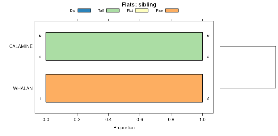
Dubuque and Whalan silt loams, 18 to 45 percent slopes | Dx | 22644 | 2216727 | 2ddpb | mn045 | 2008 | 1:12000 |
Dubuque and Whalan silt loams, 12 to 17 percent slopes, moderately eroded | Dv | 10170 | 2216732 | 2ddph | mn045 | 2008 | 1:12000 |
Dubuque and Whalan silt loams, 7 to 11 percent slopes, moderately eroded | Du | 5660 | 2216730 | 2ddpf | mn045 | 2008 | 1:12000 |
Dubuque and Whalan silt loams, 2 to 6 percent slopes | Ds | 3144 | 2216728 | 2ddpc | mn045 | 2008 | 1:12000 |
Fayette-Pepin-Dubuque complex, sinkhole karst, 12 to 18 percent slopes, moderately eroded | N533D2 | 450 | 2372357 | 2kmmn | mn045 | 2008 | 1:12000 |
Dubuque silt loam, shallow, 12 to 18 percent slopes, moderately eroded | DrD2 | 5086 | 2216333 | 2dd8m | mn157 | 2008 | 1:12000 |
Dubuque silt loam, 12 to 18 percent slopes, moderately eroded | DnD2 | 4826 | 2216325 | 2dd8c | mn157 | 2008 | 1:12000 |
Dubuque silt loam, shallow, 18 to 25 percent slopes | DrE | 4161 | 2216334 | 2dd8n | mn157 | 2008 | 1:12000 |
Dubuque silt loam, shallow, 25 to 35 percent slopes | DrF | 1941 | 2216337 | 2dd8r | mn157 | 2008 | 1:12000 |
Dubuque silt loam, 18 to 25 percent slopes | DnE | 1726 | 2216326 | 2dd8d | mn157 | 2008 | 1:12000 |
Dubuque silt loam, 6 to 12 percent slopes, moderately eroded | DnC2 | 1723 | 2216331 | 2dd8k | mn157 | 2008 | 1:12000 |
Dubuque silt loam, shallow, 6 to 12 percent slopes, moderately eroded | DrC2 | 1249 | 2216338 | 2dd8s | mn157 | 2008 | 1:12000 |
Dubuque silt loam, shallow, 2 to 6 percent slopes | DrB | 235 | 2216335 | 2dd8p | mn157 | 2008 | 1:12000 |
Dubuque silt loam, 25 to 35 percent slopes | DnF | 233 | 2216329 | 2dd8h | mn157 | 2008 | 1:12000 |
Dubuque silt loam, 2 to 6 percent slopes | DnB | 231 | 2216327 | 2dd8f | mn157 | 2008 | 1:12000 |
Dubuque soils, deep, 10 to 15 percent slopes, moderately eroded | 1175CD | 16319 | 1454350 | 1ktcj | wi043 | 1959 | 1:20000 |
Dubuque soils, deep, 6 to 10 percent slopes, moderately eroded | 1175C2 | 12263 | 1454349 | 1ktch | wi043 | 1959 | 1:20000 |
Dubuque soils, deep, 15 to 20 percent slopes, moderately eroded | 1175D2 | 3953 | 1454351 | 1ktck | wi043 | 1959 | 1:20000 |
Dubuque soils, deep, 20 to 30 percent slopes, moderately eroded | 1175E2 | 1032 | 1454352 | 1ktcl | wi043 | 1959 | 1:20000 |
Dubuque soils, deep, 6 to 12 percent slopes, moderately eroded | 1175C2 | 211 | 1454929 | 1ktz6 | wi049 | 1960 | 1:20000 |
Dubuque soils, deep, 12 to 20 percent slopes, moderately eroded | 1175D2 | 80 | 1454930 | 1ktz7 | wi049 | 1960 | 1:20000 |
Dubuque stony silt loam, 2 to 6 percent slopes, moderately eroded | 1180B2 | 26 | 424582 | g7t6 | wi049 | 1960 | 1:20000 |
Fayette and Dubuque soils and pits, moderately sloping, moderately eroded | 1102C2 | 197 | 424818 | g81t | wi065 | 1964 | 1:15840 |
Fayette and Dubuque soils and pits, gently sloping, moderately eroded | 1102B2 | 114 | 424817 | g81s | wi065 | 1964 | 1:15840 |
Fayette and Dubuque soils and pits, moderately steep, moderately eroded | 1102D2 | 112 | 424819 | g81v | wi065 | 1964 | 1:15840 |