| Okiota-Dubakella-Henneke complex, 15 to 50 percent slopes | 542 | 883 | 461663 | hhdc | ca011 | 1999 | 1:24000 |
Dubakella stony loam, 30 to 50 percent slopes | DuE | 68 | 458632 | hd7l | ca021 | 1961 | 1:20000 |
Okiota-Henneke-Dubakella association, 15 to 50 percent slopes | 193 | 9632 | 459596 | hf7p | ca033 | 1985 | 1:24000 |
Okiota-Henneke-Dubakella association, 15 to 50 percent slopes | 193l | 117 | 813833 | w9vp | ca055 | 1974 | 1:24000 |
Dubakella-Ipish complex, 30 to 50 percent slopes | 144 | 8350 | 459053 | hdp5 | ca602 | 1978 | 1:24000 |
Rock outcrop-Dubakella complex, 30 to 50 percent slopes | 213 | 3050 | 459122 | hdrd | ca602 | 1978 | 1:24000 |
Dubakella-Ipish complex, 5 to 30 percent slopes | 143 | 2980 | 459052 | hdp4 | ca602 | 1978 | 1:24000 |
DUBAKELLA COBBLY CLAY LOAM, 30 TO 50 PERCENT SLOPES | 139 | 1093 | 466039 | hmyj | ca606 | 1990 | 1:24000 |
WEITCHPEC-DUBAKELLA COMPLEX, 30 TO 50 PERCENT SLOPES | 210 | 627 | 466112 | hn0w | ca606 | 1990 | 1:24000 |
DUBAKELLA COBBLY CLAY LOAM, 50 TO 75 PERCENT SLOPES | 140 | 515 | 466040 | hmyk | ca606 | 1990 | 1:24000 |
DUBAKELLA STONY LOAM, 30 TO 50 PERCENT SLOPES | 141 | 490 | 466042 | hmym | ca606 | 1990 | 1:24000 |
DUBAKELLA COBBLY CLAY LOAM, 15 TO 30 PERCENT SLOPES | 138 | 213 | 466038 | hmyh | ca606 | 1990 | 1:24000 |
Rock outcrop-Dubakella complex, 5 to 50 percent slopes | RrE | 1992 | 460241 | hfxh | ca619 | 1970 | 1:24000 |
Dubakella, shallow variant-Rock outcrop complex, 2 to 50 percent slopes | DrE | 1374 | 460209 | hfwg | ca619 | 1970 | 1:24000 |
Dubakella very stony loam, 9 to 50 percent slopes | 143 | 1950 | 460307 | hfzm | ca620 | 1975 | 1:24000 |
Dubakella stony loam, 30 to 50 percent slopes | DyE | 4023 | 460738 | hgfj | ca645 | 1961 | 1:20000 |
Neuns-Dubakella complex, 30 to 50 percent slopes | NpE | 551 | 460879 | hgl2 | ca645 | 1961 | 1:20000 |
Dubakella stony loam, 10 to 30 percent slopes | DyD | 286 | 460737 | hgfh | ca645 | 1961 | 1:20000 |
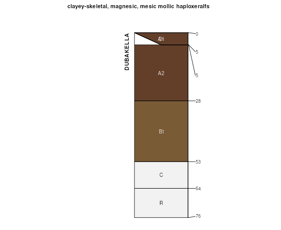
Dubakella family, 30 to 70 percent slopes. | 122 | 10422 | 470343 | hsfc | ca702 | 1984 | 1:24000 |
Lithic Mollic Haploxeralfs-Dubakella family association, 15 to 70 percent slopes. | 155 | 8418 | 470376 | hsgf | ca702 | 1984 | 1:24000 |
Dubakella-Ipish complex, 5 to 30 percent slopes | 143sc | 541 | 1905893 | 21z7f | ca702 | 1984 | 1:24000 |
Dubakella-Ipish complex, 30 to 50 percent slopes | 144sc | 308 | 1905895 | 21z7h | ca702 | 1984 | 1:24000 |
Rock outcrop-Dubakella-Weitchpec familes complex, 40 to 60 percent slopes. | 256st | 147 | 1906090 | 21zfs | ca702 | 1984 | 1:24000 |
Rock outcrop-Dubakella complex, 30 to 50 percent slopes | 213sc | 50 | 1905960 | 21z9l | ca702 | 1984 | 1:24000 |
Dubakella-Weitchpec families complex, 20 to 40 percent slopes. | 47 | 6818 | 470645 | hsr3 | ca707 | 1983 | 1:24000 |
Rock outcrop-Dubakella-Weitchpec familes complex, 40 to 60 percent slopes. | 256 | 5754 | 470854 | hsyv | ca707 | 1983 | 1:24000 |
Ishi Pishi, deep-Dubakella families complex, 20 to 40 percent slopes. | 152 | 3210 | 470750 | hsvh | ca707 | 1983 | 1:24000 |
Dubakella family, 40 to 60 percent slopes. | 44 | 3050 | 470642 | hsr0 | ca707 | 1983 | 1:24000 |
Dubakella-Weitchpec families complex, 40 to 60 percent slopes. | 48 | 2937 | 470646 | hsr4 | ca707 | 1983 | 1:24000 |
Dubakella family-Rock outcrop complex, 20 to 40 percent slopes. | 46 | 2548 | 470644 | hsr2 | ca707 | 1983 | 1:24000 |
Dunsmuir-Dubakella-Weitchpec families complex, 40 to 60 percent slopes. | 52 | 2201 | 470650 | hsr8 | ca707 | 1983 | 1:24000 |
Beaughton-Dubakella families complex, 20 to 40 percent slopes. | 13 | 2155 | 470611 | hsq0 | ca707 | 1983 | 1:24000 |
Dubakella-Beaughton families complex, 30 to 70 percent slopes. | 45 | 2140 | 470643 | hsr1 | ca707 | 1983 | 1:24000 |
Weitchpec-Dubakella families complex, 20 to 40 percent slopes. | 344 | 1806 | 470942 | ht1p | ca707 | 1983 | 1:24000 |
Dubakella family, 20 to 40 percent slopes. | 43 | 1418 | 470641 | hsqz | ca707 | 1983 | 1:24000 |
Dubakella-Ipish complex, 30 to 50 percent slopes | 144sc | 1115 | 1867662 | 20pg5 | ca707 | 1983 | 1:24000 |
Dubakella stony loam, 30 to 50 percent slopes | DyEtc | 736 | 1868283 | 20q36 | ca707 | 1983 | 1:24000 |
Rock outcrop-Dubakella complex, 30 to 50 percent slopes | 213sc | 628 | 1867690 | 20ph2 | ca707 | 1983 | 1:24000 |
Dubakella cobbly clay loam, 30 to 50 percent slopes | 139tw | 362 | 1868760 | 20qll | ca707 | 1983 | 1:24000 |
Dubakella--Weitchpec families complex, 60 to 80 percent slopes. | 49 | 337 | 470647 | hsr5 | ca707 | 1983 | 1:24000 |
Henneke-Dubakella families complex, 40 to 60 percent slopes. | 91 | 115 | 470687 | hssg | ca707 | 1983 | 1:24000 |
Dubakella-Ipish complex, 5 to 30 percent slopes | 143sc | 67 | 1867661 | 20pg4 | ca707 | 1983 | 1:24000 |
Dubakella cobbly clay loam, 15 to 30 percent slopes | 138tw | 65 | 1868758 | 20qlj | ca707 | 1983 | 1:24000 |
Dubakella stony loam, 10 to 30 percent slopes | DyDtc | 38 | 1868281 | 20q34 | ca707 | 1983 | 1:24000 |
Dubakella very gravelly loam, 10 to 30 percent slopes | 132 | 870 | 2747797 | 2q1yn | ca709 | 2010 | 1:24000 |
Rock outcrop-Dubakella family complex, 70 to 100 percent slopes. | 240 | 12428 | 471249 | htcl | ca713 | 1984 | 1:24000 |
Dubakella family, 30 to 50 percent slopes. | 145 | 4556 | 471154 | ht8j | ca713 | 1984 | 1:24000 |
Dubakella family, 2 to 30 percent slopes. | 144 | 4157 | 471153 | ht8h | ca713 | 1984 | 1:24000 |
Dubakella family, 50 to 70 percent slopes. | 146 | 2496 | 471155 | ht8k | ca713 | 1984 | 1:24000 |
Dubakella family, 20 to 70 percent slopes, slumped. | 147 | 542 | 471156 | ht8l | ca713 | 1984 | 1:24000 |
Dubakella-Rock outcrop complex, 20 to 80 percent slopes. | 148 | 532 | 471157 | ht8m | ca713 | 1984 | 1:24000 |
Rock outcrop-Dubakella-Dubakella variant complex, 40 to 75 perce nt slopes | RDG | 6672 | 464784 | hln1 | ca719 | 1982 | 1:24000 |
Dubakella-Dubakella variant-Rock outcrop complex, 30 to 50 percent slopes | DUF | 2744 | 464642 | hlhg | ca719 | 1982 | 1:24000 |
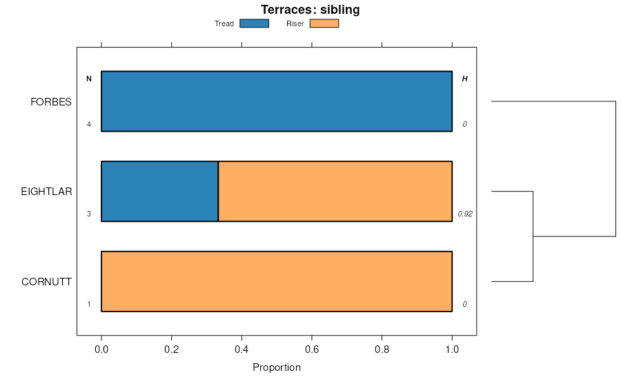
Forbes-Dubakella complex, 2 to 30 percent slopes | ISE | 1366 | 464698 | hlk8 | ca719 | 1982 | 1:24000 |
Forbes-Dubakella complex, 30 to 50 percent slopes | ISF | 1361 | 464700 | hlkb | ca719 | 1982 | 1:24000 |
Dubakella-Dubakella variant-Rock outcrop complex, 2 to 30 percent slopes | DUE | 1050 | 464641 | hlhf | ca719 | 1982 | 1:24000 |
Rock outcrop-Dubakella-Dubakella variant complex, 2 to 40 percen t slopes | RDE | 856 | 464783 | hln0 | ca719 | 1982 | 1:24000 |
Forbes-Dubakella complex, 2 to 30 percent slopes, altered | ISE5 | 613 | 464699 | hlk9 | ca719 | 1982 | 1:24000 |
Dubakella very stony loam, 9 to 50 percent slopes | 143pc | 60 | 1585910 | 1q78d | ca719 | 1982 | 1:24000 |
Dubakella-Cornutt-Pearsoll complex, 20 to 60 percent south slopes | 94F | 943 | 65577 | 267d | or015 | 1995 | 1:24000 |
Cornutt-Dubakella complex, 35 to 55 percent south slopes | 21F | 28020 | 469447 | hrhg | or033 | 1979 | 1:20000 |
Dubakella-Pearsoll complex, 35 to 70 percent south slopes | 29F | 20541 | 469456 | hrhr | or033 | 1979 | 1:20000 |
Dubakella-Pearsoll complex, 35 to 75 percent north slopes | 28F | 16876 | 469455 | hrhq | or033 | 1979 | 1:20000 |
Cornutt-Dubakella complex, 35 to 55 percent north slopes | 20F | 12569 | 469446 | hrhf | or033 | 1979 | 1:20000 |
Eightlar-Dubakella complex, 35 to 65 percent north slopes | 32F | 6688 | 469461 | hrhx | or033 | 1979 | 1:20000 |
Eightlar-Dubakella complex, 35 to 65 percent south slopes | 33F | 6147 | 469462 | hrhy | or033 | 1979 | 1:20000 |
Cornutt-Dubakella complex, 20 to 35 percent slopes | 19E | 4024 | 469442 | hrh9 | or033 | 1979 | 1:20000 |
Cornutt-Dubakella complex, 7 to 20 percent slopes | 19D | 1122 | 469441 | hrh8 | or033 | 1979 | 1:20000 |
Dubakella very stony clay loam, rocky, 35 to 70 percent slopes | 50G | 730 | 469744 | hrt1 | or632 | 1989 | 1:20000 |
Dubakella very stony clay loam, rocky, 12 to 35 percent slopes | 50E | 679 | 469743 | hrt0 | or632 | 1989 | 1:20000 |
Pearsoll-Dubakella complex, rocky, 20 to 60 percent slopes | 140G | 442 | 469610 | hrnq | or632 | 1989 | 1:20000 |
Pearsoll-Dubakella complex, 30 to 70 percent south slopes | 186F | 10383 | 66505 | 276b | or649 | 1994 | 1:24000 |
Dubakella-Pearsoll complex, 30 to 70 percent north slopes | 68F | 3246 | 67033 | 27rc | or649 | 1994 | 1:24000 |
Dubakella-Pearsoll complex, 5 to 30 percent slopes | 67E | 2465 | 67022 | 27r0 | or649 | 1994 | 1:24000 |
Dubakella very stony clay loam, 30 to 60 percent north slopes | 65F | 431 | 67019 | 27qx | or649 | 1994 | 1:24000 |
Dubakella very stony clay loam, 30 to 60 percent south slopes | 66F | 360 | 67021 | 27qz | or649 | 1994 | 1:24000 |