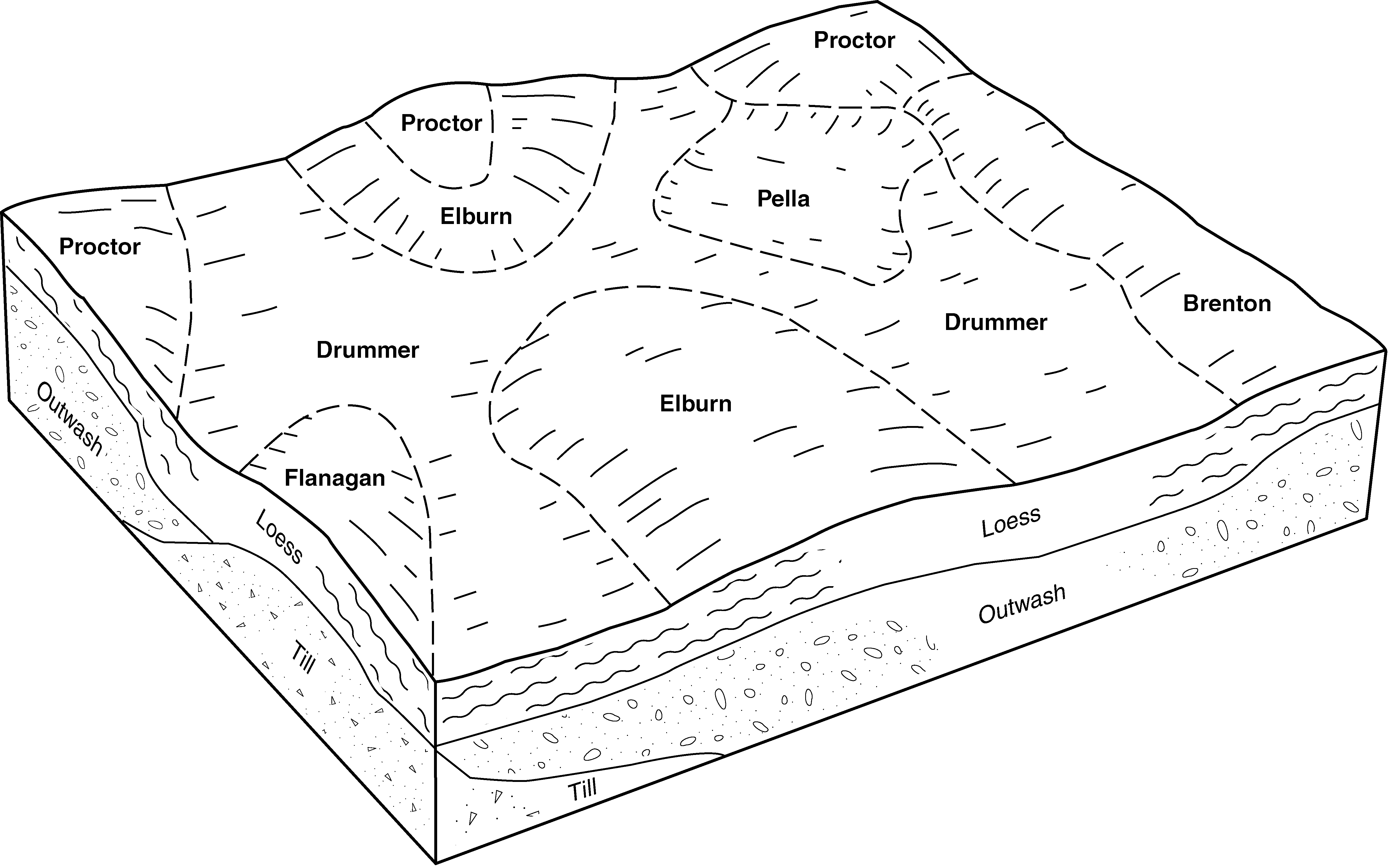
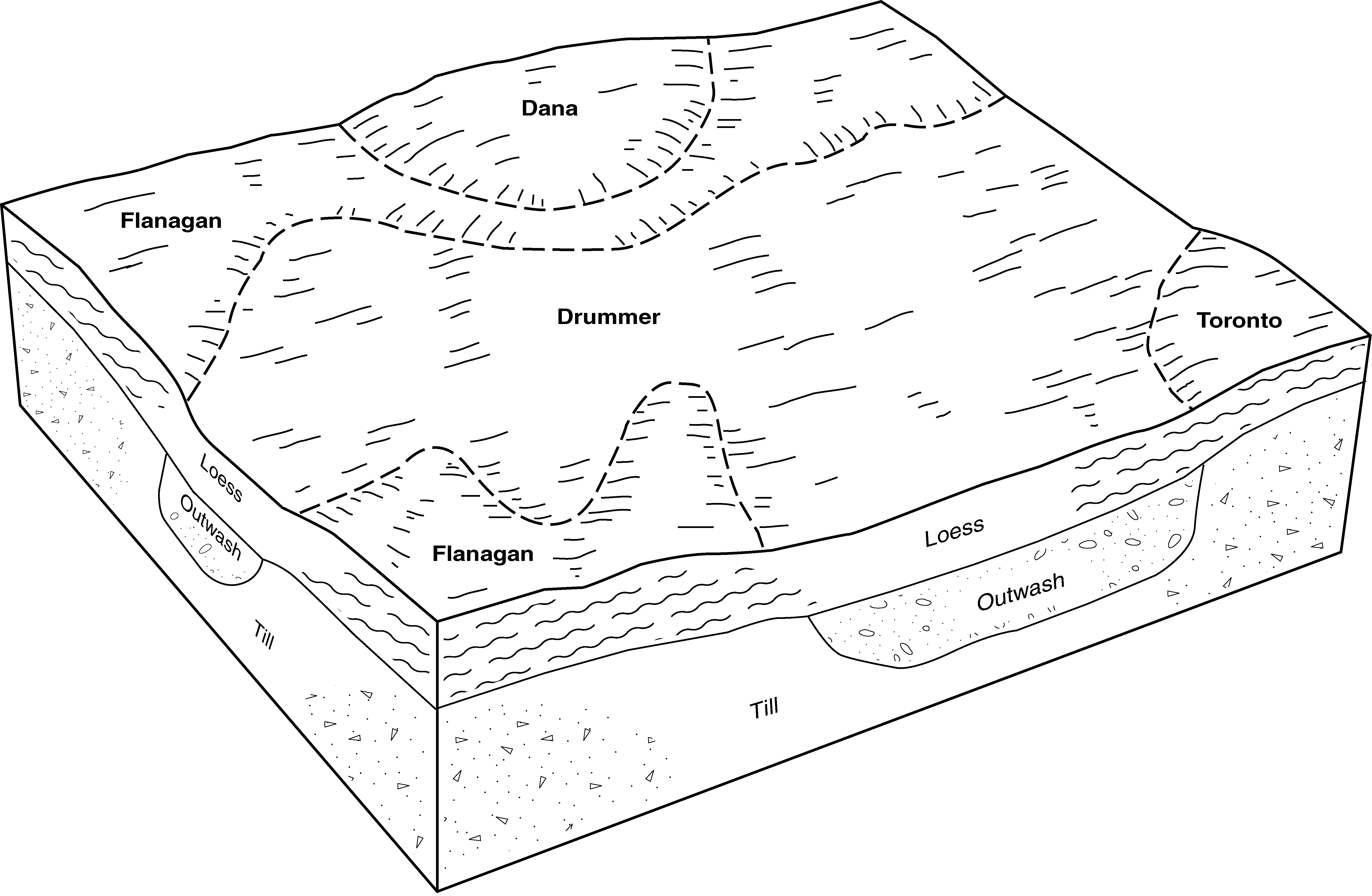
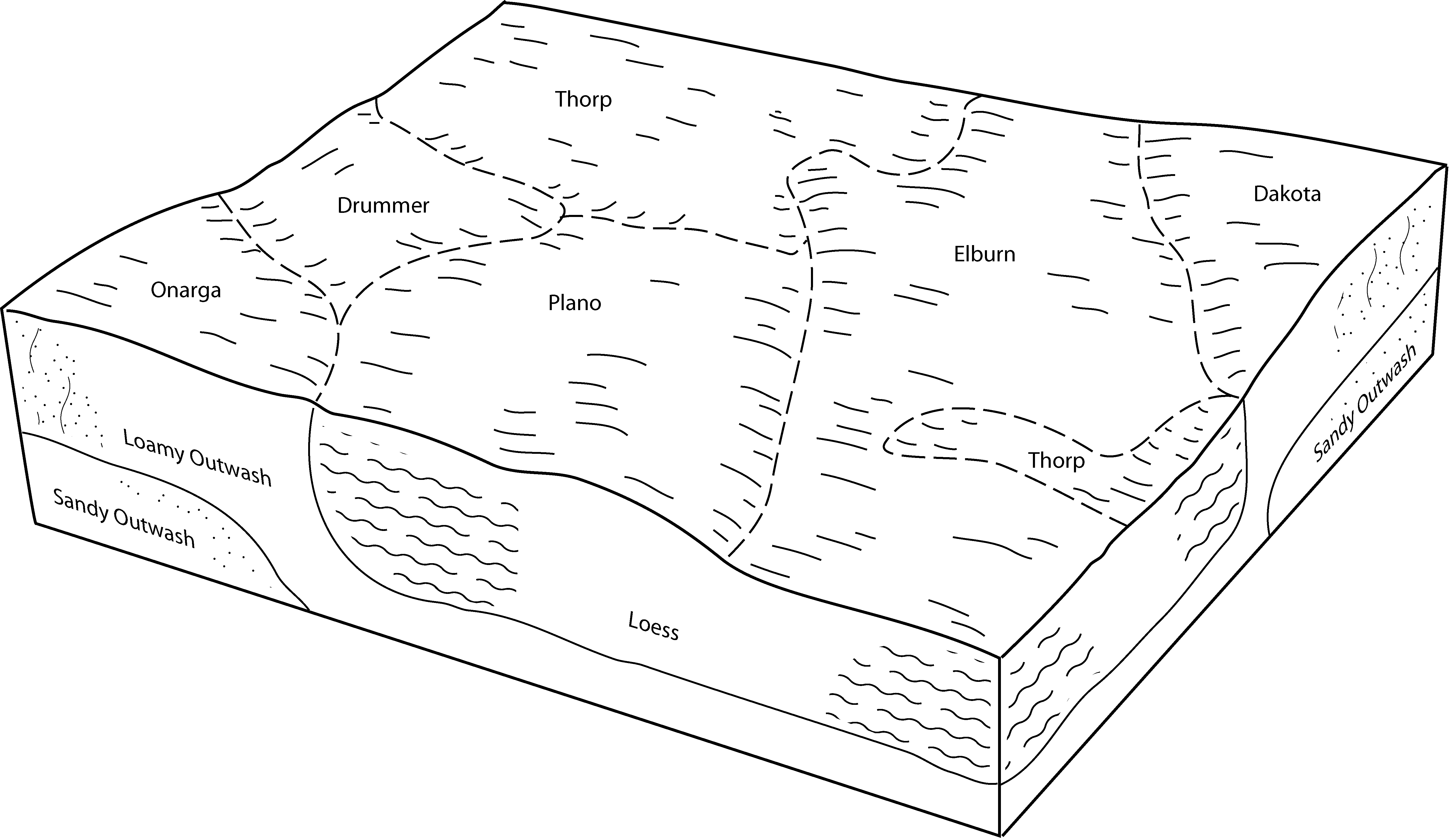
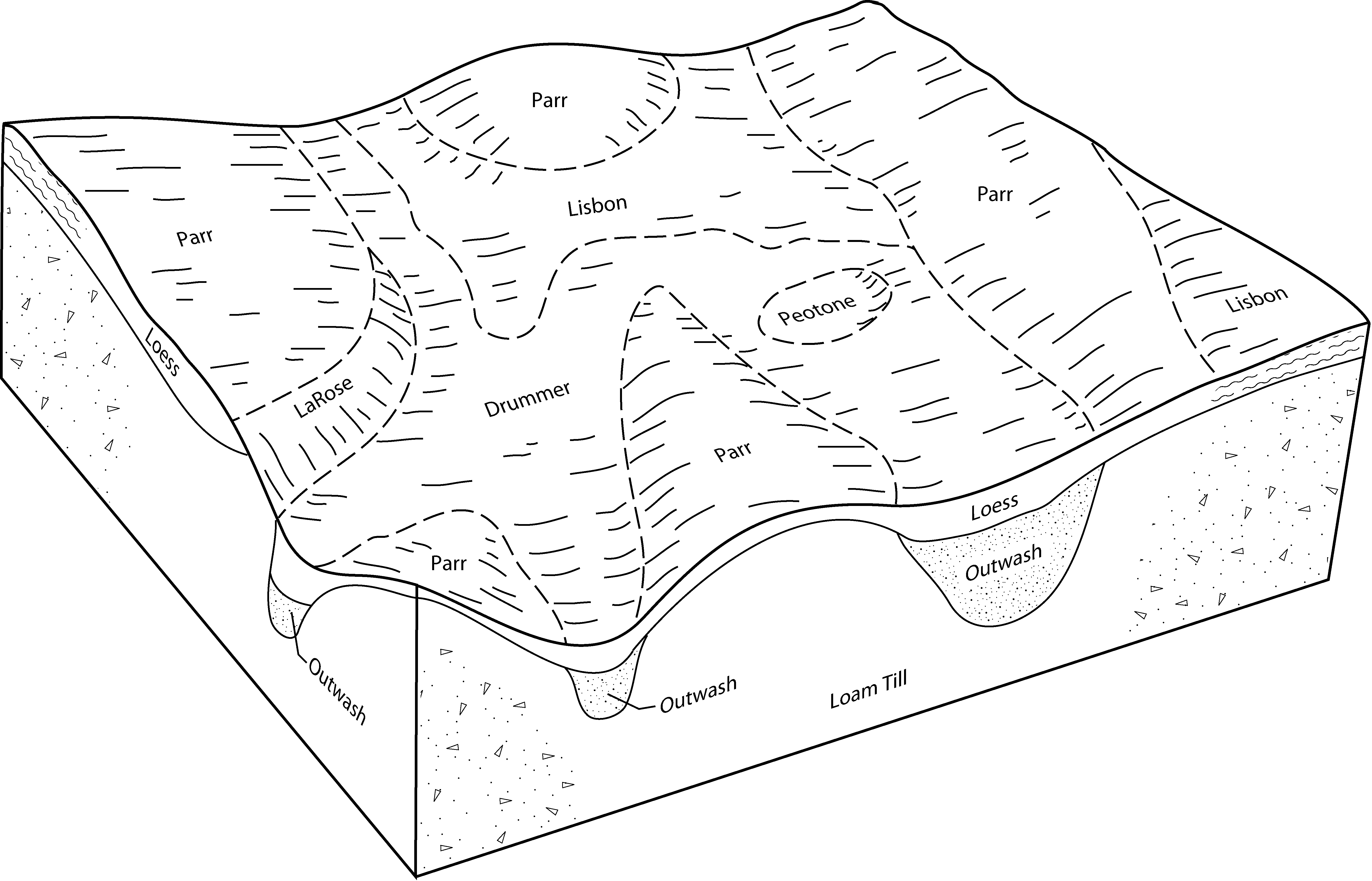
| Drummer silty clay loam, 0 to 2 percent slopes | 152A | 14561 | 1395352 | 2ssrz | il007 | 2006 | 1:12000 |
Drummer silt loam, 0 to 2 percent slopes, overwash | 152A+ | 203 | 1612646 | 1r42v | il007 | 2006 | 1:12000 |
Drummer silty clay loam, 0 to 2 percent slopes | 152A | 18099 | 1862699 | 2ssrz | il011 | 2007 | 1:12000 |
Drummer silty clay loam, 0 to 2 percent slopes | 152A | 457 | 796099 | 2ssrz | il015 | 2005 | 1:12000 |
Drummer silty clay loam, 0 to 2 percent slopes | 152A | 254334 | 242963 | 2ssrz | il019 | 1999 | 1:12000 |
Drummer silty clay loam, 0 to 2 percent slopes | 152A | 1656 | 261769 | 2ssrz | il021 | 1999 | 1:12000 |
Drummer silty clay loam, 0 to 2 percent slopes | 152A | 2986 | 1596125 | 2ssrz | il023 | 2006 | 1:12000 |
Drummer silty clay loam, 0 to 2 percent slopes | 152A | 71868 | 1428391 | 2ssrz | il029 | 2005 | 1:12000 |
Drummer-Milford silty clay loams, 0 to 2 percent slopes | 722A | 30022 | 1547466 | 2ytd3 | il029 | 2005 | 1:12000 |
Drummer silty clay loam, 0 to 2 percent slopes | 152A | 4246 | 2108713 | 2ssrz | il031 | 2008 | 1:12000 |
Drummer-Barrington-Mundelein complex, 1 to 6 percent slopes | 848B | 1848 | 2383981 | 2l0qm | il031 | 2008 | 1:12000 |
Drummer silty clay loam, 0 to 2 percent slopes | 152A | 2582 | 174797 | 2ssrz | il035 | 1992 | 1:15840 |
Drummer silty clay loam, 0 to 2 percent slopes | 152A | 42603 | 183901 | 2ssrz | il037 | 1998 | 1:12000 |
Drummer-Milford silty clay loams, 0 to 2 percent slopes | 722A | 84450 | 1019440 | 2ytd3 | il041 | 2004 | 1:12000 |
Drummer silty clay loam, 0 to 2 percent slopes | 152A | 19556 | 200187 | 2ssrz | il041 | 2004 | 1:12000 |
Drummer silty clay loam, 0 to 2 percent slopes | 152A | 11661 | 183358 | 2ssrz | il043 | 1998 | 1:12000 |
Drummer-Barrington-Mundelein complex, 1 to 6 percent slopes | 848B | 1135 | 183454 | 64ww | il043 | 1998 | 1:12000 |
Drummer silty clay loam, undrained, 0 to 2 percent slopes | 1152A | 113 | 183344 | 64sb | il043 | 1998 | 1:12000 |
Drummer silty clay loam, 0 to 2 percent slopes | 152A | 129165 | 843547 | 2ssrz | il045 | 1997 | 1:12000 |
Drummer silty clay loam, 0 to 2 percent slopes | 152A | 31823 | 198311 | 2ssrz | il053 | 2001 | 1:12000 |
Drummer silty clay loam, 0 to 2 percent slopes | 152A | 27260 | 1143979 | 2ssrz | il063 | 2005 | 1:12000 |
Drummer silty clay loam, 0 to 2 percent slopes | 152A | 12305 | 244659 | 2ssrz | il073 | 2001 | 1:12000 |
Drummer silty clay loam, 0 to 2 percent slopes | 152A | 54208 | 198805 | 2ssrz | il089 | 2000 | 1:12000 |
Drummer silty clay loam, 0 to 2 percent slopes | 152A | 27328 | 1715092 | 2ssrz | il093 | 2007 | 1:12000 |
Drummer silty clay loam, 0 to 2 percent slopes | 152A | 55131 | 1029931 | 2ssrz | il099 | 2006 | 1:12000 |
Drummer silty clay loam, 0 to 2 percent slopes | 152A | 17476 | 923944 | 2ssrz | il103 | 2004 | 1:12000 |
Drummer silt loam, 0 to 2 percent slopes, overwash | 152A+ | 680 | 923922 | 100dy | il103 | 2004 | 1:12000 |
Drummer silty clay loam, 0 to 2 percent slopes | 152A | 13210 | 176933 | 2ssrz | il105 | 1991 | 1:15840 |
Drummer and Elpaso silty clay loams, 0 to 2 percent slopes | 721A | 384 | 2648880 | 2ytpz | il105 | 1991 | 1:15840 |
Drummer silty clay loam, 0 to 2 percent slopes | 152A | 4468 | 1596005 | 2ssrz | il107 | 2006 | 1:12000 |
Drummer silty clay loam, stream terrace, 0 to 2 percent slopes | 9152A | 1032 | 3004698 | 2ww9n | il107 | 2006 | 1:12000 |
Drummer silty clay loam, 0 to 2 percent slopes | 152A | 2973 | 182431 | 2ssrz | il111 | 1997 | 1:12000 |
Drummer and Elpaso silty clay loams, 0 to 2 percent slopes | 721A | 69001 | 620960 | 2ytpz | il113 | 2000 | 1:12000 |
Drummer silty clay loam, 0 to 2 percent slopes | 152A | 9395 | 199078 | 2ssrz | il113 | 2000 | 1:12000 |
Drummer silty clay loam, 0 to 2 percent slopes | 152A | 39319 | 1913937 | 2ssrz | il115 | 2007 | 1:12000 |
Drummer-Milford silty clay loams, 0 to 2 percent slopes | 722A | 36377 | 1913971 | 2ytd3 | il115 | 2007 | 1:12000 |
Drummer silty clay loam, 0 to 2 percent slopes | 152A | 134 | 182088 | 2ssrz | il123 | 1997 | 1:15840 |
Drummer silty clay loam, stream terrace, 0 to 2 percent slopes | 9152A | 4585 | 3004697 | 2ww9n | il125 | 1989 | 1:15840 |
Drummer silty clay loam, 0 to 2 percent slopes | 152A | 80 | 177762 | 2ssrz | il125 | 1989 | 1:15840 |
Drummer silty clay loam, stream terrace, 0 to 2 percent slopes | 9152A | 4120 | 1404548 | 2ww9n | il129 | 2005 | 1:12000 |
Drummer-Milford silty clay loams, 0 to 2 percent slopes | 722A | 78249 | 780654 | 2ytd3 | il139 | 1999 | 1:12000 |
Drummer silty clay loam, 0 to 2 percent slopes | 152A | 19110 | 1144363 | 2ssrz | il141 | 2005 | 1:12000 |
Drummer silty clay loam, 0 to 2 percent slopes | 152A | 1791 | 208963 | 2ssrz | il143 | 1986 | 1:15840 |
Drummer silty clay loam, 0 to 2 percent slopes | 152A | 46717 | 1910895 | 2ssrz | il147 | 2009 | 1:12000 |
Drummer-Milford silty clay loams, 0 to 2 percent slopes | 722A | 22612 | 1912951 | 2ytd3 | il147 | 2009 | 1:12000 |
Drummer-Milford silty clay loams, 0 to 2 percent slopes, rarely flooded | 7722A | 4276 | 1949516 | 23fmm | il147 | 2009 | 1:12000 |
Drummer and Elpaso silty clay loams, 0 to 2 percent slopes | 721A | 1130 | 1912954 | 2ytpz | il147 | 2009 | 1:12000 |
Drummer silty clay loam, 0 to 2 percent slopes | 152A | 52717 | 178997 | 2ssrz | il173 | 1990 | 1:15840 |
Drummer silty clay loam, 0 to 2 percent slopes | 152A | 3801 | 179062 | 2ssrz | il175 | 1992 | 1:15840 |
Drummer silty clay loam, 0 to 2 percent slopes | 152A | 1456 | 1591917 | 2ssrz | il177 | 2006 | 1:12000 |
Drummer silty clay loam, 0 to 2 percent slopes | 152A | 953 | 179362 | 2ssrz | il179 | 1991 | 1:15840 |
Drummer silty clay loam, 0 to 2 percent slopes | 152A | 95134 | 1612751 | 2ssrz | il183 | 2006 | 1:12000 |
Drummer silty clay loam, 0 to 2 percent slopes | 152A | 12797 | 793035 | 2ssrz | il195 | 2003 | 1:12000 |
Drummer silty clay loam, 0 to 2 percent slopes | 152A | 6399 | 262299 | 2ssrz | il197 | 2002 | 1:12000 |
Drummer silty clay loam, 0 to 2 percent slopes | 152A | 4784 | 173967 | 2ssrz | il201 | 1997 | 1:12000 |
Drummer silty clay loam, 0 to 2 percent slopes | 152A | 1664 | 1913187 | 2ssrz | il203 | 2008 | 1:12000 |
Drummer and Elpaso silty clay loams, 0 to 2 percent slopes | 721A | 518 | 2108948 | 2ytpz | il203 | 2008 | 1:12000 |
Drummer silty clay loam, 0 to 2 percent slopes | Du | 8489 | 164556 | 2ssrz | in007 | 1985 | 1:15840 |
Drummer silty clay loam, stratified sandy substratum | Dx | 5342 | 164558 | 5j7b | in007 | 1985 | 1:15840 |
Drummer silty clay loam, gravelly substratum | Dv | 1406 | 164557 | 5j79 | in007 | 1985 | 1:15840 |
Drummer silty clay loam | Dr | 14819 | 162326 | 5fxb | in023 | 1978 | 1:20000 |
Sable-Drummer silty clay loams | Sc | 9925 | 162357 | 5fyb | in023 | 1978 | 1:20000 |
Pella, sandy substratum-Drummer, till substratum, silty clay loams | Ps | 86 | 3291276 | 5fqw | in023 | 1978 | 1:20000 |
Drummer silty clay loam, 0 to 1 percent slopes | DpbA | 2713 | 242389 | 8470 | in045 | 1999 | 1:12000 |
Sable-Drummer silty clay loams | Sc | 13 | 3291334 | 5fyb | in067 | 1967 | 1:20000 |
Drummer silty clay loam | Du | 10094 | 163012 | 5gmg | in107 | 1984 | 1:15840 |
Drummer soils | Du | 42102 | 163953 | 5hlt | in157 | 1990 | 1:15840 |
Pella, sandy substratum-Drummer, till substratum, silty clay loams | Ps | 15221 | 162157 | 5fqw | in159 | 1985 | 1:15840 |
Sable-Drummer silty clay loams | Sc | 51 | 3291365 | 5fyb | in159 | 1985 | 1:15840 |
Drummer silty clay loams | Dw | 34442 | 163106 | 5gqh | in171 | 1987 | 1:15840 |
Drummer silty clay loam, gravelly substratum | Dx | 1621 | 163107 | 5gqj | in171 | 1987 | 1:15840 |
Drummer silty clay loam, gravelly substratum | Dr | 3371 | 171707 | 5rny | oh023 | 1997 | 1:15840 |
Drummer silt loam, gravelly substratum | 7452A | 725 | 3268633 | g777 | wi059 | 2023 | 1:15840 |
Drummer silt loam, gravelly substratum | 7452A | 662 | 3403295 | g93b | wi079 | 2023 | 1:15840 |
Drummer silt loam, gravelly substratum | 7452A | 772 | 3268765 | g777 | wi101 | 2023 | 1:15840 |
Drummer silt loam, gravelly substratum | 7452A | 5739 | 425611 | g8wd | wi127 | 1967 | 1:15840 |
Drummer silt loam, gravelly substratum | 7452A | 561 | 425719 | g8zw | wi131 | 1967 | 1:15840 |
Drummer silt loam, gravelly substratum | 7452A | 1135 | 3403385 | g93b | wi133 | 2023 | 1:15840 |


