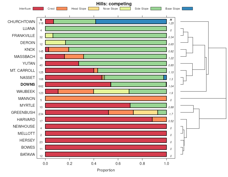
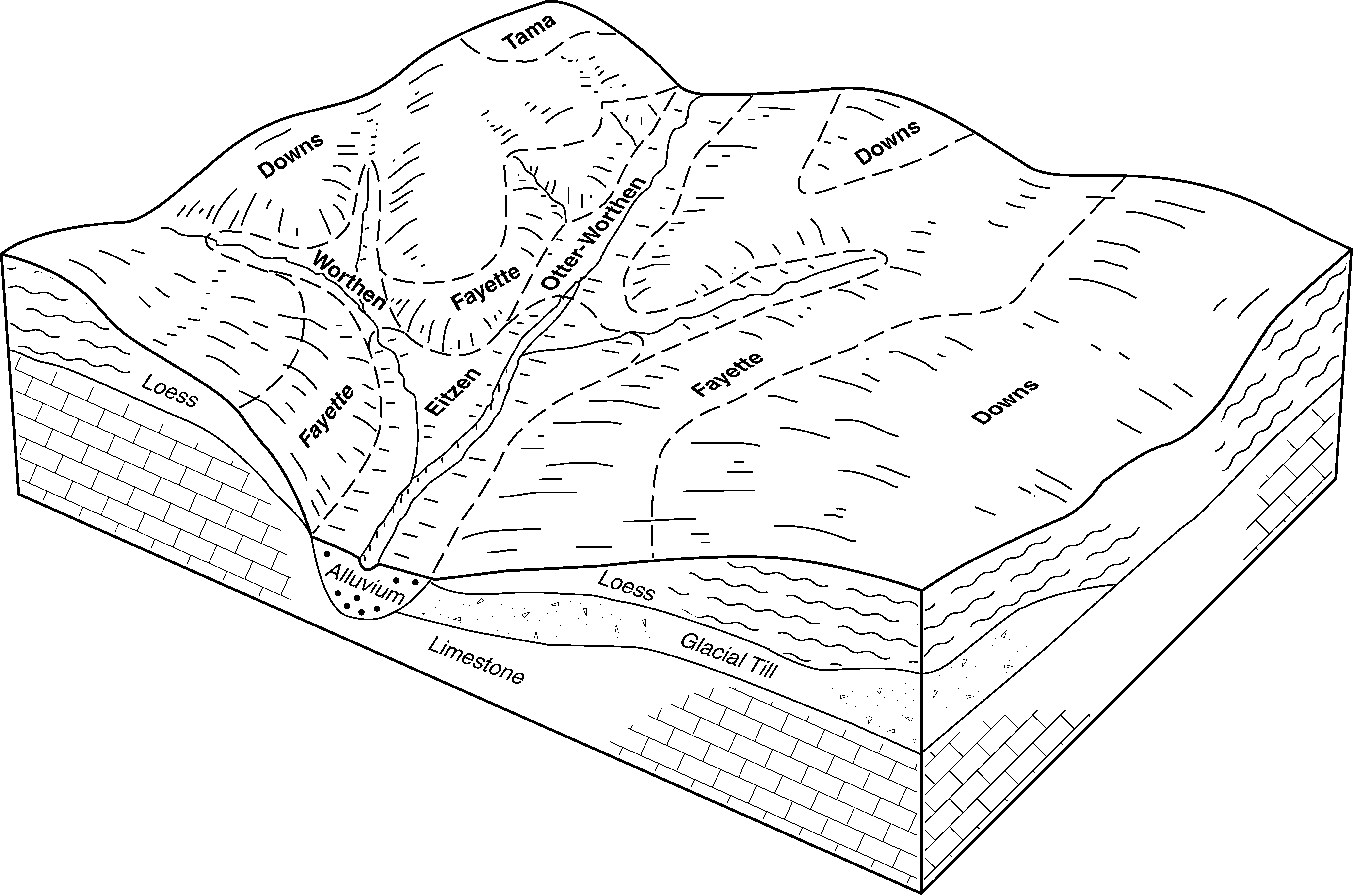
| Downs silt loam, 5 to 9 percent slopes, moderately eroded | 162C2 | 29991 | 402359 | 2tc4v | ia005 | 1992 | 1:15840 |
Downs silt loam, 2 to 6 percent slopes | 162B | 14440 | 402356 | 2tc4t | ia005 | 1992 | 1:15840 |
Downs silt loam, 9 to 14 percent slopes, moderately eroded | 162D2 | 10063 | 402361 | 2tc4w | ia005 | 1992 | 1:15840 |
Downs silt loam, 2 to 6 percent slopes, moderately eroded | 162B2 | 3143 | 402357 | 2tc4q | ia005 | 1992 | 1:15840 |
Downs silt loam, 14 to 18 percent slopes, moderately eroded | 162E2 | 330 | 402363 | 2tc4y | ia005 | 1992 | 1:15840 |
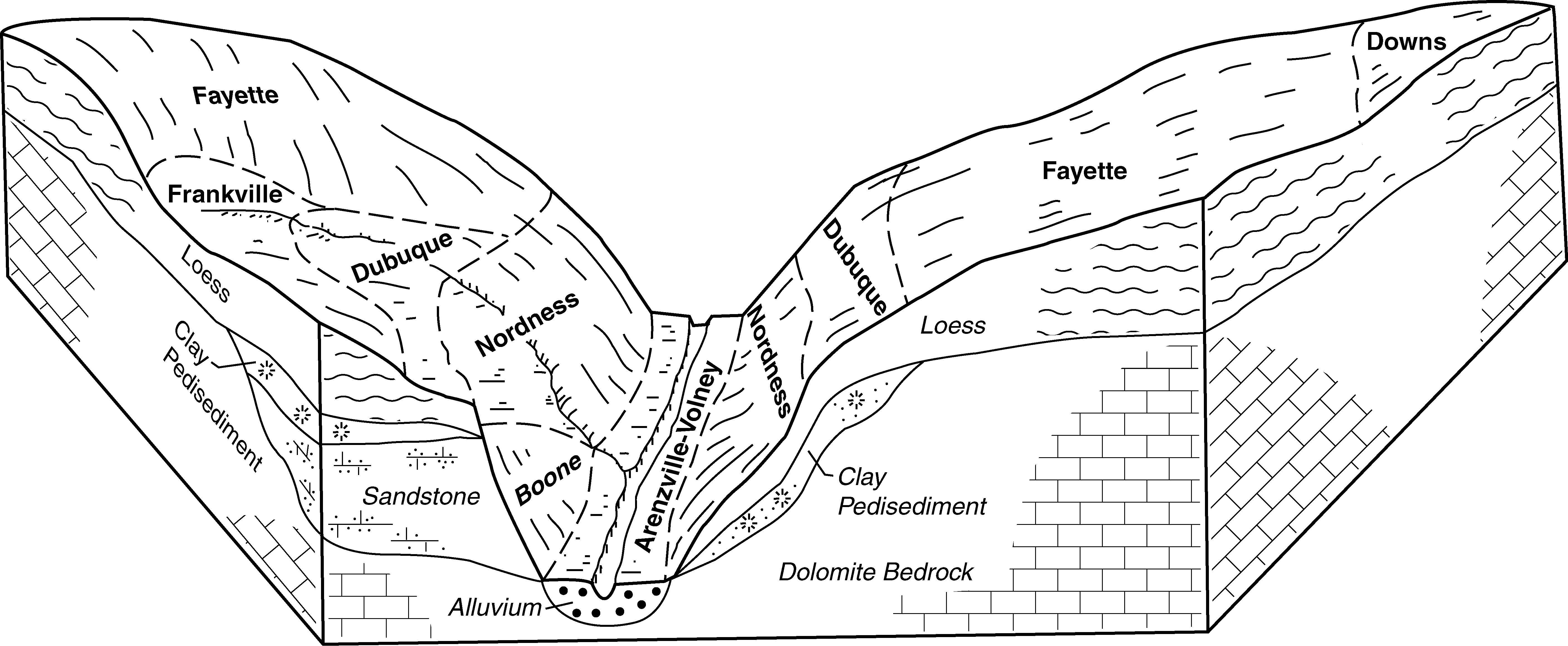
Downs silt loam, till plain, 2 to 5 percent slopes | M162B | 1303 | 402828 | 2tgr8 | ia011 | 1977 | 1:15840 |
Downs silt loam, till plain, 5 to 9 percent slopes, eroded | M162C2 | 1095 | 402830 | 2tgrc | ia011 | 1977 | 1:15840 |
Downs silt loam, till plain, 5 to 9 percent slopes | M162C | 918 | 402829 | 2tgrb | ia011 | 1977 | 1:15840 |
Downs silt loam, paha, 2 to 5 percent slopes | P162B | 709 | 2909692 | 2tgrs | ia011 | 1977 | 1:15840 |
Downs silt loam, paha, 5 to 9 percent slopes | P162C | 588 | 2909704 | 2tgrt | ia011 | 1977 | 1:15840 |
Downs silt loam, paha, 5 to 9 percent slopes, eroded | P162C2 | 579 | 2909716 | 2tgrv | ia011 | 1977 | 1:15840 |
Downs silt loam, paha, 9 to 14 percent slopes, eroded | P162D2 | 422 | 2909731 | 2tgrx | ia011 | 1977 | 1:15840 |
Downs silt loam, till plain, 9 to 14 percent slopes, eroded | M162D2 | 388 | 402832 | 2tgrf | ia011 | 1977 | 1:15840 |
Downs silt loam, paha, 9 to 14 percent slopes | P162D | 351 | 2909725 | 2tgrw | ia011 | 1977 | 1:15840 |
Downs silt loam, till plain, 9 to 14 percent slopes | M162D | 170 | 402831 | 2tgrd | ia011 | 1977 | 1:15840 |
Downs silt loam, paha, 5 to 9 percent slopes, eroded | P162C2 | 1915 | 403354 | 2tgrv | ia023 | 1978 | 1:15840 |
Downs silt loam, paha, 5 to 9 percent slopes | P162C | 243 | 403353 | 2tgrt | ia023 | 1978 | 1:15840 |
Downs silt loam, till plain, 5 to 9 percent slopes, eroded | M162C2 | 14334 | 1397075 | 2tgrc | ia031 | 2008 | 1:12000 |
Downs silt loam, till plain, 9 to 14 percent slopes, eroded | M162D2 | 10575 | 1397076 | 2tgrf | ia031 | 2008 | 1:12000 |
Downs silt loam, till plain, 2 to 5 percent slopes | M162B | 8329 | 1397073 | 2tgr8 | ia031 | 2008 | 1:12000 |
Downs silty clay loam, till plain, 9 to 14 percent slopes, severely eroded | M162D3 | 2845 | 1902233 | 2tgrn | ia031 | 2008 | 1:12000 |
Downs silt loam, till plain, 5 to 9 percent slopes | M162C | 1405 | 1397074 | 2tgrb | ia031 | 2008 | 1:12000 |
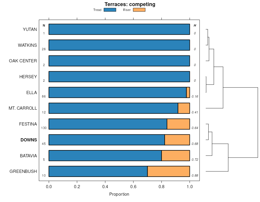
Downs silt loam, terrace, 2 to 5 percent slopes | 462B | 1032 | 1397122 | 1hwtg | ia031 | 2008 | 1:12000 |
Downs silty clay loam, till plains, 14 to 18 percent slopes, severely eroded | M162E3 | 734 | 1902234 | 2tgrq | ia031 | 2008 | 1:12000 |
Downs silt loam, terrace, 5 to 9 percent slopes | 462C | 509 | 1902250 | 21vfx | ia031 | 2008 | 1:12000 |
Downs silt loam, paha, 2 to 5 percent slopes | P162B | 383 | 2909693 | 2tgrs | ia031 | 2008 | 1:12000 |
Downs silt loam, paha, 5 to 9 percent slopes, eroded | P162C2 | 378 | 2909718 | 2tgrv | ia031 | 2008 | 1:12000 |
Downs silt loam, paha, 9 to 14 percent slopes, eroded | P162D2 | 132 | 2909732 | 2tgrx | ia031 | 2008 | 1:12000 |
Downs silt loam, paha, 5 to 9 percent slopes | P162C | 33 | 2909705 | 2tgrt | ia031 | 2008 | 1:12000 |
Downs silty clay loam, paha, 9 to 14 percent slopes, severely eroded | P162D3 | 25 | 2909712 | 2tgry | ia031 | 2008 | 1:12000 |
Downs silt loam, 5 to 9 percent slopes, moderately eroded | 162C2 | 28629 | 404211 | 2tc4v | ia043 | 1979 | 1:15840 |
Downs silt loam, 9 to 14 percent slopes, moderately eroded | 162D2 | 25581 | 404213 | 2tc4w | ia043 | 1979 | 1:15840 |
Downs silt loam, 2 to 6 percent slopes | 162B | 7817 | 404209 | 2tc4t | ia043 | 1979 | 1:15840 |
Downs silt loam, 14 to 18 percent slopes, moderately eroded | 162E2 | 697 | 404214 | 2tc4y | ia043 | 1979 | 1:15840 |
Downs silt loam, 5 to 9 percent slopes, moderately eroded | 162C2 | 13951 | 404356 | 2tc4v | ia045 | 1978 | 1:15840 |
Downs silt loam, 9 to 14 percent slopes, moderately eroded | 162D2 | 9902 | 404358 | 2tc4w | ia045 | 1978 | 1:15840 |
Downs silt loam, 2 to 6 percent slopes | 162B | 3195 | 404354 | 2tc4t | ia045 | 1978 | 1:15840 |
Downs silt loam, 14 to 18 percent slopes, moderately eroded | 162E2 | 1975 | 404359 | 2tc4y | ia045 | 1978 | 1:15840 |
Downs silt loam, till plain, 9 to 14 percent slopes, eroded | M162D2 | 285 | 2918235 | 2tgrf | ia045 | 1978 | 1:15840 |
Downs silt loam, paha, 9 to 14 percent slopes, eroded | P162D2 | 275 | 2909733 | 2tgrx | ia045 | 1978 | 1:15840 |
Downs silt loam, till plain, 5 to 9 percent slopes | M162C | 170 | 2909802 | 2tgrb | ia045 | 1978 | 1:15840 |
Downs silt loam, till plain, 5 to 9 percent slopes, eroded | M162C2 | 111 | 2909812 | 2tgrc | ia045 | 1978 | 1:15840 |
Downs silt loam, paha, 2 to 5 percent slopes | P162B | 110 | 2909689 | 2tgrs | ia045 | 1978 | 1:15840 |
Downs silt loam, paha, 5 to 9 percent slopes, eroded | P162C2 | 107 | 2909719 | 2tgrv | ia045 | 1978 | 1:15840 |
Downs silt loam, paha, 14 to 18 percent slopes, eroded | P162E2 | 63 | 2909739 | 2tgrz | ia045 | 1978 | 1:15840 |
Downs silt loam, till plain, 14 to 18 percent slopes, eroded | M162E2 | 56 | 2918250 | 2tgrg | ia045 | 1978 | 1:15840 |
Downs silt loam, terrace, 5 to 9 percent slopes | 462C | 51 | 404432 | 2tc52 | ia045 | 1978 | 1:15840 |
Downs silt loam, till plain, 2 to 5 percent slopes | M162B | 47 | 2909768 | 2tgr8 | ia045 | 1978 | 1:15840 |
Downs silt loam, paha, 5 to 9 percent slopes | P162C | 36 | 2909706 | 2tgrt | ia045 | 1978 | 1:15840 |
Downs silt loam, terrace, 2 to 5 percent slopes | 462B | 24 | 404431 | 2tc4z | ia045 | 1978 | 1:15840 |
Downs silt loam, paha, 9 to 14 percent slopes | P162D | 9 | 2909726 | 2tgrw | ia045 | 1978 | 1:15840 |
Downs silt loam, till plain, 9 to 14 percent slopes | M162D | 8 | 2909828 | 2tgrd | ia045 | 1978 | 1:15840 |
Downs silt loam, 5 to 9 percent slopes, moderately eroded | 162C2 | 6967 | 404991 | 2tc4v | ia055 | 1984 | 1:15840 |
Downs silt loam, 9 to 14 percent slopes, moderately eroded | 162D2 | 4936 | 404993 | 2tc4w | ia055 | 1984 | 1:15840 |
Downs silt loam, paha, 2 to 5 percent slopes | P162B | 1611 | 2909690 | 2tgrs | ia055 | 1984 | 1:15840 |
Downs silt loam, paha, 9 to 14 percent slopes, eroded | P162D2 | 1236 | 2909734 | 2tgrx | ia055 | 1984 | 1:15840 |
Downs silt loam, paha, 5 to 9 percent slopes, eroded | P162C2 | 1161 | 2909720 | 2tgrv | ia055 | 1984 | 1:15840 |
Downs silt loam, paha, 5 to 9 percent slopes | P162C | 965 | 2909707 | 2tgrt | ia055 | 1984 | 1:15840 |
Downs silt loam, 2 to 6 percent slopes | 162B | 444 | 404989 | 2tc4t | ia055 | 1984 | 1:15840 |
Downs silt loam, paha, 9 to 14 percent slopes | P162D | 131 | 2909727 | 2tgrw | ia055 | 1984 | 1:15840 |
Downs silt loam, 5 to 9 percent slopes, moderately eroded | 162C2 | 27655 | 405382 | 2tc4v | ia061 | 1983 | 1:15840 |
Downs silt loam, 9 to 14 percent slopes, moderately eroded | 162D2 | 26690 | 405384 | 2tc4w | ia061 | 1983 | 1:15840 |
Downs silt loam, 2 to 6 percent slopes | 162B | 2759 | 405380 | 2tc4t | ia061 | 1983 | 1:15840 |
Downs silt loam, 14 to 18 percent slopes, moderately eroded | 162E2 | 2752 | 405385 | 2tc4y | ia061 | 1983 | 1:15840 |
Downs silt loam, 5 to 9 percent slopes, moderately eroded | 162C2 | 15092 | 405701 | 2tc4v | ia065 | 1975 | 1:15840 |
Downs silt loam, 9 to 14 percent slopes, moderately eroded | 162D2 | 5909 | 405703 | 2tc4w | ia065 | 1975 | 1:15840 |
Downs silt loam, 2 to 6 percent slopes | 162B | 3839 | 405699 | 2tc4t | ia065 | 1975 | 1:15840 |
Downs silt loam, 14 to 18 percent slopes, moderately eroded | 162E2 | 955 | 405704 | 2tc4y | ia065 | 1975 | 1:15840 |
Downs silt loam, till plain, 2 to 5 percent slopes | M162B | 2026 | 406619 | 2tgr8 | ia083 | 1982 | 1:15840 |
Downs silt loam, till plain, 5 to 9 percent slopes, eroded | M162C2 | 1963 | 406620 | 2tgrc | ia083 | 1982 | 1:15840 |
Downs variant silt loam, 5 to 9 percent slopes, moderately eroded | 705C2 | 416 | 406689 | fn60 | ia083 | 1982 | 1:15840 |
Downs silt loam, till plain, 9 to 14 percent slopes, eroded | M162D2 | 415 | 406621 | 2tgrf | ia083 | 1982 | 1:15840 |
Downs variant silt loam, 9 to 14 percent slopes, moderately eroded | 705D2 | 336 | 406690 | fn61 | ia083 | 1982 | 1:15840 |
Downs silt loam, 5 to 9 percent slopes, moderately eroded | 162C2 | 3564 | 407017 | 2tc4v | ia089 | 1969 | 1:15840 |
Downs silt loam, 9 to 14 percent slopes, moderately eroded | 162D2 | 1776 | 407018 | 2tc4w | ia089 | 1969 | 1:15840 |
Downs silt loam, 2 to 6 percent slopes | 162B | 1189 | 407015 | 2tc4t | ia089 | 1969 | 1:15840 |
Downs silt loam, 14 to 18 percent slopes, moderately eroded | 162E2 | 906 | 407019 | 2tc4y | ia089 | 1969 | 1:15840 |
Downs silt loam, till plain, 9 to 14 percent slopes, eroded | M162D2 | 5816 | 757938 | 2tgrf | ia095 | 2005 | 1:12000 |
Downs silt loam, till plain, 5 to 9 percent slopes, eroded | M162C2 | 5042 | 757937 | 2tgrc | ia095 | 2005 | 1:12000 |
Downs silt loam, till plain, 2 to 5 percent slopes | M162B | 1945 | 757935 | 2tgr8 | ia095 | 2005 | 1:12000 |
Downs silt loam, till plain, 14 to 18 percent slopes, eroded | M162E2 | 1207 | 757939 | 2tgrg | ia095 | 2005 | 1:12000 |
Downs silt loam, till plain, 5 to 9 percent slopes | M162C | 840 | 757936 | 2tgrb | ia095 | 2005 | 1:12000 |
Downs silty clay loam, till plains, 14 to 18 percent slopes, severely eroded | M162E3 | 537 | 789641 | 2tgrq | ia095 | 2005 | 1:12000 |
Downs silty clay loam, till plain, 9 to 14 percent slopes, severely eroded | M162D3 | 501 | 1144397 | 2tgrn | ia095 | 2005 | 1:12000 |
Downs silt loam, terrace, 2 to 5 percent slopes | 462B | 485 | 1144398 | 17dv2 | ia095 | 2005 | 1:12000 |
Downs silt loam, 9 to 14 percent slopes, moderately eroded | 162D2 | 14862 | 407463 | 2tc4w | ia097 | 1988 | 1:15840 |
Downs silt loam, 5 to 9 percent slopes, moderately eroded | 162C2 | 14620 | 407461 | 2tc4v | ia097 | 1988 | 1:15840 |
Downs silt loam, 2 to 6 percent slopes | 162B | 1445 | 407458 | 2tc4t | ia097 | 1988 | 1:15840 |
Downs silt loam, 14 to 18 percent slopes, moderately eroded | 162E2 | 1335 | 407465 | 2tc4y | ia097 | 1988 | 1:15840 |
Downs silt loam, 2 to 6 percent slopes, moderately eroded | 162B2 | 391 | 407459 | 2tc4q | ia097 | 1988 | 1:15840 |
Downs silt loam, 18 to 25 percent slopes, moderately eroded | 162F2 | 357 | 407467 | 2tc5c | ia097 | 1988 | 1:15840 |
Downs silt loam, till plain, 9 to 14 percent slopes, eroded | M162D2 | 17787 | 407607 | 2tgrf | ia099 | 1975 | 1:15840 |
Downs silt loam, till plain, 5 to 9 percent slopes, eroded | M162C2 | 12835 | 407606 | 2tgrc | ia099 | 1975 | 1:15840 |
Downs silt loam, till plain, 2 to 5 percent slopes | M162B | 4037 | 407605 | 2tgr8 | ia099 | 1975 | 1:15840 |
Downs silt loam, till plain, 14 to 18 percent slopes, eroded | M162E2 | 2713 | 407608 | 2tgrg | ia099 | 1975 | 1:15840 |
Downs silt loam, benches, 2 to 5 percent slopes | T162B | 335 | 407714 | fp82 | ia099 | 1975 | 1:15840 |
Downs silt loam, till plain, 0 to 2 percent slopes | M162 | 246 | 407604 | 2tgr7 | ia099 | 1975 | 1:15840 |
Downs silt loam, benches, 5 to 9 percent slopes | T162C | 179 | 407715 | fp83 | ia099 | 1975 | 1:15840 |
Downs silt loam, till plain, 5 to 9 percent slopes, eroded | M162C2 | 5748 | 407953 | 2tgrc | ia103 | 1979 | 1:15840 |
Downs silt loam, till plain, 2 to 5 percent slopes | M162B | 5148 | 407951 | 2tgr8 | ia103 | 1979 | 1:15840 |
Downs silt loam, till plain, 9 to 14 percent slopes, eroded | M162D2 | 3290 | 407954 | 2tgrf | ia103 | 1979 | 1:15840 |
Downs silt loam, till plain, 5 to 9 percent slopes | M162C | 860 | 407952 | 2tgrb | ia103 | 1979 | 1:15840 |
Downs silt loam, paha, 9 to 14 percent slopes, eroded | P162D2 | 87 | 2909735 | 2tgrx | ia103 | 1979 | 1:15840 |
Downs silt loam, paha, 5 to 9 percent slopes, eroded | P162C2 | 46 | 2909721 | 2tgrv | ia103 | 1979 | 1:15840 |
Downs silt loam, paha, 2 to 5 percent slopes | P162B | 35 | 2909694 | 2tgrs | ia103 | 1979 | 1:15840 |
Downs silt loam, paha, 5 to 9 percent slopes | P162C | 14 | 2909708 | 2tgrt | ia103 | 1979 | 1:15840 |
Downs silt loam, 5 to 9 percent slopes, moderately eroded | 162C2 | 5062 | 408097 | 2tc4v | ia105 | 1988 | 1:15840 |
Downs silt loam, paha, 5 to 9 percent slopes | P162C | 4137 | 2909709 | 2tgrt | ia105 | 1988 | 1:15840 |
Downs silt loam, 9 to 14 percent slopes, moderately eroded | 162D2 | 3916 | 408099 | 2tc4w | ia105 | 1988 | 1:15840 |
Downs silt loam, paha, 9 to 14 percent slopes, eroded | P162D2 | 2657 | 2909736 | 2tgrx | ia105 | 1988 | 1:15840 |
Downs silt loam, paha, 5 to 9 percent slopes, eroded | P162C2 | 2284 | 2909722 | 2tgrv | ia105 | 1988 | 1:15840 |
Downs silt loam, paha, 2 to 5 percent slopes | P162B | 2021 | 2909691 | 2tgrs | ia105 | 1988 | 1:15840 |
Downs silt loam, paha, 9 to 14 percent slopes | P162D | 1427 | 2909728 | 2tgrw | ia105 | 1988 | 1:15840 |
Downs silt loam, 2 to 6 percent slopes | 162B | 828 | 408095 | 2tc4t | ia105 | 1988 | 1:15840 |
Downs silt loam, terrace, 2 to 5 percent slopes | 462B | 525 | 408161 | 2tc4z | ia105 | 1988 | 1:15840 |
Downs silt loam, terrace, 5 to 9 percent slopes | 462C | 123 | 3100008 | 2tc52 | ia105 | 1988 | 1:15840 |
Downs silt loam, till plain, 2 to 5 percent slopes | M162B | 409 | 408433 | 2tgr8 | ia111 | 1976 | 1:15840 |
Downs silt loam, paha, 9 to 14 percent slopes, eroded | P162D2 | 1298 | 2909737 | 2tgrx | ia113 | 1970 | 1:15840 |
Downs silt loam, till plain, 2 to 5 percent slopes | M162B | 914 | 408544 | 2tgr8 | ia113 | 1970 | 1:15840 |
Downs silt loam, paha, 5 to 9 percent slopes, eroded | P162C2 | 825 | 2909723 | 2tgrv | ia113 | 1970 | 1:15840 |
Downs silt loam, till plain, 5 to 9 percent slopes, eroded | M162C2 | 720 | 408546 | 2tgrc | ia113 | 1970 | 1:15840 |
Downs silt loam, paha, 5 to 9 percent slopes | P162C | 592 | 2909710 | 2tgrt | ia113 | 1970 | 1:15840 |
Downs silt loam, paha, 2 to 5 percent slopes | P162B | 555 | 2909695 | 2tgrs | ia113 | 1970 | 1:15840 |
Downs silt loam, till plain, 5 to 9 percent slopes | M162C | 461 | 408545 | 2tgrb | ia113 | 1970 | 1:15840 |
Downs silt loam, till plain, 9 to 14 percent slopes, eroded | M162D2 | 443 | 408548 | 2tgrf | ia113 | 1970 | 1:15840 |
Downs-Urban land complex, 5 to 9 percent slopes | 4162C | 248 | 2606453 | 2thm3 | ia113 | 1970 | 1:15840 |
Downs silt loam, paha, 9 to 14 percent slopes | P162D | 226 | 2909729 | 2tgrw | ia113 | 1970 | 1:15840 |
Downs silt loam, till plain, 9 to 14 percent slopes | M162D | 188 | 408547 | 2tgrd | ia113 | 1970 | 1:15840 |
Downs-Urban land complex, 2 to 5 percent slopes | 4162B | 152 | 2606452 | 2thm2 | ia113 | 1970 | 1:15840 |
Downs silt loam, terrace, 2 to 5 percent slopes | 462B | 124 | 2606438 | 1hwtg | ia113 | 1970 | 1:15840 |
Downs-Urban land complex, 9 to 14 percent slopes | 4162D | 66 | 2606454 | 2thm5 | ia113 | 1970 | 1:15840 |
Downs silt loam, terrace, 5 to 9 percent slopes | 462C | 16 | 2606439 | 21vfx | ia113 | 1970 | 1:15840 |
Downs silt loam, till plain, 2 to 5 percent slopes | M162B | 2306 | 408725 | 2tgr8 | ia115 | 1984 | 1:15840 |
Downs silt loam, till plain, 5 to 9 percent slopes, eroded | M162C2 | 2116 | 408727 | 2tgrc | ia115 | 1984 | 1:15840 |
Downs silt loam, sandy substratum, 2 to 5 percent slopes | 916B | 1283 | 408833 | 2thll | ia115 | 1984 | 1:15840 |
Downs silt loam, sandy substratum, 5 to 9 percent slopes, eroded | 916C2 | 965 | 408834 | 2thlp | ia115 | 1984 | 1:15840 |
Downs silt loam, till plain, 9 to 14 percent slopes, eroded | M162D2 | 426 | 408728 | 2tgrf | ia115 | 1984 | 1:15840 |
Downs silt loam, till plain, 5 to 9 percent slopes | M162C | 204 | 408726 | 2tgrb | ia115 | 1984 | 1:15840 |
Downs silt loam, benches, 2 to 5 percent slopes | T162B | 485 | 409392 | fr06 | ia123 | 1971 | 1:15840 |
Downs silt loam, till plain, 5 to 9 percent slopes, eroded | M162C2 | 2025 | 412733 | 2tgrc | ia125 | 1976 | 1:15840 |
Downs silt loam, till plain, 9 to 14 percent slopes, eroded | M162D2 | 1688 | 412734 | 2tgrf | ia125 | 1976 | 1:15840 |
Downs silt loam, till plain, 2 to 5 percent slopes | M162B | 627 | 412732 | 2tgr8 | ia125 | 1976 | 1:15840 |
Tallula-Downs silt loams, 12 to 20 percent slopes | 373E | 197 | 412776 | fvjc | ia125 | 1976 | 1:15840 |
Downs silt loam, till plain, 9 to 14 percent slopes, eroded | M162D2 | 4121 | 409428 | 2tgrf | ia127 | 1978 | 1:15840 |
Downs silt loam, till plain, 5 to 9 percent slopes, eroded | M162C2 | 3121 | 409426 | 2tgrc | ia127 | 1978 | 1:15840 |
Downs silt loam, till plain, 14 to 18 percent slopes, eroded | M162E2 | 1795 | 409429 | 2tgrg | ia127 | 1978 | 1:15840 |
Downs silt loam, till plain, 5 to 9 percent slopes | M162C | 1676 | 409425 | 2tgrb | ia127 | 1978 | 1:15840 |
Downs silt loam, till plain, 2 to 5 percent slopes | M162B | 1634 | 409424 | 2tgr8 | ia127 | 1978 | 1:15840 |
Downs silt loam, till plain, 9 to 14 percent slopes | M162D | 928 | 409427 | 2tgrd | ia127 | 1978 | 1:15840 |
Downs silt loam, benches, 2 to 5 percent slopes | 462B | 530 | 409485 | fr36 | ia127 | 1978 | 1:15840 |
Downs silt loam, till plain, 2 to 5 percent slopes | M162B | 1575 | 409625 | 2tgr8 | ia131 | 1971 | 1:15840 |
Downs silt loam, till plain, 5 to 9 percent slopes, eroded | M162C2 | 412 | 409626 | 2tgrc | ia131 | 1971 | 1:15840 |
Downs silt loam, till plain, 9 to 14 percent slopes, eroded | M162D2 | 194 | 409627 | 2tgrf | ia131 | 1971 | 1:15840 |
Downs silt loam, till plain, 2 to 5 percent slopes | M162B | 5383 | 409928 | 2tgr8 | ia139 | 1986 | 1:15840 |
Downs silt loam, till plain, 5 to 9 percent slopes, eroded | M162C2 | 4682 | 409930 | 2tgrc | ia139 | 1986 | 1:15840 |
Downs silt loam, sandy substratum, 2 to 5 percent slopes | 916B | 4415 | 410036 | 2thll | ia139 | 1986 | 1:15840 |
Downs silt loam, sandy substratum, 5 to 9 percent slopes, eroded | 916C2 | 1921 | 410039 | 2thlp | ia139 | 1986 | 1:15840 |
Downs-Urban land complex, 2 to 9 percent slopes | 4162C | 1610 | 409977 | 2thm4 | ia139 | 1986 | 1:15840 |
Downs silt loam, till plain, 9 to 14 percent slopes, eroded | M162D2 | 1582 | 409932 | 2tgrf | ia139 | 1986 | 1:15840 |
Downs silt loam, sandy substratum, 2 to 5 percent slopes, eroded | 916B2 | 863 | 410037 | 2thlm | ia139 | 1986 | 1:15840 |
Downs silt loam, till plain, 5 to 9 percent slopes | M162C | 664 | 409929 | 2tgrb | ia139 | 1986 | 1:15840 |
Downs silty clay loam, till plain, 9 to 14 percent slopes, severely eroded | M162D3 | 599 | 409933 | 2tgrn | ia139 | 1986 | 1:15840 |
Downs silt loam, sandy substratum, 5 to 9 percent slopes | 916C | 524 | 410038 | 2thln | ia139 | 1986 | 1:15840 |
Downs silty clay loam, till plain, 5 to 9 percent slopes, severely eroded | M162C3 | 514 | 409931 | 2tgrl | ia139 | 1986 | 1:15840 |
Downs silty clay loam, till plain, 5 to 9 percent slopes, eroded | M162C2 | 3432 | 412842 | 2tgrk | ia153 | 1993 | 1:12000 |
Downs silty clay loam, till plain, 9 to 14 percent slopes, eroded | M162D2 | 2785 | 412843 | 2tgrm | ia153 | 1993 | 1:12000 |
Downs silt loam, till plain, 2 to 5 percent slopes | M162B | 1477 | 412840 | 2tgr8 | ia153 | 1993 | 1:12000 |
Downs silty clay loam, till plains, 14 to 18 percent slopes, eroded | M162E2 | 290 | 412844 | 2tgrp | ia153 | 1993 | 1:12000 |
Downs silt loam, till plain, 9 to 14 percent slopes, eroded | M162D2 | 5445 | 410548 | 2tgrf | ia157 | 1978 | 1:15840 |
Downs silt loam, till plain, 5 to 9 percent slopes, eroded | M162C2 | 5369 | 410546 | 2tgrc | ia157 | 1978 | 1:15840 |
Downs variant, silt loam, 9 to 14 percent slopes, moderately eroded | 488D2 | 1459 | 410599 | fs84 | ia157 | 1978 | 1:15840 |
Downs silt loam, till plain, 2 to 5 percent slopes | M162B | 1323 | 410545 | 2tgr8 | ia157 | 1978 | 1:15840 |
Downs silt loam, benches, 2 to 5 percent slopes | 462B | 656 | 410595 | fs80 | ia157 | 1978 | 1:15840 |
Downs silt loam, benches, 5 to 9 percent slopes, moderately eroded | 462C2 | 484 | 410596 | fs81 | ia157 | 1978 | 1:15840 |
Downs variant, silt loam, 5 to 9 percent slopes, moderately eroded | 488C2 | 331 | 410598 | fs83 | ia157 | 1978 | 1:15840 |
Downs-Chelsea complex, 14 to 18 percent slopes, moderately eroded | 442E2 | 191 | 410592 | 30qwh | ia157 | 1978 | 1:15840 |
Downs silt loam, till plain, 9 to 14 percent slopes | M162D | 139 | 410547 | 2tgrd | ia157 | 1978 | 1:15840 |
Downs-Urban land complex, 2 to 9 percent slopes | 4162C | 7982 | 410977 | 2thm4 | ia163 | 1989 | 1:15840 |
Downs silt loam, till plain, 5 to 9 percent slopes, eroded | M162C2 | 6919 | 410886 | 2tgrc | ia163 | 1989 | 1:15840 |
Downs silt loam, till plain, 9 to 14 percent slopes, eroded | M162D2 | 4991 | 410889 | 2tgrf | ia163 | 1989 | 1:15840 |
Downs silt loam, till plain, 2 to 5 percent slopes | M162B | 4466 | 410884 | 2tgr8 | ia163 | 1989 | 1:15840 |
Downs-Urban land complex, 9 to 14 percent slopes | 4162D | 2371 | 410978 | 2thm5 | ia163 | 1989 | 1:15840 |
Downs silt loam, till plain, 14 to 18 percent slopes, eroded | M162E2 | 1342 | 410892 | 2tgrg | ia163 | 1989 | 1:15840 |
Downs silty clay loam, till plain, 9 to 14 percent slopes, severely eroded | M162D3 | 986 | 410890 | 2tgrn | ia163 | 1989 | 1:15840 |
Downs silt loam, till plain, 18 to 25 percent slopes, eroded | M162F2 | 877 | 410894 | 2tgrj | ia163 | 1989 | 1:15840 |
Downs silty clay loam, till plains, 14 to 18 percent slopes, severely eroded | M162E3 | 828 | 410893 | 2tgrq | ia163 | 1989 | 1:15840 |
Downs silt loam, sandy substratum, 5 to 9 percent slopes, eroded | 916C2 | 269 | 411074 | 2thlp | ia163 | 1989 | 1:15840 |
Downs silt loam, sandy substratum, 2 to 5 percent slopes | 916B | 206 | 411073 | 2thll | ia163 | 1989 | 1:15840 |
Downs silt loam, sandy substratum, 9 to 14 percent slopes, eroded | 916D2 | 185 | 411075 | 2thlq | ia163 | 1989 | 1:15840 |
Downs silty clay loam, till plain, 5 to 9 percent slopes, severely eroded | M162C3 | 175 | 410887 | 2tgrl | ia163 | 1989 | 1:15840 |
Downs silt loam, till plain, 9 to 14 percent slopes, eroded | M162D2 | 5931 | 411383 | 2tgrf | ia171 | 1989 | 1:15840 |
Downs silt loam, till plain, 5 to 9 percent slopes, eroded | M162C2 | 3306 | 411381 | 2tgrc | ia171 | 1989 | 1:15840 |
Downs silt loam, till plain, 14 to 18 percent slopes, eroded | M162E2 | 3241 | 411386 | 2tgrg | ia171 | 1989 | 1:15840 |
Downs silt loam, till plain, 5 to 9 percent slopes | M162C | 2088 | 411380 | 2tgrb | ia171 | 1989 | 1:15840 |
Downs silt loam, paha, 5 to 9 percent slopes, eroded | P162C2 | 1862 | 2909724 | 2tgrv | ia171 | 1989 | 1:15840 |
Downs silt loam, paha, 9 to 14 percent slopes, eroded | P162D2 | 1681 | 2909738 | 2tgrx | ia171 | 1989 | 1:15840 |
Downs silt loam, till plain, 2 to 5 percent slopes | M162B | 1585 | 411378 | 2tgr8 | ia171 | 1989 | 1:15840 |
Downs silty clay loam, till plains, 14 to 18 percent slopes, severely eroded | M162E3 | 1429 | 411387 | 2tgrq | ia171 | 1989 | 1:15840 |
Downs-Lamont complex, 9 to 14 percent slopes, moderately eroded | 429D2 | 962 | 411485 | ft5q | ia171 | 1989 | 1:15840 |
Downs silt loam, benches, 5 to 9 percent slopes | 462C | 747 | 411493 | ft5z | ia171 | 1989 | 1:15840 |
Downs silt loam, benches, 2 to 5 percent slopes | 462B | 692 | 411492 | ft5y | ia171 | 1989 | 1:15840 |
Downs silt loam, till plain, 18 to 25 percent slopes, eroded | M162F2 | 614 | 411389 | 2tgrj | ia171 | 1989 | 1:15840 |
Downs silt loam, paha, 14 to 18 percent slopes, eroded | P162E2 | 606 | 2909740 | 2tgrz | ia171 | 1989 | 1:15840 |
Downs-Lamont complex, 14 to 18 percent slopes, moderately eroded | 429E2 | 596 | 411486 | ft5r | ia171 | 1989 | 1:15840 |
Downs silt loam, till plain, 9 to 14 percent slopes | M162D | 587 | 411382 | 2tgrd | ia171 | 1989 | 1:15840 |
Downs silt loam, paha, 5 to 9 percent slopes | P162C | 570 | 2909711 | 2tgrt | ia171 | 1989 | 1:15840 |
Downs silt loam, paha, 2 to 5 percent slopes | P162B | 537 | 2909696 | 2tgrs | ia171 | 1989 | 1:15840 |
Downs silty clay loam, till plain, 9 to 14 percent slopes, severely eroded | M162D3 | 519 | 411384 | 2tgrn | ia171 | 1989 | 1:15840 |
Downs-Lamont complex, 18 to 25 percent slopes, moderately eroded | 429F2 | 344 | 411488 | ft5t | ia171 | 1989 | 1:15840 |
Downs silty clay loam, paha, 14 to 18 percent slopes, severely eroded | P162E3 | 317 | 2909714 | 2tgs0 | ia171 | 1989 | 1:15840 |
Downs-Lamont complex, 14 to 18 percent slopes, severely eroded | 429E3 | 237 | 411487 | ft5s | ia171 | 1989 | 1:15840 |
Downs silty clay loam, till plains, 18 to 25 percent slopes, severely eroded | M162F3 | 197 | 411390 | 2tgrr | ia171 | 1989 | 1:15840 |
Downs silty clay loam, paha, 9 to 14 percent slopes, severely eroded | P162D3 | 138 | 2909713 | 2tgry | ia171 | 1989 | 1:15840 |
Downs silt loam, till plain, 18 to 25 percent slopes | M162F | 124 | 411388 | 2tgrh | ia171 | 1989 | 1:15840 |
Downs silt loam, paha, 9 to 14 percent slopes | P162D | 86 | 2909730 | 2tgrw | ia171 | 1989 | 1:15840 |
Downs silty clay loam, paha, 18 to 25 percent slopes, severely eroded | P162F3 | 76 | 2909715 | 2tgs1 | ia171 | 1989 | 1:15840 |
Downs silt loam, till plain, 5 to 9 percent slopes, eroded | M162C2 | 2850 | 411890 | 2tgrc | ia181 | 1975 | 1:15840 |
Downs silt loam, till plain, 9 to 14 percent slopes, eroded | M162D2 | 2561 | 411891 | 2tgrf | ia181 | 1975 | 1:15840 |
Downs silt loam, till plain, 2 to 5 percent slopes | M162B | 1686 | 411889 | 2tgr8 | ia181 | 1975 | 1:15840 |
Downs silt loam, benches, 2 to 5 percent slopes | T162B | 193 | 411991 | ftq1 | ia181 | 1975 | 1:15840 |
Downs silt loam, till plain, 0 to 2 percent slopes | M162 | 165 | 411888 | 2tgr7 | ia181 | 1975 | 1:15840 |
Downs silt loam, 5 to 9 percent slopes, moderately eroded | 162C2 | 44647 | 437408 | 2tc4v | ia191 | 2005 | 1:12000 |
Downs silt loam, 2 to 6 percent slopes | 162B | 18787 | 437407 | 2tc4t | ia191 | 2005 | 1:12000 |
Downs silt loam, 9 to 14 percent slopes, moderately eroded | 162D2 | 17749 | 437409 | 2tc4w | ia191 | 2005 | 1:12000 |
Tama-Downs complex, driftless, 2 to 6 percent slopes | 762B | 5207 | 437412 | 2tc5j | ia191 | 2005 | 1:12000 |
Downs silt loam, 14 to 18 percent slopes, moderately eroded | 162E2 | 3310 | 437410 | 2tc4y | ia191 | 2005 | 1:12000 |
Tama-Downs complex, driftless, 5 to 9 percent slopes | 762C | 2426 | 437413 | 2tc5l | ia191 | 2005 | 1:12000 |
Downs silt loam, 2 to 5 percent slopes | 386B | 691 | 172975 | 5szv | il009 | 1984 | 1:12000 |
Downs-Hersey complex, 2 to 6 percent slopes | N574B | 3409 | 1386239 | 2yvb5 | mn039 | 2005 | 1:12000 |
Downs-Hersey complex, 6 to 12 percent slopes, moderately eroded | N574C2 | 3398 | 1386238 | 2yvb7 | mn039 | 2005 | 1:12000 |
Downs silt loam, 2 to 6 percent slopes | N501B | 1811 | 1386234 | 2tc4t | mn039 | 2005 | 1:12000 |
Downs-Hersey, bedrock substratum, complex, 6 to 12 percent slopes, moderately eroded | N572C2 | 1545 | 1385009 | 1hh6q | mn039 | 2005 | 1:12000 |
Downs-Hersey, bedrock substratum, complex, 12 to 18 percent slopes, moderately eroded | N572D2 | 1263 | 1385010 | 1hh6r | mn039 | 2005 | 1:12000 |
Downs-Hersey, bedrock substratum, complex, 2 to 6 percent slopes | N572B | 976 | 1385002 | 1hh6h | mn039 | 2005 | 1:12000 |
Downs-Hersey complex, 12 to 18 percent slopes, moderately eroded | N574D2 | 745 | 1384991 | 2yvb9 | mn039 | 2005 | 1:12000 |
Downs silt loam, 6 to 12 percent slopes, moderately eroded | N501C2 | 663 | 1386235 | 2tc4x | mn039 | 2005 | 1:12000 |
Downs-Nasset complex, 18 to 25 percent slopes | N534E | 401 | 1384978 | 1hh5q | mn039 | 2005 | 1:12000 |
Downs silt loam, 12 to 18 percent slopes, moderately eroded | N501D2 | 151 | 1386236 | 2tc50 | mn039 | 2005 | 1:12000 |
Sylvester-Downs complex, 20 to 45 percent slopes | N510E | 58 | 1386237 | 1hjhb | mn039 | 2005 | 1:12000 |
Tama-Downs complex, driftless, 2 to 6 percent slopes | Tb | 45723 | 2216793 | 2tc5j | mn045 | 2008 | 1:12000 |
Downs-Nasset complex, sinkhole karst, 2 to 6 percent slopes | N531B | 29930 | 2372354 | 2kmmk | mn045 | 2008 | 1:12000 |
Tama-Downs complex, driftless, 6 to 12 percent slopes, moderately eroded | Te | 15820 | 2216797 | 2tc5k | mn045 | 2008 | 1:12000 |
Tama-Downs complex, driftless, 12 to 18 percent slopes, moderately eroded | Tg | 2327 | 2216795 | 2tc5m | mn045 | 2008 | 1:12000 |
Sylvester-Downs complex, 20 to 45 percent slopes | N510E | 2077 | 2372346 | 2kmm9 | mn045 | 2008 | 1:12000 |
Tama-Downs complex, driftless, 0 to 2 percent slopes | Ta | 762 | 2216790 | 2tc5h | mn045 | 2008 | 1:12000 |
Tama-Downs complex, driftless, 18 to 35 percent slopes, moderately eroded | Tk | 140 | 2216792 | 2tc5n | mn045 | 2008 | 1:12000 |
Downs-Hersey complex, 2 to 6 percent slopes | N574B | 10533 | 1591962 | 2yvb5 | mn049 | 2007 | 1:12000 |
Downs-Hersey complex, 6 to 12 percent slopes, moderately eroded | N574C2 | 7136 | 1591963 | 2yvb7 | mn049 | 2007 | 1:12000 |
Downs silt loam, valleys, 18 to 25 percent slopes | N584E | 2239 | 1862590 | 2tc53 | mn049 | 2007 | 1:12000 |
Downs-Hersey, bedrock substratum, complex, 12 to 18 percent slopes, moderately eroded | N572D2 | 1053 | 1711651 | 1vg3k | mn049 | 2007 | 1:12000 |
