| Downeyville-Gabbvally-Malmesa association | 365ec | 40 | 2390624 | 2l7mx | ca763 | 1984 | 1:24000 |
Downeyville-Pintwater-Rock outcrop association | 1011 | 1360 | 3271061 | 312sj | ca806 | | 1:24000 |
Downeyville-Silverbow-Rock outcrop association | SH | 4638 | 495638 | 2s22j | nv622 | 1972 | 1:24000 |
Downeyville-Pintwater-Rock outcrop association | DPR | 3039 | 495630 | 2v41c | nv622 | 1972 | 1:24000 |
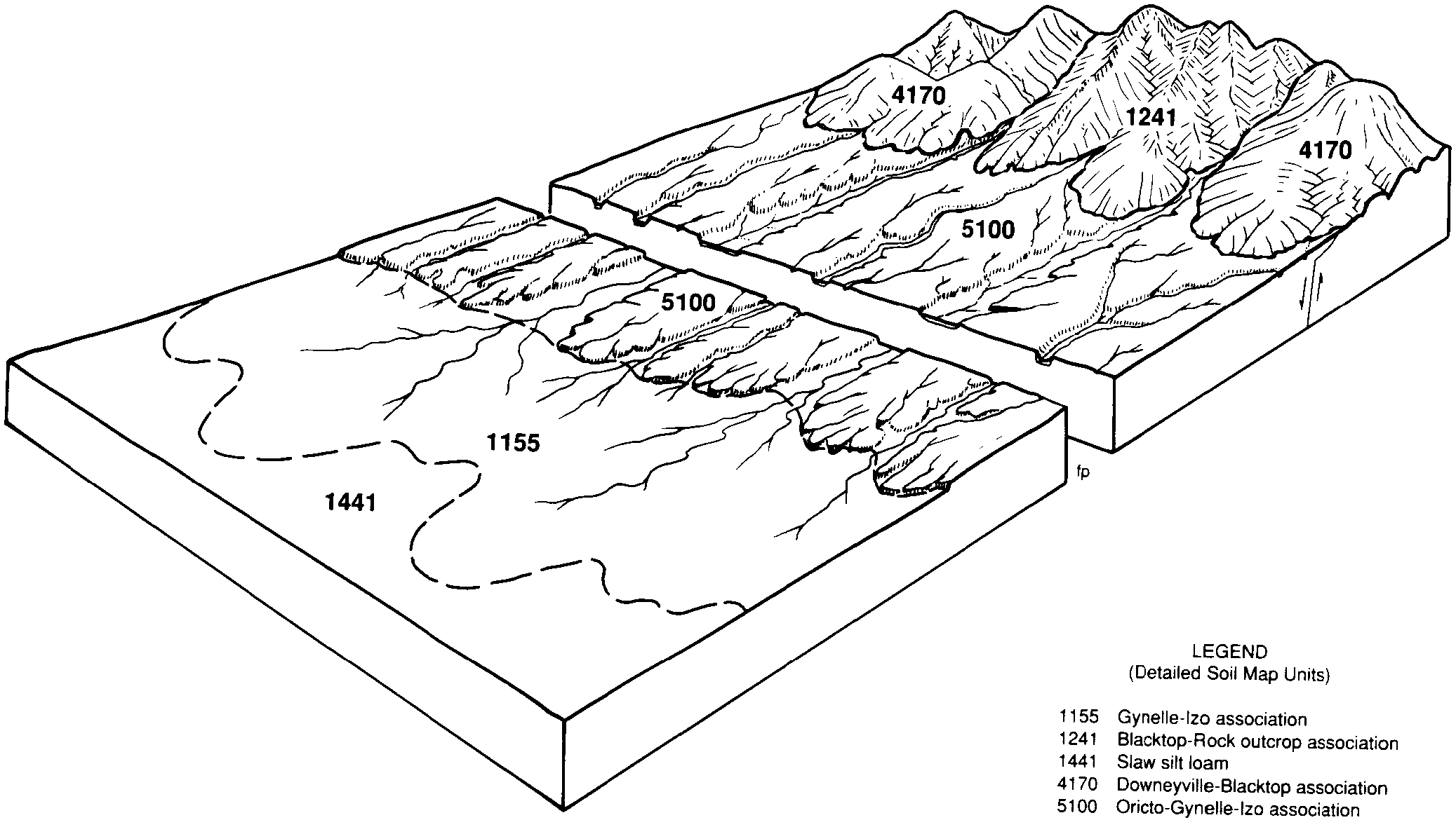
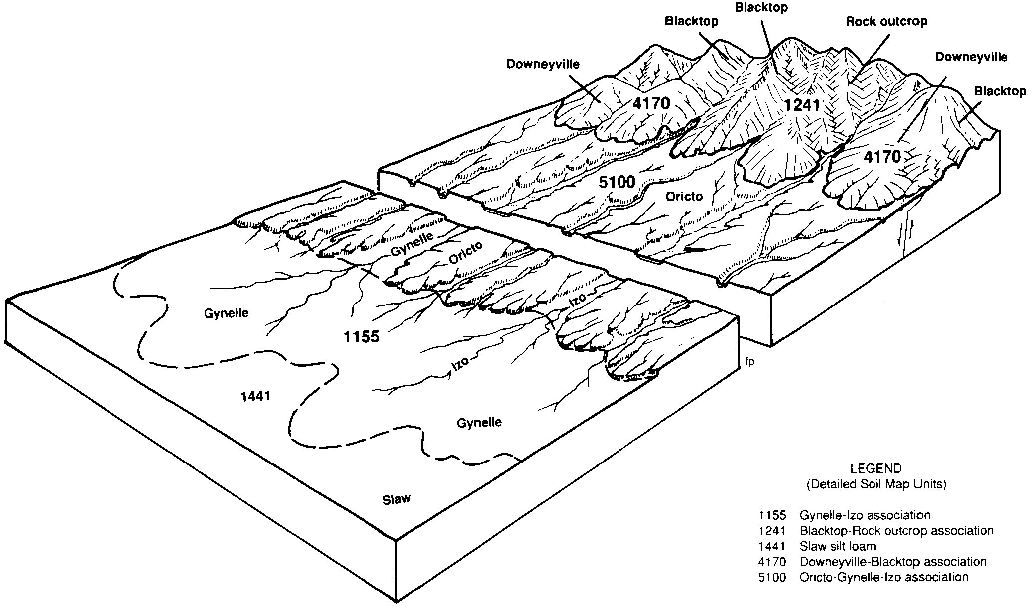
Downeyville-Blacktop-Rock outcrop association | 1011 | 14733 | 476379 | 2s21d | nv770 | 1995 | 1:24000 |
Downeyville-Stewval-Blacktop association | 1010 | 8119 | 476378 | 2s219 | nv770 | 1995 | 1:24000 |
Downeyville, moist-Downeyville-Gabbvally association | 1013 | 5628 | 476381 | 2s22h | nv770 | 1995 | 1:24000 |
Downeyville, moist-Downeyville-Blacktop association | 1012 | 2420 | 476380 | 2s22q | nv770 | 1995 | 1:24000 |
Nemico-Lapon-Downeyville association | 7006 | 562 | 2229614 | 2dv31 | nv770 | 1995 | 1:24000 |
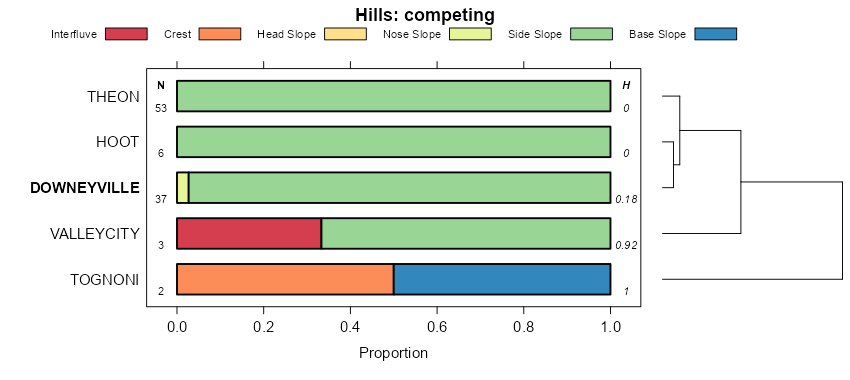
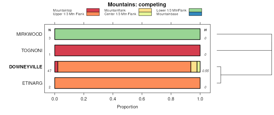
Downeyville-Blacktop-Rock outcrop association | 1240 | 83001 | 476739 | 2s21d | nv774 | 1985 | 1:24000 |
Downeyville, moist-Downeyville-Gabbvally association | 4176 | 25408 | 476958 | 2s22h | nv774 | 1985 | 1:24000 |
Downeyville, moist-Downeyville-Blacktop association | 4175 | 22250 | 476957 | 2s22q | nv774 | 1985 | 1:24000 |
Loomer-Rowel-Downeyville association | 3140 | 6175 | 476905 | j081 | nv774 | 1985 | 1:24000 |
Downeyville-Stewval-Rock outcrop association | 4173 | 5357 | 476955 | j09n | nv774 | 1985 | 1:24000 |
Downeyville-Stewval-Blacktop association | 4178 | 5092 | 476960 | 2s219 | nv774 | 1985 | 1:24000 |
Belted-Downeyville association | 1320 | 4805 | 476750 | j031 | nv774 | 1985 | 1:24000 |
Downeyville-Stewval-Mirkwood association | 4174 | 3270 | 476956 | j09p | nv774 | 1985 | 1:24000 |
Candelaria-Downeyville-Annaw association | 4188 | 2177 | 476968 | j0b2 | nv774 | 1985 | 1:24000 |
Loomer-Downeyville-Rock outcrop association | 3142 | 1903 | 476907 | j083 | nv774 | 1985 | 1:24000 |
Downeyville-Mirkwood-Nemico association | 4177 | 1520 | 476959 | j09s | nv774 | 1985 | 1:24000 |
Downeyville-Theon-Nemico association | 7074 | 1406 | 2425589 | 2mf0t | nv774 | 1985 | 1:24000 |
Downeyville-Hawsley association | 4171 | 734 | 476954 | j09m | nv774 | 1985 | 1:24000 |
Stewval-Downeyville-Rock outcrop association | 1227 | 28102 | 480710 | 2s22w | nv781 | 1994 | 1:24000 |
Downeyville-Rock outcrop complex, 15 to 50 percent slopes | 1830 | 10747 | 480818 | 2s21f | nv781 | 1994 | 1:24000 |
Downeyville-Stewval-Blacktop association | 1833 | 10050 | 480819 | 2s219 | nv781 | 1994 | 1:24000 |
Downeyville-Blacktop-Rock outcrop association | 1891 | 9825 | 480827 | 2s21d | nv781 | 1994 | 1:24000 |
Berzatic-Downeyville-Pintwater association | 1263 | 9650 | 480724 | j477 | nv781 | 1994 | 1:24000 |
Stewval-Downeyville-Gabbvally association | 1222 | 4578 | 480707 | j46p | nv781 | 1994 | 1:24000 |
Pintwater-Stumble-Downeyville association | 1955 | 4430 | 480838 | j4bx | nv781 | 1994 | 1:24000 |
Downeyville-Goldyke-Blacktop association | 1835 | 3355 | 480821 | j4bc | nv781 | 1994 | 1:24000 |
Downeyville-Silverbow-Rock outcrop association | 2040 | 235 | 480841 | 2s22j | nv781 | 1994 | 1:24000 |
Downeyville-Blacktop association | 1834 | 1 | 480820 | j4bb | nv781 | 1994 | 1:24000 |
Downeyville-Stewval association | 3831 | 28792 | 481063 | j4l5 | nv783 | 1991 | 1:24000 |
Downeyville-Rock outcrop complex, 15 to 50 percent slopes | 3830 | 18325 | 481062 | 2s21f | nv783 | 1991 | 1:24000 |
Downeyville-Tokoper association | 3832 | 3740 | 481064 | j4l6 | nv783 | 1991 | 1:24000 |
Downeyville-Pintwater-Upspring association | 2496 | 12597 | 469169 | hr6h | nv785 | 1995 | 1:24000 |
Gabbvally-Downeyville association | 2734 | 3716 | 469202 | hr7k | nv785 | 1995 | 1:24000 |
Tokoper-Downeyville-Pintwater association | 2251 | 3285 | 469118 | hr4v | nv785 | 1995 | 1:24000 |
Gabbvally-Tognoni-Downeyville association | 2732 | 2653 | 469201 | hr7j | nv785 | 1995 | 1:24000 |
Downeyville-Blacktop-Tokoper association | 2491 | 2591 | 469164 | hr6b | nv785 | 1995 | 1:24000 |
Tokoper-Downeyville-Espint association | 2254 | 2503 | 469121 | hr4y | nv785 | 1995 | 1:24000 |
Downeyville-Unsel-Tokoper association | 2760 | 1899 | 469208 | hr7r | nv785 | 1995 | 1:24000 |
Gabbvally-Downeyville-Vindicator association | 2731 | 1845 | 469200 | hr7h | nv785 | 1995 | 1:24000 |
Downeyville-Vindicator-Stewval association | 2494 | 1741 | 469167 | hr6f | nv785 | 1995 | 1:24000 |
Downeyville-Advokay-Pintwater association | 2640 | 1001 | 469185 | hr70 | nv785 | 1995 | 1:24000 |
Blacktop-Downeyville-Tognoni association | 2741 | 890 | 469206 | hr7p | nv785 | 1995 | 1:24000 |
Downeyville-Tognoni-Stonell association | 2493 | 588 | 469166 | hr6d | nv785 | 1995 | 1:24000 |
Downeyville-Silverbow-Rock outcrop association | 2492 | 525 | 469165 | 2s22j | nv785 | 1995 | 1:24000 |
Downeyville-Gabbvally association | 2495 | 143 | 469168 | 2s22g | nv785 | 1995 | 1:24000 |
Downeyville-Blacktop-Rock outcrop association | 362 | 61103 | 485015 | 2s21d | nv796 | 1984 | 1:63360 |
Stewval-Downeyville-Rock outcrop association | 230 | 36472 | 484957 | 2s22w | nv796 | 1984 | 1:63360 |
Downeyville-Silverbow-Rock outcrop association | 363 | 28760 | 485016 | 2s22j | nv796 | 1984 | 1:63360 |
Downeyville-Gabbvally association | 367 | 26521 | 485019 | 2s22g | nv796 | 1984 | 1:63360 |
Downeyville-Pintwater-Rock outcrop association | 360 | 21224 | 485013 | 2v41c | nv796 | 1984 | 1:63360 |
Tokoper-Downeyville-Pintwater association | 715 | 16671 | 485135 | j8tj | nv796 | 1984 | 1:63360 |
Vindicator-Downeyville-Blacktop association | 593 | 8270 | 485090 | j8s2 | nv796 | 1984 | 1:63360 |
Gabbvally-Downeyville-Rock outcrop association | 658 | 6992 | 485113 | j8st | nv796 | 1984 | 1:63360 |
Downeyville-Advokay-Pintwater association | 369 | 5382 | 485021 | 2whm5 | nv796 | 1984 | 1:63360 |
Downeyville-Pintwater-Upspring association | 368 | 5010 | 485020 | j8pt | nv796 | 1984 | 1:63360 |
Stewval-Downeyville, moist-Rock outcrop association | 236 | 4724 | 484963 | j8mz | nv796 | 1984 | 1:63360 |
Downeyville-Gabbvally-Malmesa association | 365 | 3746 | 485018 | j8pr | nv796 | 1984 | 1:63360 |
Pintwater-Blacktop-Downeyville association | 414 | 3040 | 485034 | j8q8 | nv796 | 1984 | 1:63360 |
Downeyville-Vindicator-Advokay association | 364 | 2939 | 485017 | j8pq | nv796 | 1984 | 1:63360 |
Downeyville-Pumel-Rock outcrop association | 361 | 2532 | 485014 | j8pm | nv796 | 1984 | 1:63360 |
Tognoni-Blacktop-Downeyville association | 281 | 2163 | 484980 | j8nj | nv796 | 1984 | 1:63360 |
Terlco-Advokay-Downeyville association | 191 | 1240 | 484943 | j8mb | nv796 | 1984 | 1:63360 |
Ardivey-Downeyville-Leo association | 477 | 1151 | 485064 | j8r7 | nv796 | 1984 | 1:63360 |
Downeyville-Blacktop-Rock outcrop association | 251 | 4333 | 477621 | 2s21d | nv799 | 1991 | 1:24000 |
Downeyville, moist-Downeyville-Gabbvally association | 250 | 2684 | 477620 | 2s22h | nv799 | 1991 | 1:24000 |
Downeyville, moist-Gabbvally association | 252 | 1151 | 477622 | j105 | nv799 | 1991 | 1:24000 |
Downeyville, moist-Blacktop association | 253 | 1070 | 477623 | j106 | nv799 | 1991 | 1:24000 |