| Dowling clay, 0 to 1 percent slopes, frequently flooded, tensas | DZ | 15340 | 3121699 | 2zfyj | la009 | 1981 | 1:24000 |
Dowling clay, 0 to 1 percent slopes, frequently flooded, deltaic plain | DX | 185 | 3121698 | 2zfyk | la009 | 1981 | 1:24000 |
Dowling clay, 0 to 1 percent slopes, frequently flooded, tensas | DZ | 5553 | 1722389 | 2zfyj | la025 | 1983 | 1:24000 |
Dowling clay, 0 to 1 percent slopes, frequently flooded, tensas | DZ | 10803 | 3219831 | 2zfyj | la029 | 1983 | 1:24000 |
Dowling soils, 0 to 1 percent slopes, frequently flooded | DW | 520 | 3219832 | 2tpnj | la029 | 1983 | 1:24000 |
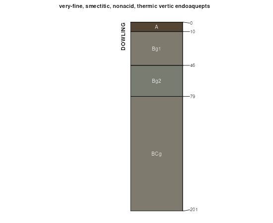
Dowling soils, 0 to 1 percent slopes, frequently flooded | DW | 47809 | 1451368 | 2tpnj | la047 | 1975 | 1:24000 |
Sharkey and Fausse soils | SY | 15626 | 808498 | w49l | la047 | 1975 | 1:24000 |
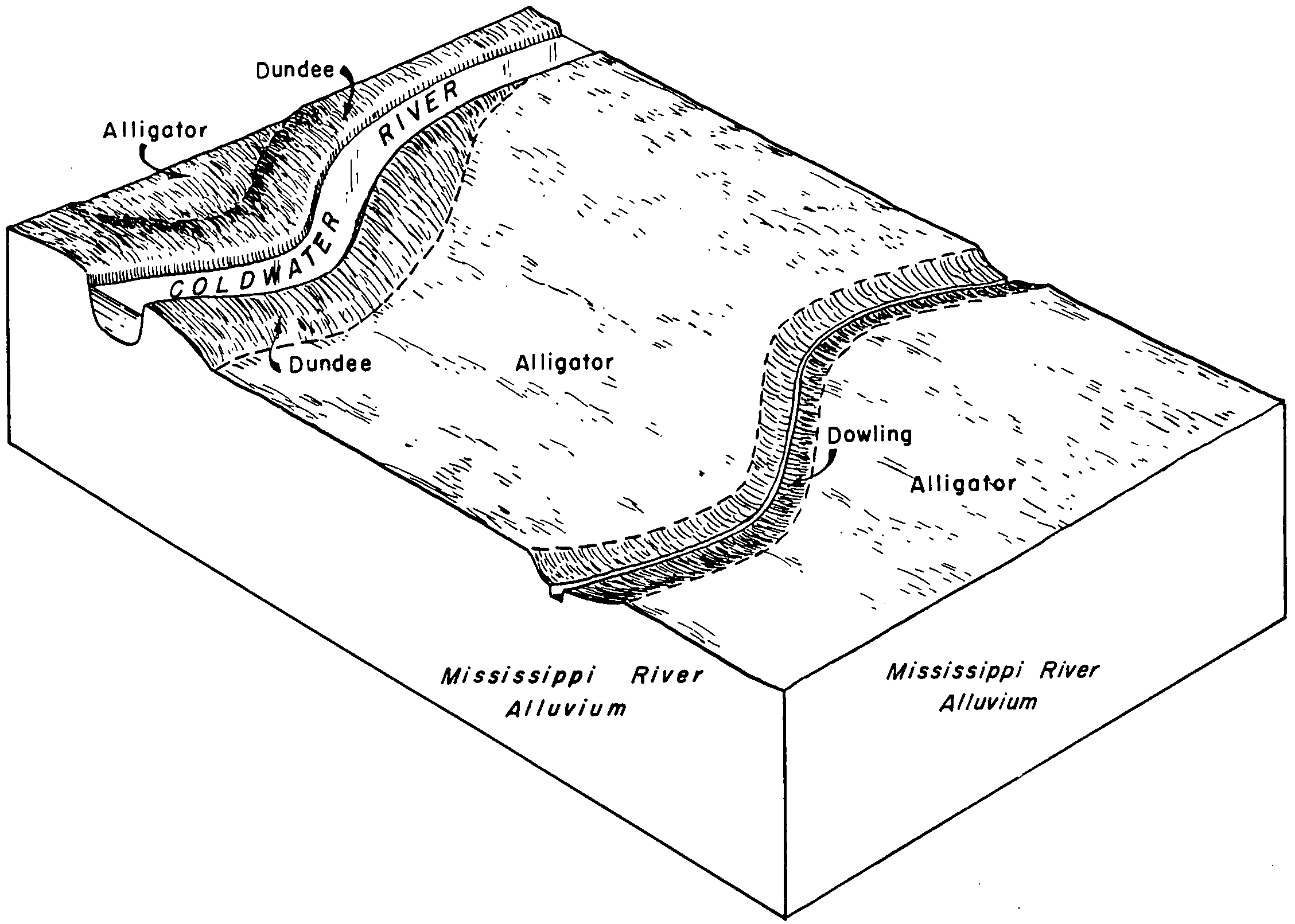
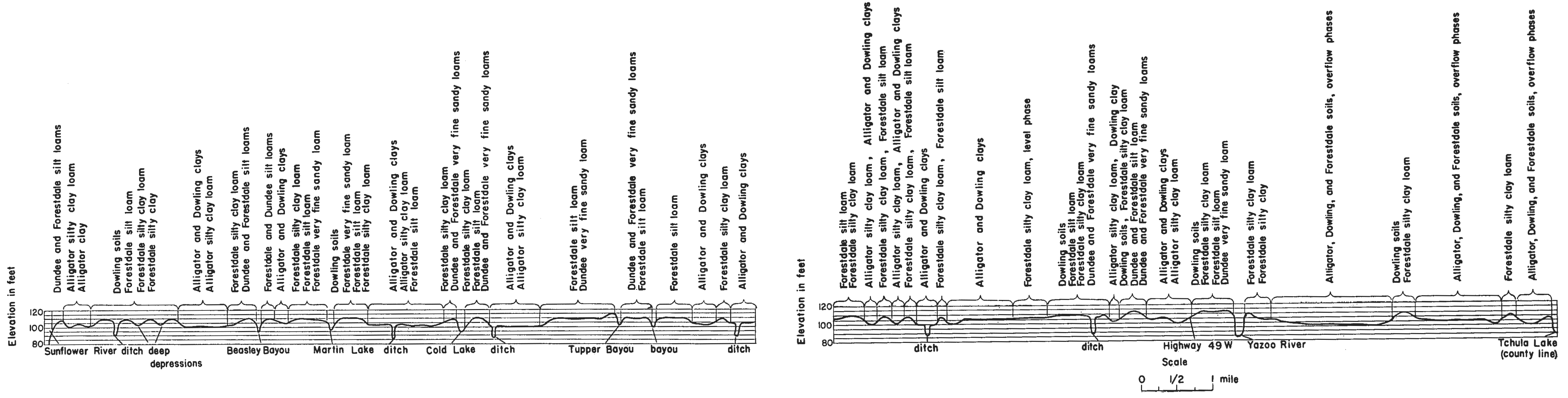
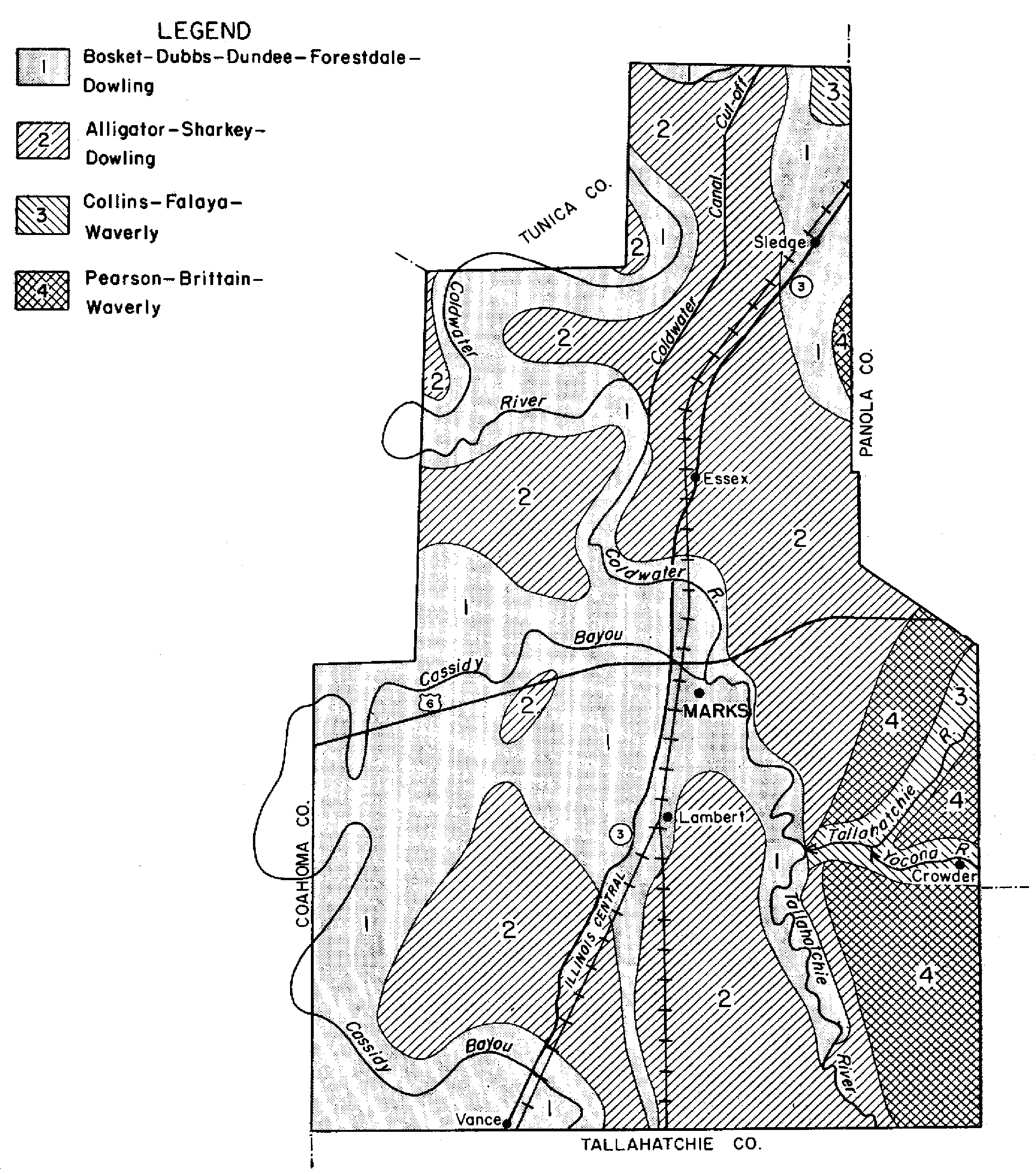
Dowling association, frequently flooded | DO | 14451 | 1451367 | 1kq89 | la047 | 1975 | 1:24000 |
Dowling clay, 0 to 1 percent slopes, frequently flooded, deltaic plain | DX | 2237 | 808635 | 2zfyk | la055 | 1976 | 1:24000 |
Dowling clay, 0 to 1 percent slopes, frequently flooded, tensas | DZ | 7116 | 3121700 | 2zfyj | la059 | 1986 | 1:24000 |
Dowling clay, 0 to 1 percent slopes, frequently flooded, deltaic plain | DX | 5169 | 1678428 | 2zfyk | la077 | 1980 | 1:24000 |
Dowling soils, 0 to 1 percent slopes, frequently flooded | DW | 3798 | 1678429 | 2tpnj | la077 | 1980 | 1:24000 |
Dowling clay, 0 to 1 percent slopes, frequently flooded, deltaic plain | DX | 23051 | 823805 | 2zfyk | la097 | 1983 | 1:24000 |
Dowling soils, 0 to 1 percent slopes, frequently flooded | DW | 48789 | 1451686 | 2tpnj | la099 | 1974 | 1:24000 |
Dowling clay, 0 to 1 percent slopes, frequently flooded, deltaic plain | DX | 21828 | 3219835 | 2zfyk | la099 | 1974 | 1:24000 |
Dowling clay, 0 to 1 percent slopes, frequently flooded | DoA | 11092 | 577266 | mcph | la107 | 2001 | 1:24000 |
Sharkey-Dowling clays, 0 to 3 percent slopes | SsB | 10585 | 577265 | mcpg | la107 | 2001 | 1:24000 |
Dowling clay, frequently flooded | Fa | 555 | 1397380 | 1hx2s | la121 | 2004 | 1:24000 |
Dowling soils, 0 to 1 percent slopes, frequently flooded | DW | 7654 | 3219842 | 2tpnj | la125 | 2002 | 1:24000 |
Dowling clay, 0 to 1 percent slopes, frequently flooded, tensas | DZ | 241 | 3219841 | 2zfyj | la125 | 2002 | 1:24000 |
Dowling clay, 0 to 1 percent slopes, frequently flooded, deltaic plain | DX | 136 | 3219840 | 2zfyk | la125 | 2002 | 1:24000 |
Dowling clay (sharkey) | Dc | 71411 | 567484 | m1hy | ms011 | 1956 | 1:20000 |
Dowling soils, overwash phases (sharkey) | Dd | 23496 | 567485 | m1hz | ms011 | 1956 | 1:20000 |
Dowling clay (sharkey) | Da | 32569 | 567631 | m1np | ms027 | 1956 | 1:24000 |
Dowling soils (sharkey) | Db | 17856 | 567632 | m1nq | ms027 | 1956 | 1:24000 |
Dowling soils (sharkey) | Db | 2172 | 567733 | m1rz | ms033 | 1955 | 1:24000 |
Dowling clay (sharkey) | Da | 2009 | 567732 | m1ry | ms033 | 1955 | 1:24000 |
Dowling clay, frequently flooded | Do | 8167 | 2693430 | 2rv5w | ms051 | 1997 | 1:20000 |
Alligator, Tensas, and Dowling soils, frequently flooded | ATF | 4342 | 567943 | m1zr | ms051 | 1997 | 1:20000 |
Dowling clay (alligator) | Da | 21610 | 568005 | m21r | ms053 | 1956 | 1:20000 |
Alligator, Dowling, and Forestdale soils, frequently flooded (alligator, alligator, forestdale) | An | 18804 | 2693432 | 2rv64 | ms053 | 1956 | 1:20000 |
Alligator-Dowling clays, frequently flooded (alligator, alligator) | Am | 10628 | 2693442 | 2rv63 | ms053 | 1956 | 1:20000 |
Dowling soils (alligator) | Dc | 7926 | 568007 | m21t | ms053 | 1956 | 1:20000 |
Dowling clay, frequently flooded (alligator) | Db | 5754 | 2693438 | 2rv65 | ms053 | 1956 | 1:20000 |
Dowling soils, frequently flooded (alligator) | Dd | 1405 | 2693439 | 2rv66 | ms053 | 1956 | 1:20000 |
Sharkey and Dowling clays, frequently flooded (sharkey, sharkey) | Sr | 103806 | 2693448 | 2rv6g | ms055 | 1960 | 1:20000 |
Dowling clay, frequently flooded (sharkey) | Da | 16994 | 2693445 | 2rv6c | ms055 | 1960 | 1:20000 |
Dowling soils, occasionally flooded (sharkey) | Db | 777 | 2693446 | 2rv6d | ms055 | 1960 | 1:20000 |
Alligator, Tensas, and Dowling soils, frequently flooded | 7 | 19494 | 568120 | m25g | ms083 | 1997 | 1:24000 |
Dowling muck | 23 | 11600 | 568119 | m25f | ms083 | 1997 | 1:24000 |
Dowling clay and silty clay (sharkey) | Da | 47320 | 568375 | m2fp | ms119 | 1956 | 1:24000 |
Alligator and Dowling clays (sharkey) | Ae | 45716 | 568352 | m2dy | ms119 | 1956 | 1:24000 |
Sharkey, Alligator, and Dowling soils, frequently flooded (sharkey, alligator, sharkey) | Sr | 103146 | 2693475 | 2rp1v | ms125 | 1960 | 1:20000 |
Dowling clay, frequently flooded (sharkey) | Da | 9883 | 2693476 | 2rp1p | ms125 | 1960 | 1:20000 |
Dowling soils, occasionally flooded (sharkey) | Db | 815 | 2693477 | 2rp1q | ms125 | 1960 | 1:20000 |
Dowling clay (sharkey) | Db | 50658 | 568457 | m2jb | ms133 | 1956 | 1:20000 |
Dowling soils, overwash phases (sharkey) | Dc | 41489 | 568458 | m2jc | ms133 | 1956 | 1:20000 |
Alligator-Dowling association (alligator, alligator) | As | 3377 | 568558 | m2ml | ms137 | 1964 | 1:15840 |
Dowling clay (alligator) | Dc | 602 | 568566 | m2mv | ms137 | 1964 | 1:15840 |
Dowling clay, 0 to 1 percent slopes, ponded | 125 | 2656 | 1715964 | 1vllp | ms143 | 2006 | 1:24000 |
Sharkey, Tunica, and Dowling clays, frequently flooded (sharkey, tunica, sharkey) | SDT | 45252 | 2693462 | 2rp20 | ms149 | 1962 | 1:15840 |
Dowling clay, frequently flooded (sharkey) | Do | 8277 | 2693460 | 2rp1z | ms149 | 1962 | 1:15840 |
Dowling clay (sharkey), 0 to 2 percent slopes, occasionally flooded | Da | 48900 | 568742 | m2tj | ms151 | 1959 | 1:20000 |
Dowling soils (sharkey), 0 to 2 percent slopes, occasionally flooded | Db | 11141 | 568743 | m2tk | ms151 | 1959 | 1:20000 |
Dowling clay, submerged | 8 | 4698 | 571042 | m56q | ms157 | 2006 | 1:24000 |