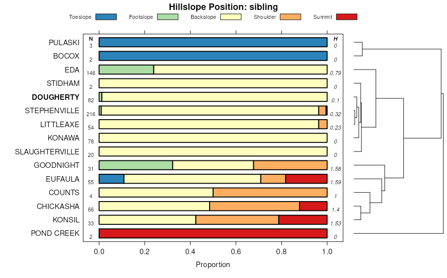
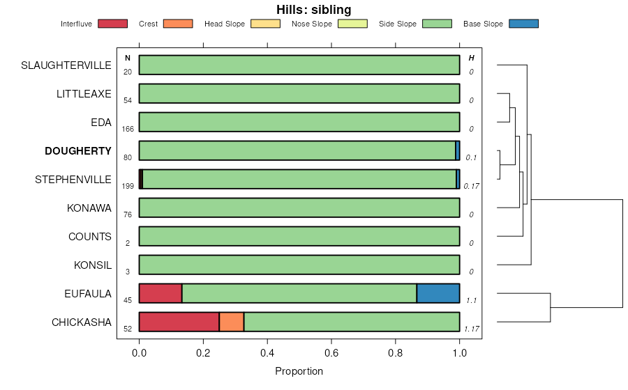
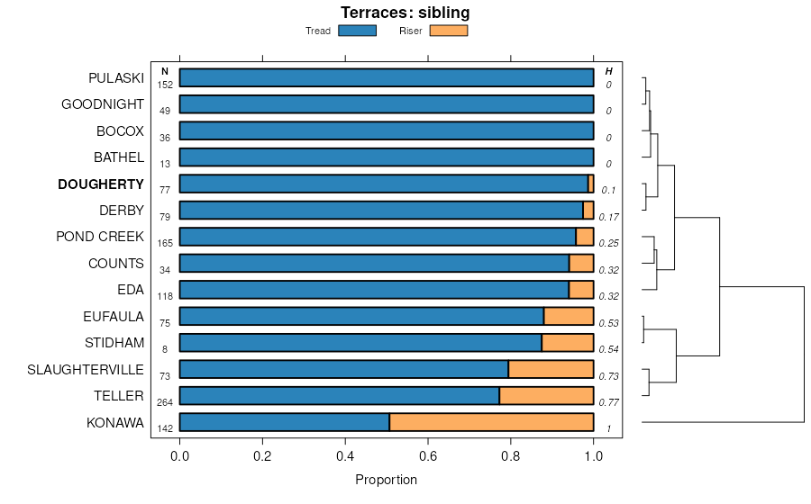
| Dougherty fine sand, 0 to 3 percent slopes | DoB | 4482 | 381421 | dswx | ok003 | 1971 | 1:24000 |
Dougherty-Eufaula complex, 3 to 8 percent slopes | DuD | 31083 | 381882 | 2tq7w | ok015 | 1967 | 1:24000 |
Dougherty-Konawa loamy fine sands association, 0 to 3 percent slopes | DoB | 11666 | 381881 | 30g72 | ok015 | 1967 | 1:24000 |
Dougherty-Konawa complex, 3 to 8 percent slopes | 11 | 779 | 382084 | dtl9 | ok027 | 1984 | 1:24000 |
Dougherty-Eufaula complex, 3 to 8 percent slopes | DoED | 232 | 1380055 | 2tq7w | ok031 | 1965 | 1:24000 |
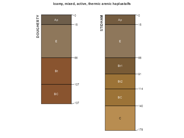
Dougherty and Stidham soils, 3 to 8 percent slopes | Dk | 2875 | 382282 | dtsp | ok037 | 1952 | 1:24000 |
Dougherty and Stidham soils, 0 to 3 percent slopes | Dl | 1310 | 382283 | dtsq | ok037 | 1952 | 1:24000 |
Dougherty-Eufaula complex, 8 to 20 percent slopes | DoEF | 251 | 2516364 | 1t7xb | ok037 | 1952 | 1:24000 |
Dougherty loamy fine sand, 3 to 8 percent slopes | DouD | 67 | 2516365 | 2tq7s | ok037 | 1952 | 1:24000 |
Dougherty-Eufaula complex, 3 to 8 percent slopes | 7 | 11609 | 382690 | 2tq7w | ok051 | 1975 | 1:24000 |
Dougherty fine sand, 0 to 3 percent slopes | 6 | 1041 | 382682 | dv6l | ok051 | 1975 | 1:24000 |
Dougherty loamy fine sand, 0 to 3 percent slopes | DoB | 5819 | 383224 | 2tq7r | ok067 | 1967 | 1:24000 |
Dougherty loamy fine sand, 3 to 8 percent slopes | DoC | 903 | 383225 | 2tq7s | ok067 | 1967 | 1:24000 |
Dougherty loamy fine sand, 0 to 3 percent slopes | 13 | 3763 | 383275 | dvtq | ok069 | 1976 | 1:24000 |
Dougherty-Eufaula complex, 3 to 8 percent slopes | DxC | 3069 | 383327 | 2tq7w | ok071 | 1965 | 1:24000 |
Dougherty-Eufaula complex, 0 to 3 percent slopes | DxB | 687 | 383326 | 2tq7x | ok071 | 1965 | 1:24000 |
Dougherty-Eufaula complex, 3 to 8 percent slopes | DeC | 21423 | 383390 | 2tq7w | ok073 | 1960 | 1:24000 |
Dougherty-Eufaula complex, 0 to 3 percent slopes | DeB | 20614 | 383389 | 2tq7x | ok073 | 1960 | 1:24000 |
Dougherty loamy fine sand, 3 to 8 percent slopes | DuD | 8595 | 383510 | 2tq7s | ok081 | 1966 | 1:24000 |
Eufaula-Dougherty complex, 5 to 12 percent slopes | EdE | 5347 | 383511 | dw2b | ok081 | 1966 | 1:24000 |
Dougherty loamy fine sand, 0 to 3 percent slopes | DouB | 5163 | 383610 | 2tq7r | ok083 | 1994 | 1:12000 |
Dougherty loamy fine sand, 3 to 8 percent slopes | DouD | 4838 | 383611 | 2tq7s | ok083 | 1994 | 1:12000 |
Dougherty and Konsil soils, 5 to 8 percent slopes | DoD | 23080 | 383708 | dw8p | ok085 | 1963 | 1:24000 |
Dougherty loamy fine sand, 0 to 3 percent slopes | DoB | 17637 | 383706 | dw8m | ok085 | 1963 | 1:24000 |
Dougherty and Konsil soils, 3 to 5 percent slopes | DoC | 5389 | 383707 | dw8n | ok085 | 1963 | 1:24000 |
Dougherty loamy fine sand, 0 to 3 percent slopes | 6 | 8077 | 383908 | dwh4 | ok095 | 1978 | 1:24000 |
Derby-Urban land-Dougherty complex, 0 to 15 percent slopes | DUDE | 2222 | 384282 | dww6 | ok109 | 1996 | 1:12000 |
Derby-Dougherty complex, 0 to 15 percent slopes | DeDE | 1703 | 384285 | dww9 | ok109 | 1996 | 1:12000 |
Dougherty loamy fine sand, 3 to 8 percent slopes | 20 | 10015 | 623415 | 2tq7s | ok113 | 1975 | 1:24000 |
Dougherty loamy fine sand, 0 to 3 percent slopes | 19 | 8463 | 623414 | 2tq7r | ok113 | 1975 | 1:24000 |
Eufaula-Dougherty complex, 0 to 3 percent slopes | 22 | 5170 | 623417 | nxq7 | ok113 | 1975 | 1:24000 |
Dougherty loamy fine sand, 3 to 8 percent slopes | DouD | 2176 | 1423155 | 2tq7s | ok117 | 2007 | 1:24000 |
Dougherty-Eufaula complex, 8 to 20 percent slopes | DoEF | 1418 | 1675901 | 1t7xb | ok117 | 2007 | 1:24000 |
Dougherty loamy fine sand, 0 to 3 percent slopes | DouB | 856 | 1423154 | 2tq7r | ok117 | 2007 | 1:24000 |
Dougherty loamy fine sand, 3 to 8 percent slopes | 15 | 4889 | 384510 | 2tq7s | ok119 | 1983 | 1:24000 |
Dougherty loamy fine sand, 0 to 3 percent slopes | 95 | 2433 | 384593 | 2tq7r | ok119 | 1983 | 1:24000 |
Dougherty-Eufaula complex, 8 to 20 percent slopes | DoEF | 2123 | 1907679 | 22131 | ok119 | 1983 | 1:24000 |
Dougherty-Eufaula loamy fine sands, 8 to 20 percent slopes | DrE | 2834 | 384616 | dx6z | ok123 | 1967 | 1:24000 |
Dougherty loamy fine sand, 3 to 8 percent slopes | DoD | 2020 | 384615 | 2tq7s | ok123 | 1967 | 1:24000 |
Dougherty loamy fine sand, 0 to 3 percent slopes | DoB | 1298 | 384614 | 2tq7r | ok123 | 1967 | 1:24000 |
Dougherty loamy fine sand, 3 to 8 percent slopes | 11 | 2343 | 384670 | 2tq7s | ok125 | 1975 | 1:24000 |
Dougherty loamy fine sand, 0 to 3 percent slopes | 10 | 818 | 384669 | 2tq7r | ok125 | 1975 | 1:24000 |
Eufaula-Dougherty complex, 5 to 15 percent slopes | 11 | 7101 | 384796 | dxds | ok133 | 1976 | 1:24000 |
Eufaula-Dougherty complex, 0 to 5 percent slopes | 10 | 1516 | 384795 | dxdr | ok133 | 1976 | 1:24000 |
Dougherty loamy fine sand, 3 to 8 percent slopes | 8 | 1268 | 384843 | 2tq7s | ok133 | 1976 | 1:24000 |
Dougherty and Konawa soils, 3 to 8 percent slopes | DoC | 4656 | 384858 | dxgs | ok137 | 1960 | 1:24000 |
Dougherty-Konawa loamy fine sands association, 0 to 3 percent slopes | DoB | 1464 | 384857 | 30g72 | ok137 | 1960 | 1:24000 |
Konawa and Dougherty soils, 1 to 5 percent slopes, eroded | DuB2 | 354 | 384859 | dxgt | ok137 | 1960 | 1:24000 |
Dougherty-Eufaula complex, 3 to 8 percent slopes | 23 | 982 | 385007 | 2tq7w | ok149 | 1976 | 1:24000 |
