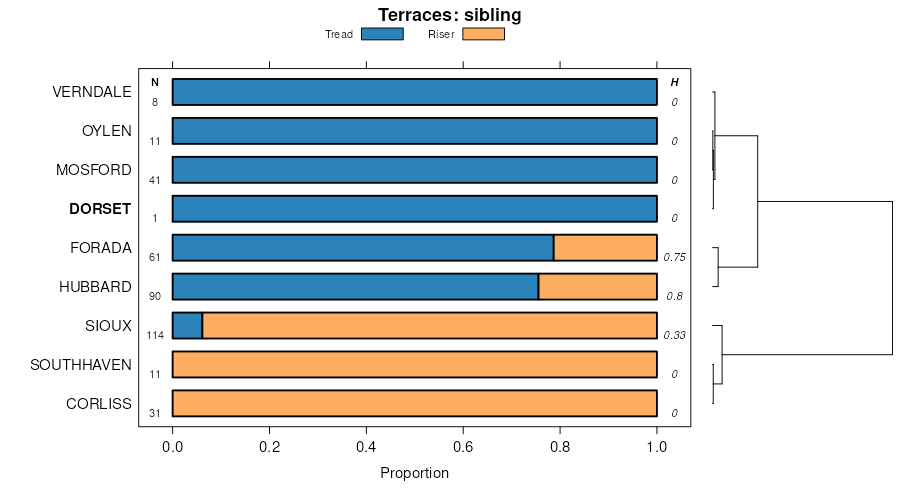
| Dorset sandy loam, 2 to 6 percent slopes | 406B | 8251 | 397525 | 2w0m3 | mn005 | 1994 | 1:20000 |
Dorset-Corliss complex, 1 to 6 percent slopes | 778B | 7206 | 397565 | 2w0m5 | mn005 | 1994 | 1:20000 |
Dorset-Corliss complex, 6 to 12 percent slopes | 778C | 5022 | 397566 | 2w0m6 | mn005 | 1994 | 1:20000 |
Dorset sandy loam, 0 to 2 percent slopes | 406A | 3581 | 397524 | 2w0m2 | mn005 | 1994 | 1:20000 |
Corliss-Dorset complex, 6 to 20 percent slopes | 1247D | 1123 | 397461 | 2w0m7 | mn005 | 1994 | 1:20000 |
Waukon-Dorset complex, 8 to 15 percent slopes | 1104C | 1013 | 397406 | fbjk | mn005 | 1994 | 1:20000 |
Waukon-Dorset complex, 1 to 8 percent slopes | 1104B | 585 | 397405 | fbjj | mn005 | 1994 | 1:20000 |
Dorset sandy loam, Mississippi River Valley, 0 to 2 percent slopes | D98A | 561 | 2732685 | 2sln9 | mn035 | 2009 | 1:24000 |
Dorset sandy loam, 2 to 6 percent slopes | DoB | 6587 | 397270 | 2w0m3 | mn041 | 1970 | 1:12000 |
Dorset sandy loam, thick solum, 2 to 6 percent slopes | DpB | 2113 | 397273 | fbd8 | mn041 | 1970 | 1:12000 |
Dorset sandy loam, 0 to 2 percent slopes | DoA | 1814 | 397269 | 2w0m2 | mn041 | 1970 | 1:12000 |
Nebish-Dorset complex, 2 to 6 percent slopes | NhB | 1371 | 397309 | fbff | mn041 | 1970 | 1:12000 |
Dorset sandy loam, thick solum, 0 to 2 percent slopes | DpA | 1148 | 397272 | fbd7 | mn041 | 1970 | 1:12000 |
Dorset sandy loam, thick solum, 6 to 12 percent slopes | DpC | 1119 | 397274 | fbd9 | mn041 | 1970 | 1:12000 |
Nebish-Dorset complex, 6 to 12 percent slopes | NhC | 947 | 397310 | fbfg | mn041 | 1970 | 1:12000 |
Dorset sandy loam, 6 to 12 percent slopes | DoC | 829 | 397271 | 2w0m4 | mn041 | 1970 | 1:12000 |
Urban land-Dorset complex, 0 to 8 percent slopes | D33B | 2887 | 435219 | glwb | mn053 | 2001 | 1:12000 |
Dorset sandy loam, 0 to 2 percent slopes | D4A | 1667 | 451646 | 2w0m2 | mn053 | 2001 | 1:12000 |
Dorset sandy loam, 2 to 6 percent slopes | D4B | 423 | 451645 | 2w0m3 | mn053 | 2001 | 1:12000 |
Dorset, bedrock substratum-Rock outcrop complex, 25 to 65 percent slopes | D37F | 223 | 435228 | glwm | mn053 | 2001 | 1:12000 |
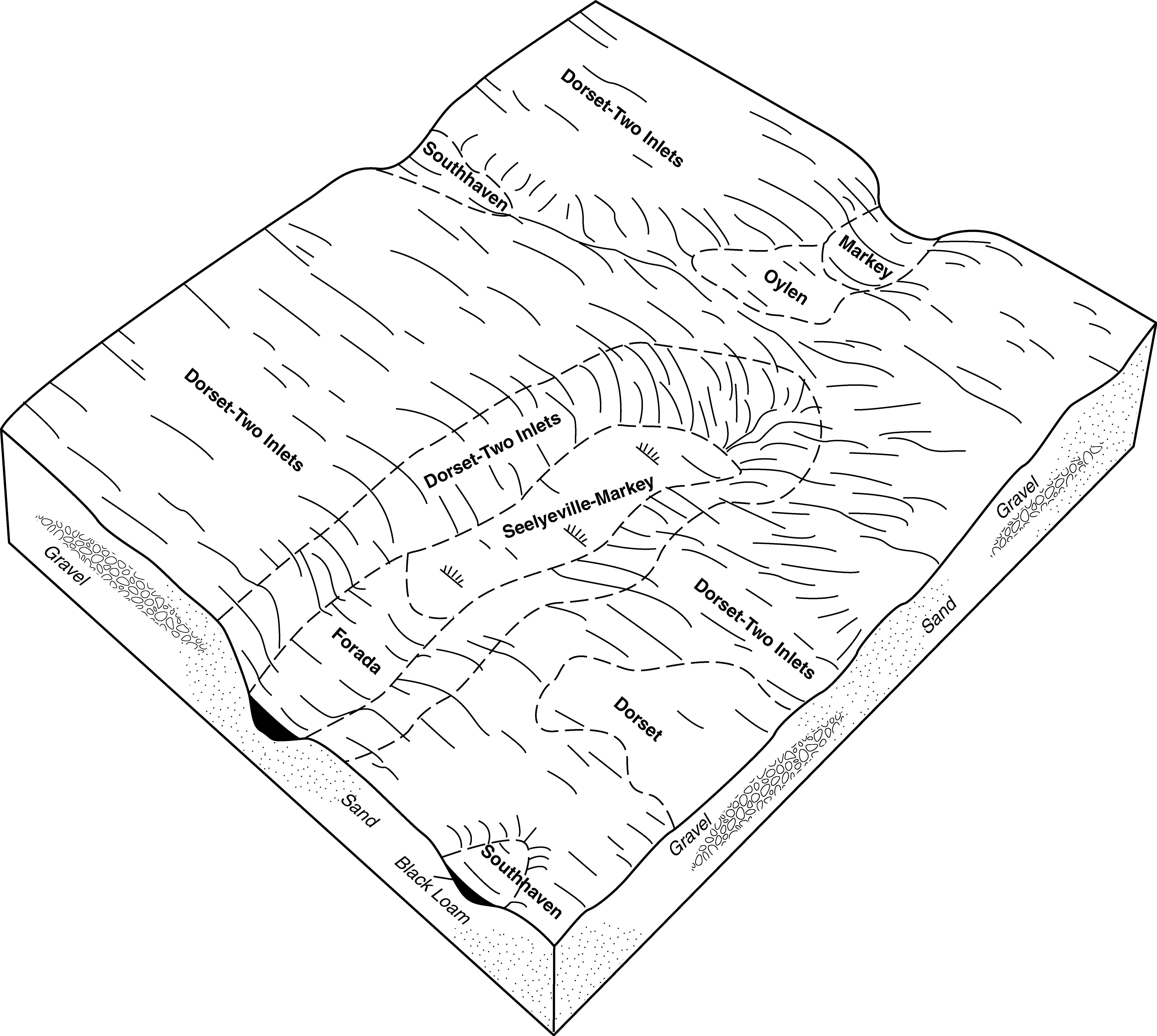
Dorset-Two Inlets complex, 2 to 6 percent slopes | D5B | 171 | 451644 | h4z5 | mn053 | 2001 | 1:12000 |
Dorset sandy loam, loamy substratum, 0 to 2 percent slopes | D27A | 153 | 448222 | h1ds | mn053 | 2001 | 1:12000 |
Dorset sandy loam, 6 to 12 percent slopes | D4C | 148 | 435213 | 2w0m4 | mn053 | 2001 | 1:12000 |
Urban land-Dorset complex, 8 to 18 percent slopes | D33C | 105 | 435220 | glwc | mn053 | 2001 | 1:12000 |
Dorset-Two Inlets complex, 6 to 12 percent slopes | D5C | 68 | 451643 | h4z4 | mn053 | 2001 | 1:12000 |
Dorset-Two Inlets complex, 12 to 18 percent slopes | D5D | 31 | 451642 | h4z3 | mn053 | 2001 | 1:12000 |
Dorset-Corliss complex, 1 to 6 percent slopes | 778B | 8251 | 436722 | 2w0m5 | mn057 | 1998 | 1:24000 |
Dorset-Corliss complex, 6 to 12 percent slopes | 778C | 2276 | 436723 | 2w0m6 | mn057 | 1998 | 1:24000 |
Corliss-Dorset complex, 6 to 20 percent slopes | 1247D | 224 | 436518 | 2w0m7 | mn057 | 1998 | 1:24000 |
Dorset sandy loam, 0 to 2 percent slopes | 406A | 207 | 436655 | 2w0m2 | mn057 | 1998 | 1:24000 |
Dorset-Corliss complex, 1 to 6 percent slopes | 778B | 43178 | 435946 | 2w0m5 | mn111 | 1996 | 1:20000 |
Dorset-Corliss complex, 6 to 12 percent slopes | 778C | 18305 | 435947 | 2w0m6 | mn111 | 1996 | 1:20000 |
Dorset sandy loam, 2 to 6 percent slopes | 406B | 10300 | 435754 | 2w0m3 | mn111 | 1996 | 1:20000 |
Dorset sandy loam, 0 to 2 percent slopes | 406A | 10175 | 435753 | 2w0m2 | mn111 | 1996 | 1:20000 |
Chapett-Dorset complex, 6 to 12 percent slopes, eroded | 1102C | 5152 | 435525 | gm66 | mn111 | 1996 | 1:20000 |
Corliss-Dorset complex, 6 to 20 percent slopes | 1247D | 4784 | 435581 | 2w0m7 | mn111 | 1996 | 1:20000 |
Waukon-Dorset complex, 6 to 12 percent slopes, eroded | 1104C | 3007 | 435528 | gm69 | mn111 | 1996 | 1:20000 |
Chapett-Dorset complex, 1 to 6 percent slopes | 1102B | 2354 | 435524 | gm65 | mn111 | 1996 | 1:20000 |
Waukon-Dorset complex, 12 to 20 percent slopes, eroded | 1104D | 2289 | 435529 | gm6b | mn111 | 1996 | 1:20000 |
Waukon-Dorset complex, 1 to 6 percent slopes | 1104B | 1279 | 435527 | gm68 | mn111 | 1996 | 1:20000 |
Dorset sandy loam, 2 to 6 percent slopes | 406B | 5965 | 428134 | 2w0m3 | mn145 | 1980 | 1:15840 |
Dorset sandy loam, 6 to 12 percent slopes | 406C | 1734 | 428135 | 2w0m4 | mn145 | 1980 | 1:15840 |
Dorset sandy loam, 15 to 25 percent slopes | 406E | 1182 | 428136 | gchv | mn145 | 1980 | 1:15840 |
Dorset sandy loam, 2 to 6 percent slopes | 406B | 10579 | 428539 | 2w0m3 | mn153 | 1985 | 1:20000 |
Kandota-Dorset sandy loams, 6 to 15 percent slopes | 800C | 5888 | 428573 | gcyy | mn153 | 1985 | 1:20000 |
Kandota-Dorset sandy loams, 15 to 40 percent slopes | 800E | 5158 | 428574 | gcyz | mn153 | 1985 | 1:20000 |
Kandota-Dorset sandy loams, 2 to 6 percent slopes | 800B | 3193 | 428572 | gcyx | mn153 | 1985 | 1:20000 |
Dorset-Sioux sandy loams, 6 to 15 percent slopes | 824C | 2503 | 428577 | gcz2 | mn153 | 1985 | 1:20000 |
Dorset-Sioux complex, 15 to 30 percent slopes | 824E | 1632 | 428578 | gcz3 | mn153 | 1985 | 1:20000 |
Dorset sandy loam, 6 to 12 percent slopes | 406C | 874 | 428540 | 2w0m4 | mn153 | 1985 | 1:20000 |
Dorset sandy loam, 0 to 2 percent slopes | 406A | 3530 | 428793 | 2w0m2 | mn159 | 1987 | 1:20000 |
Dorset sandy loam, 2 to 6 percent slopes | 406B | 1282 | 428794 | 2w0m3 | mn159 | 1987 | 1:20000 |
Dorset-Two Inlets complex, 2 to 6 percent slopes | 1377B | 15844 | 435080 | glqv | mn171 | 1998 | 1:12000 |
Dorset sandy loam, 0 to 2 percent slopes | 406 | 6347 | 433762 | 2w0m2 | mn171 | 1998 | 1:12000 |
Dorset-Two Inlets complex, 6 to 12 percent slopes | 1377C | 6347 | 435079 | glqt | mn171 | 1998 | 1:12000 |
Dorset-Almora complex, 1 to 4 percent slopes | 1379B | 2073 | 435075 | glqp | mn171 | 1998 | 1:12000 |
Dorset-Two Inlets complex, 12 to 20 percent slopes | 1377D | 1775 | 435078 | glqs | mn171 | 1998 | 1:12000 |
Dorset-Two Inlets complex, 20 to 35 percent slopes | 1377E | 1367 | 435077 | glqr | mn171 | 1998 | 1:12000 |


