| Hyde, Bayboro, and Muck soils | Hb | 71571 | 328148 | c0gf | al003 | 1961 | 1:20000 |
Swamp | Sw | 2224 | 328213 | c0jj | al003 | 1961 | 1:20000 |
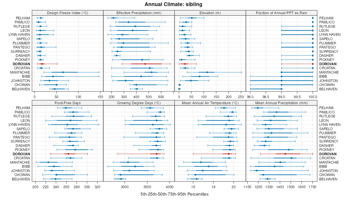
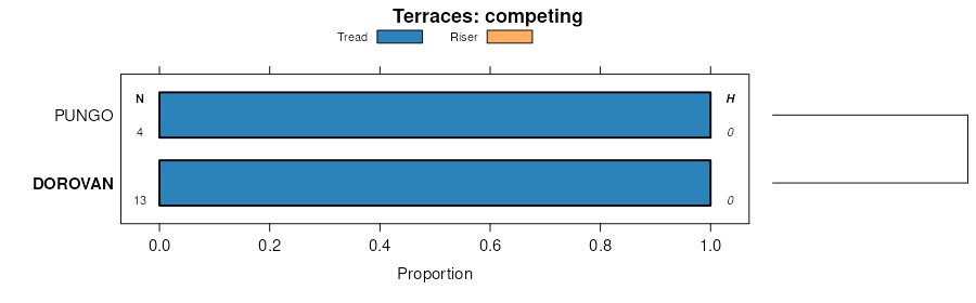
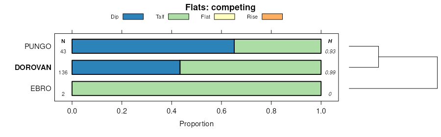
Dorovan muck, 0 to 1 percent slopes | DaA | 8300 | 328757 | c132 | al039 | 1985 | 1:20000 |
Dorovan muck | Do | 2756 | 329323 | c1pb | al053 | 1969 | 1:20000 |
Dorovan, Byars and Grady soils, ponded | DBA | 5756 | 607297 | ncy7 | al069 | 2002 | 1:24000 |
Johnston, Pamlico and Dorovan soils, 0 to 1 percent slopes, frequently flooded | JPA | 15860 | 2995021 | 2x5q8 | al097 | 2018 | 1:24000 |
Dorovan and Johnston soils, 0 to 1 percent slopes, frequently flooded | DJA | 7844 | 2995025 | 2x5s1 | al097 | 2018 | 1:24000 |
Chowan-Dorovan complex, 0 to 1 percent slopes, ponded | CdA | 774 | 2995050 | 2x5qq | al097 | 2018 | 1:24000 |
Dorovan muck, frequently flooded | 17 | 2095 | 1444875 | 1khhw | fl003 | 1991 | 1:20000 |
Pamlico-Dorovan complex | 22 | 28497 | 320810 | brtq | fl005 | 1982 | 1:20000 |
Ebro-Dorovan complex | 53 | 1464 | 320841 | brvq | fl005 | 1982 | 1:20000 |
Dorovan muck, frequently flooded | 29 | 5935 | 631640 | p68h | fl007 | 1988 | 1:15840 |
Dorovan muck | 43 | 1151 | 631648 | p68r | fl007 | 1988 | 1:15840 |
Dorovan-Pamlico-Rutlege association, depressional | 20 | 3026 | 1481002 | 1lq38 | fl013 | 1997 | 1:20000 |
Pamlico, loamy substratum-Dorovan complex | 46 | 3240 | 797468 | vrts | fl023 | 1981 | 1:24000 |
Dorovan muck | 21 | 2350 | 797441 | vrsx | fl023 | 1981 | 1:24000 |
Dorovan muck, depressional, 0 to 2 percent slopes | 87 | 1050 | 738899 | sswg | fl031 | 1996 | 1:24000 |
Dorovan muck and Fluvaquents, frequently flooded | 49 | 48120 | 1425355 | 1jv66 | fl033 | 1998 | 1:24000 |
Dorovan-Pamlico complex, depressional | 11 | 3198 | 1477062 | 1ll05 | fl037 | 1990 | 1:20000 |
Pickney, Dorovan, and Bibb soils, frequently flooded | 66 | 43487 | 1381605 | 1hcnx | fl039 | 2006 | 1:12000 |
Pamlico-Dorovan mucks, frequently flooded | 20 | 4075 | 321803 | bsvr | fl041 | 1989 | 1:20000 |
Dorovan-Croatan complex, depressional | 13 | 3076 | 1472734 | 1lfhk | fl045 | 1997 | 1:24000 |
Dorovan muck, depressional | 59 | 4480 | 1148857 | 17kgx | fl047 | 1995 | 1:24000 |
Dorovan-Pamlico association | 16 | 7290 | 1424918 | 1jtr3 | fl063 | 1977 | 1:20000 |
Pamlico-Dorovan mucks | 30 | 13150 | 700491 | rhxh | fl065 | 1984 | 1:20000 |
Pamlico and Dorovan soils, depressional | 11 | 41600 | 886564 | yrjv | fl067 | 1993 | 1:24000 |
Pamlico and Dorovan soils, frequently flooded | 10 | 400 | 886563 | yrjt | fl067 | 1993 | 1:24000 |
Dorovan mucky peat | 9 | 29015 | 1454468 | 1kthb | fl073 | 1989 | 1:20000 |
Pamlico-Dorovan complex | 38 | 3730 | 1454447 | 1ktgn | fl073 | 1989 | 1:20000 |
Pickney, Dorovan, and Bibb soils, frequently flooded | 65 | 14625 | 322756 | btvh | fl077 | 2004 | 1:24000 |
Dorovan-Pamlico complex, depressional | 13 | 1215 | 322699 | btsn | fl077 | 2004 | 1:24000 |
Dorovan and Pamlico soils, depressional | 74 | 80020 | 1380340 | 1hbc3 | fl079 | 1988 | 1:15840 |
Dorovan muck, frequently flooded | 6 | 35330 | 1444688 | 1kh9v | fl091 | 1989 | 1:20000 |
Dorovan-Pamlico association | 7 | 17120 | 823754 | wn5q | fl113 | 1978 | 1:20000 |
Dorovan and Pamlico soils, depressional | 30 | 58860 | 1425224 | 1jv1z | fl123 | 1998 | 1:24000 |
Dorovan muck | 43 | 3610 | 1414607 | 1jh0h | fl125 | 1989 | 1:15840 |
Dorovan muck, frequently flooded | 29 | 1580 | 1414594 | 1jh02 | fl125 | 1989 | 1:15840 |
Croatan-Dorovan mucks | 16 | 60090 | 1399042 | 1hytd | fl129 | 1988 | 1:24000 |
Dorovan-Pamlico association, frequently flooded | 8 | 41510 | 324047 | bw64 | fl131 | 1985 | 1:20000 |
Dorovan muck | Do | 3849 | 640578 | phkt | fl609 | 1968 | 1:24000 |
Dasher-Dorovan-Croatan association, ponded, 0 to 1 percent slopes | DDA | 139330 | 2408352 | 2sxqy | ga299 | 2008 | 1:24000 |
Dasher-Dorovan-Croatan association, ponded, 0 to 1 percent slopes | DDA | 156705 | 2686761 | 2sxqy | ga611 | 2012 | 1:24000 |
Dasher-Dorovan-Croatan association, ponded, 0 to 1 percent slopes | DDA | 24003 | 2686803 | 2sxqy | ga626 | 2013 | 1:24000 |
Pamlico-Dorovan association (croatan-dorovan) | PD | 10548 | 332228 | c4q1 | ms035 | 1976 | 1:20000 |
Dorovan-Johnston association | Dh | 32916 | 332260 | c4r2 | ms039 | 1967 | 1:20000 |
Dorovan and Johnston soils, 0 to 1 percent slopes, frequently flooded | DJA | 3501 | 2642178 | 2x5s1 | ms041 | 2012 | 1:24000 |
Dorovan muck | Do | 166 | 332620 | c53p | ms061 | 1974 | 1:20000 |
Dorovan and Pamlico mucks (dorovan and croatan) | Dp | 5401 | 332850 | c5c3 | ms073 | 1969 | 1:20000 |
Dorovan-Croatan association, frequently flooded | DC | 2639 | 333117 | c5mq | ms091 | 1983 | 1:20000 |
Dorovan-Croatan association | DC | 17531 | 333537 | c628 | ms109 | 1980 | 1:20000 |
Dorovan and Croatan soils, ponded | DO | 4144 | 333602 | c64c | ms111 | 1997 | 1:20000 |
Dorovan mucky peat, frequently flooded | Do | 8167 | 111569 | 3r30 | nc013 | 1986 | 1:24000 |
Dorovan mucky peat, frequently flooded | Dk | 30375 | 111423 | 3qy9 | nc015 | 1984 | 1:24000 |
Dorovan muck, frequently flooded | DO | 8905 | 115480 | 3w55 | nc017 | 1983 | 1:24000 |
Dorovan muck | DO | 14116 | 115536 | 3w6z | nc019 | 1983 | 1:24000 |
Dorovan muck, 0 to 2 percent slopes, frequently flooded | DoA | 27138 | 111783 | 2v9nl | nc029 | 1988 | 1:24000 |
Dorovan muck, 0 to 2 percent slopes, frequently flooded | DO | 1741 | 115588 | 2v9nl | nc031 | 1984 | 1:24000 |
Dorovan muck, 0 to 2 percent slopes, frequently flooded | DO | 6908 | 811390 | 2v9nl | nc041 | 1982 | 1:24000 |
Dorovan muck, frequently flooded | Do | 24180 | 115640 | 3wbb | nc047 | 1986 | 1:24000 |
Dorovan muck | DO | 8069 | 115742 | 3wfm | nc049 | 1984 | 1:24000 |
Dorovan mucky peat | Do | 11363 | 112114 | 3rnl | nc053 | 1980 | 1:20000 |
Dorovan mucky peat, 0 to 2 percent slopes, frequently flooded | DoA | 18576 | 115934 | 3wmt | nc073 | 1990 | 1:24000 |
Dorovan soils | DO | 16008 | 113161 | 3src | nc091 | 1981 | 1:24000 |
Dorovan muck, 0 to 2 percent slopes, frequently flooded | DoA | 4820 | 113286 | 2v9nl | nc095 | 1996 | 1:24000 |
Dorovan muck, frequently flooded | Do | 3775 | 111128 | 3qms | nc117 | 1985 | 1:24000 |
Dorovan soils | DO | 9568 | 116037 | 3wr4 | nc129 | 1974 | 1:15840 |
Dorovan muck | Da | 4515 | 116076 | 3wsd | nc133 | 1984 | 1:24000 |
Dorovan muck, 0 to 2 percent slopes, frequently flooded | DoA | 7762 | 1722266 | 2v9nl | nc139 | 2006 | 1:24000 |
Dorovan muck, frequently flooded | Do | 11379 | 116163 | 3ww6 | nc141 | 1986 | 1:24000 |
Dorovan muck, 0 to 2 percent slopes, frequently flooded | DO | 6123 | 811427 | 2v9nl | nc143 | 1982 | 1:24000 |
Dorovan muck, 0 to 2 percent slopes, frequently flooded | Do | 23600 | 115252 | 2v9nl | nc177 | 1985 | 1:24000 |
Dorovan muck, 0 to 2 percent slopes, frequently flooded | Do | 17649 | 116206 | 2v9nl | nc187 | 1979 | 1:24000 |
Dorovan and Ponzer soils, 0 to 2 percent slopes, frequently flooded | DpA | 1270 | 618873 | nrzn | sc031 | 1998 | 1:24000 |
Dorovan muck | Do | 12 | 2394339 | 2lchr | sc057 | 1967 | 1:20000 |
Dorovan silty clay loam, overwash, 0 to 2 percent slopes, frequently flooded | DaA | 804 | 1606537 | 1qxqs | sc061 | 2005 | 1:24000 |
Dorovan muck | Dn | 1947 | 131090 | 4ddq | sc079 | 1976 | 1:20000 |
Dorovan muck | Do | 5998 | 130190 | 4cgp | sc610 | 1985 | 1:20000 |
Dorovan muck, frequently flooded | Da | 1756 | 131338 | 4dnq | sc696 | 1988 | 1:15840 |
Dorovan muck, 0 to 2 percent slopes, frequently flooded | 12A | 2847 | 705271 | rnwp | va175 | 1996 | 1:24000 |
Dorovan-Belhaven complex, 0 to 1 percent slopes, frequently flooded | 18 | 14643 | 1445005 | 1khn2 | va550 | 2004 | 1:12000 |
Dorovan mucky peat | 12 | 8830 | 120887 | 41sl | va810 | 1982 | 1:15840 |