Official Series Description


Lab Data Summary

Aggregate lab data for the DONAVAN soil series. This aggregation is based on all pedons with a current taxon name of DONAVAN, and applied along 1-cm thick depth slices. Solid lines are the slice-wise median, bounded on either side by the interval defined by the slice-wise 5th and 95th percentiles. The median is the value that splits the data in half. Five percent of the data are less than the 5th percentile, and five percent of the data are greater than the 95th percentile. Values along the right hand side y-axis describe the proportion of pedon data that contribute to aggregate values at this depth. For example, a value of "90%" at 25cm means that 90% of the pedons correlated to DONAVAN were used in the calculation. Source: KSSL snapshot . Methods used to assemble the KSSL snapshot used by SoilWeb / SDE

Click the image to view it full size.

Pedons used in the lab summary:

MLRALab IDPedon IDTaxonnameCINSSL / NASIS ReportsLink To SoilWeb GMap
43A84P017383WA047008Donavan7Primary | Supplementary | Taxonomy | Pedon | Water Retention | Correlation | Andic Soil Properties48.2333336,-118.9666672

Water Balance

Monthly water balance estimated using a leaky-bucket style model for the DONAVAN soil series. Monthly precipitation (PPT) and potential evapotranspiration (PET) have been estimated from the 50th percentile of gridded values (PRISM 1981-2010) overlapping with the extent of SSURGO map units containing each series as a major component. Monthly PET values were estimated using the method of Thornthwaite (1948). These (and other) climatic parameters are calculated with each SSURGO refresh and provided by the fetchOSD function of the soilDB package. Representative water storage values (“AWC” in the figures) were derived from SSURGO by taking the 50th percentile of profile-total water storage (sum[awc_r * horizon thickness]) for each soil series. Note that this representation of “water storage” is based on the average ability of most plants to extract soil water between 15 bar (“permanent wilting point”) and 1/3 bar (“field capacity”) matric potential. Soil moisture state can be roughly interpreted as “dry” when storage is depleted, “moist” when storage is between 0mm and AWC, and “wet” when there is a surplus. Clearly there are a lot of assumptions baked into this kind of monthly water balance. This is still a work in progress.

Click the image to view it full size.


Click the image to view it full size.

Sibling Summary

Siblings are those soil series that occur together in map units, in this case with the DONAVAN series. Sketches are arranged according to their subgroup-level taxonomic structure. Source: SSURGO snapshot , parsed OSD records and snapshot of SC database .

Click the image to view it full size.

Select annual climate data summaries for the DONAVAN series and siblings. Series are sorted according to hierarchical clustering of median values. Source: SSURGO map unit geometry and 1981-2010, 800m PRISM data .

Click the image to view it full size.

Geomorphic description summaries for the DONAVAN series and siblings. Series are sorted according to hierarchical clustering of proportions and relative hydrologic position within an idealized landform (e.g. top to bottom). Most soil series (SSURGO components) are associated with a hillslope position and one or more landform-specific positions: hills, mountain slopes, terraces, and/or flats. Proportions can be interpreted as an aggregate representation of geomorphic membership. The values printed to the left (number of component records) and right (Shannon entropy) of stacked bars can be used to judge the reliability of trends. Small Shannon entropy values suggest relatively consistent geomorphic association, while larger values suggest lack thereof. Source: SSURGO component records .

Click the image to view it full size.

Click the image to view it full size.

Click the image to view it full size.

Click the image to view it full size.

There are insufficient data to create the 3D flats position figure.

Competing Series

Soil series competing with DONAVAN share the same family level classification in Soil Taxonomy. Source: parsed OSD records and snapshot of the SC database .

Click the image to view it full size.

Select annual climate data summaries for the DONAVAN series and competing. Series are sorted according to hierarchical clustering of median values. Source: SSURGO map unit geometry and 1981-2010, 800m PRISM data .

Click the image to view it full size.

Geomorphic description summaries for the DONAVAN series and competing. Series are sorted according to hierarchical clustering of proportions and relative hydrologic position within an idealized landform (e.g. top to bottom). Proportions can be interpreted as an aggregate representation of geomorphic membership. Most soil series (SSURGO components) are associated with a hillslope position and one or more landform-specific positions: hills, mountain slopes, terraces, and/or flats. The values printed to the left (number of component records) and right (Shannon entropy) of stacked bars can be used to judge the reliability of trends. Shannon entropy values close to 0 represent soil series with relatively consistent geomorphic association, while values close to 1 suggest lack thereof. Source: SSURGO component records .

Click the image to view it full size.

Click the image to view it full size.

Click the image to view it full size.

Click the image to view it full size.

There are insufficient data to create the 3D flats position figure.

Soil series sharing subgroup-level classification with DONAVAN, arranged according to family differentiae. Hovering over a series name will print full classification and a small sketch from the OSD. Source: snapshot of SC database .

Block Diagrams

No block diagrams are available.

Map Units

Map units containing DONAVAN as a major component. Limited to 250 records.

Map Unit Name Symbol Map Unit Area (ac) Map Unit Key National Map Unit Symbol Soil Survey Area Publication Date Map Scale
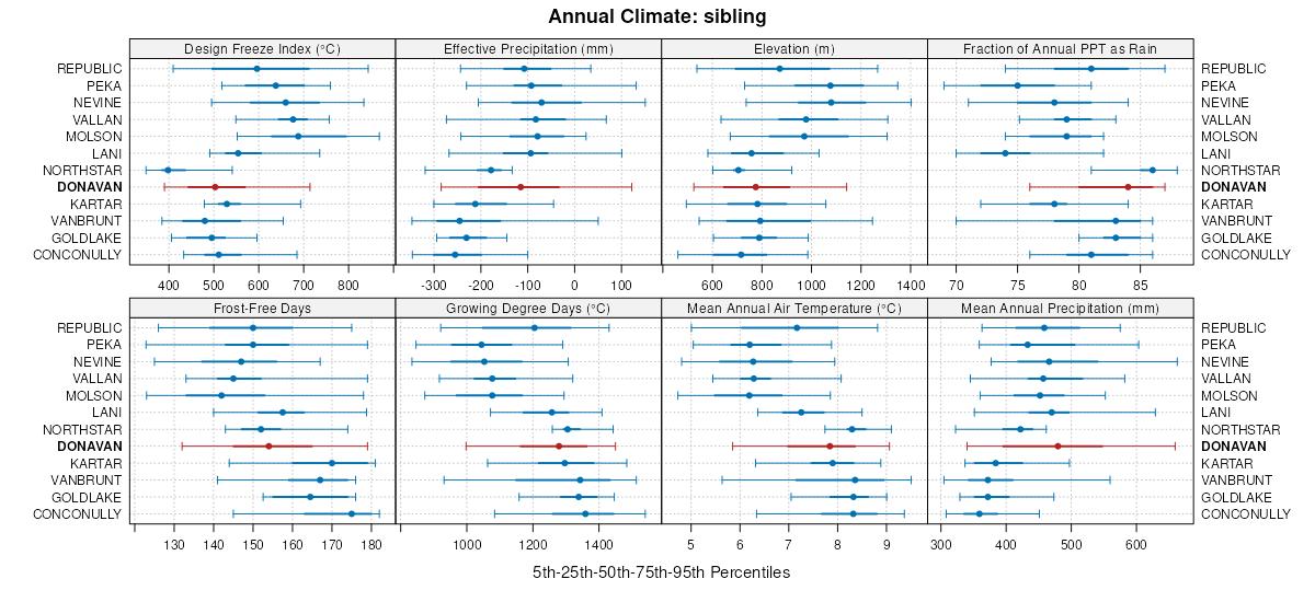
Donavan stony loam, 30 to 65 percent slopes754696915827759pqwa06519781:24000
Donavan-Rock outcrop complex, 30 to 65 percent slopes773407215827959pswa06519781:24000
Rock outcrop-Donavan complex, 30 to 65 percent slopes1902961015815759kvwa06519781:24000
Donavan loam, 8 to 25 percent slopes711490015827359plwa06519781:24000
Donavan stony loam, 0 to 30 percent slopes741145515827659ppwa06519781:24000
Donavan loam, 25 to 40 percent slopes72457515827459pmwa06519781:24000
Donavan loam, 0 to 8 percent slopes70278615827259pkwa06519781:24000
Donavan loam, 40 to 65 percent slopes73120815827559pnwa06519781:24000
Donavan-Rock outcrop complex, 0 to 30 percent slopes7686615827859prwa06519781:24000
Donavan-Rock land-Nevine complex, 15 to 50 percent slopesDrE8374700622bx2wa61919681:24000
Donavan stony loam, 25 to 65 percent slopesDoF6744700612bx1wa61919681:24000
Donavan stony loam, 0 to 25 percent slopesDoD2832700602bx0wa61919681:24000
Donavan loam, 8 to 30 percent slopesDnD1259700582bwywa61919681:24000
Donavan loam, 30 to 65 percent slopesDnF686700592bwzwa61919681:24000
Donavan loam, 0 to 8 percent slopesDnB259700572bwxwa61919681:24000
Donavan loam, dry, 5 to 15 percent slopes12812974702432c2xwa64819871:24000
Donavan loam, dry, 15 to 30 percent slopes1295988702442c2ywa64819871:24000
Donavan bouldery sandy loam, warm, 5 to 20 percent slopes1263723702412c2vwa64819871:24000
Donavan sandy loam, warm, 5 to 15 percent slopes1243443702392c2swa64819871:24000
Donavan, warm-Rock outcrop complex, 5 to 20 percent slopes1352916702512c35wa64819871:24000
Donavan bouldery sandy loam, warm, 20 to 40 percent slopes1272221702422c2wwa64819871:24000
Donavan bouldery loam, dry, 5 to 20 percent slopes1312108702472c31wa64819871:24000
Donavan, dry-Rock outcrop complex, 20 to 40 percent slopes1371627702532c37wa64819871:24000
Donavan, warm-Rock outcrop complex, 20 to 40 percent slopes1381313702542c38wa64819871:24000
Donavan, dry-Northstar complex, 5 to 30 percent slopes1341201702502c34wa64819871:24000
Donavan, dry-Rock outcrop complex, 5 to 20 percent slopes1361118702522c36wa64819871:24000
Donavan loam, dry, 30 to 65 percent slopes130979702462c30wa64819871:24000
Donavan sandy loam, warm, 15 to 30 percent slopes125945702402c2twa64819871:24000
Donavan bouldery loam, dry, 20 to 40 percent slopes132698702482c32wa64819871:24000
Donavan, dry-Goldlake complex, 0 to 15 percent slopes133607702492c33wa64819871:24000
Lithic Haploxerepts-Donavan-Rock outcrop complex, 15 to 45 percent slopes34034635189979221rwmwa64920081:24000
Donavan-Rock outcrop complex, 20 to 40 percent slopes27222115189975721rvhwa64920081:24000
Donavan ashy loam, 0 to 25 percent slopes, extremely stony2706065189975521rvfwa64920081:24000
Donavan ashy loam, 8 to 25 percent slopes2685480189975321rvcwa64920081:24000
Donavan ashy loam, 25 to 65 percent slopes, extremely stony2713760189975621rvgwa64920081:24000
Peka-Donavan complex, 15 to 35 percent slopes4503440189993221s14wa64920081:24000
Donavan ashy loam, 30 to 65 percent slopes2692770189975421rvdwa64920081:24000
Rock outcrop-Donavan-Peka complex, 15 to 35 percent slopes4771580189993921s1cwa64920081:24000
Donavan ashy loam, 3 to 15 percent slopes2671230189993121s13wa64920081:24000
Conconully-Donavan complex, 15 to 65 percent slopes2521200190007721s5twa64920081:24000
Lithic Haploxerepts-Donavan-Rock outcrop complex, 15 to 45 percent slopes2093424613855nlrswa74920051:24000
Peka-Donavan complex, 15 to 35 percent slopes2923075757752jvcwa74920051:24000
Donavan ashy loam, 3 to 15 percent slopes159837757742jvbwa74920051:24000
Donavan ashy sandy loam, 15 to 35 percent slopes161397760422k3zwa74920051:24000
Rock outcrop-Donavan-Peka complex, 15 to 35 percent slopes316227757892jvtwa74920051:24000
Donavan-Rock outcrop complex, 25 to 65 percent slopes162127613835nlr4wa74920051:24000
Donavan ashy loam, 8 to 25 percent slopes16075613830nlqzwa74920051:24000

Map of Series Extent

Approximate geographic distribution of the DONAVAN soil series. To learn more about how this distribution was mapped, or to compare this soil series extent to others, use the Series Extent Explorer (SEE) application. Source: generalization of SSURGO geometry .